Chapter 78. Map Quiz for Chapter 3

78.1

true
true
Chapter 3: The Foundation of Indian Society to 300 C.E.
Map Quiz for Chapter 3
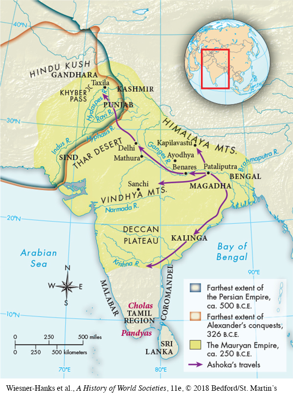
Map is of the Saudi Arabian Peninsula, India, and Western Europe.  To the north of the Caspian and Black Seas is a shaded area indicating the possible Indo-European homeland.  Two arrows move westward into Europe, one goes between the two seas and then westward into what is modern day Turkey.  Another arrow moves eastward to the Indian peninsula.  Most of the northern Indian peninsula is shaded brown, indicating the Aryan settlement ca. 900 B.C.E.  The majority of the map, including the northern Indian peninsula, the area north of the Persian Gulf, and the areas around the Black and Caspian Seas are shaded light green, indicating the extent of Indo-European speakers.
Map of Indo-European Migration in the Vedic Age

Select the best answer for each question. Click the “Submit” button for each question to turn in your work. Click the "Previous" button to navigate back if you need to view the textbook.

Question 78.1

Correct. The answer is B.
Incorrect. The answer is B.
HJMIav6YlpbUoIG/ZT4Wt+D1E124ZGQZsLj4LtJbZ5Fcw7tPBEjcub9k2jnQDEnahY+N1PYV96RCLvpuS/oo13KRlH01FhbDnMfBhNEwesVae944n2EsGuMY97FGQvX8tx3xGjsKjD/hdBmlc5OnXQuSE8bFDogVVH7AoUuN15EPlNcfuBU3nbvYgmfCgvEc+x4JCP7q5xDIg8M9cu922OxKPv2jNQm4YK+Js8k5m6BrBBFEK21k4TiglIM=

Question 78.2

Correct. The answer is D.
Incorrect. The answer is D.
5VOhq/OxAzLyTYGxx5DXlagdaqHJke89vqVNbWzoMoLvJGW1ExFSTTJQFJJStTeTl7W+tmnWKx2X/JItEKTZKwY2SJjyXBKpKQdnNjOmhrwEgftbazYm94Rqhdc51sYi1+uyHI5pqvnAyPmP6skApYB7IDdgdvdtft7aW3wlpHhQDUpmftQZbH41C04mmujl0mlI8cmb+97Btqd91N96zqrG8tmr6b5Kwyb6gigEm8hjCO0afuh6Dhy7xfxayKnGdgr4OauWlDU=

Question 78.3

Correct. The answer is C.
Incorrect. The answer is C.
LfdDquEXVfhhFh32wz6Q75qwFXFkphPWFcvWyU1yvw0izpS3oY+YUkS9x2v4RGSVphfXPWEE20RmOHGcDRpx+K7fUbvSeLsHJcZvJqn3zY4o7vvCTiQptE0gvwz56jdONU7jDzBnovW1QhpYDn7SqAxOOg5WuLabv7zfVdbKvKcTzcne