156.1 Section Title
true
true
Chapter 24: Ideologies of Change in Europe 1815–1914
Map Quiz for Chapter 24
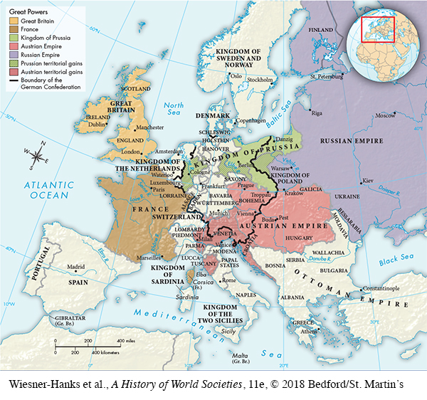
Map of Europe in 1815
Select the best answer for each question. Click the “Submit” button for each question to turn in your work. Click the "Previous" button to navigate back if you need to view the textbook.
1 of 3
Correct. The answer is C.
Incorrect. The answer is C.
whAw9uNVosrCpW+ZMyTYqRwol5XV4NBB65WT5IpeVA2LmhShJFeeKVs7an7FhVVC/A9LGvhEzDxDliCAYPIjySJWN8Fn7cvkhwfBNZVbWgLXa7SwrxLXimi3kwfdFTFHR8mOwl7ugkSgFWZjwcLgrtDx/tFfUxIoRbHuOGIkIbJtyl84eXPSCkA3Y6oq5yt9hRr3VNZr8I5g+nCVyqrVPaoW+TrauXJTlJyOserYQ6QbMnYdx/sErDAE0jTlOSroWd+gBBfs9QLoLLpQxPq/INVQOFc=
2 of 3
Correct. The answer is D.
Incorrect. The answer is D.
PR/QmpKBPGhWmcbBPwSJEYaj5+3VprtrM/GGpkNgCmAcvnGd4uCYmAIAJPhP961S9Tlqf3/MtPUXC55AlZhRdmfr4KZwMnlMJoE71y6AMkkIOnTXjf9dRtXeBGviLN+WnJMfoOoxMFnWzMl7aLncdArwkvHqiBJMN58bKj/y3DiIpSpbiZ/6VonYe/ekuHkWmZ2XhCw+wKFvR6XXiJIENdaXmX0il7/rlf6xpZ341bXsVsy2V47svQ==
3 of 3
Correct. The answer is B.
Incorrect. The answer is B.
OH43s/OzEuAoWc8kc7N1bWK0lt7iFC0eHHsmJgVJOE0chU1bOgnt31WXOWff1Z+tN39fRPB1Zu/hLu0/7zvTCLAPzQJC1o2XwSZ0+wayXZcTuZIaUSbQ6nZf07erqwS8S07NZ3AGNBBpavcnOiwEGIyMO7b+UhbOS8NcSkFJsa1dxRTXIoyRLAnMD5g+ET2MNXSsB6l3jf6njTR7IEi44AjX3Y/7R5z6Pjb9BPyVAeA3z9ilFvMxhy66ZpfcMdIG