Learning from Other Writers
| National Geographic | Photo Essay |
| Hurricane Katrina Pictures: Then & Now, Ruin & Rebirth | |
National Geographic compiled a series of images showing how New Orleans has recovered since the immediate impact of Hurricane Katrina, which hit the area in 2005. Click through the slideshow to view all of the pictures and read the accompanying text, and then answer the questions that follow.
Mario Tama/Getty Images
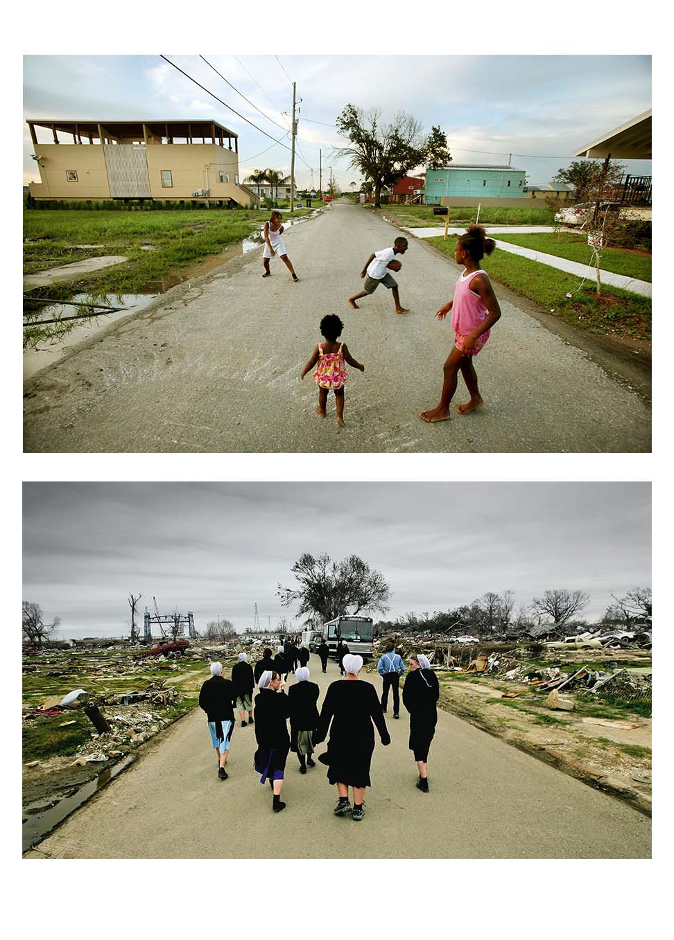
A New Hope
On August 20 children play in a new development in New Orleans’ Lower Ninth Ward built by the Make it Right Foundation, which is constructing houses for families who lost their homes during Hurricane Katrina.
The low-lying Lower Ninth Ward took the brunt of the storm’s devastation five years ago but later attracted an army of volunteers eager to help rebuild (pictured, Amish student volunteers tour the area on February 25, 2006).
Ng Staff/National Geographic Stock
Mario Tama/Getty Images
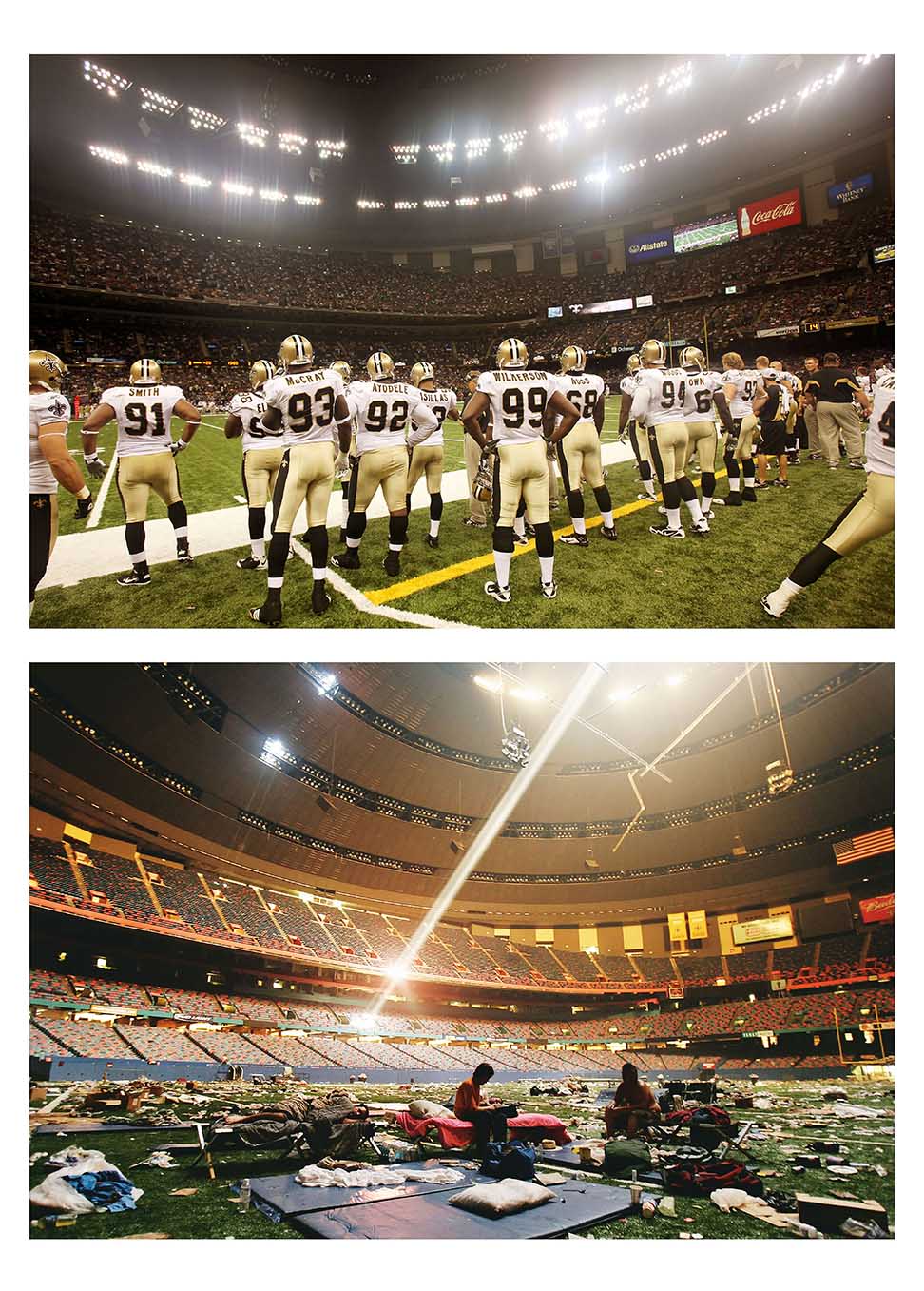
Hurricane Katrina Waiting Game
The New Orleans Saints play a preseason game Saturday against the Houston Texans in the Louisiana Superdome (top)—a whole different ball game from five years ago, when the stadium was a makeshift shelter for victims of Hurricane Katrina.
As the fifth anniversary of Hurricane Katrina’s Gulf Coast landfall approaches, many hurricane survivors are still homeless, according to a new report by the homeless-advocacy group Unity of Greater New Orleans, local TV station WWLV.com reported.
Hundreds of Katrina victims are living in the more than 55,000 ramshackle buildings that were abandoned after the hurricane destroyed much of the city, according to the report.
Katrina, the most destructive and costliest natural disaster yet to occur in the United States, killed more than 1,800 people. In total, five million people were affected by the storm and its aftermath, according to Harvard University’s Hurricane Katrina Community Advisory Group.
Ng Staff/National Geographic Stock
Mario Tama/Getty Images
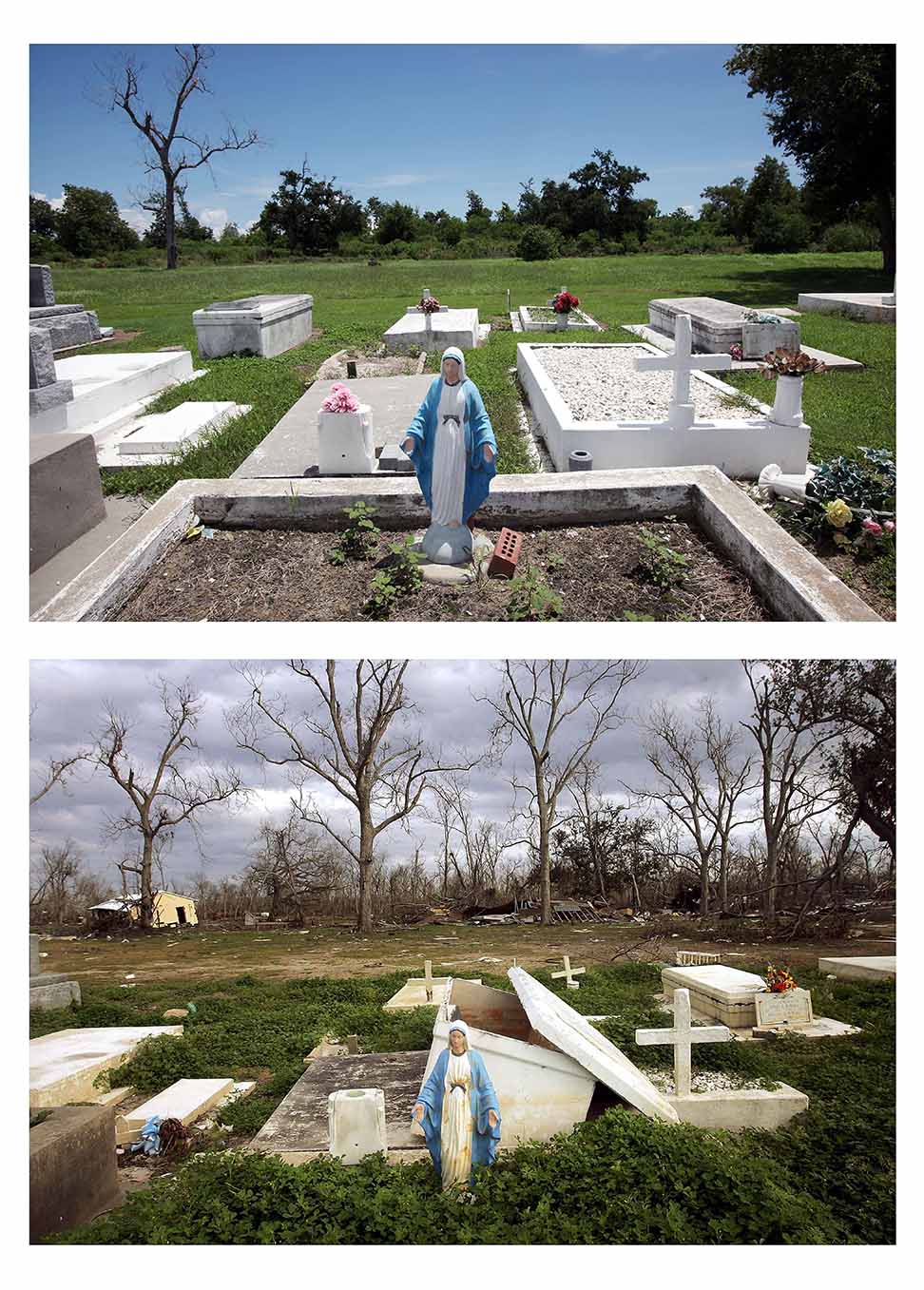
Come Hell or High Water
A Virgin Mary statue tops a crypt in an above-ground cemetery in Buras, Louisiana, on August 19 (top). The same scene in February 2006 shows the jumble of debris created when Hurricane Katrina floodwaters swept through the cemetery.
The deluge opened several crypts and caused some coffins to float away, according to the Getty news service.
In some areas, storm surges nearly three stories high wreaked havoc on coastal and inland communities alike.
Ng Staff/National Geographic Stock
Mario Tama/Getty Images
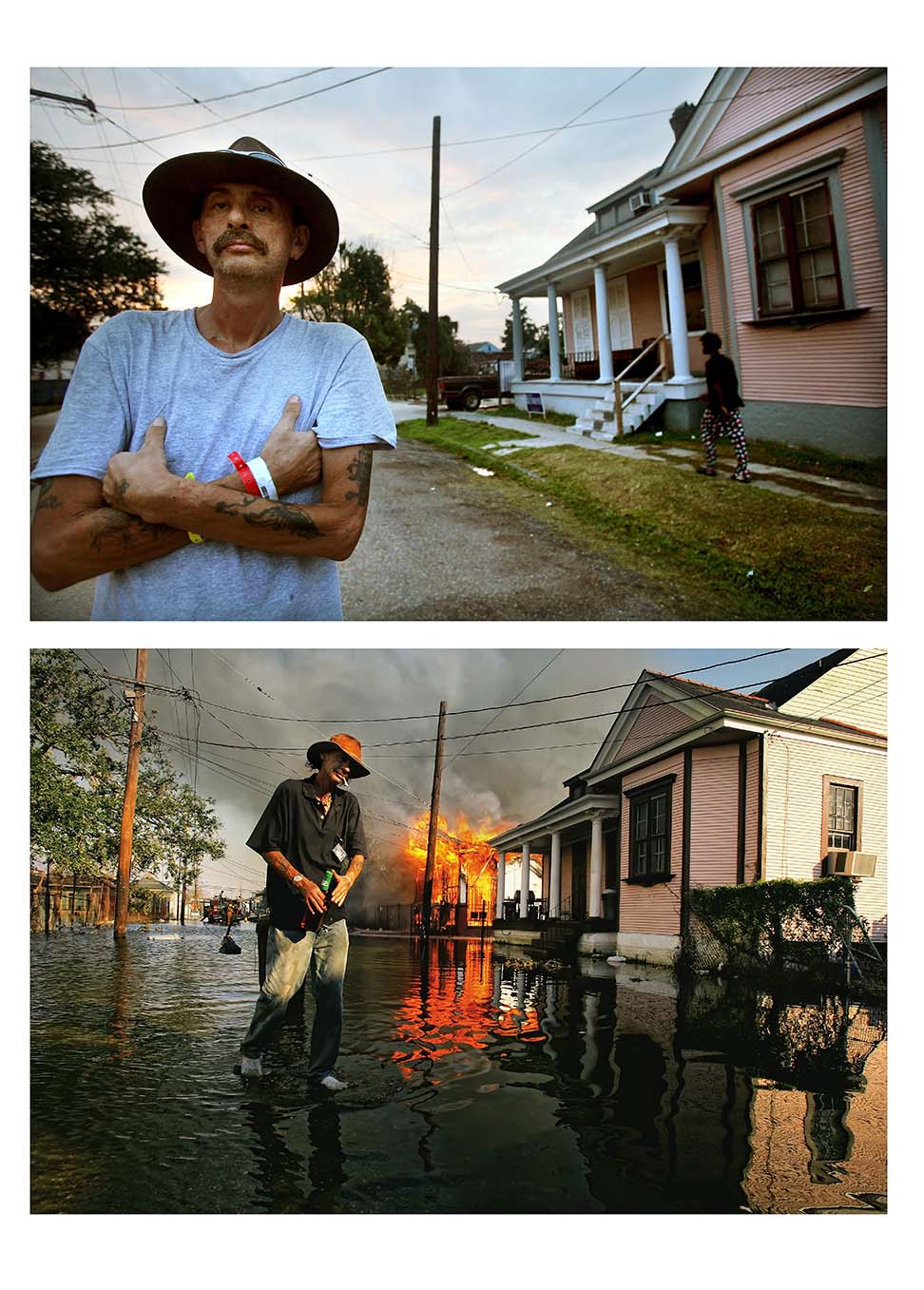
Hurricane Katrina’s Line of Fire
On August 23 Robert Fontaine returned to the New Orleans street corner (top) where a house he’d been living in burned on September 6, 2005. Though others had evacuated the city, Fontaine stuck it out without electricity to take care of abandoned dogs, one of which knocked over a candle and caused the fire.
“My whole life, my whole world crashed. For everyone, not just for me,“ Fontaine told Getty last week.
Five years later, with many of Katrina’s scars still visible throughout New Orleans, the U.S. government announced it would contribute more than $26.8 million to Louisiana to help with rebuilding projects, CNN reported earlier this week.
Ng Staff/National Geographic Stock
Courtesy of the U.S. Geological Survey
Gone With the Waves
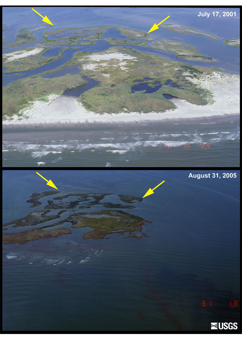
A latticework of narrow beaches, sand flats, dunes, and marshes southeast of New Orleans, Louisiana’s Chandeleur Islands (seen at top in July 2001) were largely submerged by Hurricane Katrina’s powerful storm surge, pictured at bottom on August 31, 2005.
Within days the surge stripped sand from beaches and ate away large sections of marsh from the island chain, leaving few recognizable landforms in its wake, according to the U.S. Geological Survey.
Today the Chandeleur Islands are in hot water again due to the Gulf of Mexico’s Deepwater Horizon oil spill, which coated many of the area’s shorebirds with oil.
Ng Staff/National Geographic Stock
Courtesy of the U.S. Geological Survey
Hurricane Katrina Hits Home
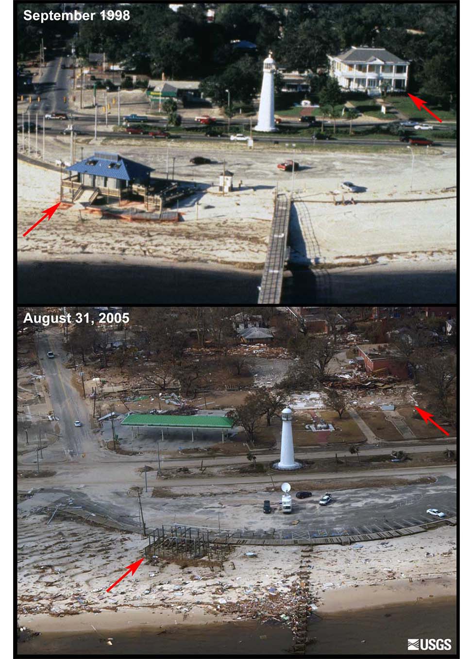
Now you see it, now you don’t—beach homes in Biloxi, Mississippi—pictured in 1998 (top) and 2005—were wiped out after Hurricane Katrina made landfall.
Katrina’s storm surge reached up to 12 miles (19 kilometers) inland in Mississippi
Ng Staff/National Geographic Stock
Mario Tama/Getty Images
A New Hope
On August 20 children play in a new development in New Orleans’ Lower Ninth Ward built by the Make it Right Foundation, which is constructing houses for families who lost their homes during Hurricane Katrina.
The low-lying Lower Ninth Ward took the brunt of the storm’s devastation five years ago but later attracted an army of volunteers eager to help rebuild (pictured, Amish student volunteers tour the area on February 25, 2006).
Ng Staff/National Geographic Stock
Questions to Start You Thinking
Meaning
Question
Question
Question
Writing Strategies
Question
Question
Question
Question