MARS
Mars’s distinctive rust-colored hue (Figure 6-55) makes it stand out in the night sky. For centuries Mars has generated more excitement as a possible home for alien life than any other world in our solar system. The idea began following the first well-documented telescopic observations of Mars in 1659 by the Dutch physicist Christiaan Huygens. Huygens identified a prominent, dark surface feature that reemerged about every 24 hours, suggesting (correctly) a rate of rotation similar to that of Earth.
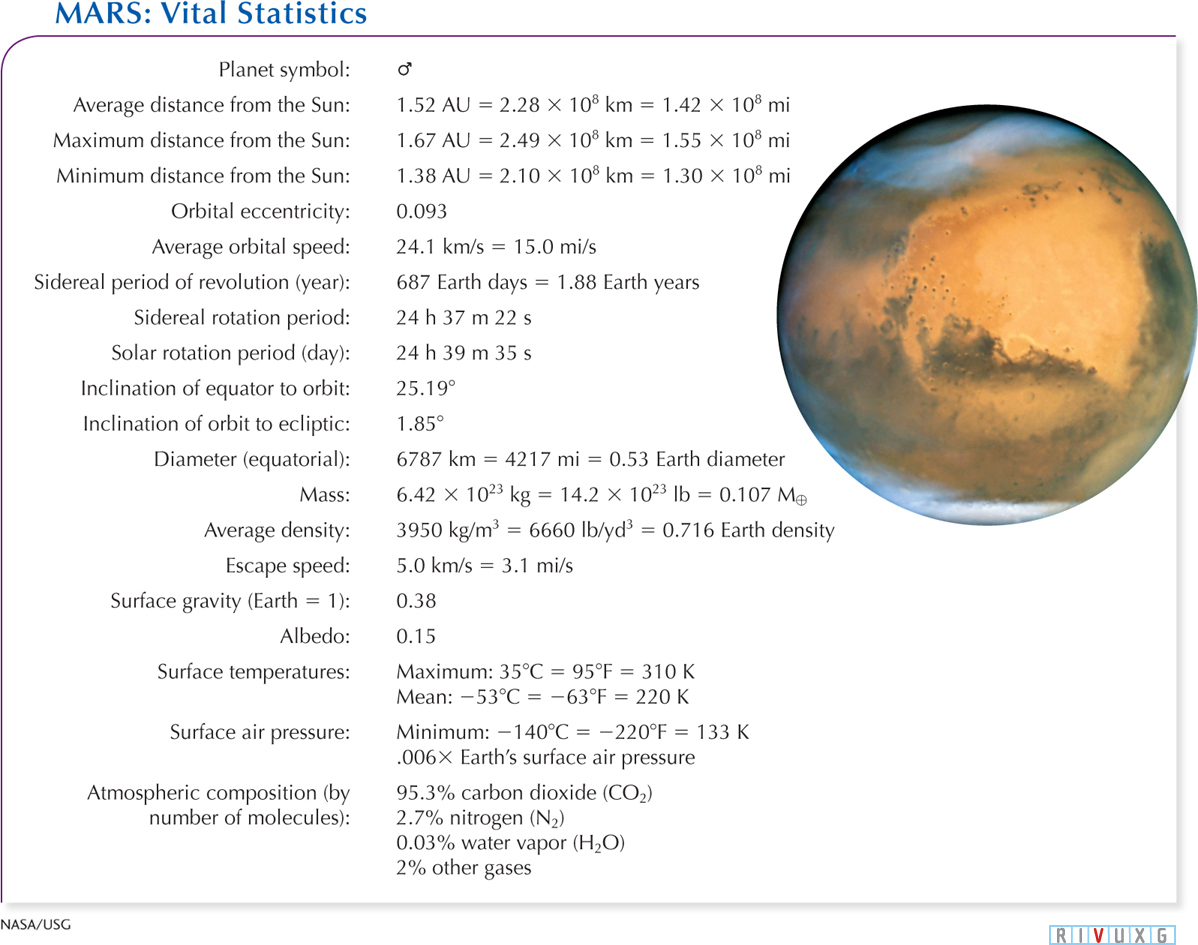
Figure 6-55  Mars’s Vital Statistics The lighter orange region in the center of the photograph in this figure is called Arabia Terra, after the Arabian peninsula on Earth.
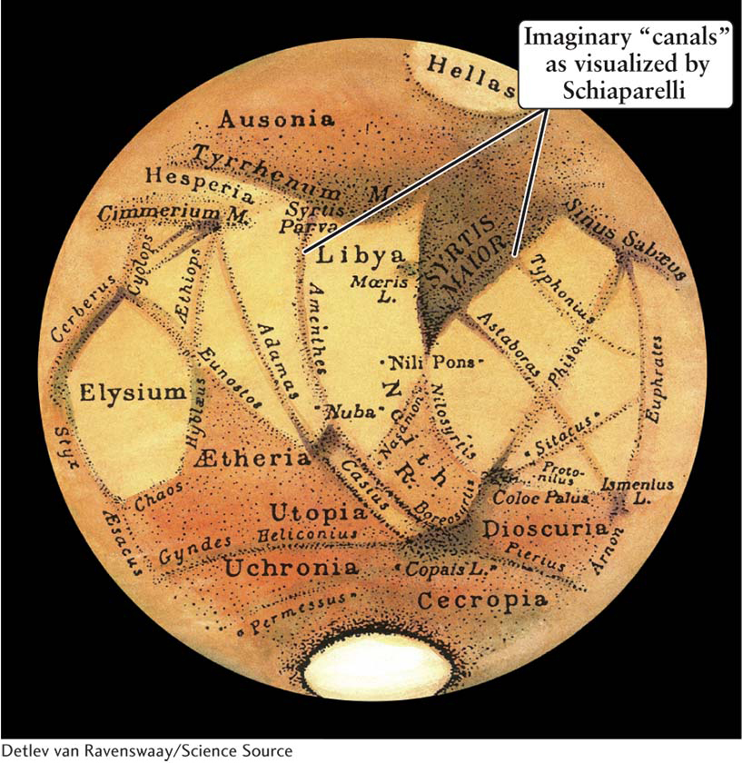
Figure 6-56 The Illusion of Martian Canals Giovanni Schiaparelli examined Mars through a telescope 20 cm (8 in) in diameter, the same size used by many amateur astronomers today. His drawings of the red planet showed features perceived by Percival Lowell and others as irrigation canals. Higher-resolution images from Earth and spacecraft visiting Mars failed to show the same features.
Belief that advanced life exists on Mars skyrocketed at the end of the nineteenth century after Giovanni Virginio Schiaparelli, an Italian astronomer, reported in 1877 seeing 40 lines crisscrossing the Martian surface (Figure 6-56). He called these dark features canali, an Italian term meaning “channels.” It was soon mistranslated into English as canals, implying the existence on Mars of intelligent creatures capable of engineering feats. This speculation led Percival Lowell, scion of a wealthy Boston family, to finance a major new observatory near Flagstaff, Arizona. By the end of the nineteenth century, Lowell had allegedly observed 160 Martian “canals.”
By the beginning of the twentieth century, it was fashionable to speculate that the Martian canals formed an enormous, planetwide irrigation network to transport water from melting polar ice caps to vegetation near the equator. In view of the planet’s reddish, desert-like appearance, Mars was thought to be a dying planet whose inhabitants must go to great lengths to irrigate their farmlands. No doubt the Martians would readily abandon their arid ancestral homeland and invade Earth for its abundant resources, an idea brought to life in 1898 by H. G. Wells in War of the Worlds. Ironically, we now have on the surface of Mars a spacecraft, Curiosity, which is zapping that planet’s surface with a laser reminiscent of the death rays depicted in the Wells story. That laser has zapped Mars’s surface over 100,000 times, vaporizing small amounts of it, and a spectroscope on Curiosity analyzes the chemical composition of the released gases. This analysis, combined with analysis of regolith scooped up by Curiosity, reveals the presence of perchlorate (a chlorine compound used in rocket fuel on Earth), water, a variety of rocks with unexpected chemical compositions, and relatively large grains of various minerals.
Insight Into Science
Perception and Reality Our tendency to see patterns, even where they do not exist, makes it easy for us to leap to unjustified conclusions. Scientific images and photographs require objective analysis. This is why scientific discoveries are not considered to be authentic until they have been reproduced and verified by independent researchers.
6-18 Mars’s global features include plains, canyons, craters, and volcanoes
As noted in Figure 6-55, Mars has only about 11% the mass and half the diameter of Earth. While Mercury’s small size and mass may have been due to a major collision when that planet was young, it appears that Mars is relatively small because Jupiter swept up much of the mass that would have gone into Mars, as discussed in Section 4-3.
Spacecraft journeying to Mars have sent back pictures since the 1970s. They show that Mars’s surface is completely dry and that it has broad plains, shallow craters, enormous inactive volcanoes, and vast canyons (Figure 6-57). The broad northern plain is called Vastitas Borealis (Latin for northern waste or northern devastation) and is shown in blue on Figure 6-57. This plain is some 5 km (3 mi) below the much more heavily cratered and hilly plains in the south, called the southern highlands. The cause of the significant difference in heights of the two hemispheres is not known, but it may stem from either early tectonic activity (see Section 6-3 for a discussion of tectonics) or from a powerful early impact.
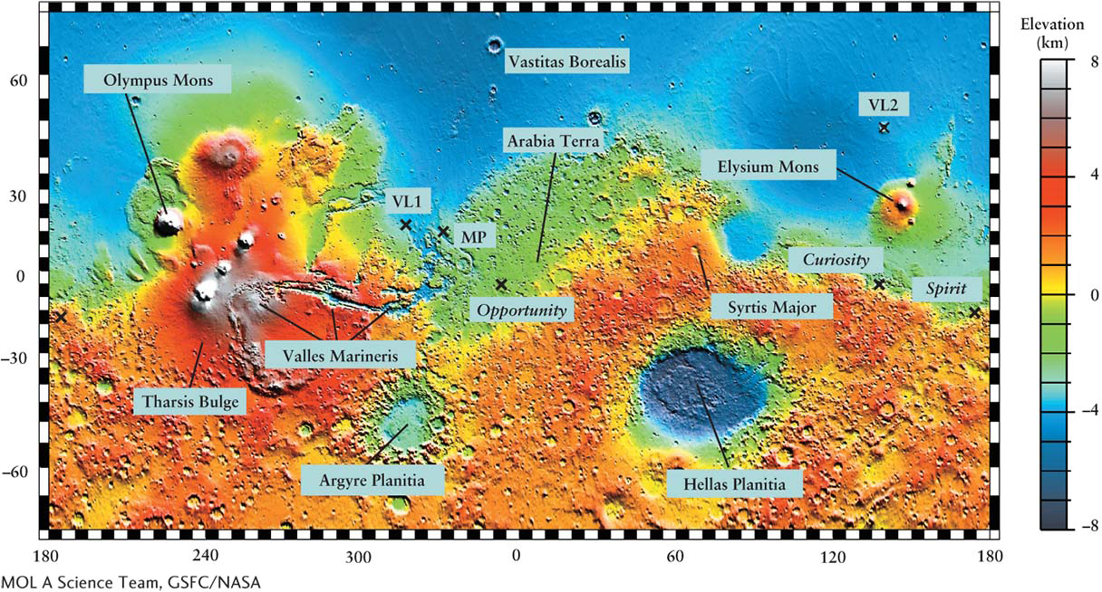
Figure 6-57 The Topography of Mars The color coding on this map of Mars shows elevations above (positive numbers) or below (negative numbers) the planet’s average radius. To produce this map, an instrument on board Mars Global Surveyor fired pulses of a light at the planet’s surface, then measured how long it took each reflected pulse to return to the spacecraft. The Viking 1 Lander (VL1), Viking 2 Lander (VL2), Mars Pathfinder (MP), Opportunity, and Spirit landing sites are each marked with an X. The volcanoes depicted in white are higher than the scale on the right can show.
Between the two hemispheres, Mariner 9 discovered a vast canyon now called Valles Marineris, which runs roughly parallel to the Martian equator (Figure 6-58). Valles Marineris stretches over 4000 km (2500 mi), about one-fifth the circumference of Mars. If this canyon were located on Earth, it would stretch from New York to Los Angeles. The individual canyons that make up Valles Marineris are up to 8 km (5 mi) deep and 200 km (125 mi) wide. Valles Marineris begins with heavily fractured terrain in the west and ends with ancient-cratered terrain in the east. Geologists believe that the western part of Valles Marineris was created by tectonic plate motion on the young Mars. Data taken between 1999 and today reveal magnetic fields locked into parts of Mars’s surface in just the same way that separating tectonic plates lock magnetic fields into Earth’s rock on the boundaries between Earth’s tectonic plates.
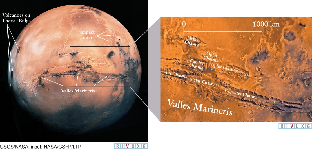
Figure 6-58
Martian Terrain This high-altitude photograph shows a variety of the features on Mars, including enormous volcanoes (left) on the highland, called Tharsis Bulge; impact craters (upper right); and vast, windswept plains. The enormous Valles Marineris canyon system crosses horizontally just below the center of the image. Inset: Details of the Valles Marineris, which is about 200 km (120 mi) wide in this image. The canyon floor has two major levels. The northern (upper) canyon floor is 8 km (5 mi) beneath the surrounding plateau, whereas the southern canyon floor is only 5 km (3 mi) below the plateau.
Some of the eastern parts of Valles Marineris appear to have been formed almost entirely by water flow, similar to Earth’s Grand Canyon, which is 9 times shorter and 4 times less deep than Valles Marineris. Although remote observations such as those made by the Mariner and myriad other spacecraft have strongly suggested water has long existed on Mars, the chemical verification of water there, in the form of ice, was first made in 2008 by the Phoenix Mars Lander. In 2013, the Curiosity rover analyzed soil samples and determined that they contain 2% water.
Most impact craters are located in Mars’s southern hemisphere (Figure 6-59). This suggests that the Vastitas Borealis has been resurfaced by some process that eradicated ancient lowland craters, consistent with either of the earlier explanations of the differences in hemispheres.
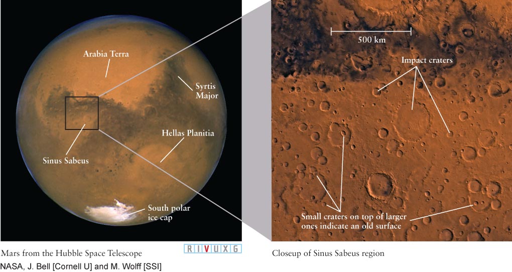
Figure 6-59
Craters on Mars This image taken by the Hubble Space Telescope was made during the opposition of 2003. Arabia Terra looks like the Arabian peninsula on Earth. It is an old, highly eroded region dotted with numerous flat-bottom craters. Lava-covered Syrtis Major was first identified by Christiaan Huygens in 1659. A single impact carved out Hellas Planitia, which is 5 times the size of Texas. Inset: This mosaic of images from the Viking 1 and 2 orbiter spacecraft shows an extensively cratered region located south of the Martian equator. Note how worn down these craters are compared to those on Mercury and our Moon.
Focus Question 6-16
What two major activities created Valles Marineris?
Most of the volcanoes on Mars are located in the northern hemisphere. The largest volcano in the solar system, Olympus Mons (Figure 6-60a), covers an area as big as the state of Missouri and rises 26 km (16 mi) above the surrounding plains—nearly 3 times the height of Mount Everest. The highest volcano on Earth, Mauna Loa in the Hawaiian Islands, has a summit only 17 km (11 mi) above the ocean floor. Olympus Mons is a shield volcano, meaning that the lava poured down its sides, rather than being violently ejected. That manner of flow is evident in the inset of Figure 6-60a. While we do not know the active history of Olympus Mons, it is as high as it is in part because the lower gravity on Mars allowed the lava that issued from it to flow downhill more slowly than occurs on Earth. The lava solidified before it had spread out as much as occurs on Earth’s shield volcanoes, thereby building up thicker layers and a taller volcano than the same flow would have created on Earth.
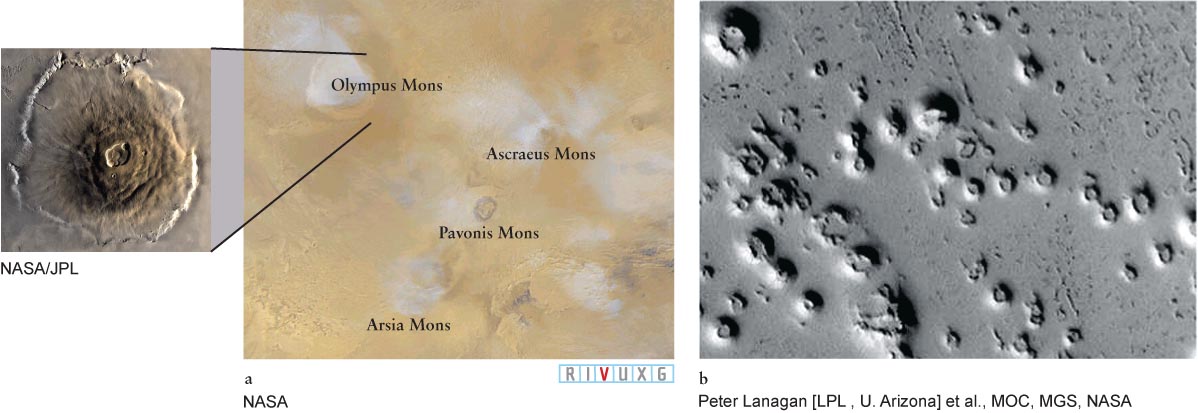
Figure 6-60
Volcanoes on Mars (a) Clouds of water vapor on Mars. Inset: Olympus Mons, the largest volcano on Mars (and in the solar system). (b) These cones on Mars may have been created when lava from Olympus Mons heated underground ice, causing the resulting water and vapor to expand, raise the planet’s surface, and burst out.
Around Olympus Mons and other volcanoes, orbiting spacecraft have observed numerous cratered, cone-shaped features that are typically the size of a football field (Figure 6-60b). These cones are believed to have been created by ice below the Martian surface that was liquefied and vaporized by lava from the nearby volcanoes. The expanding water pushed its way up to the surface, deforming the land before exploding out the centers of these “ice” volcanoes. Similar clusters of cones on Earth, formed by the same mechanism, are found in Iceland.
Astronomers have discovered impact craters on Mars that formed in the past few years. In one case, an image showed no craters, whereas an image taken 67 days later of the same area revealed a cluster of newly formed, small craters. On each California-sized patch of land on Mars, about two 1.0-m (1.1-yd) craters are created each year. Careful study of these new craters shows that they uncovered ice that had been buried only a meter or two under the planet’s surface before the meteorite struck.
High-resolution photographs of Mars taken over the past 40 years, as shown on the previous pages, have failed to show one canal of a size consistent with those allegedly seen from Earth (see Figure 6-56). We now know for certain that Schiaparelli’s canali were optical illusions, and the science fiction writers who wrote about advanced cultures there were completely off the mark.
Insight Into Science
Science Fact and Fiction Science fiction may foreshadow real scientific discoveries. (Can you think of some examples?) But science also reins in the fantasies of the science fiction writer. A century ago, millions of people, including top scientists, believed that technologically advanced life existed on Mars. However, all the scientific evidence says otherwise.
6-19 Although no canals exist on Mars, it does have some curious natural features
Mars not only lacks canals, but it also has no cities, roads, or other signs of civilization. However, astronomers have photographed several surface features that, at first glance, could have been crafted by intelligent life-forms. In 1976, a hundred years after Schiaparelli’s alleged discovery of canali, the Viking 1 orbiter spacecraft photographed a feature that appeared to be a humanlike face (Figure 6-61a). However, when the Mars Global Surveyor photographed the surface in greater detail in 1998 (Figure 6-61b), it found only natural structures: This feature was formed when softer rock eroded around a region of harder, less easily eroded rock.
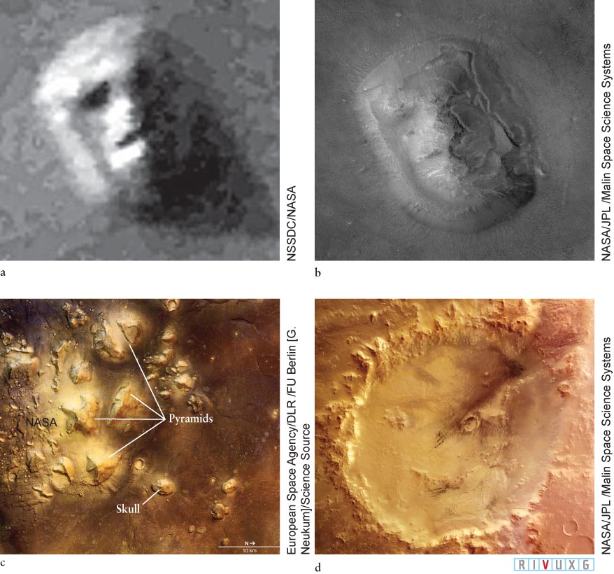
Figure 6-61
In the Eye of the Beholder Images (a) and (b) are of the same site on Mars, taken 22 years apart. They show how, at high resolution, the apparent face in (a) changed to a more “natural-looking” feature in (b). This change in appearance was due to improved camera technology. (c) In the same region of Mars, other erosion features also appear to be pyramids and skulls. (d) The Galle crater and its interior features combine to give the impression of a “happy face.”
Other photographs show a collection of pyramids, a skull (Figure 6-61c), and a “happy face” (Figure 6-61d). Are any of these features relics of an advanced civilization? Scientists universally believe that they are all naturally formed features. Like the face in Figures 6-61a and b, the pyramids and skull are consistent with winds eroding softer rock around harder rock pushed upward from inside Mars billions of years ago. The same thing happens on Earth. The happy face is made from a large impact crater and several small natural features inside it.
6-20 Mars’s interior is less molten than the inside of Earth
Part of the Valles Marineris was apparently formed when large regions of Mars’s surface moved apart due to tectonic plate motion. This activity is generated by the flow of rock under the planet’s surface (see Section 6-3 for more on plate tectonics). However, there is no evidence that plate tectonic activity occurs on Mars today. This lack of activity indicates that more of Mars’s interior is cooled solid rock than exists inside Earth. This conclusion is supported by the observation that Mars lacks a global magnetic field (see Section 6-5 for discussion of the field-generating dynamo effect). However, observations made in 2003 revealed that the Sun creates tiny tides (less than a centimeter) on the solid body of Mars. As the land rises and sinks ever so slightly through the day on Mars, friction created by this motion in the planet’s interior provides enough heat to keep some of the interior molten. (Rub your hands vigorously together to see how friction creates heat.)
Focus Question 6-17
Have you ever seen something that you interpreted as one thing, but it turned out to be something else?
Although a global magnetic field on Mars is absent today, there are remnants of such a field. In 1997 the Mars Global Surveyor (which operated until 2006) discovered patterns of local surface magnetic fields in a variety of places on Mars (Figure 6-62), similar to regions on Earth where tectonic plates separate and lock Earth’s magnetic field in the rock (see Section 6-5). Geologists propose that when Mars was young, its internal “dynamo” created a strong magnetic field and that tectonic plates helped craft its surface while locking traces of its changing magnetic field in the then-molten rock. However, the planet quickly cooled, its global magnetic field vanished, and tectonic plate activity apparently ceased nearly 4 billion years ago.
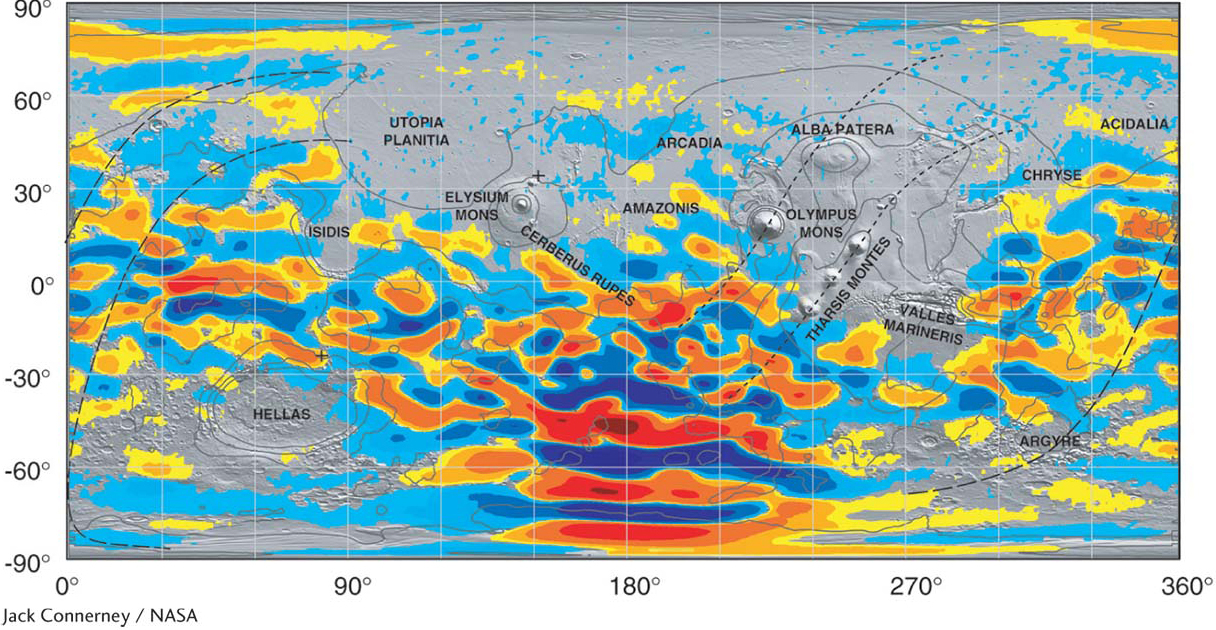
Figure 6-62 The Local Magnetic Fields on Mars Unlike Earth, with its global magnetic field, Mars has only local magnetic fields, shown here in the regions of yellow and orange. They are believed to emanate from magnetized rock under the planet’s surface.
A more molten interior early in its existence is also consistent with the enormous volcanoes that exist on Mars. Volcanoes are places where molten rock oozes or bursts from a body’s interior. Most of the volcanoes on Mars are the type where molten rock oozed out, called shield volcanoes, like the ones that created the Hawaiian Islands. Such volcanoes are very different from Mount Fuji in Japan or Mount Etna in Sicily, where the material from inside Earth is ejected violently. The first such volcano on Mars was discovered in 2013. On Earth, the Hawaiian Islands are only the most recent additions to a long chain of islands created by the growth of shield volcanoes rising through Earth’s crust under the Pacific Ocean. These volcanoes resulted from hot-spot volcanism, a process by which molten rock rises to the surface from a fixed hot region far below. The Pacific tectonic plate is slowly moving northwest at a rate of several centimeters per year. As a result, new volcanoes are created above the hot spot, while older ones move off and become extinct, eventually disappearing beneath the ocean. In the Atlantic Ocean, the Eyjafjallajökull volcano in Iceland (see Figure 6-48), which erupted in 2010, is located on a hot spot.
Insight Into Science
Keep It Simple II Was the Martian “face” made by intelligent life or by wind-sculpted hills? When two or more alternative interpretations present themselves, scientists apply the principle of Occam’s razor (see Section 2-1) and always choose the explanation that requires the fewest unproven assumptions.
Because Mars’s surface is apparently frozen in place due to the lack of ongoing tectonic plate motion, a hot spot can keep pumping lava upward through the same vent for millions of years. One result is Olympus Mons—a single giant volcano rather than a long chain of smaller ones (see Figure 6-60a). This volcano’s summit has collapsed to form a volcanic crater, called a caldera, large enough to contain the state of Rhode Island. Because Mars’s solid crust and mantle (the region directly below the surface) are now so thick, they insulate the surface, preventing any more molten rock from escaping. Therefore, we do not expect to see any more large-scale volcanic activity there.
The thickness of Mars’s solid crust and mantle and, hence, its ability to support great weight above it were emphasized in 2008, when radar on the Mars Reconnaissance Orbiter circling Mars observed that the planet’s surface does not buckle under the weight of its north polar ice cap. Earth has a thinner solid outer layer of crust and mantle, as indicated by the fact that our planet warps under similar ice layers. As a consequence of this discovery, astronomers have concluded that liquid water, if it exists under the northern Vastitas Borealis, is deeper inside the planet than previously thought. If that liquid water exists and there is life in it, then that life lies deep inside the planet.
The Martian crust, the outer part of its solid structure, is at least 40 km (25 mi) thick under the Vastitas Borealis and 70 km (43 mi) thick under the southern highlands. However, the boundary between the thin and thick crusts does not line up with the boundary between high and low terrain. Current models of Mars suggest that it has a core about 3400 km (2100 mi) in diameter and that at least some of that core is molten. A detailed understanding of Mars’s interior waits for the placing of seismic detectors on the planet’s surface.
6-21 Martian air is thin and often filled with dust
To understand more about the activity on Mars’s surface, we must examine its atmosphere, which today has only 0.6% the pressure of Earth’s atmosphere. As on Venus, some 95% of Mars’s thin atmosphere is composed of carbon dioxide. The remaining 5% consists of nitrogen, argon, water vapor, and traces of oxygen. Unlike the gravitational attraction of tiny Mercury, which is too weak to hold any gases as a permanent atmosphere, Mars’s gravitational force is just strong enough to prevent carbon dioxide, nitrogen, argon, and oxygen from escaping into space, but not strong enough to hold down water vapor.
A growing body of evidence indicates that there was once a vast water-filled ocean in the northern hemisphere of Mars and smaller bodies of water in numerous places over the entire planet. Evidence for the ocean includes layers of rock deposited by water and channels in which water from the south flowed northward. Observations made in 2008 suggest that liquid water existed on the surface of Mars for 2½ billion years—in other words, until about 2 billion years ago. One of the factors that would have enabled the oceans to exist as long as they did was that Mars is believed to have had a much thicker atmosphere in the past. More air above it makes it harder for liquid water to evaporate. That atmosphere would have decreased in density for several reasons, including some gases in the upper atmosphere being heated enough to fly into space, some air molecules in the upper atmosphere being broken apart by ultraviolet radiation from the Sun and then drifting into space, some gases freezing and being buried under the surface, and some gases dissolving in the oceans.
Focus Question 6-18
If the Hawaiian Islands were fixed over their hot spot, rather than moving, what would happen to them?
Eventually, much of Mars’s surface water evaporated and drifted into space, never to return. The rest either froze or was entrapped in underground lakes. Today, the concentration of water vapor in Mars’s atmosphere is 30 times lower than it is in Earth’s air. If all of the water vapor could somehow be squeezed out of the Martian atmosphere, it would not fill even one of the five Great Lakes of North America. The remainder of the water that was on Mars’s surface has turned to ice, much of which remains there today. Most of that water has been covered with finely powdered, wind-blown regolith, which is why we do not see frozen lakes or similar features. Since 2002, satellites orbiting Mars have discovered enough water ice under Mars’s southern pole to cover the entire planet to a depth of 11 m (36 ft). In 2008, the Phoenix Mars Lander dug into the Martian regolith and observed ice just under the surface. Chemical tests made by it confirmed that the ice was frozen water, rather than frozen carbon dioxide or other compound. Water ice is being discovered at many latitudes from the polar regions to the equator. In 2008, the Mars Reconnaissance Orbiter discovered buried glaciers extending dozens of kilometers from mountains and cliffs. It is certain that much more water remains to be found inside Mars.
Despite the low density of Mars’s air, the red planet experiences Earthlike seasons because of a striking coincidence, first noted in the late 1700s by the German-born English astronomer William Herschel. Just as Earth’s equatorial plane is tilted 23½° from the plane of its orbit, Mars’s equator makes an angle of about 25° from the plane of its orbit. If, as is now suspected, the northern hemisphere of Mars is lower than the southern hemisphere because the north was struck by a large body, that impact could have also tilted the planet and initiated the seasons there. The Martian seasons last nearly twice as long as Earth’s, because Mars takes nearly 2 Earth years to orbit the Sun. When Mars is near opposition, even current telescopes for home use reveal its daily changes. Dark seasonal markings on the Martian surface can be seen to vary, and prominent polar caps of frozen carbon dioxide shrink noticeably during the spring and summer months (Figure 6-63).
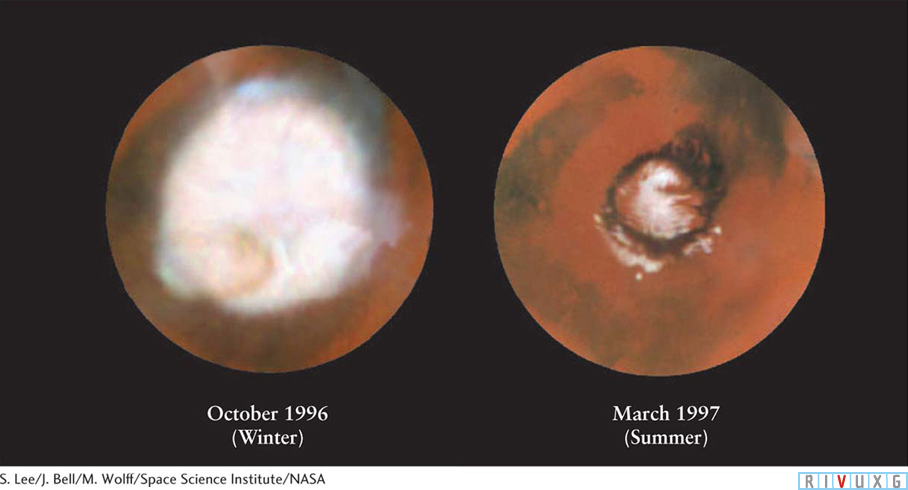
Figure 6-63
Changing Seasons on Mars During the Martian winter, the temperature decreases so much that carbon dioxide freezes out of the Martian atmosphere. A thin coating of carbon dioxide frost covers a broad region around Mars’s north pole. During the summer in the northern hemisphere, the range of this north polar carbon dioxide cap decreases dramatically. During the summer, a ring of dark sand dunes is exposed around Mars’s north pole.
In 1994, astronomers using computer simulations discovered that the axis tilts of rapidly rotating planets, like Mars and Earth, are prone to change over millions of years unless such a planet is stabilized by the presence of a massive moon. Earth has such a moon; hence, our planet maintains its present 23½° tilt, but the two tiny moons of Mars do not have enough gravitational attraction to keep the orbital inclination of Mars from changing dramatically. Observations of the underground polar regions by the Mars Reconnaissance Orbiter reveal seasonal changes on Mars and changes in the chemistry of its atmosphere over periods of millions of years consistent with changes in the tilt of Mars’s rotation axis far from its present 25°.
Although sometimes blue (Figure 6-64a), Mars’s atmosphere is often pastel red, sometimes turning shades of pink and russet (Figure 6-64b). All of these latter colors are due to fine dust blown from the planet’s desertlike surface during windstorms. The dust is iron oxide, familiar here on Earth as rust. Mars’s sky also changes color because the amount of dust in the air varies with the season. During the winter, carbon dioxide ice adheres to the dust particles and drags them to the ground. This helps clear and lighten the air. In the summer months, the carbon dioxide is not frozen, and the dust blown by surface winds remains aloft longer.
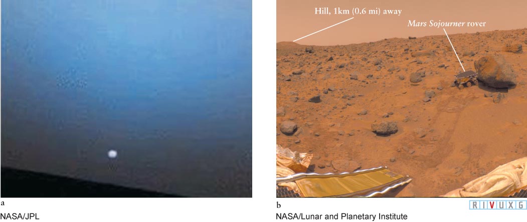
Figure 6-64
The Atmosphere of Mars (a) When Mars’s sky is relatively free of dust, it appears similar in color to our sky, as shown in this sunset photo taken by the rover Opportunity. The darker, brown color in which the Sun is immersed is due to lingering dust in the sky. When less dust is present, the Sun looks almost white during Martian sunsets. Most of the images we have of Mars’s sky show colors like those seen in (b). (b) Taken by the Mars Pathfinder, this photograph shows the Sojourner rover snuggled against a rock named Moe on the Ares Vallis to run tests on the rock. At the top of the image, the pink color of the Martian sky is evident.
The sky color also changes over periods of many years. In 1995, for example, the amount of dust was observed to have dropped dramatically compared to that observed in the 1970s. The reason for such long-term changes is still under investigation.
As on Earth, the temperature changes with the seasons on Mars. For example, one day at the landing site of the rover Spirit, near the equator, the temperature ranged from 188 K (−120°F) to 243 K (−22°F), whereas 100 days later it ranged from 200 K to 263 K (−100°F to 14°F, see Figure 6-57 for the site location). During the afternoons, heat from the planet’s surface warms the air and sometimes creates whirlwinds, called dust devils (Figure 6-65). A similar phenomenon occurs in dry or desert terrain on Earth. Martian dust devils reach altitudes of 12 km (7.5 mi). Spacecraft on Mars detect drops in air pressure as dust devils sweep past, just as on Earth. Some dust devils are large enough to be seen by orbiting spacecraft.
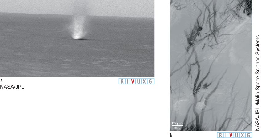
Figure 6-65
Martian Dust Devil (a) This Spirit image is one in a movie sequence of a dust devil moving left to right across the surface of Mars. The rovers have filmed several such events. (b) These dark streaks are the paths of dust devils on the Argyre Planitia of Mars. The tracks cross hills, sand dunes, and boulder fields, among other features on the planet’s surface.
The winds on Mars help explain why its surface is eroding. Over the past two centuries, astronomers have seen faint surface markings disappear under a reddish-orange haze as thin Martian winds have stirred up finely powdered dust from the Martian regolith. Some storms obscure the entire planet, as happened in 2001. Over the ages, winds have worn down crater walls, and deposits of dust have filled in the crater bottoms (Figure 6-66). But the Martian atmosphere is so thin that 3 billion years of sporadic storms have not carried enough of Mars’s extremely fine-grained powder to eradicate the craters completely.
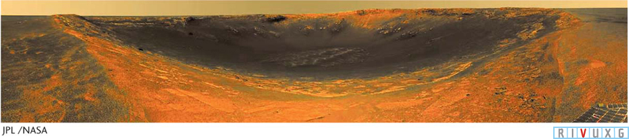
Figure 6-66
Crater Endurance Photographed by the rover Opportunity, this crater on Mars is about 130 m (430 ft) across. Rocks are visible in the crater and in vertical cliffs along its walls. By studying such rocks, astronomers hope to understand more of the history of water on Mars.
6-22 Surface and underground features indicate that water once flowed on Mars
Focus Question 6-19
Why do you think it is easier to stand up in a dust devil on Mars than in the same equivalent-speed event on Earth?
Despite disproving the theory that Mars has broad canals or any other liquid surface water, Mars-orbiting spacecraft did reveal many dried-up riverbeds (Figure 6-67a); river deltas (Figure 6-68), where water and debris emptied into lakes and oceans; lakes (Figure 6-68a); sedimentation laid down by water flow (Figure 6-69); and other water-related features. Some of the river-beds include intricate branched patterns and delicate channels meandering among flat-bottomed craters. Rivers on Earth invariably follow similarly winding courses (Figure 6-67b).
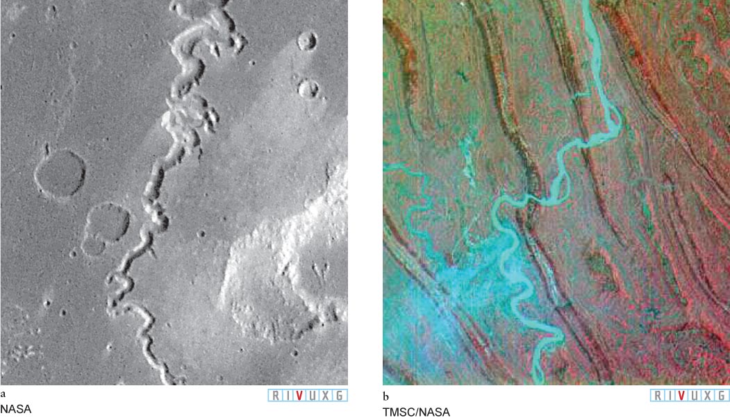
Figure 6-67
Rivers on Mars and Earth (a) Winding canyons on Mars, such as the one in this Viking 1 orbiter image, appear to have been formed by sustained water flow. This theory is supported by the terraces seen on the canyon walls in high-resolution Mars Global Surveyor images. Long periods of water flow require that the planet’s atmosphere was once thicker and its climate more Earthlike. (b) The Yangtze River near Chongqing, China. Typical of rivers on Earth, it shows the same snakelike curve as the river channels on Mars.
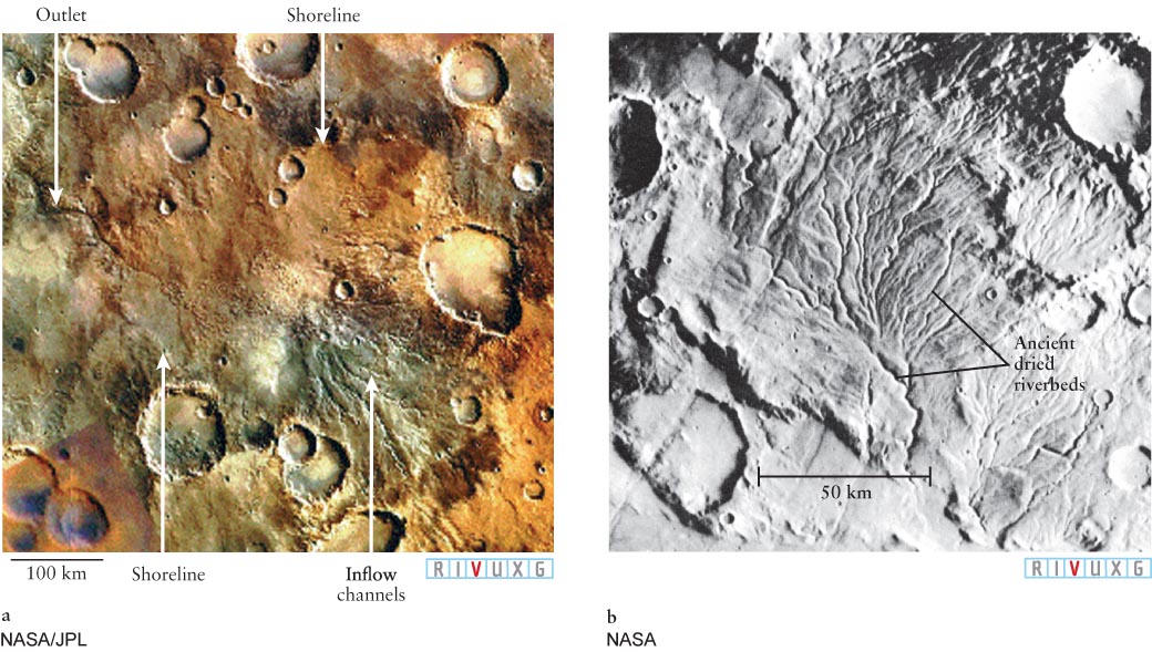
Figure 6-68
Evidence of Water on Mars (a) This dry Martian lake, photographed by the Mars Global Surveyor with a resolution of 1.5 m (1.6 yd), is an excellent example of how geology and astronomy overlap. The features of this dry lake are consistent with those found on lakebeds on Earth. (b) This network of dry riverbeds is located on Mars’s cratered southern hemisphere.
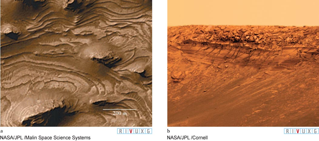
Figure 6-69
Ancient Oceans and Lakes on Mars (a) This Mars Global Surveyor image of a portion of Valles Marineris reveals terrain with “stair-step layers.” Such terrain is likely to have been created by sedimentation at the bottom of an ancient body of water. (b) This image of Burns Cliff, photographed by the rover Opportunity, shows a close-up of layers of rock laid down on a body of water on Mars that went through wet and dry periods.
Surface rovers Spirit and Opportunity found strong evidence supporting the belief that water created many of these features (Figure 6-70), including the presence of water-formed hematite—iron-rich rocks that look like blueberries—and rocks with extremely high levels of salts that had previously been dissolved in liquid water. Such salts take millions of years to seep into rocks in the quantities they have been found, implying that liquid water was on the red planet’s surface for at least that length of time. The rover Curiosity rode over a riverbed in 2012, adding more credence to the belief that water once flowed on the red planet. On the other hand, observations show that the clay deposits laid down by liquid water on some parts of Mars are relatively thin, suggesting that while water was on the surface in some places for billions of years, there are other places on the surface where it lasted for much shorter lengths of time. Some of the clay on Mars appears to have come from lava flows, weakening further the case for extended liquid water coverage everywhere on the planet. About 6% of Mars’s surface is covered with material of volcanic origin.
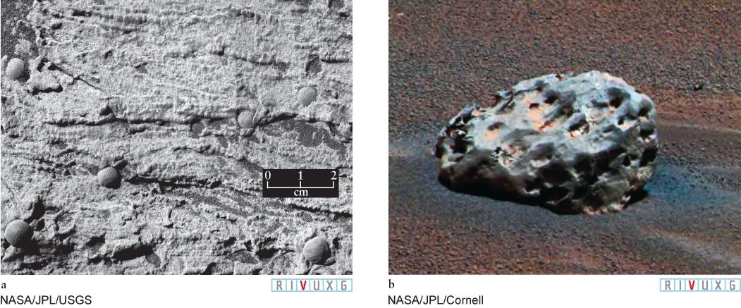
Figure 6-70
Layers of Rock Laid Down by Water (a) This close-up image taken by the rover Opportunity shows a small section of rock layers in a location called the Dells. The angled and curved layering seen here is created only on Earth by water flow, strongly suggesting that this sediment was also deposited by water. The nearly spherical rocks, called “blueberries” because they are dark, have been chemically identified as hematite, an iron-rich mineral that is usually formed in water. The rovers have found blueberries strewn in a wide variety of locations. (b) This iron meteorite, dubbed the “Heat Shield Rock” because it was discovered behind the Mars rover Sojourner’s heat shield, is surrounded by hematite blueberries.
The origin of at least some of the water that was on Mars is believed to have been ice-rich bodies that struck the surface, releasing their water into the atmosphere, where it later rained down on the surface. Although water existed on Mars’s surface for long periods, there are indications in several places that large bodies of water have been gone for billions of years, as mentioned earlier. The evidence for this is the discovery by the rovers of lava rocks that contain olivine and pyroxene, rocks that dissolve quickly in water. If these rocks came to the surface while there was still water on it, these two minerals in the rock would have been dissolved away.
The surface of Mars continues to change. For instance, images taken by Mars Global Surveyor of one crater wall show that, sometime between 1999 and 2005, there was a significant landslide on it (Figure 6-71a, b). While this new feature was initially attributed to liquid water gushing out and initiating the landslide, subsequent observations of similar activity suggest that the crater wall is so steep that dry sandy material could have begun sliding due to a small Marsquake (earthquake on Mars) or a tremor created by a meteorite impact. Mars Reconnaissance Orbiter has discovered that Mars is being struck by at least 200 pieces of space debris that create craters at least 3.9 m (12.8 ft) across each year. In 2014, astronomers reported observations of streaks that change color seasonally (Figure 6-71c) that may be the first signs of active water on the red planet. The water can be liquid even in the cold temperatures of Mars’s summer if it is salty, which lowers its melting point.
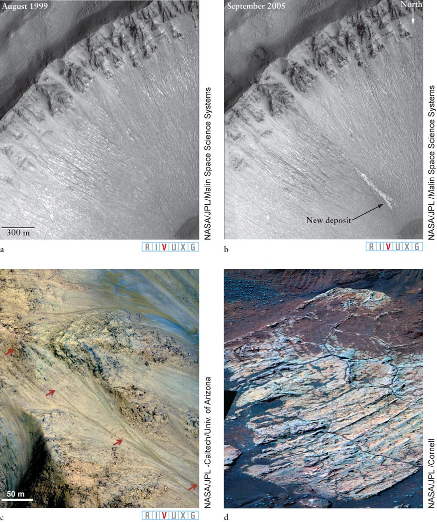
Figure 6-71
Martian Gullies (a, b) Two images of the same southern hemisphere crater on Mars taken 6 years apart. Whether the new deposit was initiated by ground vibration or by a short period of liquid water flow from inside Mars is still under investigation. (c) The arrows in this picture, taken of a crater in the Valles Marineris, show streaks that fade away in the winter. This may be an indication of water flow. (d) Polygonal cracks are visible in this Opportunity image of Escher Rock. They were believed to have formed when his area was flooded. Water seeped into the rock, which cracked as the water froze, expanded, and then sublimated away.
In 2008, astronomers using the Mars Reconnaissance Orbiter observed avalanches in progress close to Mars’s north pole, where liquid water is even less likely to exist near the surface today (Figure 6-72). Another example of change is Mars’s sand dunes, which have been observed to vary as a result of winds acting on them.
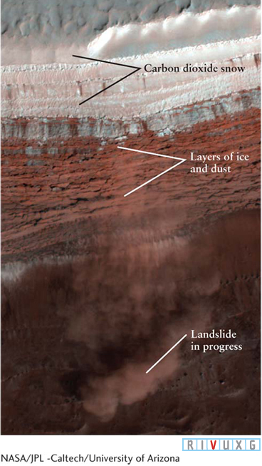
Figure 6-72
An Active Avalanche on Mars This image, taken by the Mars Reconnaissance Orbiter, shows an active landslide of falling ice, dust, and rock. This debris first hit the cliff wall about halfway down and then continued falling down the less steep slope, as seen in the bottom of the image. The cloud of debris near the bottom is about 180 m (590 ft) wide.
In 2004, the rover Opportunity discovered Martian rock (Figure 6-71d) with polygon-shaped cracks similar to dried mud flats found on Earth. The best explanation for these features on Mars is that long after the lakes and oceans dried there, an impact released water from inside the planet that briefly reflooded the surface rock. The water seeped into the rock, and upon freezing, the water expanded and cracked the rock. This scenario would require vast amounts of water inside Mars for several reasons. First, most of the liberated water heated by the impact would have left as vapor. Second, liquid water on the surface would not persist very long because of the low air pressure. When air pressure is very low, molecules easily escape from a liquid’s surface, which would cause water to vaporize. Because the pressure of Mars’s atmosphere is only 0.6% that of Earth’s atmosphere, any liquid water on Mars today would quickly transform into ice or furiously boil and evaporate into the thin Martian air and then be lost into space. Thus, if liquid water did cause the rock formations seen by Opportunity, there must have been a lot of it to start with, in order for there to be enough to cover the large areas of the Martian surface that have such cracks.
The total amount of water that once existed on Mars’s surface is not known. However, by studying flood channels that exist there, geologists estimate that there was once enough water to cover the planet to a depth of 500 m (1500 ft). As noted earlier, Earth has enough water to cover our planet to a depth of 2.8 km (1.7 mi), assuming that Earth’s surface was everywhere a uniform height.
Further evidence that water once flowed on Mars comes from so-called SNC meteorites found on Earth (Figure 6-73a). These space rocks are believed to have once been pieces of Mars because their chemistries are consistent with those of rocks studied on Mars’s surface and because they contain trace gases in relative amounts found only in the current Martian atmosphere. The meteorites were ejected into space during especially powerful impacts on that planet’s surface. They also contain water-soaked clay, which is not expected to be found on any objects in the solar system besides Mars, Earth, and Jupiter’s moons Europa, Ganymede, and Callisto. At least 132 meteorites from Mars have been identified.
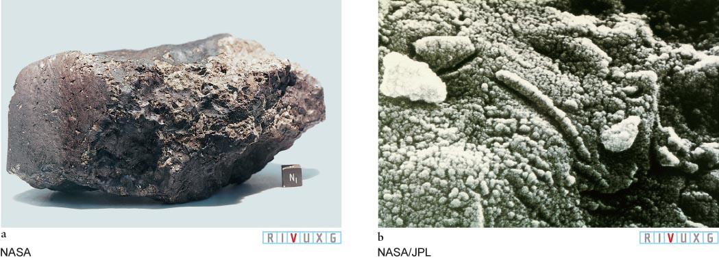
Figure 6-73
A Piece of Mars on Earth Mars’s thin atmosphere does little to protect it from impacts. Some of the debris ejected from impact craters there apparently traveled to Earth. (a) An SNC meteorite recovered in Antarctica. The 4.1-billion-year-old meteorite, designated ALH84001, shows strong evidence of having been exposed to liquid water on Mars, perhaps for hundreds of years. (b) Possible fossil remains of primitive bacterial life on Mars, although theories of nonbiological origins have also been presented.
Some of the water that was on Mars is still near the surface today, frozen in several places on the red planet from its poles to its equator. Recent satellite measurements indicate that the ice at the north pole is mostly water ice and extends down about 2.0 km (1.2 mi). The south pole has layers of water ice and dry ice (frozen carbon dioxide) in roughly equal amounts. The water ice is atop the dry ice there. The temperature at Mars’s poles, typically 160 K (−70°F), keeps the water permanently frozen, like the permafrost found in Siberia and Antarctica. Seasonal variations at Mars’s poles (see Figure 6-63) are created by the freezing and sublimating of dry ice, which reaches a thickness of 2.0 m (2.2 yd). Indeed, during the winter, about one-third of the carbon dioxide in that hemisphere of Mars’s atmosphere precipitates down as dry-ice snow.
The 1997 visit by Pathfinder and its little rover (see Figure 6-64b) to the Ares Vallis revealed evidence of several floods at the mouth of a dried flood plain. This evidence includes layers of sediment, clumps of rock and sand stuck together like similar groupings created by water on Earth, rounded rocks worn down as they were dragged by the water, and rocks aligned by water flow. The rover performed some 20 chemical analyses of rocks in the landing area. The soil at the site is a rusty color, laden with sulfur. The source of this sulfur is a mystery, as is the large amount of silicon-rich rock the rover explored.
There is observational evidence of an ancient shoreline encircling the Vastitas Borealis of Mars. The belief that the northern regions were an ocean long ago is supported by the analysis of a 1.2-billion-year-old meteorite from Mars. This rock has remnants of salt believed to have been deposited there when the Martian ocean dried up.
Dried remains of underground water channels have also been discovered on Mars. Radar signals from the Mars Reconnaissance Orbiter regularly penetrate Mars’s surface to a depth of 1 km (0.6 mi). The return signals are processed into images showing that under the surface are concentrations of rock that appear to have been islands shaped by water flow around them. The depths of these features suggest that they were formed within the past 500 million years. The underground source of the water and the reason it flowed are still under investigation.
6-23 Search for microscopic life on Mars continues
The discovery in the 1960s that water once existed on the surface of Mars rekindled speculation about Martian life. Although it was clear that Mars has neither civilizations nor fields of plants, microbial life-forms still seemed possible. Searching for signs of organic matter was one of the main objectives of the ambitious and highly successful Viking missions.
The two Viking spacecraft were launched during the summer of 1975. Each consisted of two modules—an orbiter and a lander. Almost one year later, both Viking landers set down on rocky plains north of the Martian equator.
The landers confirmed the long-held suspicion that the red color of the planet is due to large quantities of iron in its soil. Despite the high iron content of its crust, Mars has a lower average density of 3950 kg/m3 (3.0 tons/yd3) than that of other terrestrial planets (this value is more than 5000 kg/m3 (3.8 tons/yd3) for Mercury, Venus, and Earth). Mars must therefore contain overall a smaller percentage of iron than these other planets.
Each Viking lander was able to dig into the Martian regolith and retrieve rock samples for analysis, which showed that the rocks at both sites are rich in iron, silicon, and sulfur. The Martian regolith (Figure 6-74) ranges in consistency from clay to sand, although its chemistry is different from clay and sand on Earth. In 2012, Curiosity analyzed regolith on another part of Mars, finding it to contain olivine, feldspar, and pyroxene, which are often found in volcanic soil on Earth that has undergone extensive weathering.
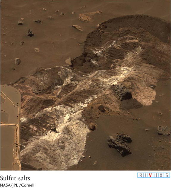
Figure 6-74
Regolith of Mars The rover Spirit’s wheels churned up the regolith of Mars, revealing sulfur-based salts just below the surface.
The Viking landers each carried a compact biological laboratory designed to test for microorganisms in the Martian soil. Three biological experiments were conducted, each based on the idea that living things alter their environment: They eat, they breathe, and they release waste products.
During each experiment, a sample of the Martian regolith was placed in a closed container, with or without a nutrient substance. The container was then examined for any changes in its contents. For both landers, two of the experiments gave negative results for life. The third, however, caused great excitement. In this experiment, small amounts of water and nutrients were added and rapid and extensive changes were detected inside the sealed containers. However, further analysis showed that these changes were due solely to nonbiological chemical processes. Apparently, the Martian regolith is rich in chemicals that effervesce (fizz) when moistened. A large amount of oxygen is tied up in the regolith in the form of unstable chemicals called peroxides and superoxides, which break down in the presence of water to release oxygen gas. Complicating matters was the discovery in 2010 that the heat in the sealed containers on the Viking landers may have been so high that the Martian regolith deposited in them was chemically changed before it was analyzed, so that the results neither prove nor disprove the presence of organic compounds in that material.
The chemical reactivity of the Martian regolith comes from the Sun’s ultraviolet radiation and from electric activity inside dust devils. Ultraviolet photons easily break apart molecules of carbon dioxide (CO2) and water vapor (H2O) by knocking off oxygen atoms, which then become loosely attached to chemicals in the regolith. Ultraviolet photons also produce highly reactive ozone (O3) and hydrogen peroxide (H2O2) near the planet’s surface, which become incorporated in the regolith. Dust devils suck up lots of dust from the planet’s surface and transform it into a variety of compounds.
 Here on Earth, hydrogen peroxide is commonly used as an antiseptic. When you pour this liquid on a wound, it fizzes and froths as the loosely attached oxygen atoms chemically combine with organic material and destroy germs. The Viking landers may have failed to detect any organic compounds on Mars because the superoxides and peroxides in the Martian regolith act as antiseptics there, making it sterile. Keep in mind, however, that back when Mars had substantial amounts of water, the surface chemistry was probably substantially different and potentially more supportive of life, if it ever existed there. This is supported by the discovery in 2010 of rocks that contain carbonate that was deposited in wet, nonacidic conditions. This substance dissolves in acid-rich water. In 2013, the rover Curiosity drilled into the rock on Mars and analyzed the resulting powdered rock. While no life was found, carbon, nitrogen, oxygen, sulfur, phosphorus, and hydrogen, important elements for the existence of life, were detected. Furthermore, these data were taken from what had once been a wet environment that would have been chemically hospitable to life.
In 2003, astronomers began detecting methane in Mars’s atmosphere. This discovery is intriguing because sunlight breaks down methane within a few centuries. Therefore, the gas needs to be continuously replenished. Indeed, plumes of methane emerging from the planet’s interior have now been observed. One of these plumes was observed to contain 19,000 tons of the gas. This simple compound, CH4, is often a by-product of biological activity (cows come to mind in this regard). Methane is also trapped inside planets, like Earth and possibly Mars, during their formation and thereafter leaks out. In 2013, the Curiosity rover repeated the search for methane but found none at all. Reconciling these contradictory observations is a work in progress.
Possible signs of ancient life on Mars have been discovered here on Earth. When cut open, several of the Martian meteorites have shown microscopic features that could be fossils of Martian bacterial life and their excretions (see Figure 6-73b). These features, no larger than 500 nm (2 × 10⁻⁴ inches or 1/100 the diameter of a human hair), are 30 times smaller than bacteria found on Earth. Detailed analysis of the meteorites in 2001 revealed the presence of several organically created features, including tiny spheres similar to those found with some Earth bacteria, and magnetite crystals, which are also used by some bacteria on Earth as compasses to find food. The debate as to whether the features in these meteorites are fossil evidence of life on Mars has raged unabated for several years, and it is not yet resolved. (It is worth noting that similar claims of fossils in meteorites from Mars in the 1960s have been disproved.)
The search for microscopic life on Mars continues. If there is liquid water under the Martian surface, then it is entirely possible that life has evolved there and may still exist. This belief is based on the incredibly wide range of places that life has developed in water on Earth, from volcanic vents on the bottoms of oceans to geysers and to lakes under the Antarctic polar ice cap.
6-24 Mars’s two moons look more like potatoes than spheres
Two tiny, irregularly shaped moons orbit close to Mars’s surface. Phobos (Greek, meaning “fear”) and Deimos (“panic”) are so small that they were not discovered until 1877. In mythology, these names are either Mars’s sons by Aphrodite or the two horses that pulled Mars’s war chariot—take your pick. Potato-shaped Phobos is the inner and larger of the two moons (Figure 6-75a). It is heavily cratered, and its surface has been transformed into dust at least 1.0 m (1.1 yd) thick by countless tiny impacts over the eons. Deimos is smaller and less cratered than Phobos (Figure 6-75b).
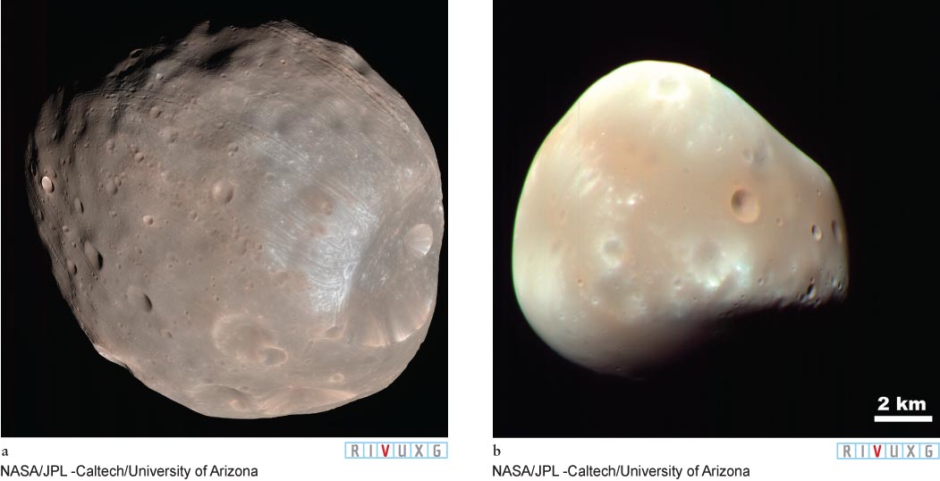
Figure 6-75
Phobos and Deimos (a) Phobos, the larger of Mars’s two moons, is potato-shaped and measures approximately 28 × 23 × 20 km (17 × 14 × 12 mi). It is dominated by crater Stickney (on the right of the image), named for discoverer Asaph Hall’s wife (Angeline Stickney). (b) Deimos is less cratered than Phobos and measures roughly 16 × 12 × 10 km (10 × 7 × 6 mi).
The gravitational deflections by Phobos of spacecraft passing near it have been used to determine the moon’s mass. Measurements of that mass and its volume, made in 2010, reveal a very low density (density = mass/volume), which suggests that Phobos may be extremely porous, with up to 30% of its interior composed of empty space.
Focus Question 6-20
Would our Moon have to be closer or farther away to orbit in the same direction but rise in the west?
Both Phobos and Deimos orbit in the same direction that Mars rotates, just as our Moon orbits Earth. However, Phobos is so close to the planet that this moon goes around 3 times in 1 Martian day. This rapid revolution creates the unusual situation wherein Phobos rises in the west, races across the sky in only 5½ hours as seen from Mars’s equator, and sets in the east. As seen from Mars, Deimos rises in the east and takes about 3 Earth days to creep from one horizon to the other.
Phobos creates tiny tides on Mars, which in turn pull that rapidly orbiting moon inward (just the opposite effect of Earth on our more slowly orbiting Moon). Phobos, descending at a rate of 1.8 m/Earth year (2.0 yd/Earth year), will either strike Mars or be pulled apart by the tidal force and become a ring within 50 million years.
Insight Into Science
Imagine the Moon The definitions we use for words based on our everyday experience often fail us in astronomy. For example, the word moon usually creates an image of a spherical body, like our Moon. In reality, most of the moons in the solar system have very irregular shapes, like Phobos and Deimos.
Phobos and Deimos were not formed like our Moon, which condensed from debris that “splashed” into orbit as the result of a collision between our planet and another large body. For decades Phobos and Deimos were both believed to be captured asteroids (which may still be true for Deimos). While some asteroids have densities as low as that of Phobos, astronomers have trouble showing how Phobos could have been captured and put into its relatively circular orbit without being pulled apart. A viable explanation of Phobos’s presence is still under development. Both moons are in synchronous rotation as they orbit Mars.