Chapter 1. Plate Tectonics
Map Learning Exercises
Question 1 of 2
Plate Tectonics: Plate boundary with subduction
Click on the surface of Earth where there is a convergent plate boundary with subduction.
Consider this schematic cross section illustrating typical depths and elevations of different features on Earth. The shape and elevation of the features can give you enough information to interpret the tectonic environment in which it formed.
{"title":"Correct","description":"The trench marks the location of the convergent boundary with subduction.","type":"correct","color":"#99cc00","code":"[{\"shape\":\"poly\",\"coords\":\"271,301,294,337,252,327\"}]"} {"title":"Ocean","description":"Incorrect: This is the ocean. The plate boundary is where two plates meet, and plates are made of rock.","type":"incorrect","color":"#993300","code":"[{\"shape\":\"poly\",\"coords\":\"270,194,313,261,339,344,338,392,307,393,297,348,289,331,270,295,287,291,269,264,273,252,253,221\"},{\"shape\":\"poly\",\"coords\":\"249,167,267,186,229,201,222,188\"}]"} {"title":"Mountain","description":"Incorrect: These are mountains at the surface of the continental crust.","type":"incorrect","color":"#333300","code":"[{\"shape\":\"poly\",\"coords\":\"7,55,7,2,57,6,123,43,135,79,183,105,202,116,203,120,151,95,128,83,62,63,34,58\"}]"} {"title":"Scalebar","description":"This is the scale bar indicating the elevation of the features shown.","type":"incorrect","color":"#000080","code":"[{\"shape\":\"poly\",\"coords\":\"260,90,294,123,9,391\"}]"} {"title":"Plate","description":"Incorrect: There is no plate boundary here, this is one continuous plate.","type":"incorrect","color":"#333333","code":"[{\"shape\":\"poly\",\"coords\":\"221,192,231,198,273,185,252,225,271,253,266,268,284,291,247,331,293,339,304,394,12,392\"},{\"shape\":\"poly\",\"coords\":\"7,58,103,76,195,121,221,140,7,385\"}]"}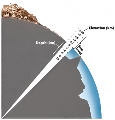
Correct.
Please try again.