Map Quiz

Chapter 8

Map Quiz
Chapter 8
true
true
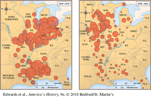
This map shows Western Land Sales from 1830 to 1839 and from 1850 to 1862. As the first map shows for 1830 to 1839, federal government offices sold huge amounts of land in the corn and wheat belt of the Midwest (Ohio, Indiana, Illinois, and Michigan) and the cotton belt to the south (especially Alabama and Mississippi). However, in the second map for 1850 to 1862, the indication is that as settlers moved westward during this period, most sales were in the upper Mississippi River Valley (particularly Iowa and Wisconsin).
MAP 8.2 Western Land Sales, 1830–1839 and 1850–1862

Select the best answer for each question. Click the “submit” button for each question to turn in your work. Click the "Previous" button to navigate back if you need to view the textbook.

Question 1

Which of the following states relied most on navigable rivers for transportation of goods and people by 1850?


Question 2

According to this map, which region relied the most on canals for the transportation of goods and people by 1850?


Question 3

Concerning the transportation of goods and people by 1850, which of the following statements does this map justify?