module 11 Ocean Currents
We have seen that the unequal heating of Earth together with the Coriolis effect drive air currents around the world. These two phenomena also affect ocean currents. In this module, we will explore the circulation of ocean waters, both at the surface and in the deep ocean. We will see how ocean circulation affects the transport of heat around the globe, how this heat movement affects the climates of continents, and how disruptions to these circulation patterns can dramatically alter global climates.
Learning Objectives
After reading this module you should be able to
describe the patterns of surface ocean circulation.
explain the mixing of surface and deep ocean waters from thermohaline circulation.
identify the causes and consequences of the El Niño–
Southern Oscillation.
Surface ocean currents move warm and cold water around the globe
The flow of ocean water is an important factor for global climates because it moves warm and cold waters to different parts of the globe. In doing so, ocean currents affect the primary productivity found in different ocean regions as well as the climate of the adjacent continents. When warm ocean currents flow from the tropics to higher latitudes, the neighboring continents receive warm air from the ocean. In this section, we will examine the major ocean currents that occur near the oceans and then consider currents that mix the surface water with much deeper water.
Ocean currents are driven by a combination of temperature, gravity, prevailing winds, the Coriolis effect, salinity, and the locations of continents. As we have already observed, the tropics receive the most direct sunlight throughout the year, which generally makes tropical waters warm. Warm water, like warm air, expands and rises. This process raises the tropical water surface about 8 cm (3 inches) higher than mid-
Gyres
Gyre A large-
As the warm tropical waters are pushed away from the equator by gravity, prevailing wind patterns around the globe also play a role in determining the direction in which ocean surface water moves. In the Northern Hemisphere, for example, the trade winds near the equator push water from the northeast to the southwest. However, the Coriolis effect deflects this wind-
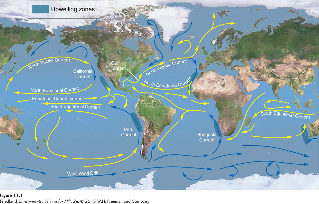
Gyres redistribute heat in the ocean, just as atmospheric convection currents redistribute heat in the atmosphere. Cold water from the polar regions moves along the west coasts of continents, and the cool air immediately above these waters brings cooler temperatures to the adjacent continents. For example, the California Current, which flows south from the North Pacific along the coast of California, causes coastal areas of California to have cooler temperatures than areas at similar latitudes on the east coast of the United States. Similarly, warm water from the tropics moves along the east coasts of continents, and the warm air immediately above these waters causes warmer temperatures on land.
Upwelling
Upwelling The upward movement of ocean water toward the surface as a result of diverging currents.
Ocean currents also help explain why some regions of the ocean support highly productive ecosystems. Along the west coasts of most continents, for example, the surface currents diverge, or separate from one another, causing deeper waters to rise and replace the water that has moved away. This upward movement of water toward the surface, shown as dark blue regions in FIGURE 11.1, is called upwelling. The deep waters bring with them nutrients from the ocean bottom that support large populations of producers. The producers, in turn, support large populations of fish that have long been important to commercial fisheries.
Deep ocean currents circulate ocean water over long time periods
Thermohaline circulation An oceanic circulation pattern that drives the mixing of surface water and deep water.
Another oceanic circulation pattern, thermohaline circulation, drives the mixing of surface water and deep water. This process is crucial for moving heat and nutrients around the globe. Thermohaline circulation appears to be driven by surface waters that contain unusually large amounts of salt. As FIGURE 11.1 shows, warm currents flow from the Gulf of Mexico to the very cold North Atlantic. Some of this water freezes or evaporates, and the salt that remains behind increases the salt concentration of the water. This cold, salty water is relatively dense, so it sinks to the bottom of the ocean, mixing with deeper ocean waters. Two processes—
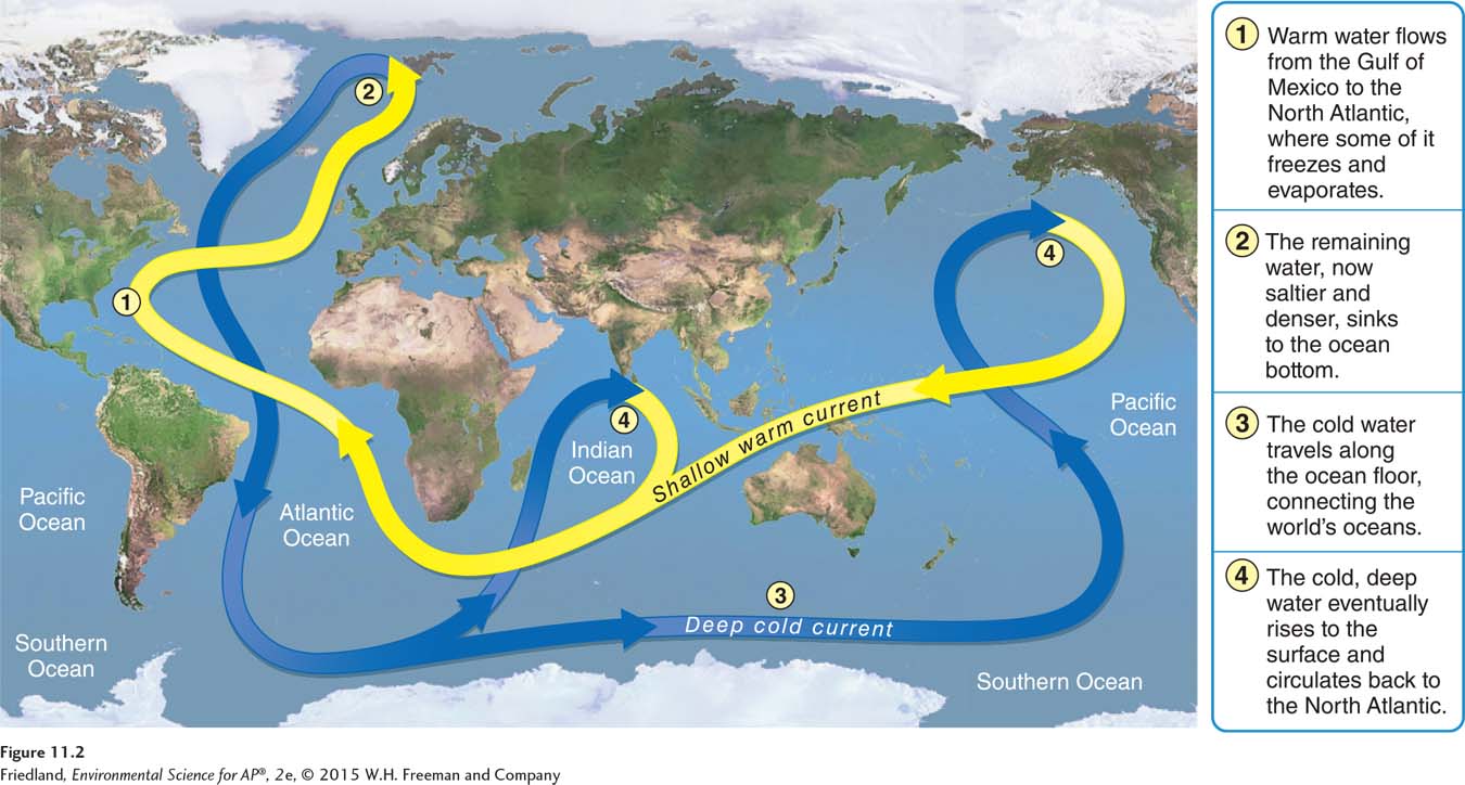
Ocean currents associated with thermohaline circulation affect the temperature of nearby landmasses much as the major gyres affect surface waters. For example, the ocean current known as the Gulf Stream originates in the tropics near the Gulf of Mexico and flows toward western Europe. This movement of warm tropical waters brings warmer temperatures to latitudes that would otherwise be much colder. For instance, England’s average winter temperature is 20°C (36°F) warmer than that of Newfoundland, Canada, which is located at a similar latitude but receives cold ocean currents from the North Atlantic.
Scientists are concerned that global warming could affect thermohaline circulation. If increased air temperatures accelerate the melting of glaciers in the Northern Hemisphere, the waters of the North Atlantic could become less salty and thus less likely to sink. Such a change could potentially shut down thermohaline circulation and stop the transport of warm water to western Europe, making it a much colder place.
The El Niño–Southern Oscillation is caused by a shift in ocean currents
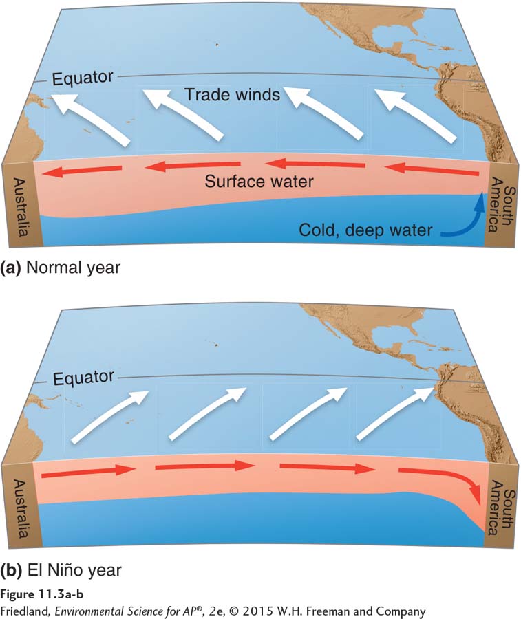
Our discussion of ocean currents has focused on the commonly occurring ocean currents. In the southern Pacific Ocean, for example, trade winds from South America and the Coriolis effect causes the equatorial water to flow from east to west. As we have discussed, this current produces an upwelling of cold, nutrient-
El Niño–
Every 3 to 7 years, however, the tropical current moves in the opposite direction. Because this phenomenon often begins around the December 25 Christmas holiday, it is has been named El Niño (“the baby boy”). However, since the cause of the phenomenon is due to a reversal of wind and water currents in the South Pacific, the preferred name for the phenomenon is the El Niño–
FIGURE 11.3 shows this process in action. First, the trade winds that normally blow from South America and push the surface waters to the west weaken or reverse direction. This change in the wind allows warm equatorial water from the western Pacific to move eastward toward the west coast of South America. The movement of warm water and air toward South America suppresses upwelling off the coast of Peru. The effect can last from a few weeks to a few years.
Because ocean currents are so important to global climates, the ENSO has several consequences. As we have noted, it reduces the upwelling off the South American coast, which decreases productivity and dramatically reduces fish populations. It also has widespread effects around the world, including cooler and wetter conditions in the southeastern United States and unusually dry weather in southern Africa and Southeast Asia.