3.4 Cloud Types
Identify and describe the major cloud types.
Clouds are a wonderful addition to the beauty of nature. They delight the eye in ever-
 Cloud formation is important for many reasons. Clouds delivers freshwater to the continents in the form of precipitation, and they play other crucial roles in Earth’s climate system as well. The Geographic Perspectives at the end of this chapter explores the relationship between clouds and climate further.
Clouds are composed of individual microscopic water droplets and ice crystals that are visible only when they are grouped together in large numbers. These particles are so light that they remain suspended by updrafts (vertical airflow).
cloud
An aggregation of microscopic water droplets and ice crystals suspended in the air.
Cloud Classification
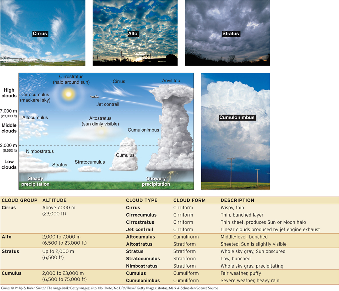
The cloud classification scheme used today was developed in 1803 by Luke Howard, an English naturalist. The World Meteorological Organization published the International Cloud Atlas in 1956 based on Howard’s classification scheme.
Following the system that is used to name living organisms, Howard employed Latin words to create three different groups of clouds based on their appearance: cirrus (wispy, feathered), cumulus (heaped, puffy), and stratus (layered). A later addition was the alto group, which, in the context of cloud names, means “middle.” Cirrus clouds are high clouds with a feathery appearance that are composed of ice crystals. Cumulus clouds are dome-
cirrus
A high cloud with a feathery appearance that is composed of ice crystals.
cumulus
A dome-
stratus
A cloud type characterized by low, flat sheets of clouds.
Nimbus (rain) is included in a cloud type name if the cloud produces precipitation. Later, Howard’s system was modified to include height categories. Cloud form categories are also used to describe and categorize clouds. Clouds take three basic forms: cirriform, stratiform, and cumuliform. All clouds can be described and categorized using these terms.
Nimbostratus clouds, for example, are low-
nimbostratus
Rain-
cumulonimbus
A cloud that extends high into the atmosphere and is capable of strong vertical development and of producing severe weather.
Fog
Have you ever wondered what it would be like to walk inside a cloud? Perhaps you already have. Fog is a stratus cloud on or near the ground that restricts visibility to less than 1 km (0.62 mi).
fog
A cloud at or near ground level that reduces visibility to less than 1 km (0.62 mi).
All types of fog form where air at Earth’s surface is cooled to the dew point. There are many kinds of fog, including orographic fog, freezing fog, and evaporation fog (see Picture This). The two most common types are radiation fog and advection fog.
Question 3.5
What is fog?
Fog is a cloud with a base that touches or is close to the ground.
Radiation fog (or valley fog) is fog that results as the ground radiates its heat away at night. The cooled ground cools the air above it. If the air temperature near the ground is lowered to the dew point, net condensation (and fog) will occur (Figure 3.24).
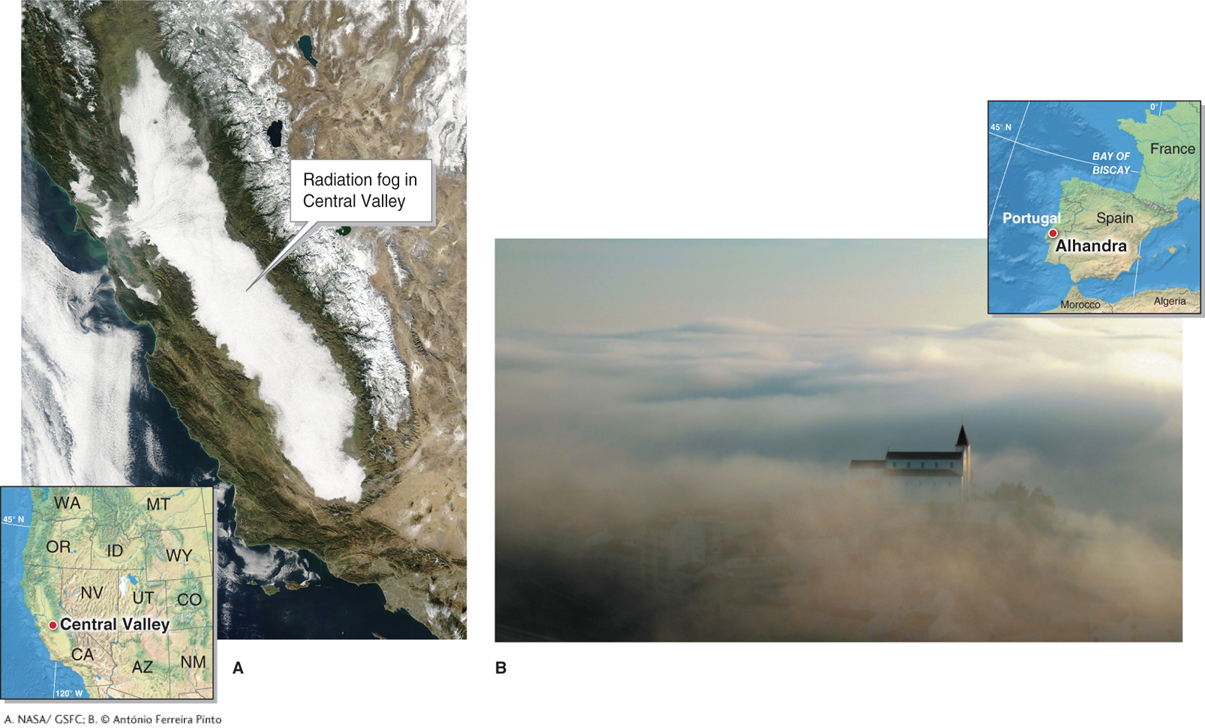
radiation fog
(or valley fog) Fog that results when the ground radiates its heat away at night, cooling the air above it to the dew point.
Unlike radiation fog, advection fog forms as moist air moves over a cold surface, such as a lake or a cold ocean current, and the air temperature is lowered to the dew point. Fog over the ocean is always advection fog. There is perhaps no better example of advection fog than that in San Francisco (Figure 3.25).

advection fog
Fog that results from moist air moving over a cold surface, such as a lake or a cold ocean current, that lowers its temperature to the dew point.