3.5 Precipitation: What Goes Up …

Name the different kinds of precipitation and explain how each forms.

One of the most important aspects of clouds is their ability to bring water to Earth’s continents. Without this water, life would exist only in the oceans. How does rain form and fall out of clouds?

Making Rain: Collision and Coalescence

The rain-making process starts with condensation nuclei: small particles, roughly 0.2 μm in diameter, that provide a surface on which water vapor can condense. Tiny bits of dust, bacteria, salt, smoke, pollen, volcanic ash, industrial pollution—all of these aerosols can act as condensation nuclei. In saturated air, water vapor condenses onto condensation nuclei to form cloud droplets.

condensation nuclei

Small particles in the atmosphere, about 0.2 μm in diameter, on which water vapor condenses.

condensation nucleus

A small particle in the atmosphere, about 0.2 μm in diameter, on which water vapor condenses.

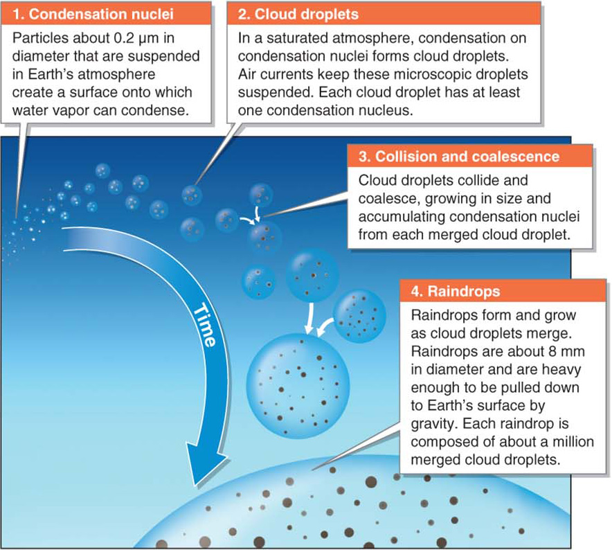
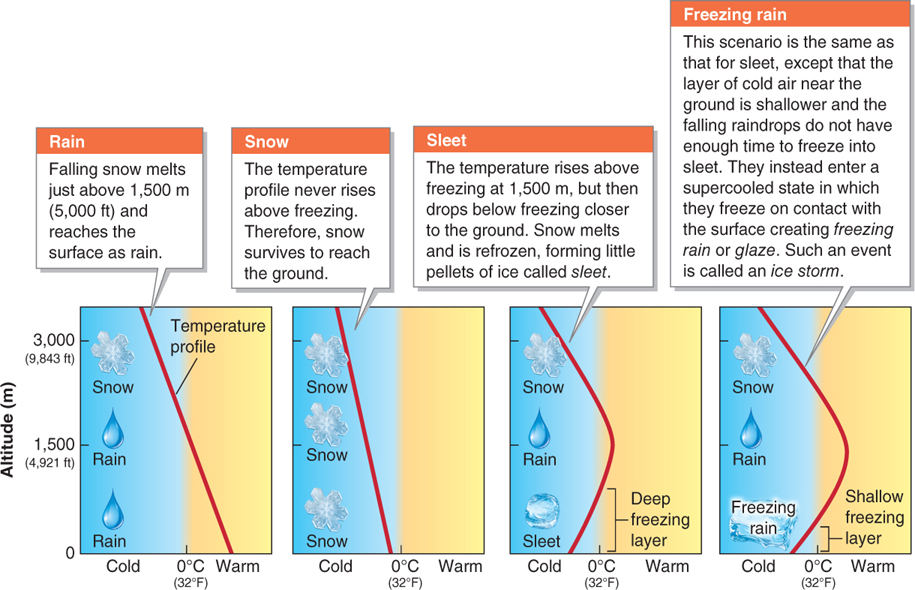
Collision and coalescence, the process by which cloud droplets merge to make raindrops (Figure 3.26), occurs in clouds at air temperatures of about –15°C (5°F) and warmer. When the raindrops become heavy enough, they fall to Earth. Referring back to Figure 3.5, without water’s cohesive property, cloud droplets would not form or merge, and there would be no rainfall.

Figure 3.26

GEO-GRAPHIC: The collision-and-coalescence process. A single raindrop forms from the collision and coalescence of many cloud droplets.

collision and coalescence

The process by which cloud droplets merge to form raindrops.

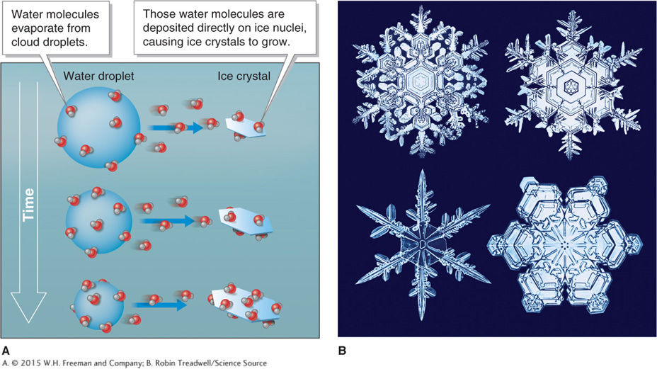
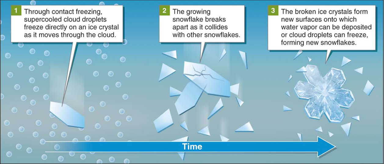
Normally, water freezes at 0°C (32°F), but the microscopic size of a cloud droplet allows it to enter a supercooled state rather than freezing at 0°C. In a supercooled state, water freezes quickly as it comes into contact with a solid object on the ground. Below about –10°C (14°F), a mixture of ice crystals and supercooled droplets occurs. Below about –40°C (or –40°F), all cloud droplets freeze. Supercooled cloud droplets are essential in the process of forming snow.

Making Snow: The Ice-Crystal Process

The ice-crystal process (or Bergeron process) forms snow in clouds in which the temperature is 0°C or below. Most winter precipitation at middle and high latitudes, where clouds are typically well below freezing, results from the ice-crystal process.

ice-crystal process

(or Bergeron process) The process by which ice crystals grow within a cloud to form snow.

The ice-crystal process is somewhat more complex and less well understood than the collision-and-coalescence process that forms raindrops. In general, there are two ways in which ice crystals grow to form snow. First, snow forms from water vapor as it is deposited directly on ice nuclei, as shown in Figure 3.27. Ice nuclei differ from condensation nuclei in that they are platelike or angular in shape. Salt crystals, some bacteria, and clay minerals are among the particles that can act as ice nuclei. In cold clouds, the saturation vapor pressure is slightly lower around ice crystals than it is around cloud droplets. Therefore, water vapor is deposited on an ice crystal more readily than it condenses on a cloud droplet. The second way snow forms is through contact freezing, shown in Figure 3.28.

Figure 3.27

Snow formation through deposition. (A) Snowflakes grow when water vapor, evaporated from supercooled cloud droplets, is deposited directly on an ice crystal, causing it to grow. (B) Snowflakes always grow as hexagons, reflecting the six-sided structure of the hydrogen bonds between water molecules (see Figure GT.7).
(B. Robin Treadwell/Science Source)

Figure 3.28

GEO-GRAPHIC: Snow formation through contact freezing.

112

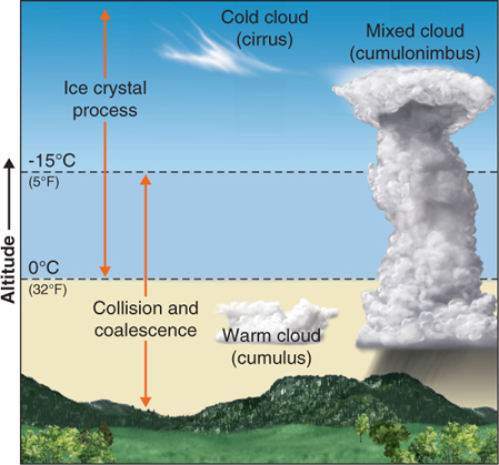
In warm clouds, the temperature is above 0°C, and the collision-and-coalescence process dominates. In cold clouds, the temperature is below 0°C throughout, and the ice-crystal process dominates. Clouds with a range of temperatures, and in which both processes occur, are called mixed clouds (Figure 3.29).

Figure 3.29

Warm, cold, and mixed clouds. Cumulus clouds are warm clouds. Cirrus clouds are cold clouds. Cumulonimbus clouds are mixed clouds.

113

Four Types of Precipitation

With the exception of hail, all types of precipitation are produced either through the collision-and-coalescence process or the ice-crystal process. Whether precipitation takes the form of rain, snow, sleet, or freezing rain depends on the temperature profile of the atmosphere—that is, the pattern of temperature change with altitude, as illustrated in Figure 3.30.

Figure 3.30

Temperature profiles and precipitation. These four different temperature profiles at different geographic locations result in four different types of precipitation.

The world record for greatest snowfall in a single season was set on Mount Baker, in Washington State, which received 28.96 m (95 ft) in the 1998–1999 season. How was that snow depth measured? There is an established protocol for measuring snow and rain. Some of the techniques used are outlined in Figure 3.31.

Figure 3.31

SCIENTIFIC INQUIRY How is precipitation measured? Water managers must measure precipitation amounts to prepare for potential droughts or floods. Precipitation measurements are also central to understanding how climate change may be affecting precipitation.
(Clockwise from top left: Photo by Ray Martin; National Weather Service Portland; AP Photo/Rich Pedroncelli; NASA/GSFC)

Hail Formation

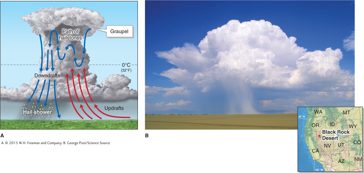
Hail is formed in cumulonimbus clouds with strong vertical airflow. Hail consists of hard, rounded pellets of ice, called hailstones, that precipitate out of cumulonimbus clouds. Hailstones start as small pellets of ice called graupel, which form as supercooled droplets of water freeze directly on snow crystals. As graupel is transported through the upper parts of a cumulonimbus cloud, where the temperature is below freezing. Raindrops and cloud droplets freeze onto it and add to its mass. Updrafts keep hailstones suspended in the cloud. The longer the growing hailstone remains aloft in the cloud, the larger and heavier it will grow. Therefore, the size of hailstones is related to the strength of updrafts in the cumulonimbus cloud (Figure 3.32).

Figure 3.32

Cumulonimbus clouds and hail. (A) Strong updrafts keep hailstones suspended in the cloud, allowing them to accumulate more ice. (B) This thunderstorm in the Black Rock Desert in Nevada is producing a deluge of heavy rain and hail. The hail is visible as the white curtain descending from the base of the cumulonimbus cloud.
(B. George Post/Science Source)

hail

Hard, rounded pellets of ice that precipitate from cumulonimbus clouds with strong vertical airflow.

114

115

Question 3.6

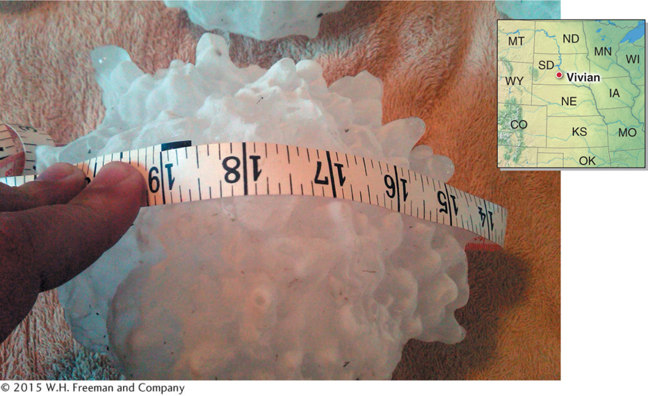
How big can hailstones get?

The world’s largest hailstone was nearly the size of a bowling ball. It fell in South Dakota in 2010.

Most hailstones are less than 2 cm (0.75 in) in diameter. Sometimes, however, they are much larger. In the late afternoon of July 23, 2010, in Vivian, South Dakota, the world’s largest officially recorded hailstone fell to Earth in a farm field (Figure 3.33). As recorded by a National Oceanic and Atmospheric Administration (NOAA) official, it measured 21.9 cm (8.63 in) in diameter—about the size of a bowling ball—and weighed 0.88 kg (1.94 lb).

Figure 3.33

World’s largest hailstone. The world’s largest officially recorded hailstone, which fell in Vivian, South Dakota, on July 23, 2010, weighed nearly 1 kg (2 lb).
(NOAA)

Hail destroys crops and property, costing taxpayers more than a billion dollars per year. Most of this damage comes as hail pits fruits and disfigures them, making them worthless on the market, or damages young plants. Large hailstones can be deadly. Hailstones the size of tennis balls or larger fall to Earth at about 160 km/h (100 mph).

116