4.1 Measuring and Mapping the Wind
Explain why the wind blows and how wind is measured and mapped.
Why does the wind blow? Wind is caused by air pressure differences that result from unequal heating of Earth´s surface and from the release of latent heat in clouds. As we learned in Chapter 2, the Sun’s energy heats Earth’s surface and atmosphere unequally. The tropics are heated more than the middle and high latitudes, and these differences in heating cause differences in air pressure. The outcome is the global heat engine (see Section 2.5) and atmospheric flow.
Latent heat is also an important cause of wind. As air parcels rise and cool to their dew point, water vapor condenses and releases latent heat (see Section 3.3). That latent heat warms the atmosphere and enhances atmospheric instability. As warm air rises, more air is pulled in along the ground, creating wind. Thunderstorms and hurricanes, for example, create wind in this manner.
Measuring the Wind
Wind speed is measured with an anemometer. Most anemometers are either cup anemometers or propeller anemometers. Both measure wind speed by the number of revolutions around a shaft per unit of time. Faster winds cause faster rotation of the shaft, which is calibrated to kilometers per hour (km/h), miles per hour (mph), meters per second (mps), or knots (kts). (A knot is equal to 1 nautical mile per hour, 1.86 km/h or 1.15 mph.) A wind vane (or weather vane) measures wind direction with a fin mounted on a vertical rod. The wind pushes the fin such that it always aligns with the wind. As shown in Figure 4.2, wind vanes and anemometers are often combined into a single instrument, an aerovane.
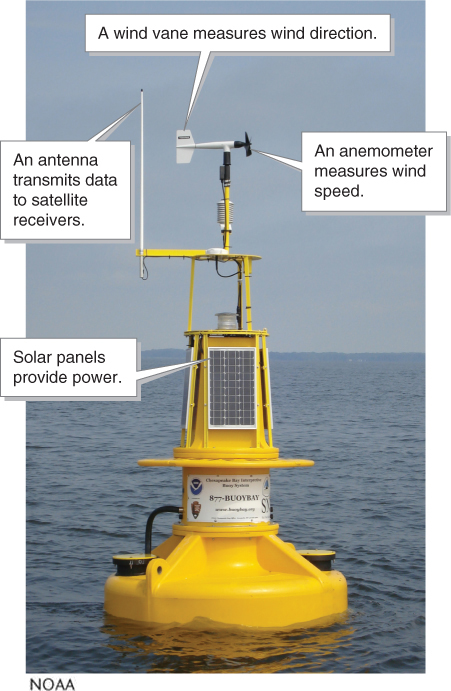
anemometer
(pronounced an-
wind vane
(or weather vane) An instrument used to measure wind direction.
aerovane
A combination of an anemometer and a wind vane; measures wind speed and direction.
The Beaufort wind force scale (or Beaufort scale) has long been used to rank wind speeds. The Beaufort scale is based on wind’s observed effects on objects, rather than on directly measured wind speeds (Table 4.1).
|
WIND FORCE |
DESCRIPTION |
WIND’S EFFECT |
WIND SPEED |
|
|---|---|---|---|---|
|
0– |
Calm |
Smoke rises straight up |
0– |
(0– |
|
2– |
Light breeze |
Leaves rustle and wind vane moves slightly |
5.6– |
(4– |
|
4– |
Moderate breeze |
Loose paper blows around |
20– |
(13– |
|
6– |
Strong breeze |
Open umbrellas are hard to hold and flip over |
39– |
(25– |
|
8– |
Gale |
Walking against the wind is extremely difficult |
62– |
(39– |
|
10– |
Storm (whole gale) |
Trees are uprooted |
89– |
(55– |
|
≥ 12 |
Hurricane force |
Widespread damage |
> 117 |
(> 73) |
Mapping the Wind
Once wind measurements have been taken, the data can be portrayed in several ways. Winds are named by their direction of flow. For example, a prevailing wind is the direction the wind blows most frequently during a specified window of time. An onshore wind is a coastal wind that flows from sea to land. In contrast, an offshore wind is a coastal wind that flows from land to sea, as illustrated in Figure 4.3.
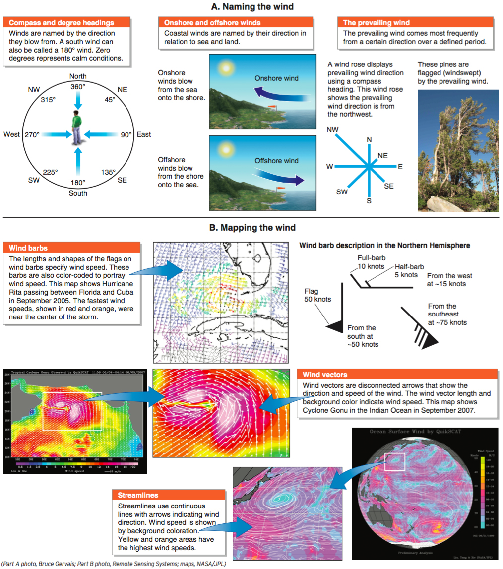
prevailing wind
The direction the wind blows most frequently during a specified window of time.
onshore wind
A coastal wind flowing from sea to land.
offshore wind
A coastal wind flowing from land to sea.