9.2 The Hidden Hydrosphere: Groundwater
Explain different features of aquifers and how water moves through the ground.
Soils and water are two closely tied natural resources that are essential to people. Soil is the medium that holds crop plants and natural vegetation, and water is required by all plants. This section begins by briefly exploring the connection between surface water and drought. It then examines water in the ground, both as a physical system and as a natural resource for people.
Every drop of water that we drink and, with the exception of seafood, every bite of food that we eat depends on the availability of freshwater. Most of Earth’s water is in the oceans. Only a small proportion is available to people as freshwater, and only a small proportion of that freshwater is available at Earth’s surface in streams and lakes (Table 9.2). Much of the water we rely on comes from underground.
|
All water |
|
All freshwater |
|
|---|---|---|---|
|
Oceans |
97.20% |
Glaciers |
2.15% |
|
Freshwater |
2.80% |
Groundwater |
0.62% |
|
|
|
Lakes |
0.017% |
|
|
|
Soil water |
0.005% |
|
|
|
Atmosphere |
0.001% |
|
|
|
Streams |
0.0001% |
Surface Water and Drought
The geographer Charles W. Thornthwaite (1899–
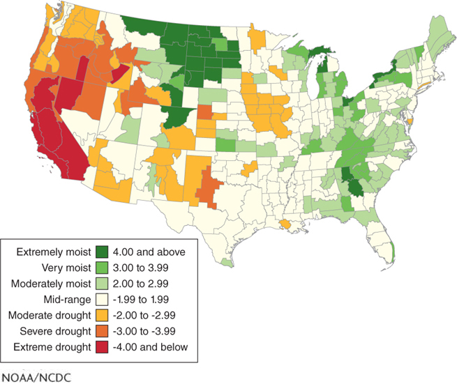
It is normal for deserts to have persistent water deficits. In other biomes, such as tropical deciduous forest or tropical savanna, water deficits are normal for only a few summer months of the year. When water deficits persist longer than normal as a result of a lack of precipitation, the result is a drought: a prolonged period of water shortage. The Palmer Drought Severity Index is a measure of dryness based mostly on potential evapotranspiration. This index is useful because it indicates the extent of drought occurring in an area (Figure 9.16).
drought
A prolonged period of water shortage.
What Flows Below: Groundwater
 Surface water in streams and lakes is a vitally important resource, but its availability fluctuates over weeks or months. Groundwater, on the other hand, acts as a buffer in times of drought. About half of the water people use in the United States comes from the ground. Groundwater is slower to respond to drought than surface water, but after several back-
groundwater
Water found beneath Earth’s surface in sediments and rocks.
How does water get into the ground, and what happens to it once it is there? The rest of this section explores this and other questions about groundwater.
Porosity and Permeability
When there is a water surplus, such as during a rainstorm or snowmelt, water moves through the soil through narrow, meandering channels by the process of percolation. Plants and evaporation pull some of this water out of the soil and return it to the atmosphere. Much of this water, however, migrates downward into the ground.
percolation
The process by which rainwater moves through the soil through narrow, meandering channels.
Groundwater flows into and through pores underground. Porosity is a measure of the available air space within soil, sediments, or rocks. Dry sand, for example, has high porosity. The porosity of the ground is expressed as a percentage. If half of a dry bucket of sand consists of open pores, then its porosity is 50%.
porosity
The available air space within sediments or rocks.
In most regions, significant stores of water do not exist much deeper than 0.8 km (0.5 mi) from the surface. At greater depths, the pressure from the weight of the ground compacts the pores, leaving little room for water.
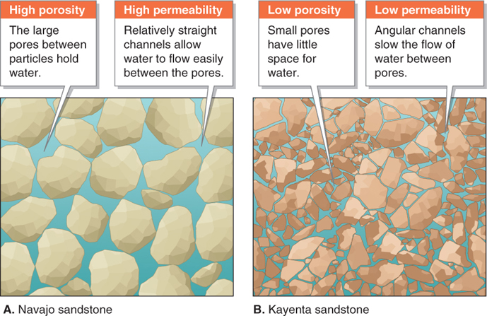
The rate at which water flows through pores within the ground varies from several centimeters to several meters per day. The ease with which water can flow through soil, sediments, or rocks is called permeability. The permeability of a material depends on the size, number, and configuration of pores within it. Permeability is high where there are many adjacent pores, creating straight paths for water flow.
permeability
The ease with which water can flow through soil, sediments, or rocks.
Sand is far more permeable than clay. Clay has many pores, but they are very narrow because clay particles are flat and platelike in shape. Like narrow streets in a city that restrict the flow of cars, the small and narrow connections between pores in clay restrict the flow of water. In other words, clay has high porosity (it can absorb water), but low permeability (water cannot pass easily through it). Different rock types have different porosities and permeabilities (Figure 9.17). Many rocks have no porosity and no permeability and therefore contain no water.
Groundwater in Aquifers
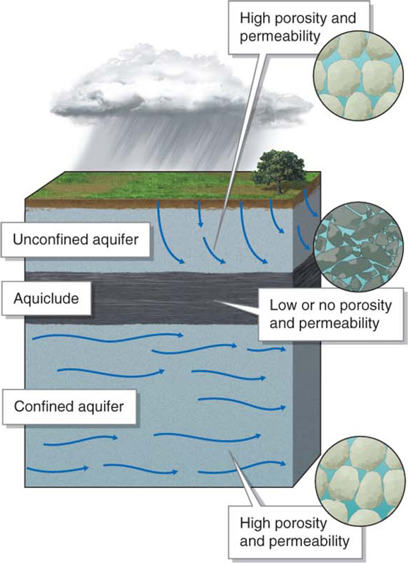
An aquifer is any sediment or rock with pores that contain water. Aquifers store and transmit water, and they are an important water resource for people in many arid regions. An aquiclude, in contrast, is a sediment or rock layer that lacks pores and cannot contain water. Aquicludes have low or no porosity or permeability. They greatly limit or altogether prevent water movement.
aquifer
A sediment or rock layer with pores that contain water.
aquiclude
A sediment or rock layer that lacks pores and cannot contain water.
Most aquifers are unconfined aquifers, meaning that rainwater can move into them directly from the surface. When an aquiclude separates an aquifer from the surface, the aquifer is a called a confined aquifer (Figure 9.18).
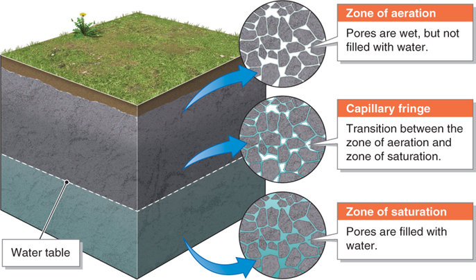
What would happen if you were to go out into your backyard with a shovel and dig a deep hole to the aquifer below? You would first dig through the aquifer’s zone of aeration, the layer of the ground that is not permanently saturated. If you kept digging, you would eventually reach the water table. The water table is the top surface of the aquifer’s zone of saturation, the layer of the ground usually saturated with water. You would not reach the water table abruptly, however. Instead, the soil would gradually become wetter and wetter as you approached the zone of saturation. Eventually, the hole might fill with a mud slurry just above the water table.
zone of aeration
The layer of the ground not permanently saturated with water.
water table
The top surface of an aquifer’s zone of saturation.
zone of saturation
The layer of the ground that is usually saturated with water.
This thought experiment demonstrates the structure of soil moisture above an aquifer. The ground becomes gradually wetter with digging because water is pulled up from the zone of saturation into the zone of aeration by capillary action and surface tension (both of which result from cohesion; see Section 3.1 on the properties of water). The gradual transition between the zone of aeration and the zone of saturation is called the capillary fringe (Figure 9.19).
capillary fringe
The region of transition between the zone of aeration and the zone of saturation.
Groundwater Movement
An unconfined aquifer’s water table is seldom level. The water table roughly parallels the height of the ground surface (Figure 9.20). The contours of the water table determine differences in hydraulic pressure (water pressure), and thus the direction of water movement, in the aquifer.
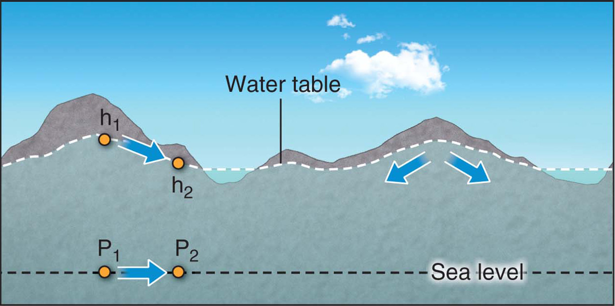
Why does the water table follow surface topography instead of being level like the surface of a pond? The process by which rainwater seeps into the ground through the force of gravity is called infiltration. When rain falls on areas of high elevation, the infiltrating water has a farther distance to travel downward. If no more rain were ever to fall, gravity would eventually create a level water table.
infiltration
The process by which water seeps into the ground through the force of gravity.
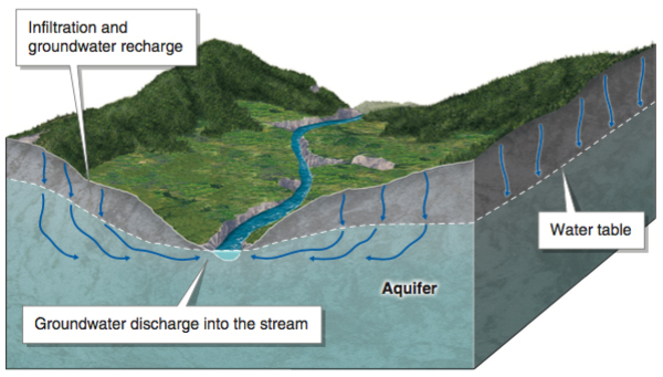
Infiltration results in groundwater recharge, the entry of water into an aquifer. The movement of water out of an aquifer and onto the ground surface is called groundwater discharge (Figure 9.21).
groundwater recharge
The movement of water into an aquifer.
groundwater discharge
The movement of water out of an aquifer.
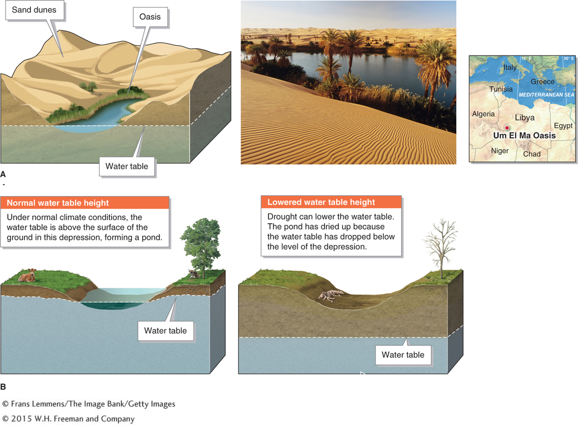
The Height of the Water Table
How far below the ground surface is the water table? In most cases, bodies of surface water, such as ponds or streams, represent the height of the water table. The water table may lie at the ground surface and form a lake or stream, or it may lie hundreds of meters below the surface.
In arid regions, the water table typically lies far below the surface of the ground because of the lack of precipitation and infiltration to fill the pores. As a result, there are few permanent surface streams or water bodies in most arid regions. Streams in these regions are often ephemeral or exotic: They flow only after sudden heavy precipitation events add water to the stream channel faster than it can infiltrate the ground.
At any given location, the water table is not fixed. It fluctuates because of seasonal changes in precipitation, water withdrawals from aquifers by people, and long-
Localized impermeable layers of rock or sediment, called discontinuous aquicludes, sometimes form perched water tables. A perched water table is a localized water table that lies above the regional water table (Figure 9.23).
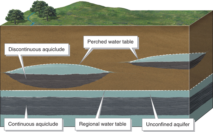
perched water table
A localized water table that lies above the regional water table.
Perched water tables sometimes create springs. A spring arises where hydraulic pressure pushes groundwater onto the surface. Springs may form along cliff faces and hillsides where water collects above a small, localized aquiclude, as shown in Figure 9.24.
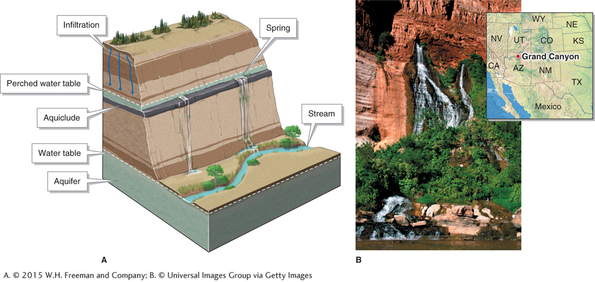
spring
A naturally occurring discharge of groundwater that is pushed to the ground surface by hydraulic pressure.
Hydraulic Pressure and the Potentiometric Surface
Have you ever wondered why water forcefully gushes out of your home’s faucets or garden hose? The hydraulic pressure pushing the water out is created by gravity. Our water supply is fed to our homes from a higher elevation, and the pull of gravity forces the water through the pipes that lead into our homes and faucets. In some places, the water supply flows from a reservoir located at an elevation higher than the buildings it supplies; in others, water is pumped mechanically into a water tower.
Question 9.5
Why does water in houses gush from the faucets?
Any house situated below the potentiometric surface of a nearby water source will have sufficient water pressure in the pipes to make the water gush from the faucets.
Water gushes from our faucets because our homes lie below the potentiometric surface created by the elevation of the water supply. The potentiometric surface is the elevation to which hydraulic pressure pushes water in pipes or wells. Any structures higher than the potentiometric surface will have no water pressure (Figure 9.25).
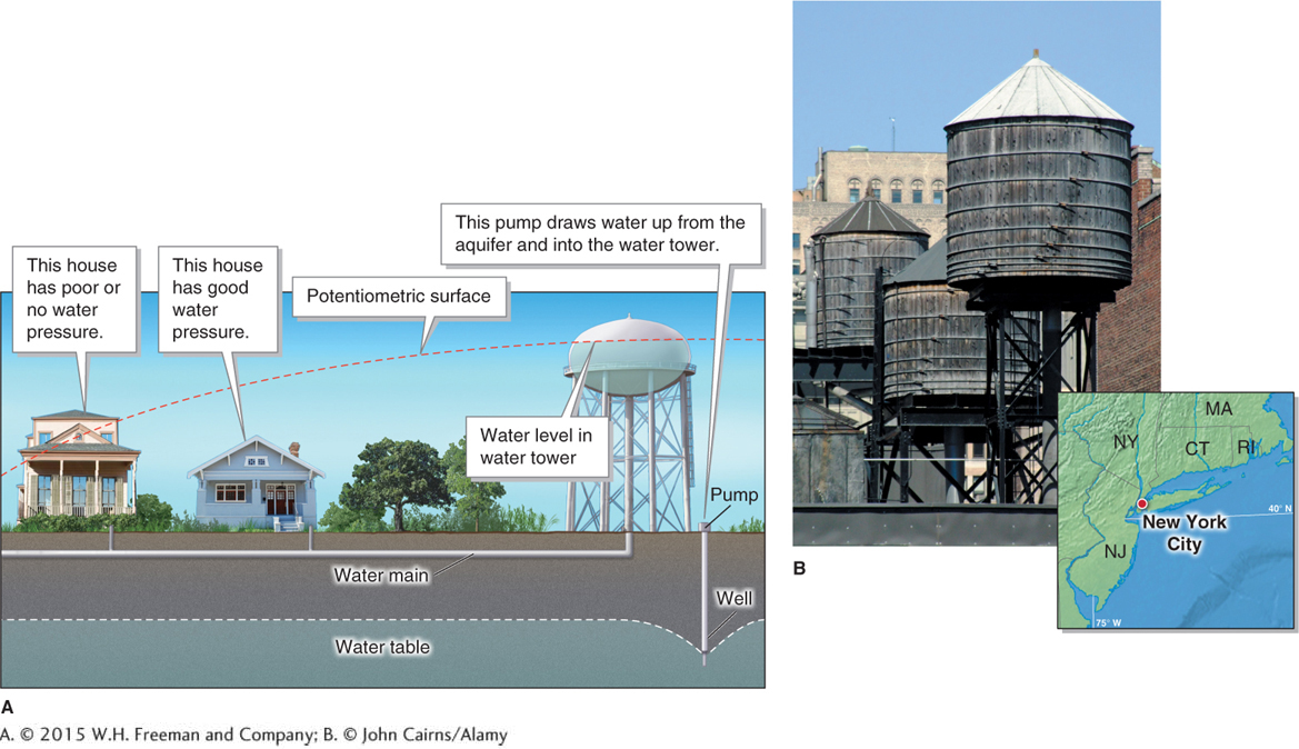
potentiometric surface
The elevation to which hydraulic pressure will push water in pipes or wells.
Wells are holes dug or drilled by people to get water from the ground. When a well is drilled downward into the zone of saturation, it will fill with water up to the height of the water table. The tops of most wells lie above the potentiometric surface of the aquifer, so pumps (or buckets) must be used to lift the water up out of the well. A well drilled down only as far as the zone of aeration will not produce water unless the water table rises to the well during the rainy or snowmelt season.
well
A hole dug or drilled by people to gain access to groundwater.
An artesian well is a well that has been drilled through an aquiclude into a confined aquifer below. Water gushes out of some artesian wells with no pumping required because they are below the potentiometric surface of the recharge area of the aquifer. Artesian wells may form where sedimentary rocks (see Section 13.3) are tilted and permeable and impermeable layers of rock intersect the ground surface, forming a confined aquifer. Rainwater flows into the permeable layers where they are exposed at the surface. Because the recharge area is higher in elevation than the aquifer, the recharge area creates hydraulic pressure that pushes water through the aquifer, much as a water tower pushes water through the pipes of a building (Figure 9.26).
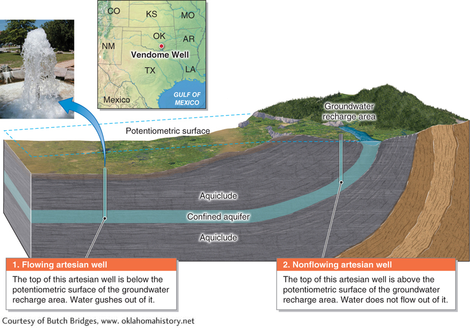
artesian well
A well that has been drilled through an aquiclude into a confined aquifer below and may gush water.