12.4 Hot Spots, Folding and Faulting, and Mountain Building
Describe landforms that result from tectonic processes away from plate boundaries.
There are two tectonic processes that do not fit into the three types of plate boundary interactions discussed in the previous section, but are nevertheless important in building landforms: hot spots and folding and faulting. In this section we describe those processes, and we summarize the tectonic processes that result in mountain building.
Hot Spots
So far, the types of volcanoes that we have discussed all occur at plate margins where divergence or subduction is occurring. But not all volcanoes occur on plate boundaries. There are some 30,000 islands in the Pacific Ocean, and most of them are volcanic islands that formed far from plate boundaries. Hawai‘i, Easter Island, Tahiti, and the Galápagos Islands are a few examples of non-
Volcanic islands such as these are the result of geologic hot spots. A hot spot is a location at the base of the lithosphere where high temperatures cause the overlying crust to melt. A hot spot results from a mantle plume, a mostly stationary column of hot solid rock that extends from deep in the mantle up to the base of the lithosphere (Figure 12.25).
hot spot
A location at the base of the lithosphere where high temperatures cause the overlying crust to melt.
mantle plume
A mostly stationary column of hot rock that extends from deep in the mantle up to the base of the lithosphere.
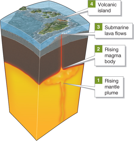
Mantle plumes are incompletely understood. They are thought to be rooted in Earth’s outer core, to remain mostly stationary, and to rise at a rate of several centimeters per year. The plumes are not liquid, but rather slowly deforming rock. As a hot spot approaches the lower lithosphere, a decrease in pressure lowers the rock’s melting point and allows it to melt into magma. The buoyant magma melts its way through the overlying crust, where it forms a volcano. As a lithospheric plate moves over a hot spot, a line of volcanoes may be formed (Figure 12.26).
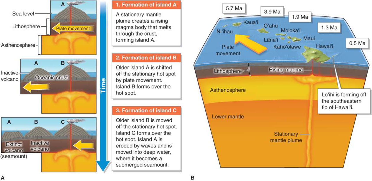
If you look carefully at a bathymetric map of the world’s ocean basins, you will find many linear ridges that look as if a giant knife had made long incisions in the crust. Volcanic islands and submerged seamounts are often associated with these linear ridges. Hot spots melt through the crust as the plates move over them, creating these lines of inactive volcanoes, called hot spot tracks (Figure 12.27).
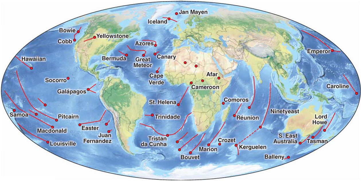
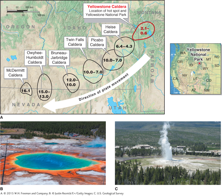
An active continental hot spot persists beneath the North American plate at the location of Yellowstone National Park. This hot spot has produced a number of volcanic eruptions, including one of Earth‘s largest known eruptions 640,000 years ago (see Section 14.2). It also produced a string of volcanic landforms called calderas (collapsed volcanoes) (Figure 12.28). Some scientists think that the magma body that resides just below Yellowstone National Park today could erupt again.
Bending and Breaking: Folding and Faulting
When hit with a hammer, rocks break into smaller fragments because they are brittle. When they are slowly compressed and heated, however, rocks in many cases are able to deform and fold (bend) before they fault (break). A fold is a wrinkle in the crust resulting from deformation caused by geologic stress, and a fault is a fracture in the crust where movement and earthquakes occur.
fold
A wrinkle in the crust resulting from deformation caused by geologic stress.
fault
A fracture in the crust where movement and earthquakes occur.
Folding and faulting can occur anywhere on Earth’s surface. Generally, folding occurs most often where two plates are converging, particularly in regions of subduction and collision. Faulting, too, occurs most often near plate boundaries, but many regions far away from plate boundaries are also faulted. Folding and faulting are particularly important elements of lithospheric plate movement because each can produce prominent surface landforms.
Folded Landforms
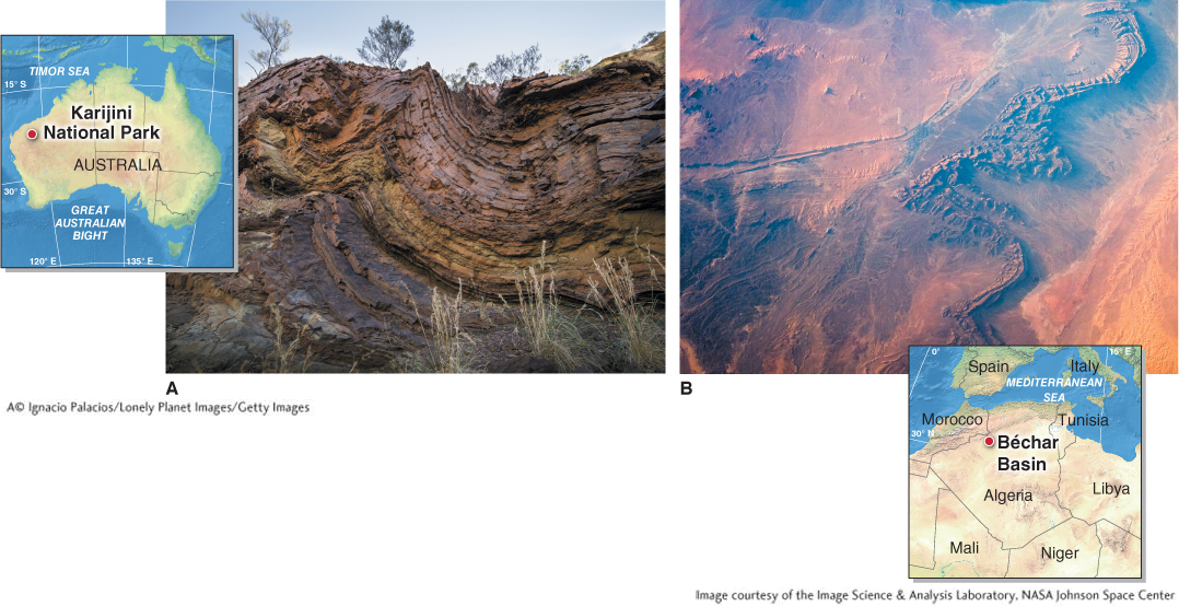
Many mountain ranges are the result of folding, which can occur anywhere compressional forces are pushing the crust together. Folds may also occur at just about any spatial scale, from centimeters to kilometers, and in nearly any rock type, as shown in Figure 12.29.
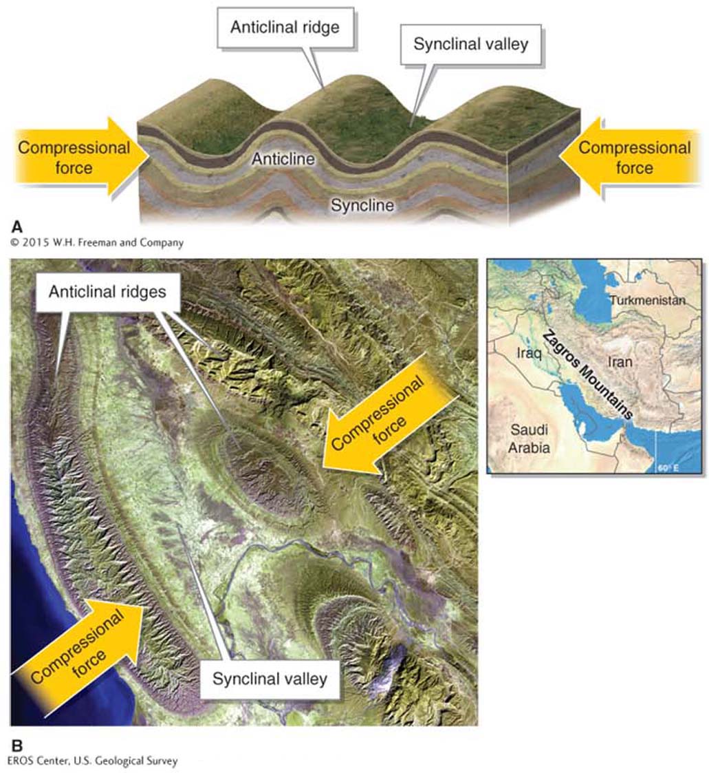
The two major types of folds are anticlines and synclines. An anticline is a fold in the crust with an archlike ridge, and a syncline is a fold in the crust with a U-
anticline
A fold in the crust with an archlike ridge.
syncline
A fold in the crust with a U-
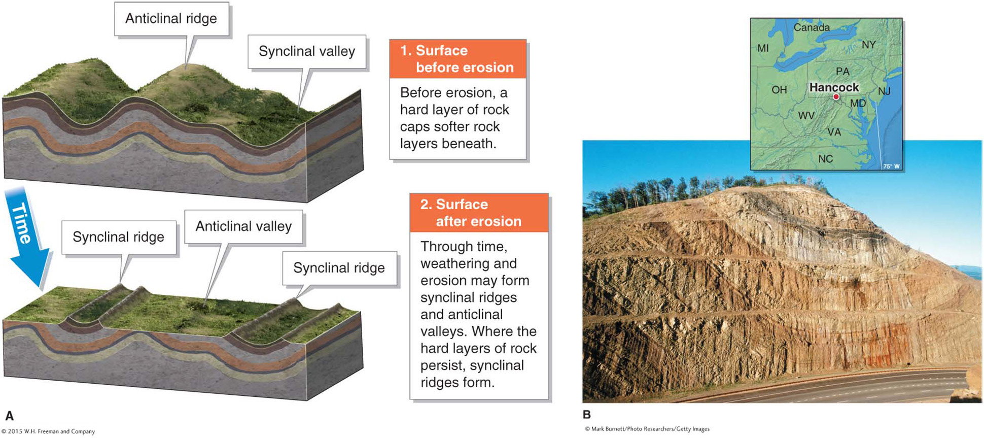
When a folded surface is eroded by streams, softer rock is often removed more quickly than harder rock, leaving the more resistant rock to form a ridge. This process can result in an inverted topography, with synclinal ridges and anticlinal valleys (Figure 12.31).
Block Landforms
Faulting results when rocks can deform no further by folding, and they break. When this happens, the energy stored in the rocks is released and travels through the crust as seismic waves that shake the ground in an earthquake. (Faulting and earthquakes are covered in greater detail in Section 14.3.)
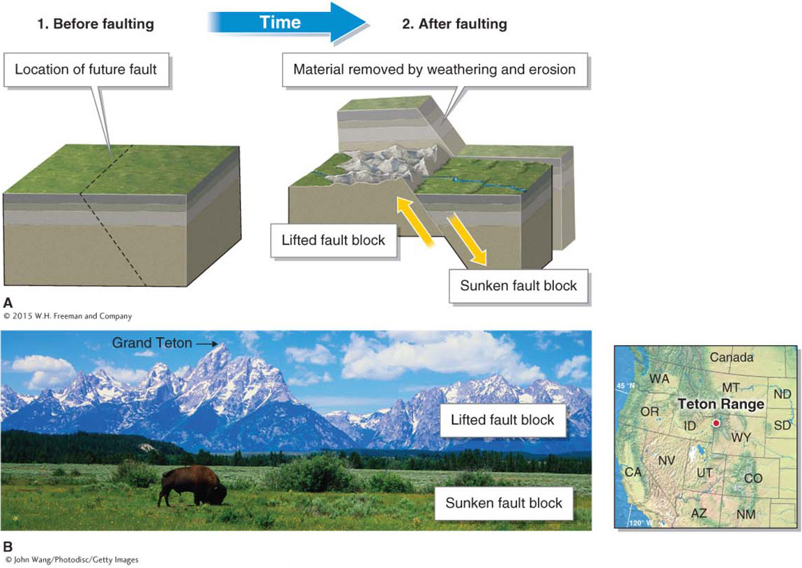
Through time, continued faulting can create blocks of crust that move vertically relative to each other. These blocks are called fault blocks. Like folds, fault blocks occur across many spatial scales and in a variety of tectonic settings. There are many fault-
Orogenesis: Tectonic Settings of Mountains
How do mountains form?
All of Earth’s mountain ranges were formed by different types of plate movement, although some do not lie at plate boundaries.
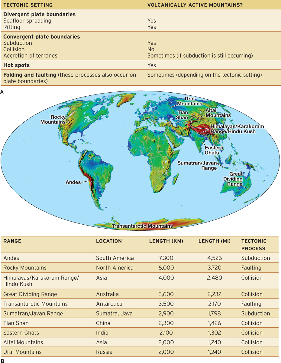
The building of mountain ranges by any tectonic process is called orogenesis (from the Greek oros, “mountain,” and genesis, “origin”). Most mountains are grouped together to form linear ranges. These ranges, called orogenic belts, form most commonly along plate boundaries, particularly in areas of collision and subduction. Away from plate boundaries, isolated mountains and orogenic belts form in areas of rifting, hot spot tracks, and folding and faulting. Figure 12.33 summarizes the tectonic settings and processes covered in this chapter and their roles in orogenesis.
orogenesis
Mountain building.
orogenic belt
A linear mountain range.
