America’s History: Printed Page 10
America: A Concise History: Printed Page 9
America’s History: Value Edition: Printed Page 10
Chiefdoms and Confederacies
Nothing on the scale of the Aztec and Inca empires ever developed north of Mexico, but maize agriculture spread from Mesoamerica across much of North America beginning around A.D. 1000, laying a foundation for new ways of life there as well.
The Mississippi Valley The spread of maize to the Mississippi River Valley around A.D. 1000 led to the development of a large-scale northern Native American culture. The older Adena and Hopewell cultures had already introduced moundbuilding and distinctive pottery styles to the region. Now residents of the Mississippi River Valley experienced the greater urban density and more complex social organization that agriculture encouraged.
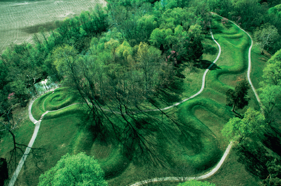
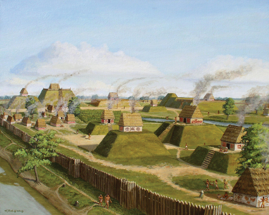
The city of Cahokia, in the fertile bottomlands along the Mississippi River, emerged around 1000 as the foremost center of the new Mississippian culture. At its peak, Cahokia’s population exceeded 10,000; smaller satellite communities brought the region’s population to 20,000 to 30,000. In an area of 6 square miles, archaeologists have found 120 mounds of varying size, shape, and function. Some contain extensive burials; others, known as platform mounds, were used as bases for ceremonial buildings or rulers’ homes. Cahokia had a powerful ruling class and a priesthood that worshipped the sun. After peaking in size around 1350, it declined rapidly. Scholars speculate that its decline was caused by an era of ruinous warfare, exacerbated by environmental factors that made the site less habitable. It had been abandoned by the time Europeans arrived in the area.
Mississippian culture endured, however, and was still in evidence throughout much of the Southeast at the time of first contact with Europeans. The Lady of Cofachiqui encountered by Hernando de Soto in 1540 ruled over a Mississippian community, and others dotted the landscape between the Carolinas and the lower Mississippi River. In Florida, sixteenth-century Spanish explorers encountered the Apalachee Indians, who occupied a network of towns built around mounds and fields of maize.
Eastern Woodlands In the eastern woodlands, the Mississippian-influenced peoples of the Southeast interacted with other groups, many of whom adopted maize agriculture but did not otherwise display Mississippian characteristics. To the north, Algonquian and Iroquoian speakers shared related languages and lifeways but were divided into dozens of distinct societies. Most occupied villages built around fields of maize, beans, and squash during the summer months; at other times of the year, they dispersed in smaller groups to hunt, fish, and gather. Throughout the eastern woodlands, as in most of North America, women tended crops, gathered plants, and oversaw affairs within the community, while men were responsible for activities beyond it, especially hunting, fishing, and warfare.
In this densely forested region, Indians regularly set fires — in New England, twice a year, in spring and fall — to clear away underbrush, open fields, and make it easier to hunt big game. The catastrophic population decline accompanying European colonization quickly put an end to seasonal burning, but in the years before Europeans arrived in North America bison roamed east as far as modern-day New York and Georgia. Early European colonists remarked upon landscapes that “resemble[d] a stately Parke,” where men could ride among widely spaced trees on horseback and even a “large army” could pass unimpeded (America Compared).
Algonquian and Iroquoian peoples had no single style of political organization. Many were chiefdoms, with one individual claiming preeminent power in a community. Some were paramount chiefdoms, in which numerous communities with their own local chiefs banded together under a single, more powerful ruler. For example, the Powhatan Chiefdom, which dominated the Chesapeake Bay region, embraced more than thirty subordinate chiefdoms, and some 20,000 people, by the time Englishmen established the colony of Virginia in Powhatan territory. Powhatan himself, according to the English colonist John Smith, was attended by “a guard of 40 or 50 of the tallest men his Country affords.”
Elsewhere, especially in the Mid-Atlantic region, the power of chiefs was strictly local. Along the Delaware and Hudson rivers, Lenni Lenape (or Delaware) and Munsee Indians lived in small, independent communities without overarching political organizations. Early European maps of this region show a landscape dotted with a bewildering profusion of Indian names. European colonization would soon drive many of these groups into oblivion and force survivors to coalesce into larger groups.
Some Native American groups were not chiefdoms at all, but instead granted political authority to councils of sachems, or leaders. This was the case with the Iroquois Confederacy. Sometime shortly before the arrival of Europeans, probably around 1500, five nations occupying the region between the Hudson River and Lake Erie — the Mohawks, Oneidas, Onondagas, Cayugas, and Senecas — banded together to form the Iroquois.
These groups had been fighting among themselves for years, caught in a destructive cycle of wars of retribution. Then, according to Iroquois legend, a Mohawk man named Hiawatha lost his family in one of these wars. Stricken by grief, he met a spirit who taught him a series of condolence rituals. He returned to his people preaching a new gospel of peace and power, and the condolence rituals he taught became the foundation for the Iroquois Confederacy.
Once bound by these rituals, the Five Nations began acting together as a political confederacy. They avoided violence among themselves and became one of the most powerful Native American groups in the Northeast. The Iroquois did not recognize chiefs; instead, councils of sachems made decisions. These were matriarchal societies, with power inherited through female lines of authority. Women were influential in local councils, though men served as sachems, made war, and conducted diplomacy.
Along the southern coast of the region that would soon be called New England, a dense network of powerful chiefdoms — including the Narragansetts, Wampanoags, Mohegans, Pequots, and others — competed for resources and dominance. When the Dutch and English arrived, they were able to exploit these rivalries and play Indian groups against one another. Farther north, in northern New England and much of present-day Canada, the short growing season and thin, rocky soil were inhospitable to maize agriculture. Here the native peoples were hunters and gatherers and therefore had smaller and more mobile communities, though they were no less complex than their agriculturally oriented cousins.
The Great Lakes To the west, Algonquian-speaking peoples dominated the Great Lakes. The tribal groups recognized by Europeans in this region included the Ottawas, Ojibwas, and Potawatomis. But collectively they thought of themselves as a single people: the Anishinaabe. Clan identities — beaver, otter, sturgeon, deer, and others — crosscut tribal affiliations and were in some ways more fundamental. The result was a social landscape that could be bewildering to outsiders. Here lived, one French official remarked, “an infinity of undiscovered nations.”
The extensive network of lakes and rivers, and the use of birchbark canoes, made Great Lakes peoples especially mobile. “They seem to have as many abodes as the year has seasons,” wrote one observer. They traveled long distances to hunt and fish, to trade, or to join in important ceremonies or military alliances. Groups negotiated access to resources and travel routes. Instead of a map with clearly delineated tribal territories, it is best to imagine the Great Lakes as a porous region, where “political power and social identity took on multiple forms,” as one scholar has written.
The Great Plains and Rockies Farther west lies the vast, arid steppe region known as the Great Plains, which was dominated by the hunting and gathering activities of small, dispersed groups. The geopolitics of the Plains Indians was transformed by a European import — the horse — long before Europeans themselves arrived. Livestock was introduced in the Spanish colony of New Mexico in the late sixteenth century, and from there horses gradually dispersed across the plains. Bison hunters who had previously relied on stealth became much more successful on horseback.
Indians on horseback were also more formidable opponents than their counterparts on foot, and some Plains peoples leveraged their control of horses to gain power over their neighbors. The Comanches were a small Shoshonean band on the northern plains that migrated south in pursuit of horses. They became expert raiders, capturing people and horses alike and trading them for weapons, food, clothing, and other necessities. Eventually they controlled a vast territory. From their humble origins, their skill in making war on horseback made the Comanches one of the region’s most formidable peoples.
Similarly, horses allowed the Sioux, a confederation of seven distinct peoples who originated in present-day Minnesota, to move west and dominate a vast territory ranging from the Mississippi River to the Black Hills. The Crow Indians moved from the Missouri River to the eastern slope of the Rocky Mountains, where they became nomadic bison hunters. Beginning in the mid-eighteenth century, they became horse breeders and traders as well.
In some places, farming communities were embedded within the much wider geographical range of hunter-gatherers. Thus the Hidatsa and Mandan Indians maintained settled agricultural villages along the Missouri River, while the more mobile Sioux dominated the region around them. Similarly, the Caddo Indians, who lived on the edge of the southern plains, inhabited agricultural communities that were like islands in a sea of more mobile peoples.
Three broad swaths of Numic-speaking peoples occupied the Great Basin that separated the Rockies from the Sierra Mountains: Bannocks and Northern Paiutes in the north, Shoshones in the central basin, and Utes and Southern Paiutes in the south. Resources were varied and spread thin on the land. Kin-based bands traveled great distances to hunt bison along the Yellowstone River (where they shared territory with the Crows) and bighorn sheep in high altitudes, to fish for salmon, and to gather pine nuts when they were in season. Throughout the Great Basin, some groups adopted horses and became relatively powerful, while others remained foot-borne and impoverished in comparison with their more mobile neighbors.
The Arid Southwest In the part of North America that appears to be most hostile to agriculture — the canyon-laced country of the arid Southwest—surprisingly large farming settlements developed. Anasazi peoples were growing maize by the first century A.D., earlier than anywhere else north of Mexico, and Pueblo cultures emerged around A.D. 600. By A.D. 1000, the Hohokams, Mogollons, and Anasazis (all Pueblo peoples) had developed irrigation systems to manage scarce water, enabling them to build sizable villages and towns of adobe and rock that were often molded to sheer canyon walls. Chaco Canyon, in modern New Mexico, supported a dozen large Anasazi towns, while beyond the canyon a network of roads tied these settlements together with hundreds of small Anasazi villages.
Extended droughts and soil exhaustion caused the abandonment of Chaco Canyon and other large settlements in the Southwest after 1150, but smaller communities still dotted the landscape when the first Europeans arrived. It was the Spanish who called these groups Pueblo Indians: pueblo means “town” in Spanish, and the name refers to their distinctive building style. When Europeans arrived, Pueblo peoples, including the Acomas, Zuñis, Tewas, and Hopis, were found throughout much of modern New Mexico, Arizona, and western Texas.
The Pacific Coast Hunter-gatherers inhabited the Pacific coast. Before the arrival of the Spanish, California was home to more than 300,000 people, subdivided into dozens of small, localized groups and speaking at least a hundred distinct languages. This diversity of languages and cultures discouraged intermarriage and kept these societies independent. Despite these differences, many groups did share common characteristics, including clearly defined social hierarchies separating elites from commoners. They gathered acorns and other nuts and seeds, caught fish and shellfish, and hunted game.
The Pacific Northwest also supported a dense population that was divided into many distinct groups who controlled small territories and spoke different languages. Their stratified societies were ruled by wealthy families. To maintain control of their territories, the more powerful nations, including the Chinooks, Coast Salishes, Haidas, and Tlingits, nurtured strong warrior traditions. They developed sophisticated fishing technologies and crafted oceangoing dugout canoes, made from enormous cedar trees, that ranged up to 60 feet in length. Their distinctive material culture included large longhouses that were home to dozens of people and totem poles representing clan lineages or local legends.
EXPLAIN CONSEQUENCES
Question
How did landscape, climate, and resources influence the development of Native American societies?