Earth’s continents and climates have changed over time
The globes and maps that adorn our walls, shelves, and books give an impression of a static Earth. It would be easy for us to assume that the continents have always been where they are. But we would be wrong. The idea that Earth’s land masses have changed their positions over the millennia, and that they continue to do so, was first put forth in 1912 by the German meteorologist and geophysicist Alfred Wegener. His idea, known as continental drift, was initially met with skepticism and resistance. By the 1960s, however, physical evidence and increased understanding of plate tectonics—the geophysics of the movement of major land masses—
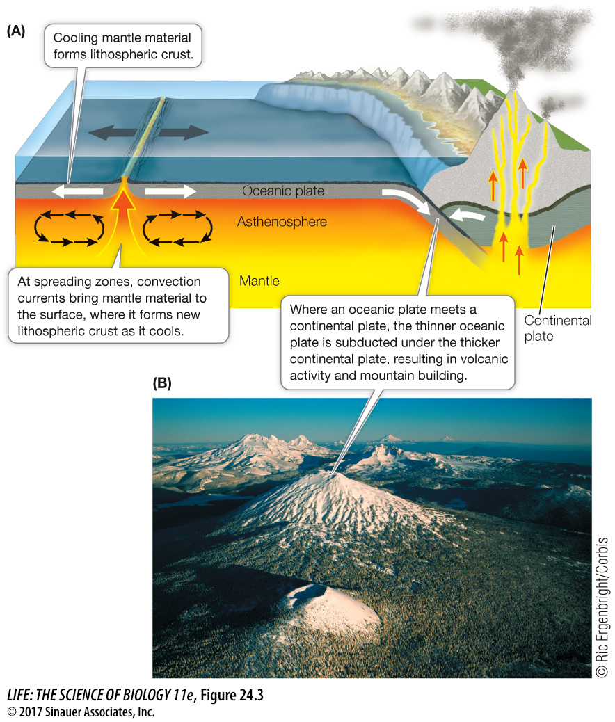
Earth’s crust consists of several solid plates, which collectively make up the solid lithosphere (“stone sphere”). Thick continental and thinner oceanic lithospheric plates overlie a viscous, malleable layer of Earth’s mantle, known as the asthenosphere (“weak sphere”). Heat produced by radioactive decay deep in Earth’s core sets up large-
Where oceanic plates and continental plates converge, the thinner oceanic plate is forced underneath the thicker continental plate, a process known as subduction. Subduction results in volcanism and mountain building on the continental boundary (Focus: Key Figure 24.3A). For example, in the Pacific Northwest of North America, a series of volcanoes formed the Cascade mountain range as the Juan de Fuca oceanic plate has been subducted beneath a portion of the continental North American Plate (Focus: Key Figure 24.3B). When two oceanic plates collide, one is subducted below the other, producing a deep oceanic trench and associated volcanic activity. The deepest part of the world’s oceans—
focus: key figure
Q: Why are both shores of the Pacific Ocean ringed with volcanic mountain ranges?
There is a spreading zone in the middle of the Pacific Ocean where new lithospheric crust is forming. This pushes the oceanic plates on either side to the east and west, forming subduction zones where oceanic plates meet continental plates on both sides of the Pacific Ocean.
Media Clip 24.2 Lava Flows and Magma Explosions
When two thick continental plates collide, neither plate is subducted. Instead, the plates push up against one another, forming high mountain chains. The highest mountain chain in the world, the Himalayas, was formed this way when the Indian Plate collided with the Eurasian Plate. When continental plates diverge, new crust forms in the intervening spaces, resulting in deep clefts called rift valleys in which large freshwater lakes typically form. The Great Rift Valley lakes of eastern Africa, including Lake Malawi (discussed at the opening of Chapter 22), were formed in this way. Two plates can also slide past one another, forming a transform fault boundary (such as the San Andreas Fault that produces violent seismic activity in parts of California).
Many physical conditions on Earth have oscillated in response to plate tectonic processes. We now know that the movement of the plates has sometimes brought continents together and at other times has pushed them apart, as seen in the maps across the top of Figure 24.14. The positions and sizes of the continents influence oceanic circulation patterns, global climates, and sea levels. Sea level is influenced directly by plate tectonic processes (which can influence the depth of ocean basins) and indirectly by oceanic circulation patterns, which affect patterns of glaciation. As climates cool, glaciers form and tie up water over land masses; as climates warm, glaciers melt and release water.
Animation 24.1 Movement of the Continents