Biogeographic regions reflect evolutionary isolation
Climate interacts with local abiotic features to influence where and how organisms live, but these are not the only factors determining where organisms are found. Evolutionary history—
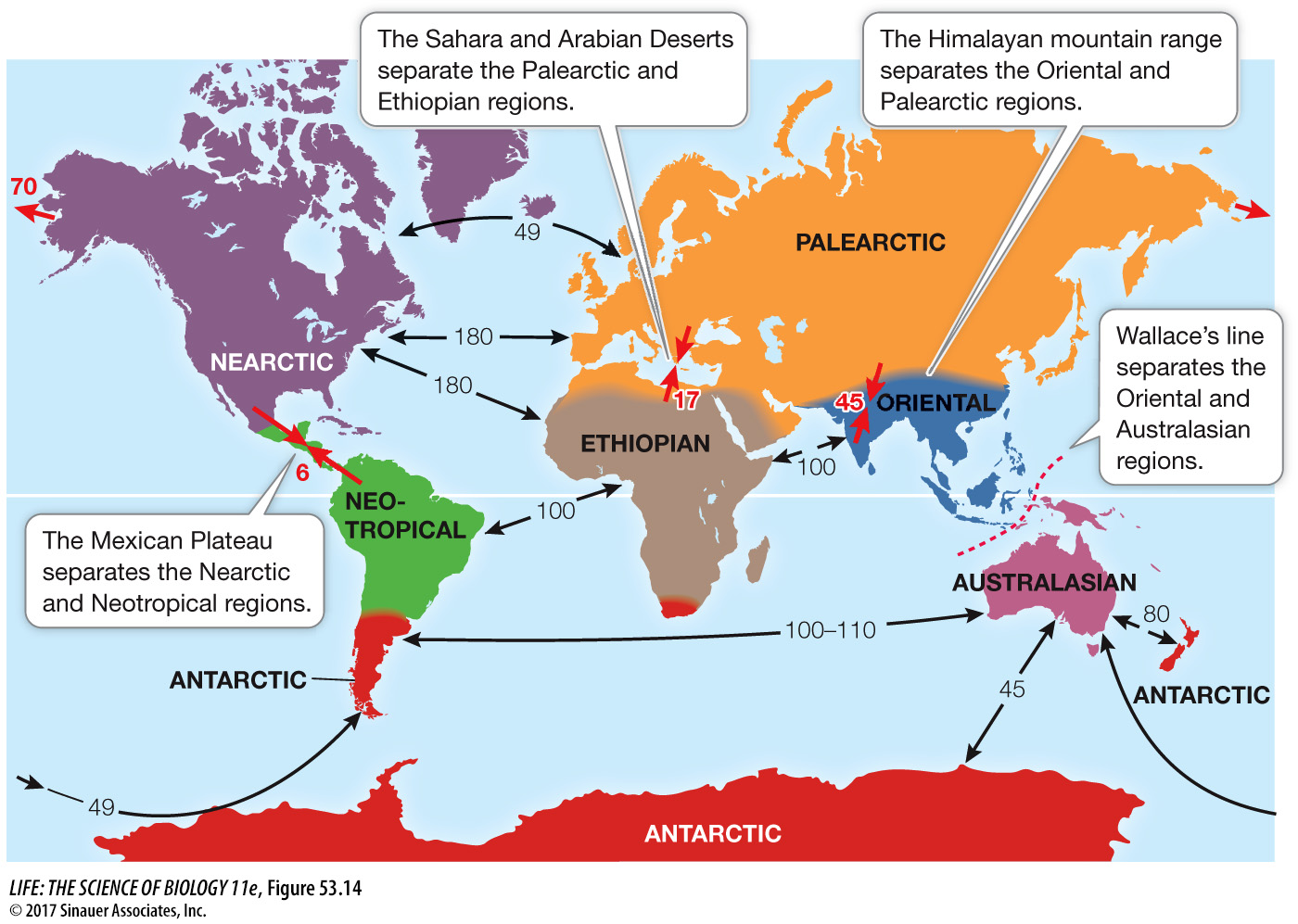
Until European naturalists traveled the globe in the nineteenth century, they had no way of knowing how organisms were distributed in other parts of the world. Alfred Russel Wallace, who along with Charles Darwin advanced the idea that natural selection could account for the evolution of life on Earth (see Key Concept 20.1), was one of those global travelers. Wallace spent seven years in the Malay Archipelago, where he noticed some remarkable patterns in the distributions of species. For example, he described the dramatically different species that inhabited the adjacent islands of Bali and Lombok. He pointed out that the differences could not be explained by the physical environment, because Bali and Lombok are only 24 kilometers apart.
Wallace saw that, based on the distributions of plant and animal species, he could draw a line that divided the Malay Archipelago into two distinct halves. He correctly deduced that the dramatic differences in flora and fauna were related to the depth of the channel separating Bali and Lombok. This channel is so deep that it would have remained full of water, and thus would have been a barrier to the movement of terrestrial animals, even during the glaciations of the Pleistocene epoch, when sea level dropped more than 100 meters and Bali and the islands to the west were connected to the Asian mainland.
With these insights, Wallace established the conceptual foundations of biogeography. In The Geographical Distribution of Animals, published in 1876, he detailed the factors known at the time that influence the distributions of animals, including past glaciation, land bridges, deep ocean channels, and mountain ranges. He earned some measure of scientific immortality in that the Malay discontinuity that first piqued his curiosity is known to this day as “Wallace’s line” (see Figure 53.14 below).
Q: As land masses separated, would you expect speciation to increase? Explain.
One would expect speciation to increase as land masses separated because species would become reproductively isolated from one another, thus increasing the chance that they could follow different evolutionary trajectories. The separation of species in this way is known as vicariance.
Activity 53.3 Major Biogeographic Regions
The biotas of different parts of the world differ enough to allow us to divide Earth into many continental-
*connect the concept Earth’s land masses have undergone continental drift over the millennia as a result of plate tectonics, shaping the major patterns of biogeography today and in the past. See Key Concepts 24.2 and 24.3.
The evolutionary separation of species can be attributed to two basic processes, vicariance and dispersal. Vicariance occurs when a physical barrier prevents dispersal and divides a species into two or more discontinuous populations. Dispersal occurs when the members of a species cross an existing barrier and establish a new population elsewhere.
Given that the processes of vicariance and dispersal both influence distribution patterns, how can biogeographers determine the role of each process when reconstructing the evolutionary history of a particular species? As you saw in Chapter 21, taxonomists have developed powerful molecular methods of reconstructing the phylogenetic relationships among organisms that can be used to understand how organisms came to occupy their present-
Media Clip 53.1 Rafting to Madagascar