Earth is a sphere, creating latitudinal variation in global temperature and precipitation
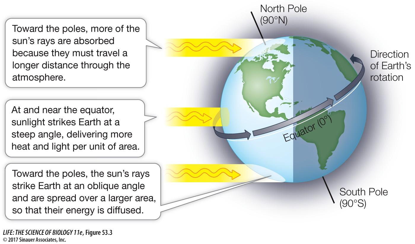
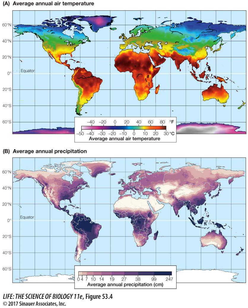
Because Earth is a sphere, the intensity of solar radiation hitting its surface varies with latitude. This latitudinal variation in solar energy depends primarily on the angle of the sun’s rays striking Earth. At high latitudes (i.e., areas toward the North and South poles), incoming solar energy is distributed over a larger area (and thus is less intense) than at the equator, where sunlight strikes the surface perpendicularly (Figure 53.3). Moreover, when the sun’s radiation comes in at an angle, it must pass through more of Earth’s atmosphere, resulting in more of its energy being absorbed or reflected before reaching Earth’s surface. Differences in solar energy input explain why the average global temperature varies with latitude, with warmer temperatures at the equator and colder temperatures at the poles (Figure 53.4A). The average air temperature over the course of a year decreases about 0.76°C for every degree of latitude (about 110 km) at sea level.


In addition to there being a latitudinal variation in temperature, the Northern Hemisphere is slightly warmer (by ~2°C) and more variable in temperature (by a of range ~7°C) than the Southern Hemisphere (see Figure 53.4A). Although the reasons for this difference are uncertain, one hypothesis is that because land heats up the air above it more than does the ocean (which absorbs more heat), the greater proportion of land to ocean in the Northern Hemisphere creates warmer air temperatures than those in the Southern Hemisphere. This is particularly true in summer, when the temperature difference is at its greatest. In light of global warming, it is worth noting that temperatures are increasing faster in the Northern Hemisphere than in the Southern Hemisphere.
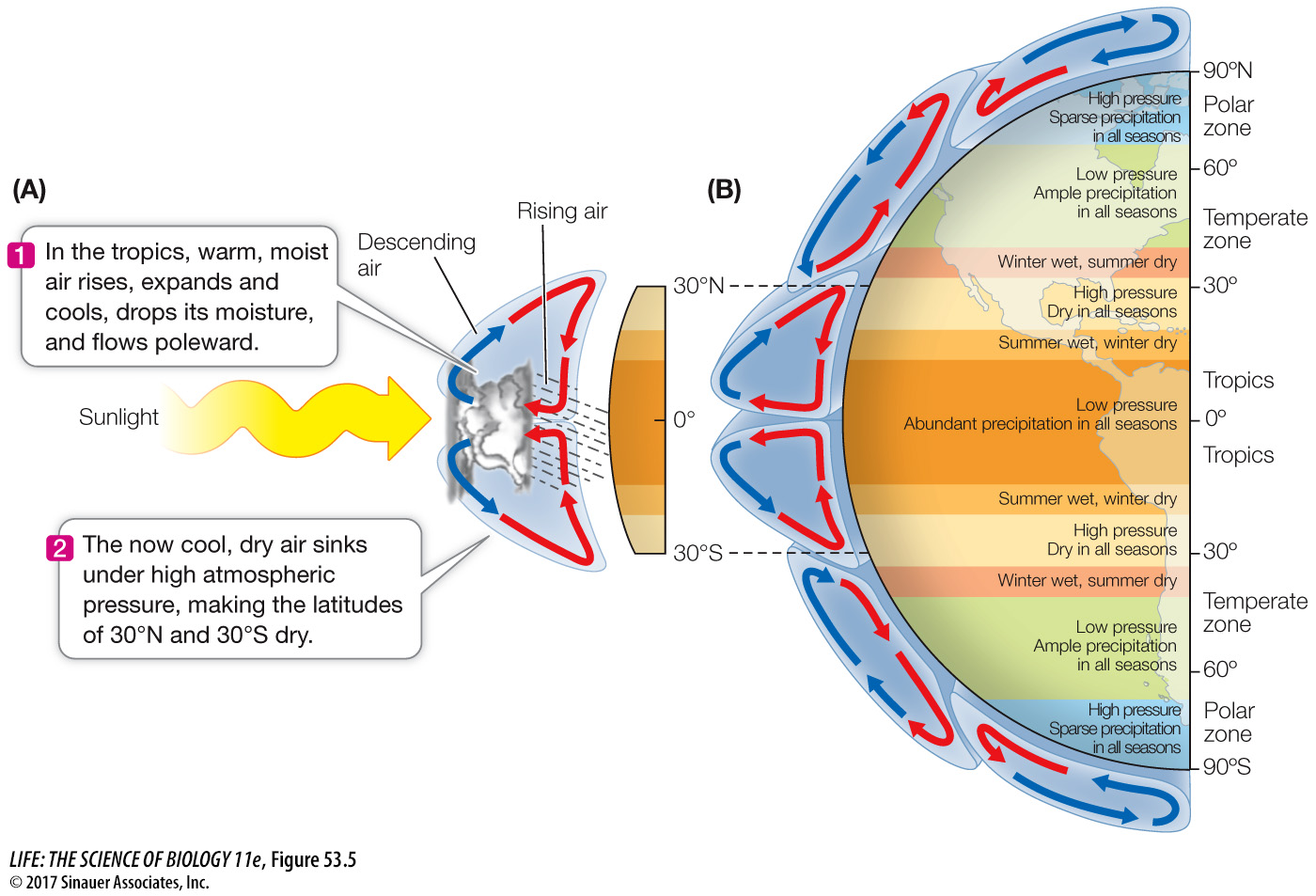
Besides controlling temperature, solar energy input also determines atmospheric circulation and associated precipitation patterns. As you saw earlier, air in the region surrounding the equator receives the greatest input of solar energy. When a parcel of air is warmed, it expands, becomes less dense, and rises (see Figure 53.5A). As it rises, however, it starts to cool at higher elevations. Cool air cannot hold as much water vapor as warm air, so the expanding, cooling air releases moisture in the form of precipitation. This is particularly evident in the tropics, where there is abundant rainfall year-

While some of the descending air flows back toward the equator, some of it flows toward the poles, setting up another atmospheric cell of air circulation at higher latitudes. At about 60° latitude, air rises again due to its warming at Earth’s surface (see Figure 53.5B). As this air rises, it cools and releases precipitation, creating wet climate conditions at temperate latitudes. Eventually this air reaches the stratosphere and moves north or south. The cold, dry air traveling at higher latitudes eventually reaches the cold polar region, where it descends. Despite the amount of snow and ice at the poles, high latitudes at or near 90° actually receive little precipitation and can be thought of as “polar deserts” (see Figure 53.4B).