Chapter 53
RECAP 53.1
Ecology is the study of the interrelationships among organisms and the physical environment, while environmentalism is the use of that ecological knowledge (as well as social and ethical concerns) to inform personal and public policy related to stewardship of the natural world. Ecology is a useful scientific enterprise because it can allow us to better anticipate how our actions may have negative consequences for ourselves and the natural world.
You could conduct observational surveys in the field to look for disease prevalence in live and dead sea stars. If multiple individuals were surveyed at multiple sites, then you might be able to make inferences of the prevalence of the disease at population and metapopulation scales. You could conduct an experiment in which you expose sea stars to the suspected pathogen to determine if they contract and die from the disease. Finally, you could create a population model to simulate how death from the disease would affect the populations of sea stars and compare the results with your observational data.
RECAP 53.2
No. A month of extremely hot weather does not necessarily tell us that Earth’s climate is warming. Climate is the long-
term average of atmospheric conditions over years to millennia. Because Earth is a sphere, the intensity of solar radiation hitting its surface varies with latitude. At high latitudes, incoming solar energy comes in at an angle and has to travel through more of the atmosphere than at the equator, making it less intense than at the equator, where sunlight strikes the surface perpendicularly. The consequence of this latitudinal variation in energy input is a major difference in temperature and precipitation at every 30° latitude. At the equator, climate is tropical with warm and wet conditions. At 30° N and S, climate is warm and dry, producing desert conditions. At 60° N and S, climate is temperate with cold and wet conditions. At the poles, climate is cold and dry.
If you were sailing from New York to the United Kingdon (west to east), you would want to use the Westerlies and the Gulf Stream to your advantage. Thus you would want to sail in a northeastern direction across the Atlantic Ocean. If you were sailing from San Francisco to Japan, you would want to take advantage of the NE Trade Winds and the North Equatorial Current in the Pacific Ocean.
Earth’s axis is tilted, changing the amount of sunlight a particular region receives over the course of a year as Earth orbits the sun. When the Northern Hemisphere is tilted toward the sun, it experiences summer conditions, but that means that the Southern Hemisphere is tilted away from the sun and experiences winter conditions.
RECAP 53.3
Mountain ranges and valleys can create local and regional differences in temperature and precipitation due to their effects on atmospheric circulation. They also influence the flow of fresh water in rivers and lakes. The topography of the seafloor creates variations in water depth, which affects light penetration, water temperature, water pressure, and water movement (i.e., currents, waves, and tides). These changes in physical conditions create different zones containing characteristic biota, which are similar to terrestrial biomes on land.
Cities are warmer because concrete, asphalt, and the dark roofs of buildings absorb heat from solar radiation and radiate that heat in the evening hours. Cities also produce more heat through the burning of fossil fuels from cars, factories, and buildings. The temperature differential between cities and the surrounding countryside can create “country breezes,” air movement generated as rising warm air from the city is replaced by cold surface air from surrounding rural areas. Parks can serve to cool the surrounding air through the evapotranspiration of trees and other vegetation.
RECAP 53.4
Biomes are characterized using information about the growth forms of their dominant plants, which reflect the evolution of those plants under annual patterns of temperature and precipitation. Tropical rainforests are found in equatorial regions where conditions are consistently wet and warm. The dominant vegetation is tropical trees, with up to 500 species per square kilometer. Temperate evergreen forests, by contrast, grow at middle to high latitudes, where winters are mild and wet and summers are cool and dry. The dominant trees are a handful of conifer species. The two forest types are similar in that they thrive under wet conditions and do not lose their leaves or needles on a seasonal basis.
Wallace saw dramatically different terrestrial species inhabiting the adjacent islands of Bali and Lombok, even though they were separated by 24 kilometers and had similar physical environments. This observation led him to hypothesize that different biota had been separated by a barrier (in this case, a deep channel), which kept them apart over evolutionary time. Wallace surmised that biogeographic regions are the result of the isolation that species experienced by residing on different continents or islands.
The fact that ice sheets extended into temperate regions, where species diversity is currently lower than in the tropics, better supports the species diversification time hypothesis. This hypothesis proposes that the amount of time in which speciation has taken place is greater in the tropics, where severe climate conditions did not slow down speciation or increase extinction. Thus the tropics have accumulated more species over time simply because of the lack of dramatic changes in climate.
RECAP 53.5
The premise of island biogeography is that the number of species on an island represents a balance between the immigration rate and the extinction rate. A far-
away island will have fewer immigrants than an island close to the species pool. In addition, a smaller island will have fewer resources, and thus sustain fewer species and have higher extinction rates. Larger islands provide greater resources and can sustain larger populations (which tend to have lower extinction rates than small populations). Habitat fragmentation essentially creates isolated islands of habitat surrounded by unsuitable habitat. The smaller and more isolated the habitat fragment, the fewer species that can be supported within the habitat and the less likely it is that species can move to more suitable fragments. In addition, the fragment can be exposed to edge effects—
hazards outside the habitat fragment that effectively reduce its size. Leaving habitat fragments that are large enough to sustain species can reduce the effects of habitat fragmentation or by creating corridors that species can use to move safely from one fragment to another. Page A-56WORK WITH THE DATA, P. 1164
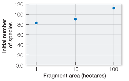
Yes, there is a positive relationship between number of bird species and size of the fragment area.
The scaling factor shows that to increase the t50 (i.e., the time it takes fragments to lose half their species) by 10-
fold, the fragment area would need to increase 1,000- fold. Thus, if t50 for 1 hectare = 5 years, the fragment would need to be 1,000 hectares to ensure that half the species would remain after 50 years. The fragment would need to be 10,000 hectares to ensure that half the species would remain after 100 years. Yes, because the average area would need to be 10,000 hectares to ensure that half the species would remain after 100 years.
FIGURE QUESTIONS
Figure 53.2 An increase in greenhouse gases increases the flux of infrared radiation back to Earth’s surface and has a warming effect on climate.
Figure 53.9 Temperature inversions occur when there are large temperature extremes that produce afternoon heat and morning cold. A valley concentrates heat from the sun during the day, and as the heat rises, it forms a layer of warm air (an inversion layer). The inversion layer traps cold, dense, and moisture-
Upwelling occurs when prevailing winds blow parallel to the coastline, displacing surface water away from the shoreline and thus allowing deep, cold water to rise to the surface. This cold water can cool moist air on the coast, creating morning fog.
Figure 53.12 All the species that are limited to a region are part of the regional species pool. Thus the regional species pool can influence species diversity and composition from the regional to local scales.
Figure 53.13 The northern hemisphere has more biome types. This is likely a consequence of the northern hemisphere having much more land area than the southern hemisphere, creating the opportunity for a diversity of temperature and rainfall regimes.
Figure 53.14 One would expect speciation to increase as land masses separated because species would become reproductively isolated from one another, thus increasing the chance that they could follow different evolutionary trajectories. The separation of species in this way is known as vicariance.
APPLY WHAT YOU’VE LEARNED
According to Figure B, the ability of reef fish species to respond to loss of corals is inversely proportional to the number of coral species present. The results show that fish from more diverse areas (PNG) were more sensitive to changes in the number of coral species than were fish from lower diversity areas (GBR, FP). This tendency for fish species to decline under lower coral diversity situations is a consequence of the fact that more diverse reefs contain more specialized fish species (species that depend for food and/or shelter on one or a very few coral species). These results suggest that if managers want to protect the most fish species possible, they should focus their efforts on the most diverse coral reefs where these specializations occur.
The PNG and GBR sites are relatively close together. Thus it would be easier for organisms, such as fish and coral larvae, to move between and colonize these sites. These colonization events could serve to increase species diversity at each site. The FP site is very isolated, and the probability of new species from the other sites reaching this area is much lower.
The PNG site is very near the equator, so it has a warm, stable environment. One theory that could explain species diversity as it relates to latitude is the species diversification time hypothesis. Equatorial species have had a very long time to evolve, unaffected by conditions (such as glaciation) that caused extinctions at higher latitudes. The other sites are slightly farther from the equator, which might make them slightly less likely to reach high levels of diversity. Another explanation might be the theory of island biogeography and the related concept of species–
area relationship. That is, higher species diversity is associated with greater land area, and isolated islands will show decreasing numbers of species with increasing distance from a source of new species. Although both PNG and GBR are islands, both sites are close to other islands and to a large landmass (Australia), making them likely to be colonized by species from these areas. The FP site is much more isolated and therefore much less likely to be colonized. As climate change progresses, coral reefs are likely to degrade and show local extinctions of coral species. The experiment shows that reefs with higher coral diversity are likely to have greater declines in fish species number as well. Thus, if climate change continues on its present course and coral reefs continue to decline in the future, the reefs that remain will likely have lower fish species diversity. Because areas with high coral diversity have more specialized fish species, these species will be most at risk. PNG—
and to a lesser extent GBR— will likely lose specialized fish species. FP, which is more isolated and has a lower coral diversity, will likely lose fewer (or no) fish species.