A History of Western Society: Printed Page 433
A History of Western Society, Value Edition: Printed Page 418
A History of Western Society, Concise Edition: Printed Page 434
Technology and the Rise of Exploration
The Iberian powers actively sought technological improvements in shipbuilding, weaponry, and navigation in order to undertake successful voyages of exploration and trade. Medieval European seagoing vessels consisted of single-
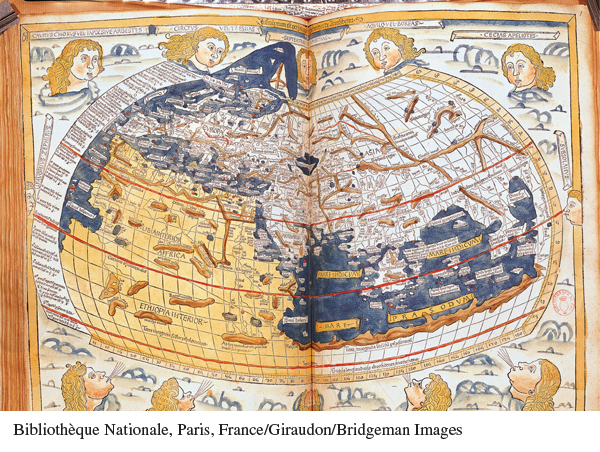
Great strides in cartography and navigational aids were also made during this period. Around 1410 Arab scholars reintroduced Europeans to Ptolemy’s Geography. Written in the second century C.E. by a Hellenized Egyptian, the work synthesized the geographical knowledge of the classical world. Ptolemy’s work provided significant improvements over medieval cartography, clearly depicting the world as round and introducing the idea of latitude and longitude to plot position accurately. It also contained crucial errors. Unaware of the Americas, Ptolemy showed the world as much smaller than it is, so that Asia appeared not very distant from Europe to the west. Both the assets and the flaws of Ptolemy’s work shaped the geographical knowledge that explorers like Christopher Columbus brought to their voyages.
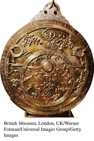
Originating in China, the compass was brought to the West in the late Middle Ages; by using the compass to determine their direction and estimating their speed of travel over a set length of time, mariners could determine the course of a ship’s voyage, a system of navigation known as “dead reckoning.” In the late fifteenth century Portuguese scholars devised a new technique of “celestial reckoning,” which involved using the astrolabe, an instrument invented by the ancient Greeks to determine the position of the stars and other celestial bodies. Commissioned by Portuguese king John II, a group of astronomers in the 1480s showed that mariners could determine their latitude at sea by using a specially designed astrolabe to determine the altitude of the polestar or the sun, and consulting tables of these bodies’ movements. This was a crucial step forward in maritime navigational techniques.
Much of the new technology that Europeans used on their voyages was borrowed from the East. Gunpowder, the compass, and the sternpost rudder were Chinese inventions. The triangular lateen sail, which allowed caravels to tack against the wind, was a product of the Indian Ocean trade world. Advances in navigational techniques and cartography, including the maritime astrolabe, drew on a rich Iberian tradition of Jewish and Arab mathematics and astronomy. Sometimes assistance to Europeans came from humans rather than instruments. The famed explorer Vasco da Gama employed a local Indian pilot to guide his expedition from the East African coast to India. In exploring new territories, European sailors thus called on techniques and knowledge developed over centuries in China, the Muslim world, and the Indian Ocean.