7.6 Deforestation and some forestry management practices deplete soils and increase flooding danger
The Mekong River originates on the Tibetan plateau and flows nearly 3,000 miles through the spectacular tropical forests of southeast Asia—a biodiverse region that supports the livelihoods of some 70 million people. Over the last 40 years, however, these forests have been shrinking dramatically: Cambodia has lost one-fifth of its forests, Laos and Myanmar have lost one-quarter, and Thailand and Vietnam have lost just under half. The people of Southeast Asia will not only be coping with a scarcity of timber as a building material and cooking fuel, but they will also see changes in the functioning of their ecosystems. In a region known for heavy monsoon rains, the loss of forest cover will stimulate increased erosion, landslides, and degradation of soils. Rainwater normally collected and purified in forested basins will be cloudy with sediment, harming the freshwater fish that feed so much of the population.
The situation in the Greater Mekong Basin is part of a larger story of the loss of forests around the world for timber and agriculture. According to the United Nations Food and Agriculture Organization’s Global Forest Resources Assessment, updated in 2015, forests cover approximately 4 billion hectares, or 31% of the world’s land area, and are being lost at a rate of 13 million hectares per year. This rate of deforestation is slightly lower than it was in the 1990s, but forests are still vanishing at an alarming rate. The highest rates of deforestation are occurring in places with the highest levels of biodiversity, including Southeast Asia, South America, and Africa. However, deforestation is also occurring at very high rates in temperate and boreal forests. In Russia, over 400,000 km2 of boreal forest was cleared from the late 1990s to the early 2000s—that’s slightly more than the entire state of Montana.
Forest Harvest and Clearing
clear-cutting An economically efficient technique whereby an entire area is cleared of its trees.
The practice of forestry involves the cutting and removal of trees and other plant material for timber, fuelwood, and paper pulp. In temperate regions, foresters typically employ clear-cutting, an economically efficient technique whereby an entire area is cleared of its trees. Because clear-cutting is often done with heavy equipment in steep terrain, it produces high levels of soil disturbance, which leaves the bare mountainside exposed to erosion (Figure 7.17). As erosion removes topsoil from these forested landscapes, their potential to produce future crops of timber is reduced.
LOGGING ACTIVITIES COMMONLY PRODUCE SIGNIFICANT SOIL DISTURBANCE
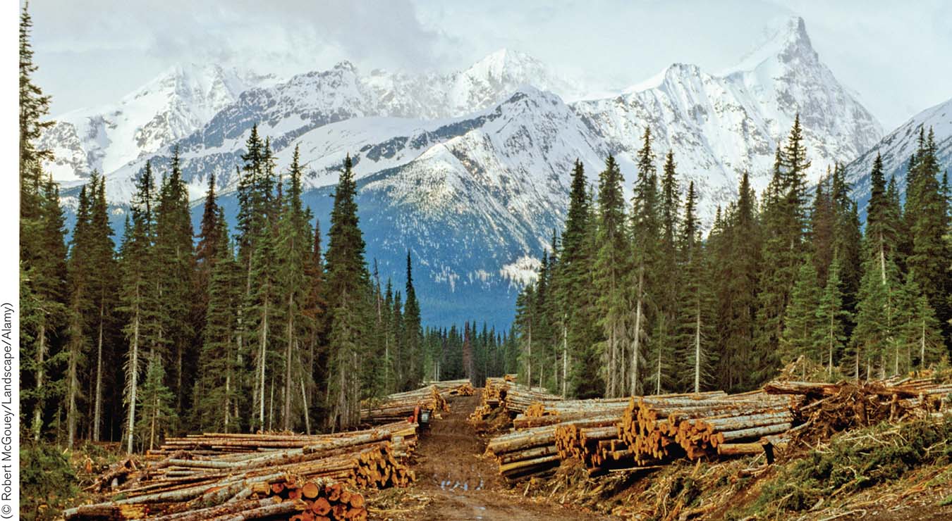
FIGURE 7.17 Exposure of bare soil and disturbance of topsoil during logging, particularly due to road building and log skidding, create conditions conducive to increased soil erosion.
(© Robert McGouey/Landscape/Alamy)
Many studies have been done to quantify the effects of logging on soil loss, which is often measured as the amount of soil transported by streams flowing out of forested stream basins, generally standardized as “sediment yield” per square kilometer. One such study in the mountains of southern British Columbia, Canada, compared sediment yields in side-by-side stream basins. One of the two basins, Redfish, had the trees removed from approximately 10% of its area, whereas the other, Laird, was unlogged. In addition, 19 kilometers of roads had been built in the Redfish Basin during logging operations, whereas no roads had been built in the Laird Basin. Despite the small area logged, logging in the Redfish Basin was associated with a 50% increase in soil losses from erosion (Figure 7.18).
STUDIES SHOW THAT LOGGING INCREASES RATES OF SOIL EROSION
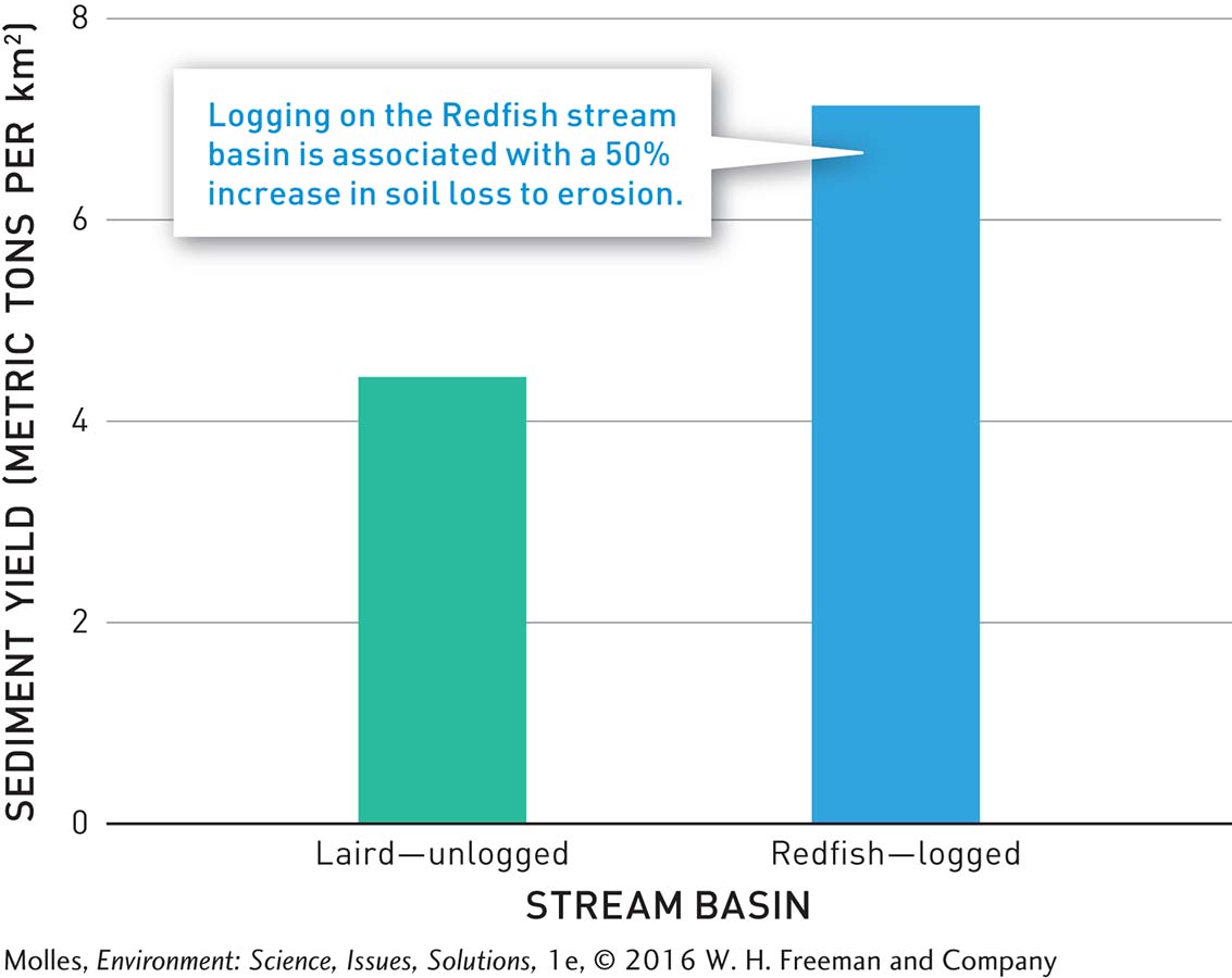
FIGURE 7.18 This graph compares a nine-year average of soil losses, as measured by sediments transported in the associated streams, in two stream basins. One of the basins, Redfish, had been logged over 10% of its area and included 19 kilometers of logging roads, whereas the other basin, Laird, was unlogged and had no roads. (Data from Jordan, 2006)
Page 203
slash-and-burn A common technique used in tropical countries to rapidly convert forestlands into temporary farms.
Finally, slash-and-burn is a common technique used in tropical countries to rapidly convert forestlands into temporary farms. Rather than harvesting the timber, trees are burned, thereby releasing some of their nutrients into the poor tropical soils, which remain fertile for several years. Slash-and-burn has been an effective form of agriculture for regions with low population densities. However, it is not an effective or sustainable practice for large populations at an industrial scale because widespread slash-and-burn practice would result in massive erosion and loss of soil fertility.
Fire Suppression
Forest ecosystems do not have to be logged to be harmed. In the western United States, pine stands once featured an open understory of widely spaced trees (Figure 7.19a), which was a consequence of frequent, low-intensity fires, caused by lightning or Native Americans, who traditionally cleared vegetation to improve habitat for game animals. To protect valuable timber resources, the U.S. Forest Service began a policy of fire suppression in 1910, and tree densities have since increased to hundreds or thousands per hectare (Figure 7.19b).
FIRE PROTECTION IN FORESTS OF THE WESTERN UNITED STATES HAS INCREASED THE DENSITY OF TREE POPULATIONS
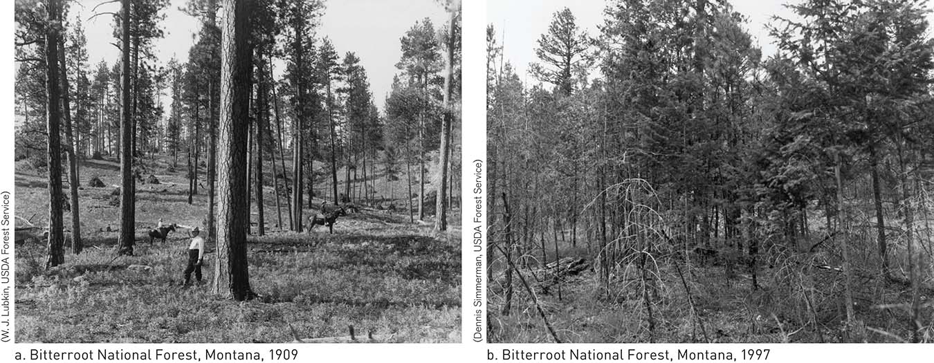
FIGURE 7.19 Historically, ponderosa pines in Arizona and elsewhere in the American West grew at low densities, producing a parklike landscape. After decades of fire protection, however, the densities of ponderosa pines in these landscapes increased to unsustainable levels.
(W. J. Lubkin, USDA Forest Service) (Dennis Simmerman, USDA Forest Service)

Where livestock have been introduced and fires suppressed, North American grasslands have gradually changed to shrublands or woodlands. Why?
When fires occur in these forests, which are now much denser with woody growth, they generally burn larger areas with greater intensity. The catastrophic 2011 Wallow Fire in eastern Arizona that burned nearly 2,100 km2 (817 mi2) of forest, the most extensive in the history of the state, is an example of such a fire (Figure 7.20a). These high-intensity fires result in massive losses of soil carbon and nutrients from the fire itself as well as from subsequent erosion (Figure 7.20b). Ironically, fire suppression has made the forests of western North America more vulnerable to fires and more susceptible to soil and nutrient loss.
OFTEN THE LONG-TERM CONSEQUENCE OF FIRE PROTECTION HAS BEEN, IRONICALLY, CATASTROPHIC FIRE
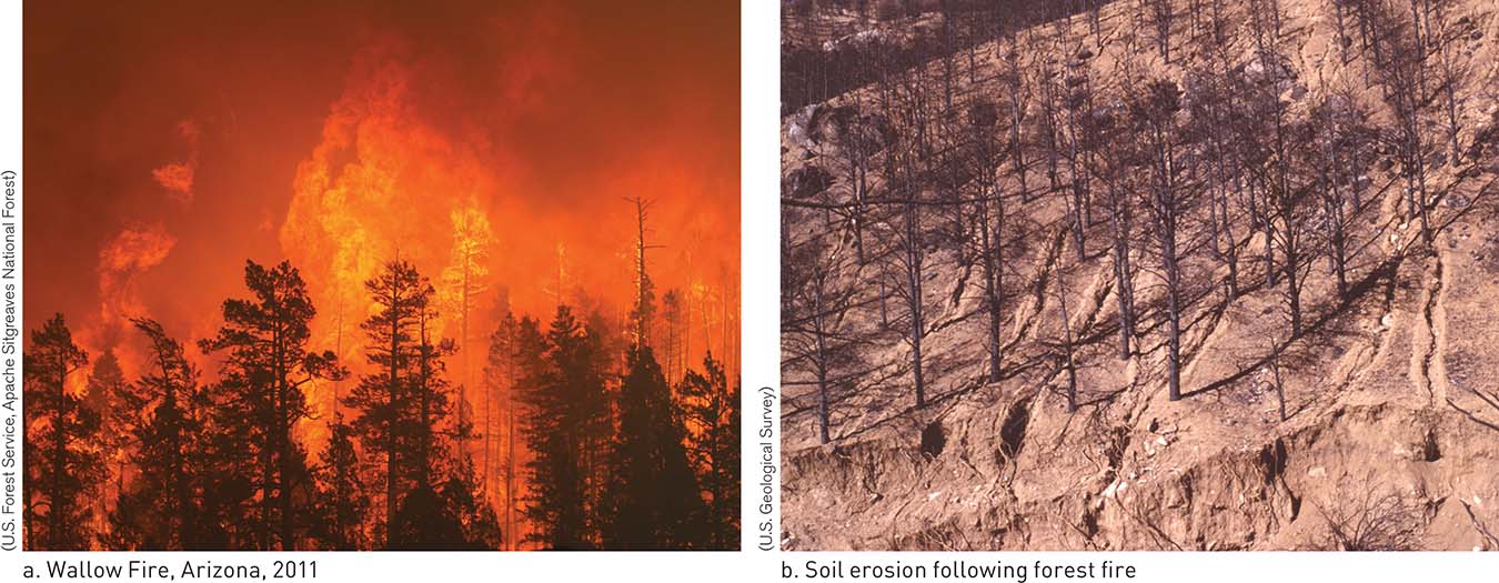
FIGURE 7.20 The Wallow Fire of 2011 burned with such intensity that it consumed more than 200,000 hectares (500,000 acres) of forest in Arizona before firefighters could contain it. One consequence of intense forest fires, such as the Wallow Fire, is massive soil loss to erosion.
(U.S. Forest Service, Apache Sitgreaves National Forest) (U.S. Geological Survey)
Page 204
Think About It
What are the consequences of the loss of forest in the Mekong River Basin?
What are some of the environmental damages resulting from clear-cutting of forests?
How have fire suppression efforts altered forests in the western United States?