Preface
In this text, we portray the rich diversity of human life across the world and humanize geographic issues by representing the daily lives of women, men, and children in the various regions of the globe. Our goal is to make global patterns of trade and consumption meaningful for students by showing how these patterns affect not only world regions but also ordinary people at the local level. In striving to reach this goal, we have made this sixth edition of World Regional Geography as current, instructive, and visually appealing as possible.
Continuing in The Sixth Edition
Thematic Concepts
Teaching world regional geography is never easy. Many instructors have found that focusing their courses on a few key ideas makes their teaching more effective and helps students retain information. With that goal in mind, we have identified nine thematic concepts that provide a few basic hooks on which students can hang their growing knowledge of the world and each of its regions. These thematic concepts are listed here in the order in which they are first covered in Chapter 1:
- Population: What are the major forces driving population growth or decline in a region? How have changes in gender roles influenced population growth? How are changes in life expectancy, family size, and the age of the population influencing population change?
- Gender: How do the lives and livelihoods of men and women differ, and how do gender roles influence societies in a region? To what extent do men and women differ in their contributions to family and community well-being? From what do persistent disparities in income, education, and rights between genders arise?
- Development: How do shifts in economic, social, and other dimensions of development affect human well-being? What paths have been charted by the so-called developed world, and how are they relevant, or irrelevant, to the rest of the world? What new “homegrown” solutions are emerging from the so-called less-developed countries?
- Food: How do food production systems impact environments and societies in a region? How has the use of new agricultural technologies impacted farmers? How have changes in food production created pressure to urbanize?
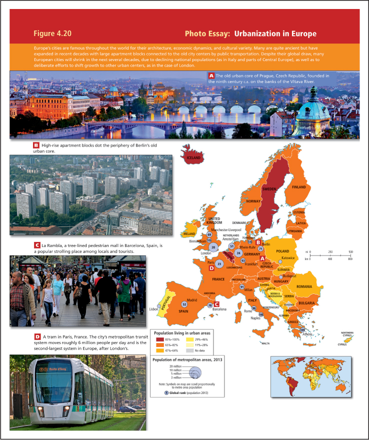
- Urbanization: Which forces are driving urbanization in a particular region? How have cities responded to growth? How is the region affected by the changes that accompany urbanization—for example, changes in employment, education, and access to health care?
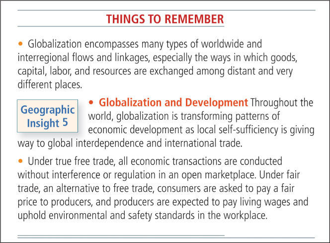
- Globalization: How has a particular region been impacted by globalization, historically and currently? How are lives changing as flows of people, ideas, products, and resources become more global?
- Power and Politics: What are the main differences in the ways that power is wielded in societies? Which types of governance tend to arise from centralized power? Which tend to arise when individuals in a society have more say in the development of policies and the ways that governments are run?
- Water: How do issues of water scarcity, water pollution, and water management affect people and environments in a particular region? How might global climate change and changes in food production systems affect water resources?
- Climate Change: What are the indications that climate change is underway? How are places, people, and ecosystems in a particular region vulnerable to the shifts that climate change may bring? How are people and governments in the region responding to the threats posed by global warming? Which human activities contribute significant amounts of greenhouse gases?
Photos
Photos are a rich source of geographic information, and at the beginning of each regional chapter, a series of photos surrounding the regional map introduce the reader to landscapes within the region. Photo Essay figures illustrate particular thematic concepts. For example, a photo essay about urbanization might include a map of urban patterns in that region as well as photos that illustrate various aspects of current urban life in that part of the world. Photos also are central to new features on Local Lives and Visual Histories.
New to The Sixth Edition
The Thematic Concepts form the basis for this edition’s new Geographic Insights. For each chapter, alone and in combination, the thematic concepts form the basis of five to six learning objectives that we call Geographic Insights. These insights are stated at the beginning of each chapter and discussed at the relevant point in the text. They also are reviewed in “Things to Remember” sections found throughout the chapter, as well as in new questions posed in the “Geographic Insights Review and Self-Test” section at the end of each chapter.
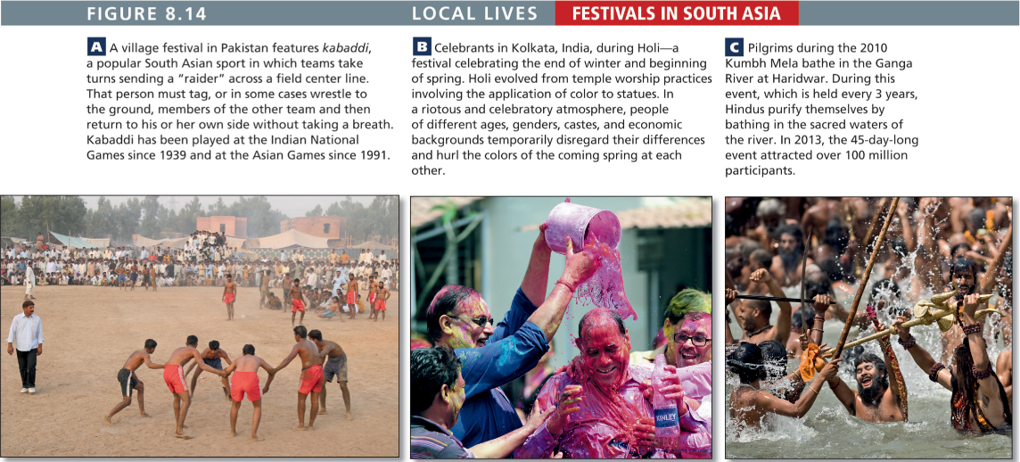
In this edition there are Visual Histories (with timelines) for each region, which use images to illustrate key points in the region’s history. On the Bright Side commentaries explore some of the more hopeful patterns and opportunities emerging within each region. Three new Local Lives photo features in each region chapter add further human interest by showing regional customs related to foodways, people and animals, and festivals.
To help instructors make use of all these new photo features in their teaching, the text offers Thinking Geographically questions with many photo essays and photo figures. The answers can be found on this book’s Web site, where they form the basis of computer-graded exercises that can be assigned and automatically graded and entered into each instructor’s grade book.
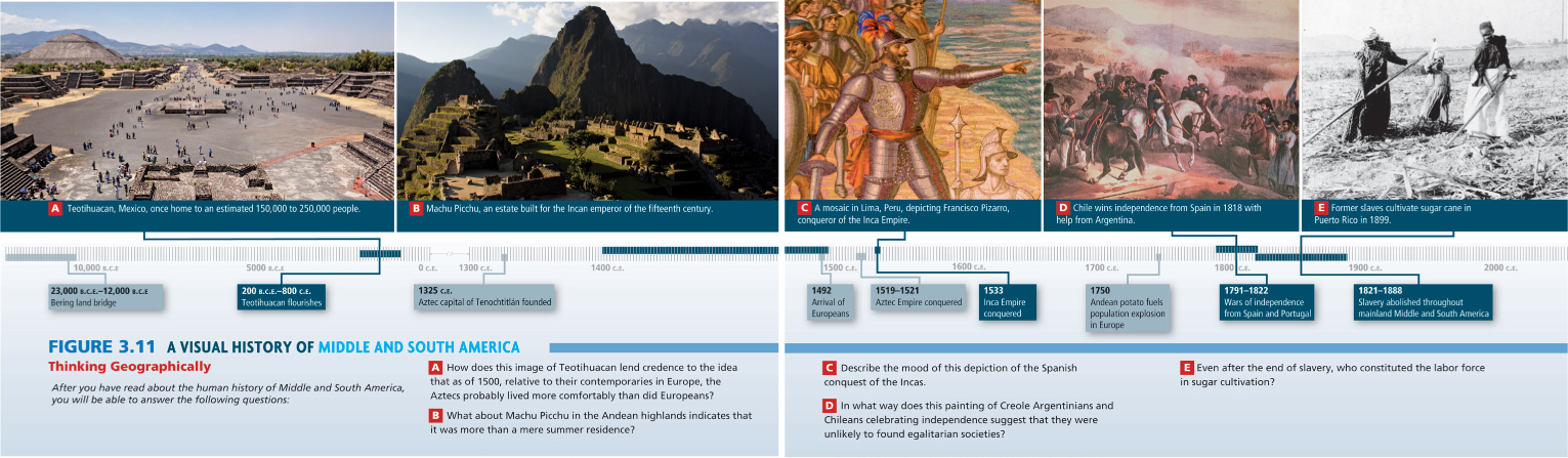
3.11a Courtesy Bjorn Holland/The Image Bank/Getty Images, 3.11b Courtesy lluís Vinagre/Flickr/Getty Images, 3.11c Courtesy Danita Delimont/Gallo Images/Getty Images, 3.11d Courtesy Spanish School/The Bridgeman Art Library/Getty Images, 3.11e Courtesy M.H. Zahner/Library of Congress
Restructured Chapters
Each chapter includes a variety of features to support the teaching and learning of world regional geography.
Things to Remember At the close of every main section, a few concise statements review the important points in the section. The statements emphasize some key themes while encouraging students to think through the ways in which the material illustrates these points. They also review the Geographic Insights that begin each chapter.
Geographic Insights Review and Self-Test At the end of each chapter, a series of questions, many tied to the chapter’s Geographic Insights, encourage students to more broadly analyze the chapter content. These questions could be used for assignments, group projects, or class discussion.
Marginal Glossary of Key Terms Terms important to the chapter content are boldfaced on first usage and defined on the page on which they appear. The terms are listed at the end of the chapter, with the page numbers where they are defined. The key terms are also listed alphabetically and defined in the glossary at the end of the book.
Consistent Base Maps This edition focuses on improving further what has often been cited as a principal strength of this text: high-quality, relevant, and consistent maps. To help students make conceptual connections and to compare regions, every chapter contains the following:
- Regional map with landscape photos at the beginning of each chapter
- Political map
- Climate map with photos of different climate zones
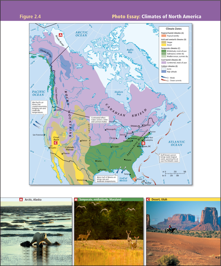 FIGURE 2.4 Photo Essay: Climates of North America 2.4a Courtesy Lowell Georgia/National Geographic/Getty Images, 2.4b Courtesy Linda Davidson/The Washington Post via Getty Images, 2.4c Courtesy DEA/F. Barbagallo/De Agostini/Getty Images
 - Map of the human impacts on the biosphere, with photo essay
- Map of the region’s vulnerability to climate change, with photo essay
- Urbanization map, with photo essay
- Map of regional power and politics, with photo essay
- Map of population density
- Maps of geographic patterns of human well-being
- Maps of subregions
New Photos
An ongoing aim of this text has been to awaken students to the circumstances of people around the world, and photos are a powerful way to accomplish this objective. This edition continues our tradition of promoting careful attention to photos by including in Chapter 1 a short lesson on photo interpretation. Students are encouraged to use these skills as they look at every photo in the text, and instructors are encouraged to use the photos as lecture themes and to help generate analytical class discussions.
Each photo was chosen to complement a Thematic Concept or situation described in the text. All photos are numbered and referenced in the text, making it easier for students to integrate the text with the visuals as they read. Moreover, the photos—like all of the book’s graphics, including the maps—have been given significant space and prominence in the page layout. The result is a visually engaging, dynamic, and instructive text. All photo credits are at the end of the book, listed according to figure numbers.
Videos
More than 300 videos clips (an average of 27 per chapter) are available with the sixth edition. Most videos are 2 to 6 minutes long and cover key issues discussed in the text. They can help instructors gain further expertise or can be used to generate class discussion. Each video is keyed to the text with an icon at the point in the discussion where it is most relevant. These videos, along with a related multiple-choice quiz, can be accessed at www.whfreeman.com/geographyvideos. Questions can be automatically graded and entered into a grade book. To access the videos, students need a password that can be bundled free with this textbook.
Up-to-Date Content
Because the world is constantly changing, it is essential that a world regional geography text be as current as possible. To that end, the sixth edition discusses the Arab Spring and its aftermath in North Africa and Southwest Asia; the varying effects of the global recession on regions, countries, and individuals; civil unrest in once-stable Thailand; the new influence of Arabic media outlets, such as Al Jazeera, which now affect thinking around the world; and the consequences of global climate change on Pacific Island nations. Some of the major content areas of the book that have been updated include:
- Political revolutions and conflict in North Africa and Southwest Asia (the Middle East)
- Maps reflecting the new country of South Sudan (some data remain based on Sudan as a whole because South Sudan has not yet begun reporting statistics)
- The global economic recession and its effect on migrants, labor outsourcing, and job security in importing and exporting countries
- Domestic and global implications of the U.S. political, economic, and military stances
- The role of terrorism in the realignment of power globally and locally
- Immigration and the ways it is changing countries economically and culturally
- Recent economic crises in the European Union which may bring about significant reorganization that has consequences for the original EU members, new and potential member states, and the global community
- Changing gender roles, particularly in developing countries
- The increasing role and influence of Islam around the world
- Climate change and its environmental, political, and economic implications
The Enduring Vision: Global And Local Perspectives
The Global View
In addition to the new features and enhancements to the text, we retain the hallmark features that have made the first five editions of this text successful for instructors and students. For the sixth edition, we continue to emphasize global trends and the interregional linkages that are changing lives throughout the world, including those trends related to changing gender roles. The following linkages are explored in every chapter, as appropriate:
- The multifaceted economic linkages among world regions. These include (1) the effects of colonialism; (2) trade; (3) the role in the world economy of transnational corporations such as Walmart, Norilsk Nickel, Nike, and Apple; (4) the influence of regional trade organizations such as ASEAN and NAFTA; and (5) the changing roles of the World Bank and the International Monetary Fund as the negative consequences of structural adjustment programs become better understood.
- Migration. Migrants are changing economic and social relationships in virtually every part of the globe. The societies they leave are changed radically by the migrants’ absence, just as the host societies are changed by their presence. The text explores the local and global effects of foreign workers in places such as Japan, Europe, Africa, the Americas, and Southwest Asia, and the increasing number of refugees resulting from conflicts around the world. Also discussed are long-standing migrant groups, including the Overseas Chinese and the Indian diasporas.
- Mass communications and marketing techniques are promoting world popular culture across regions. The text integrates coverage of popular culture and its effects in discussions of topics such as tourism in the Caribbean and Southeast Asia; the wide-ranging impact of innovations originating in modernizing economies, such as Ushahidi in Kenya; and the blending of Western and traditional culture in places such as South Africa, Malawi, Japan, and China.
- Gender issues are covered in every chapter with the aim of covering more completely the lives of ordinary people. Gender is intimately connected to other patterns, including internal and global migration, and these connections and other region-wide gender patterns are illustrated in a variety of maps and photos and in vignettes that illustrate gender roles as played out in the lives of individuals. The lives of children, especially with regard to their roles in families, are also covered, often in concert with the treatment of gender issues.
The Local Level
Our approach pays special attention to the local scale—a town, a village, a household, an individual. Our hope is, first, that stories of individual people and families will make geography interesting and real to students; and second, that seeing the effects of abstract processes and trends on ordinary lives will dramatize the effects of these developments for students. Reviewers have mentioned that students particularly appreciate the personal vignettes, which are often stories of real people (with names disguised). For each region, we examine the following local phenomena:
- Local lives: We use photo essays to focus on particular regional customs and traditions as they relate to foodways, festivals, and the relationship of animals to the people of a region.
- Cultural change: We look closely at changes in the family, gender roles, and social organization in response to urbanization, modernization, and the global economy.
- Impacts on well-being: Ideas of what constitutes “well-being” differ from culture to culture, yet broadly speaking, people everywhere try to provide a healthful life for themselves in a community of their choosing. Their success in doing so is affected by local conditions, global forces, and their own ingenuity.
- Issues of identity: Paradoxically, as the world becomes more tightly knit through global communications and media, ethnic and regional identities often become stronger. The text examines how modern developments such as the Internet and related technologies are used to reinforce particular cultural identities, often bringing educated emigrants back to help with reforms or to facilitate rapid responses in crises.
- Local attitudes toward globalization: People often have ambivalent reactions to global forces. They are repelled by the seeming power of these forces, fearing effects on their own lives and livelihoods and on local traditional cultural values, but they are also attracted by the economic opportunities that may emerge from greater global integration. The text looks at how the people of a region react to cultural and economic globalization.
One Vision, Two Versions: With or Without Subregional Coverage
To better serve the different needs of diverse faculty and curricula, three versions of this textbook are available.
World Regional Geography with Subregions, Sixth Edition
(1-4641-1070-0)
The sixth edition continues to employ a consistent structure for each chapter. Each chapter beyond the first is divided into three parts: The Geographic Setting, Current Geographic Issues, and Subregions.
The subregion coverage provides a descriptive characterization of particular countries and places within the region that expands on coverage in the main part of the chapter. For example, the sub-Saharan Africa chapter considers the West, Central, East, and Southern Africa subregions, providing additional insights into differences in well-being and into social and economic issues across the African continent.
World Regional Geography Without Subregions, Sixth Edition
(1-4641-1069-7)
The briefer version provides essentially the same main text coverage as the version described above, omitting only the subregional sections. This version contains all the types of pedagogy found in the main version.
World Regional Geography Concepts, Third Edition
(1-4292-5366-5)
This more compact version is designed to allow instructors to cover all world regions in a single semester.
For The Instructor: A Wealth of Resources Online at Launchpad For Pulsipher, World Regional Geography
 www.whfreeman.com/pulsipher6e (before August 2014)
www.whfreeman.com/launchpad/pulsipher6ewithsubregions (after August 2014)
www.whfreeman.com/launchpad/pulsipher6ewithoutsubregions (after August 2014)
The authors have taught world regional geography many times and understand the need for quick, accessible aids to instruction. Many of the new features were designed to streamline the job of organizing the content of each class session, with the goal of increasing student involvement through interactive discussions. Ease of instruction and active student involvement were the principal motivations behind the book’s key features—the thematic concepts and geographic insights, the photo essays, the content maps that facilitate region-to-region comparisons, the photo features on local lives and regional customs, the feature commentaries that highlight bright and emerging reasons for optimism, and the wide selection of videos.
All of the following are available on the book’s companion Web site, at www.whfreeman.com/pulsipher6e. Many resources offer free and open access. Premium resources are available on LaunchPad, a complete course management system featuring full gradebook and reporting capacities. For a demo of LaunchPad, please email us at geography@whfreeman.com.
- All text images in PowerPoint and JPEG formats with enlarged labels for better projection quality.
- PowerPoint lecture outlines by Bharath Ganesh, University College London. The main themes of each chapter are outlined and enhanced with images from the book, providing a pedagogically sound foundation on which to build personalized lecture presentations.
- Instructor’s resource manual by Jennifer Rogalsky, State University of New York, Geneseo, and Helen Ruth Aspaas, Virginia Commonwealth University, contains suggested lecture outlines, points to ponder for class discussion, and ideas for exercises and class projects. It is offered as chapter-by-chapter Word files to facilitate editing and printing.
- Test Bank by Rebecca Johns, University of South Florida, expanded from the original test bank created by Jason Dittmer, University College London, and Andy Walter, West Georgia University. The Test Bank is designed to match the pedagogical intent of the text and offers more than 2500 test questions (multiple choice, short answer, matching, true/false, and essay) in a Word format that makes it easy to edit, add, and resequence questions. A computerized test bank (powered by Diploma) with the same content is also available. Please use the following ISBNs to request your computerized test bank on disc: 1-4641-2119-2 (with subregions), 1-4641-2128-1 (without subregions).
- Clicker questions by Rebecca Johns, University of South Florida. Prepared in Word, clicker questions allow instructors to jump-start discussions, illuminate important points, and promote better conceptual understanding during lectures.
- Syllabus posting online
- An integrated gradebook that records students’ performance on online and video quizzes
Course Management
All instructor and student resources are also available via BlackBoard, WebCT, Canvas, Angel, Moodle, Sakai, and Desire2Learn. W. H. Freeman offers a course cartridge that populates your site with content tied directly to the book.
W. H. Freeman World Regional Geography DVD
This DVD, available free to adopters of the sixth edition, builds on the book’s purpose of putting a face on geography by giving students and instructors access to the fascinating personal stories of people from all over the world. The DVD contains 35 projection-quality video clips from 3 to 7 minutes in length, with over 300 videos also available online. An instructor’s video manual is also included on the DVD.
For The Student: World Regional Geography Online at Launchpad For Pulsipher, World Regional Geography
www.whfreeman.com/pulsipher6e (before August 2014)
www.whfreeman.com/launchpad/pulsipher6ewithsubregions (after August 2014)
www.whfreeman.com/launchpad/pulsipher6ewithoutsubregions (after August 2014)
A wealth of resources to support the textbook are available online, including the following free and open assets on the companion Web site:
- Chapter quizzes: These multiple-choice quizzes help students assess their mastery of each chapter.
- Thinking Geographically questions: These multiple-choice questions relate to select photos found throughout the book. The question sets form the basis of computer-graded exercises that can be assigned and automatically graded and entered into the instructor’s online grade book.
- Thinking Critically About Geography: These activities, fully updated for the sixth edition, allow students to explore a set of current issues, such as deforestation, human rights, or free trade, and see how geography helps clarify our understanding of them. Linked Web sites are matched with a series of questions or with brief activities that help students think about the ways in which they themselves are connected to the places and people they read about in the text.
- Map Builder software and Map Builder exercises: The Map Builder program allows students to create layered thematic maps on their own, while Map Builder Exercises offer a specific activity for each chapter in the second edition.
- Map learning exercises: Students can use this interactive feature to identify and locate countries, cities, and the major geographic features of each region.
- Blank outline maps: Printable maps of the world, and of each region, are available for note taking, exam review, or both, as well as for preparing assigned exercises.
- Flashcards: Matching exercises teach vocabulary and definitions.
- Audio pronunciation guide: This spoken guide helps students learn to pronounce place names, regional terms, and names of historical figures.
- World recipes and cuisines: From International Home Cooking, the United Nations International School cookbook, this provides students with the opportunity to explore foods from around the world.
LaunchPad offers all the instructor and student resources listed above, as well as premium resources available only on the portal:
- An eBook of World Regional Geography, complete and customizable. Students can quickly search the text and personalize it just as they would the printed version; complete with highlighting, bookmarking, and note-taking features
- A Guide to Using Google Earth for the novice, plus step-by-step Google Earth exercises for each chapter
- Selected articles from Focus on Geography magazine (one for each chapter in the textbook) and accompanying quizzes for each article
- Physical geography videos for instructors who want to cover physical geography topics in more detail
- Online news feeds for highly respected magazines such as the Economist
For more information or to schedule a demo of LaunchPad, please contact your W. H. Freeman sales representative.
NEW! Learning Curve
 Learning Curve is an intuitive, fun, and highly effective formative assessment tool that is based on extensive educational research. It is a key asset of LaunchPad. Students can use Learning Curve to test their knowledge in a low-stakes environment that helps them improve their mastery of key concepts and prepare for lectures and exams. This adaptive quizzing engine moves students from basic knowledge through critical thinking and synthesis skills as they master content at each level. For a demo, visit www.learningcurveworks.com.
Rand McNally’s Atlas of World Geography
This atlas, available at a greatly reduced price when bundled with the textbook, contains:
- Fifty-two physical, political, and thematic maps of the world and continents; 49 regional, physical, political, and thematic maps; and dozens of metro-area inset maps
- Geographic facts and comparisons, covering topics such as population, climate, and weather
- A section on common geographic questions, a glossary of terms, and a comprehensive 25-page index