10.2 The Geographic Setting
What Makes Southeast Asia a Region?
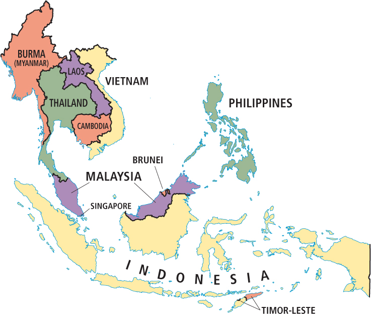
Southeast Asia is physically a manifestation of tectonic forces, which are described in the Physical Patterns section that follows. Aside from physical commonalities, the peninsula and island countries of Southeast Asia today share a deep cultural past, related to but separate from the cultures of southwestern China. They (all except Thailand) also share more recent experiences with European colonialism. During and after World War II, most countries went through severe political turmoil followed by the rapid modernization and industrialization that stretches into the present. The mainland countries are Burma, Thailand, Laos, Cambodia, Vietnam, Malaysia, and Singapore; the island countries are Indonesia, Brunei, Timor-Leste (East Timor), and the Philippines; Malaysia occupies part of the peninsula and parts of the island of Borneo (Figure 10.4).
Terms in This Chapter
Many governments in Southeast Asia choose to dispense with place-names that originated in their colonial past. However, when the governments that make these changes earn broad lack of respect in the international community by violating the human rights of their citizens, their chosen name may not be acknowledged. Such is the case with Burma (Figure 10.4), where a military government seized control in a coup d’état in 1990, shortly after an election, changing the country’s name to Myanmar. As discussed below, the government of Burma is once again in transition; in press reports, both names are used. In this text, we use the country’s traditional name of Burma, not Myanmar.
Another potential point of confusion is Borneo, a large island that is shared by three countries. The part of the island known as Kalimantan is part of Indonesia; while Sarawak and Sabah on the north coast are part of Malaysia; and Brunei is a very small, independent, oil-rich country, also on the north coast.