Physical Patterns
The physical patterns of Southeast Asia have a continuity that is not immediately obvious on a map. A map of the region shows a unified mainland region that is part of the Eurasian continent, and a vast and complex series of islands arranged in chains and groups. These landforms are actually related in tectonic origin. Climate is another source of continuity, with most of the region tropical or subtropical.
Landforms
archipelago a group, often a chain, of islands
The irregular shapes and landforms of the Southeast Asian mainland and archipelago are the result of the same tectonic forces that were unleashed when India split off from the African Plate and gradually collided with Eurasia (see Figure 1.25). As a result of this collision, which is still underway, the mountainous folds of the Plateau of Tibet reach heights of almost 20,000 feet (6100 meters). These folded landforms, which bend out of the high plateau, turn south into Southeast Asia. There, they descend rapidly and then fan out to become the Indochina peninsula. Deep gorges widen out into valleys that stretch toward the sea, each containing hills of 2000 to 3000 feet (600 to 900 meters) and a river or two flowing from the mountains of the Yunnan–Guizhou Plateau of China to the Andaman Sea, the Gulf of Thailand, and the South China Sea (see Figure 10.1A and the figure map). The major rivers of the Indochina peninsula are the Irrawaddy and the Salween in Burma; the Chao Phraya in Thailand; the Mekong, which flows through Laos, Cambodia, and Vietnam; and the Black and Red rivers of northern Vietnam. Several of these rivers have major delta formations—especially the Irrawaddy, Chao Phraya, and the Mekong—that are intensively cultivated and settled (see Figure 10.1B).
The curve formed by Sumatra, Java, the Lesser Sunda Islands (from Bali to Timor), and New Guinea conforms approximately to the shape of the Eurasian Plate’s leading southern edge (see Figure 1.25). Where the Indian-Australian Plate plunges beneath the Eurasian Plate along this curve, hundreds of earthquakes and volcanoes occur, especially on the islands of Sumatra and Java (see Figure 10.1D, E). There are also volcanoes and earthquakes in the Philippines, where the Philippine Plate pushes against the eastern edge of the Eurasian Plate and is in turn pushed by the Pacific Plate. The volcanoes of Southeast Asia are considered part of the Pacific Ring of Fire (see Figure 1.26; see also Figure 10.1C, D).
Volcanic eruptions and the mudflows and landslides that follow eruptions complicate and endanger the lives of many Southeast Asians. Earthquakes are especially problematic because of the tsunamis they can set off (see Figure 10.1E). The tsunami of December 2004, triggered by a giant earthquake (9.1 in magnitude) just north of Sumatra, swept east and west across the Indian Ocean, taking the lives of 230,000 people (170,000 in Aceh Province, Sumatra) and injuring many more. It was one of the deadliest natural disasters in recorded history. There has been a series of strong earthquakes since, with several along coastal Sumatra in August and September of 2009, April and May of 2010, and April of 2012; but they did not generate notable tsunamis. Over the long run, the volcanic material creates new land and provides minerals that enrich the soil for farming.
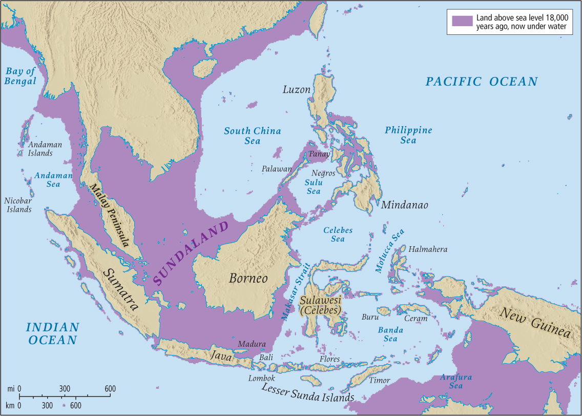
The now-submerged shelf of the Eurasian continent, known as Sundaland (Figure 10.5) extends under the Southeast Asian peninsulas and islands. It was above sea level during the recurring ice ages of the Pleistocene epoch, when much of the world’s water was frozen in glaciers. The exposed shelf allowed ancient people and Asian land animals (such as elephants, tigers, rhinoceroses, and orangutans; Figure 10.6) to travel south to what, when sea levels rose, became the islands of Southeast Asia.
Climate and Vegetation
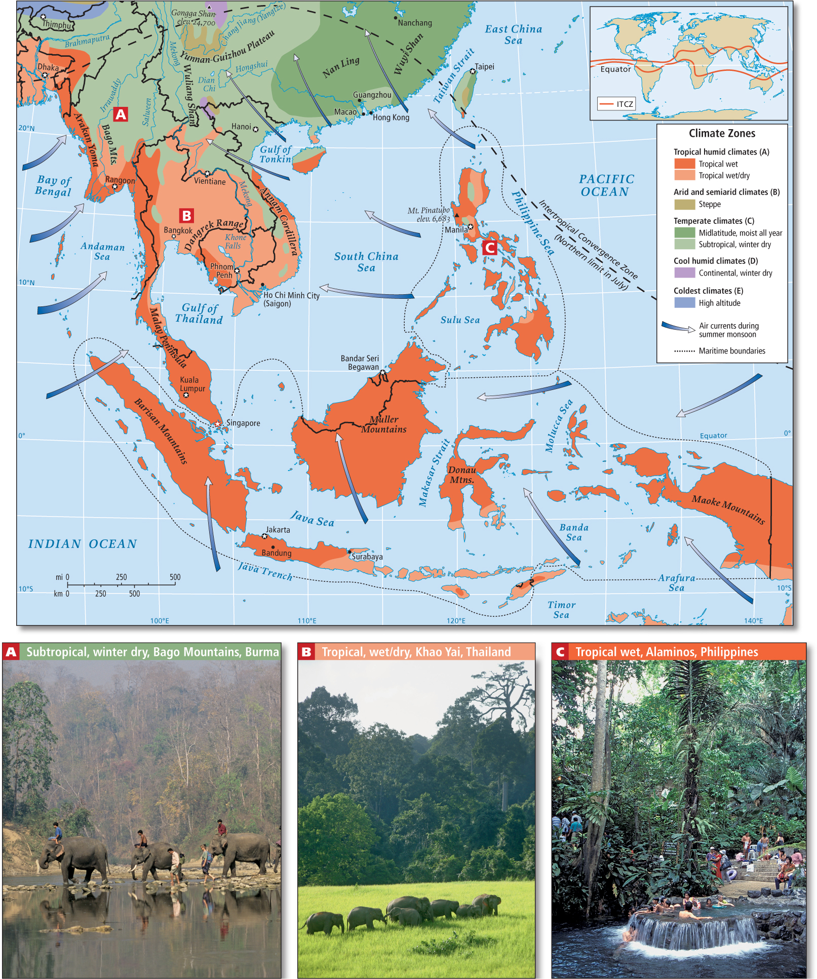
The largely tropical climate of Southeast Asia is distinguished by continuous warm temperatures in the lowlands—consistently above 65°F (18°C)—and heavy rain (Figure 10.7). The rainfall is the result of two major processes: the monsoons (seasonally shifting winds) and the movement of the intertropical convergence zone (ITCZ), an area centered roughly around the equator where surface winds converge from the northern and southern hemispheres and rise upward, resulting in rainfall. The wet summer season extends from May to October, when the warming of the Eurasian landmass sucks in moist air from the surrounding seas and pulls the ITCZ northward (see the Figure 10.7 map). Between November and April, there is a long dry season on the mainland, when the seasonal cooling of Eurasia causes dry, cool air from the interior of the continent to flow out toward the sea, pushing the ITCZ southward (see Figure 11.5). On the many islands, however, the winter can also be wet because the air that flows from the continent warms and picks up moisture as it passes south and east over the seas. The air releases its moisture as rain after ascending high enough over elevated landforms to cool. With rains coming from both the monsoon and the ITCZ, the island part of Southeast Asia is one of the wettest areas of the world.
Irregularly every 2 to 7 years, the normal patterns of rainfall are interrupted, especially in the islands, by the El Niño phenomenon (see Figure 11.6). In an El Niño event, the usual patterns of air and water circulation in the Pacific are reversed. Ocean temperatures are cooler than usual in the western Pacific near Southeast Asia. Instead of warm, wet air rising and condensing as rainfall, cool, dry air sits on the ocean surface. The result is severe drought, often with catastrophic results for farmers and for tinder-dry forests that regularly catch fire. The cool El Niño air can trap smoke and other pollutants at Earth’s surface, creating unusually toxic smog and such low visibility that planes have sometimes crashed.
detritus dead organic material (such as plants and insects) that collects on the ground
THINGS TO REMEMBER
 The irregular shapes and landforms of the Southeast Asian mainland and archipelago are the result of the same tectonic forces that were unleashed when India split off from the African Plate and crashed into Eurasia.
- Continuous warm temperatures in the lowlands and heavy rain distinguish the tropical climate of Southeast Asia, except during those irregular years of the El Niño phenomenon.