1.7 Physical Geography Perspectives
As discussed early in this chapter, physical geography is concerned with the processes that shape the Earth’s landforms, climate, and vegetation. In this sense, physical geographers are similar to scientists from other disciplines who focus on these phenomena, though as geographers they often look at problems and depict the results of their analysis spatially. In this book, physical geography provides a backdrop for the many aspects of human geography we discuss. Physical geography is a fascinating, large, and growing field of study worth exploring in greater detail. What follows are just the basics of landforms and climate.
Landforms: The Sculpting of the Earth
landforms physical features of the Earth’s surface, such as mountain ranges, river valleys, basins, and cliffs
Plate Tectonics
Two key ideas related to internal processes in physical geography are the Pangaea hypothesis and plate tectonics. The geophysicist Alfred Wegener first suggested the Pangaea hypothesis in 1912. This hypothesis proposes that all the continents were once joined in a single vast continent called Pangaea (meaning “all lands”), which then fragmented over time into the continents we know today (see Figure 1.25). As one piece of evidence for his theory, Wegener pointed to the neat fit between the west coast of Africa and the east coast of South America.
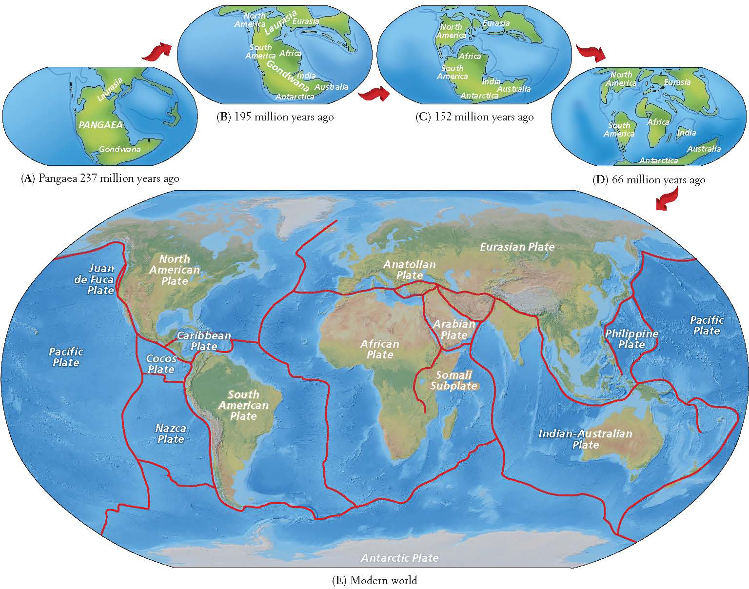
For decades, most scientists rejected Wegener’s hypothesis. We now know, however, that the Earth’s continents have been assembled into supercontinents a number of times, only to break apart again. All of this activity is made possible by plate tectonics, a process of continental motion discovered in the 1960s, long after Wegener’s time.
plate tectonics the scientific theory that the Earth’s surface is composed of large plates that float on top of an underlying layer of molten rock; the movement and interaction of the plates create many of the large features of the Earth’s surface, particularly mountains
Plate movements influence the shapes of major landforms, such as continental shorelines and mountain ranges. Huge mountains have piled up on the leading edges of the continents as the plates carrying them collide with other plates, folding and warping in the process. Plate tectonics accounts for the long, linear mountain ranges that extend from Alaska to Chile in the Western Hemisphere and from Southeast Asia to the European Alps in the Eastern Hemisphere. The highest mountain range in the world, the Himalayas of South Asia, was created when what is now India, situated at the northern end of the Indian-Australian Plate, ground into Eurasia. The only continent that lacks these long, linear mountain ranges is Africa. Often called the “plateau continent,” Africa is believed to have been at the center of Pangaea and to have moved relatively little since the breakup. However, as Figure 1.25 shows, parts of eastern Africa—the Somali Subplate and the Arabian Plate—continue to separate from the continent (the African Plate).
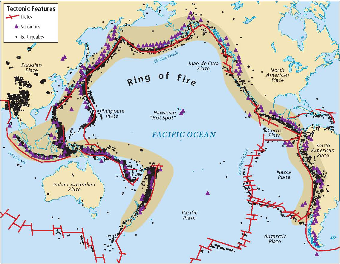
Ring of Fire the tectonic plate junctures around the edges of the Pacific Ocean; characterized by volcanoes and earthquakes
Landscape Processes
weathering the physical or chemical decomposition of rocks by sun, rain, snow, ice, and the effects of life-forms
erosion the process by which fragmented rock and soil are moved over a distance, primarily by wind and water
floodplain the flat land around a river where sediment is deposited during flooding
delta the triangular-shaped plain of sediment that forms where a river meets the sea
Human activity often contributes to external landscape processes. By altering the vegetative cover, agriculture and forestry expose the Earth’s surface to sunlight, wind, and rain. These agents in turn increase weathering and erosion. Flooding becomes more common because the removal of vegetation limits the ability of the Earth’s surface to absorb rainwater. As erosion increases, rivers may fill with silt, and deltas may extend into the oceans.
Climate
weather the short-term and spatially limited expression of climate that can change in a matter of minutes
climate the long-term balance of temperature and precipitation that characteristically prevails in a particular region
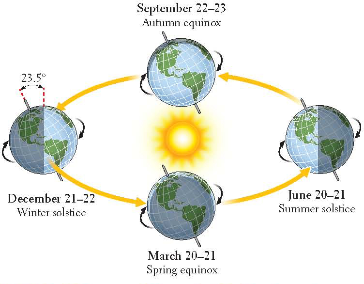
Solar energy is the engine of climate. The Earth’s atmosphere, oceans, and land surfaces absorb huge amounts of solar energy, and the differences in the amounts they absorb account for part of the variations in climate we observe. The most intense direct solar energy strikes the Earth more or less head-on in a broad band stretching about 30° north and south of the equator. The fact that Earth’s axis sits at a 23° angle as it orbits the sun—an angle that does not change—means that where the band of greatest solar intensity strikes the Earth varies in regular sequence over the course of a year, creating seasons. Just how this yearly seasonal pattern works is illustrated by Figure 1.27. The highest average temperatures on the Earth’s surface occur within this band of greatest solar intensity. Moving away from the equator, solar energy strikes the Earth’s surface less directly—at more of an obtuse (wide) angle. This wide angle reduces its heating effect of the sun’s rays and results in lower average annual temperatures.
Temperature and Air Pressure
The wind and weather patterns we experience daily are largely a result of variations in solar energy absorption that create complex patterns of air temperature and air pressure. To understand air pressure, think of air as existing in a particular unit of space—for example, a column of air above a square foot of the Earth’s surface. Air pressure is the amount of force (due to the pull of gravity) exerted by that column on that square foot of surface. Air pressure and temperature are related: The gas molecules in warm air are relatively far apart and are associated with low air pressure. In cool air, the gas molecules are relatively close together (dense) and are associated with high air pressure.
As the sun warms a unit of cool air, the molecules move farther apart. The air becomes less dense and exerts less pressure. Air tends to move from areas of higher pressure to areas of lower pressure, creating wind. If you have been to the beach on a hot day, you may have noticed a cool breeze blowing in off the water. This happens because land heats up (and cools down) faster than water, so on a hot day, the air over the land warms, rises, and becomes less dense than the air over the water. This causes the cooler, denser air to flow inland. At night the breeze often reverses direction, blowing from the now cooling land onto the now relatively warmer water.
These air movements have a continuous and important influence on global weather patterns and are closely associated with land and water masses. Because continents heat up and cool off much more rapidly than the oceans that surround them, the wind tends to blow from the ocean to the land during summer and from the land to the ocean during winter. It is almost as if the continents were breathing once a year, inhaling in summer and exhaling in winter.
Precipitation
precipitation dew, rain, sleet, and snow
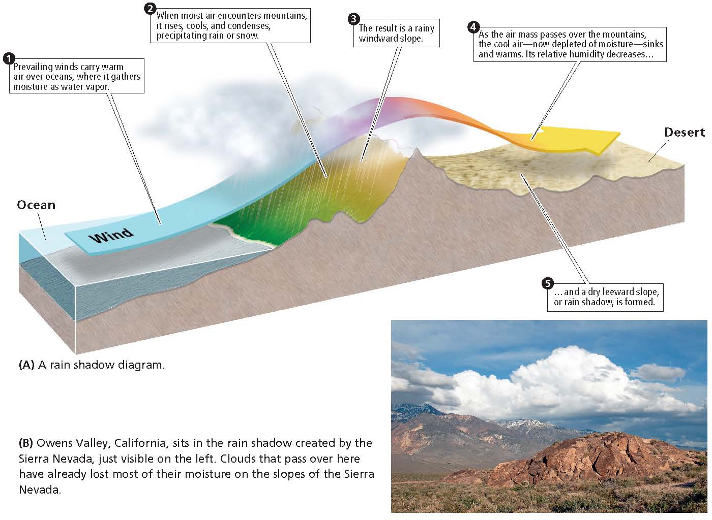
orographic rainfall rainfall produced when a moving moist air mass encounters a mountain range, rises, cools, and releases condensed moisture that falls as rain
A central aspect of Earth’s climate is the “rain belt” that exists in equatorial areas. Near the equator, moisture-laden tropical air is heated by the strong sunlight and rises to the point where it releases its moisture as rain. Neighboring nonequatorial areas also receive some of this moisture when seasonally shifting winds move the rain belt north and south of the equator. The huge downpours of the Asian summer monsoon are an example.
monsoon a wind pattern in which in summer months, warm, wet air coming from the ocean brings copious rainfall, and in winter, cool, dry air moves from the continental interior toward the ocean
Much of the moisture that falls on North America and Eurasia is frontal precipitation caused by the interaction of large air masses of different temperatures and densities. These masses develop when air stays over a particular area long enough to take on the temperature of the land or sea beneath it. Often when we listen to a weather forecast, we hear about warm fronts or cold fronts. A front is the zone where warm and cold air masses come into contact, and it is always named after the air mass whose leading edge is moving into an area. At a front, the warm air tends to rise over the cold air, carrying warm clouds to a higher, cooler altitude. Rain or snow may follow. Much of the rain that falls along the outer edges of a hurricane is the result of frontal precipitation.
Climate Regions
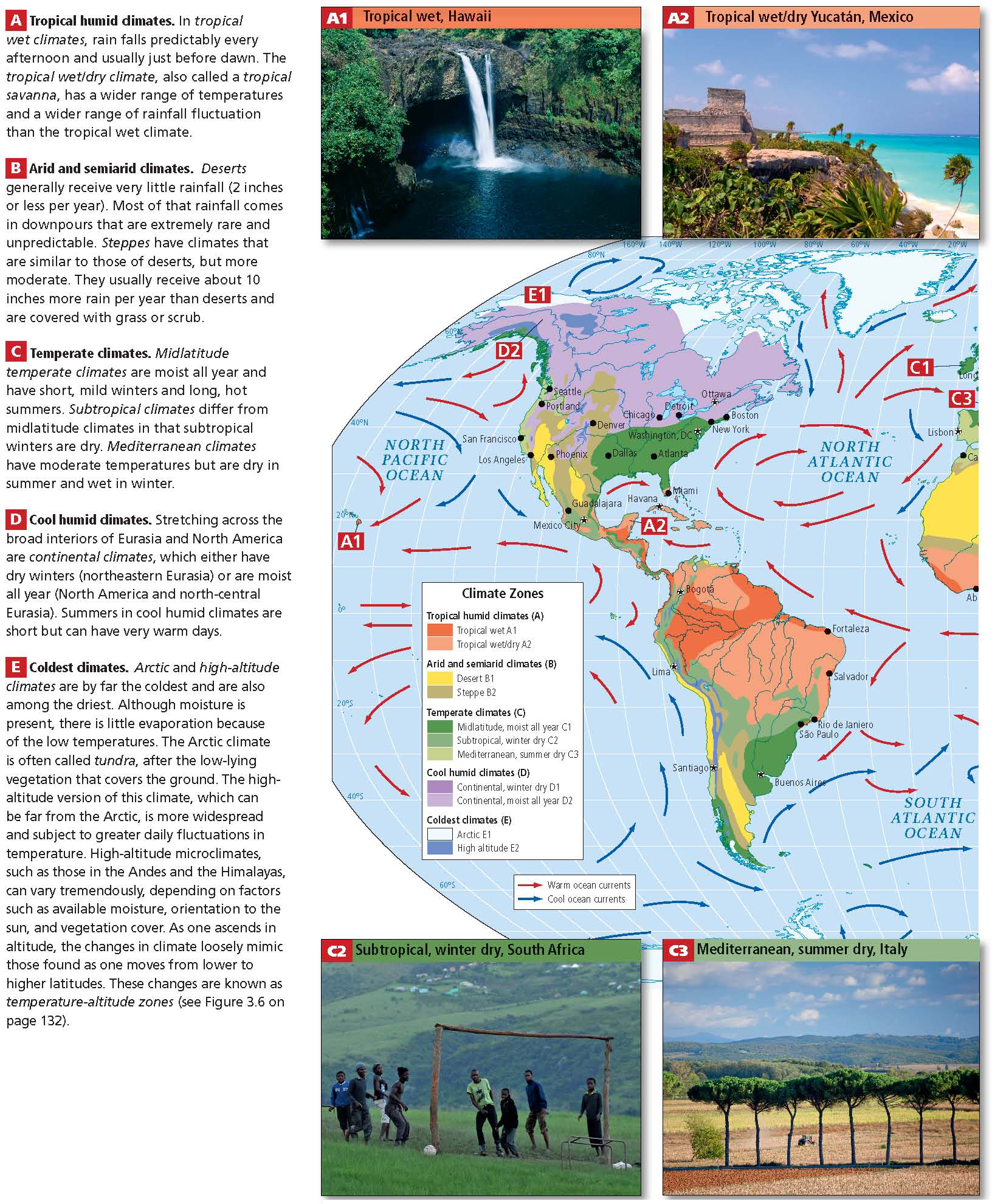
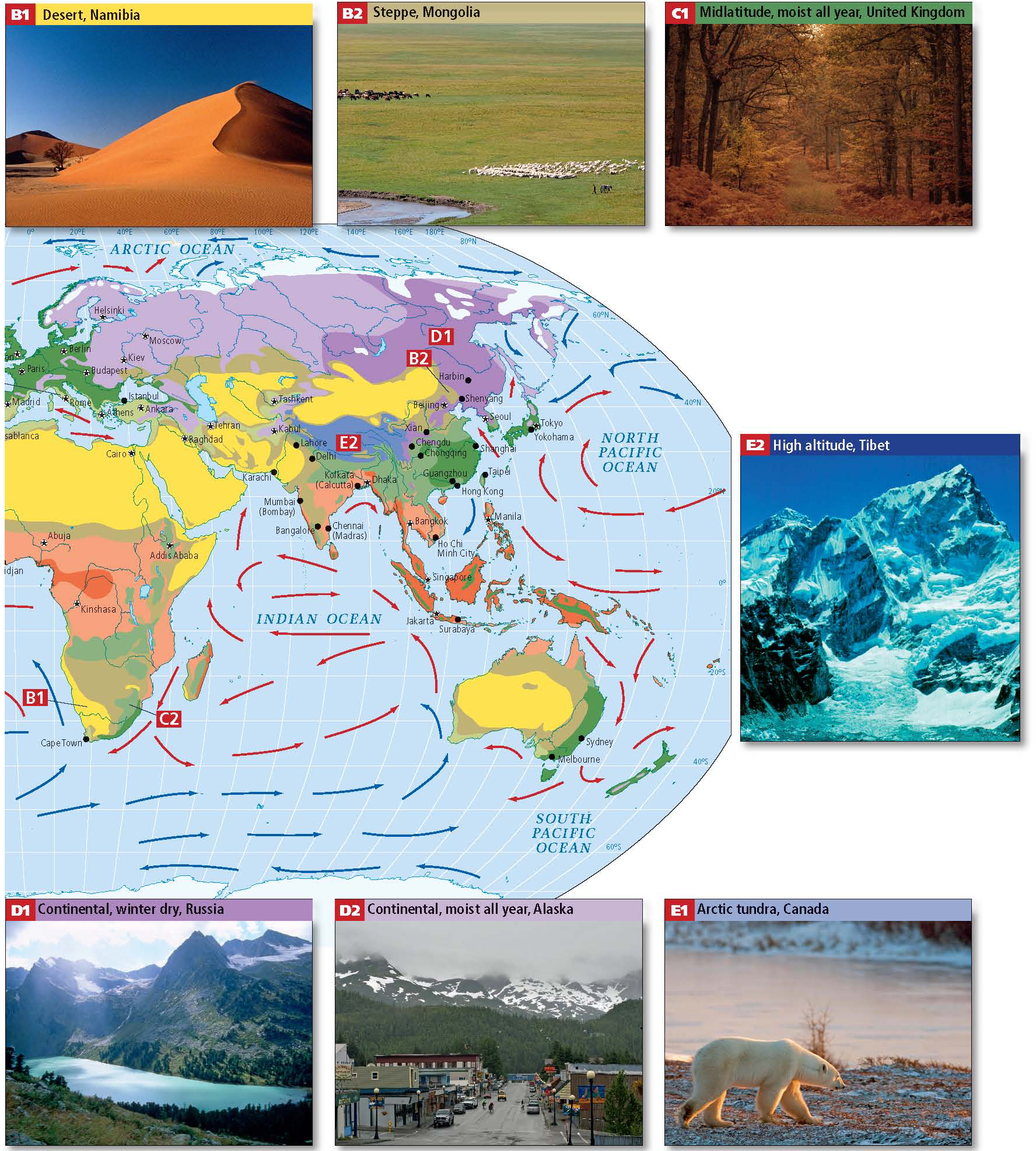
Geographers have several systems for classifying the world’s climates. The systems are based on the patterns of temperature and precipitation just described. This book uses a modification of the widely known Köppen classification system, which divides the world into several types of climate regions, labeled A through E on the climate map in Figure 1.29. As you look at the regions on this map, examine the photos, and read the accompanying climate descriptions, the importance of climate to vegetation becomes evident. Each regional chapter includes a climate map; when reading these maps in any chapter, refer to the written descriptions in Figure 1.29 as necessary. Keep in mind that the sharp boundaries shown on climate maps are in reality much more gradual transitions.
1.29a1 Courtesy UIG/Getty Images, 1.29a2 Courtesy UIG/Getty Images, 1.29b1 Courtesy Hoberman Collection/UIG/Getty Images, 1.29b2 Courtesy Palani Mohan/Getty Images, 1.29c1 Courtesy RDImages/Epics/Getty Images, 1.29c2 Courtesy Alexander Joe/AFP/Getty Images, 1.29c3 Courtesy Tim Graham/Getty Images, 1.29d1 Courtesy Russian Look/UIG/Getty Images, 1.29d2 Courtesy Nikki Kahn/The Washington Post/Getty Images, 1.29e1 Courtesy Paul J. Richards/AFP/Getty Images, 1.29e2 Courtesy P. Morris/Hulton Archive/Getty Images
THINGS TO REMEMBER
 Physical geography focuses on the processes that shape the Earth’s landforms and its climate, and on how human practices interact with physical patterns.
- Landforms are shaped by internal processes, such as plate tectonics, and external processes, such as weathering.
- Seasons occur because of the fact that as the Earth orbits the sun over the course of a year, its axis is positioned at a consistent angle of 23°.
- Variations in air pressure are caused by heating and cooling and account for phenomena such as wind and precipitation patterns.
- Climate is the long-term balance of temperature and precipitation that keeps weather patterns fairly consistent from year to year. Weather is the short-term and spatially limited expression of climate that can change in minutes.