Physical Patterns
Middle and South America extend south from the midlatitudes of the Northern Hemisphere across the equator through the Southern Hemisphere, nearly to Antarctica (see Figure 3.1). This vast north–south expanse combines with variations in altitude to create the wide range of climates in the region. Tectonic forces have shaped the primary landforms of this huge territory to form an overall pattern of highlands to the west and lowlands to the east.
Landforms
There are a wide variety of landforms in Middle and South America, and this variety contributes to the many different climatic zones in the region. But for ease in learning, landforms are here divided into just two categories: highlands and lowlands.
Highlands
subduction zone a zone where one tectonic plate slides under another
In a process that continues today, the leading edge of the overriding plates crumples to create mountain chains. In addition, molten rock from beneath the Earth’s crust ascends to the surface through fissures in the overriding plate to form volcanoes. Such volcanoes are the backbone of the highlands that run through Middle America and the Andes of South America (see Figure 3.1). Although these volcanic and earthquake-prone high-lands have been a major barrier to transportation, communication, and settlement, people now live close to quiescent volcanoes and in earthquake-prone zones, which can pose deadly hazards (for example, the 2010 earthquakes in Peru and Chile).
The chain of high and low mountainous islands in the eastern Caribbean is also volcanic in origin, created as the Atlantic Plate thrusts under the eastern edge of the Caribbean Plate. It is not unusual for volcanoes to erupt in this active tectonic zone. On the island of Montserrat, for example, people have been living with an active, and sometimes deadly, volcano for more than a decade (see Figure 3.1D). Eruptions have taken the form of violent blasts of superheated rock, ash, and gas (known as pyroclastic flows) that move down the volcano’s slopes with great speed and force. The unusually strong earthquake in Haiti in January 2010 was also the result of plate tectonics.
Lowlands
Vast lowlands extend over most of the land to the east of the western mountains. In Mexico, east of the Sierra Madre, a coastal plain borders the Gulf of Mexico (see Figure 3.1H). Farther south, in Central America, wide aprons of sloping land descend to the Caribbean coast. In South America, a huge wedge of lowlands, widest in the north, stretches from the Andes east to the Atlantic Ocean. These South American lowlands are interrupted in the northeast and the southeast by two modest highland zones: the Guiana Highlands and the Brazilian Highlands (see Figure 3.1G). Elsewhere in the lowlands, grasslands cover huge, flat expanses, including the llanos of Venezuela, Colombia, and Brazil, and the pampas of Argentina (see Figure 3.1I).
biodiversity the variety of life forms to be found in a given area
silt fine soil particles
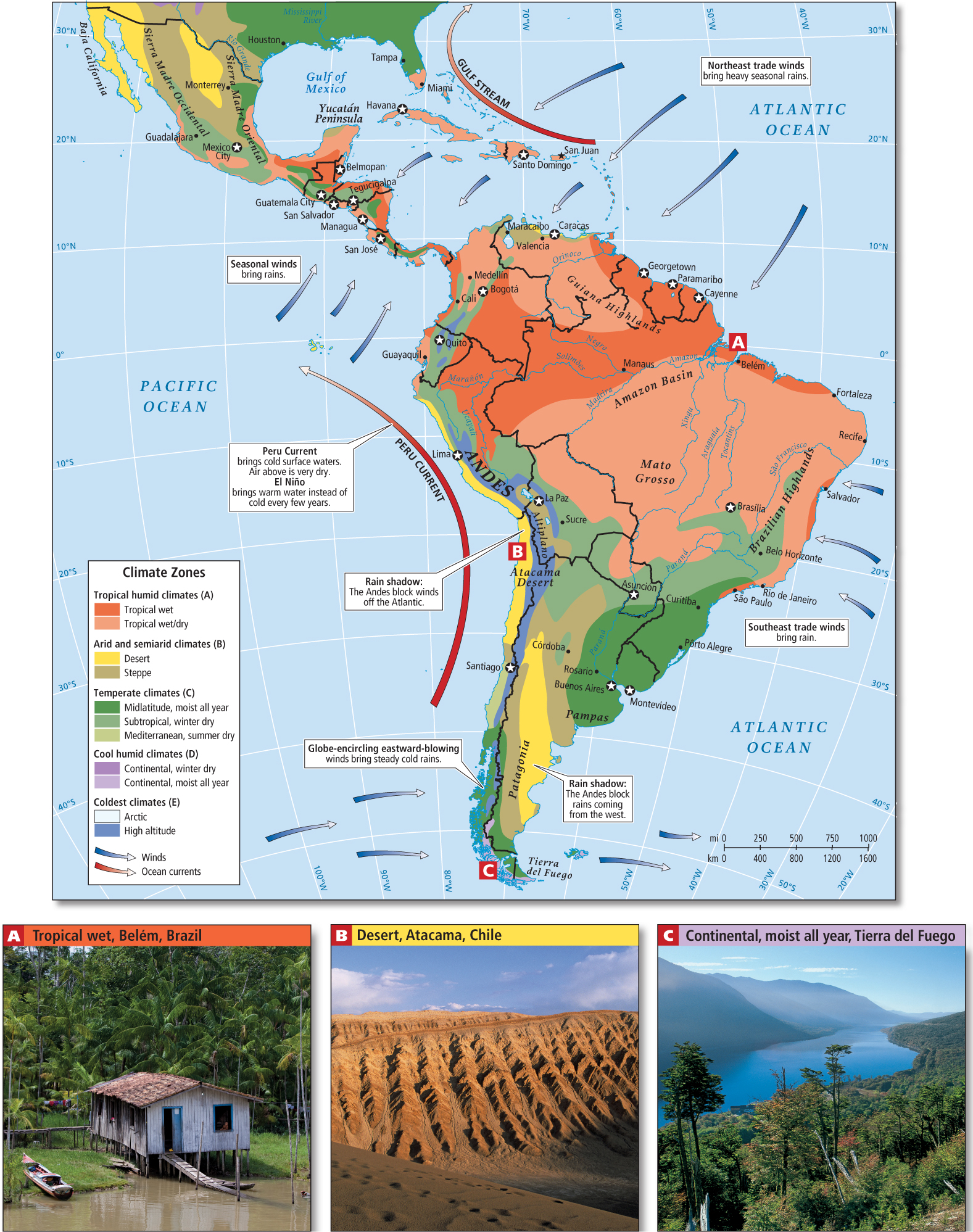
Climate
From the jungles of the Caribbean and the Amazon to the high, glacier-capped peaks of the Andes to the parched moonscape of the Atacama Desert and the frigid fjords of Tierra del Fuego, the climate variety of Middle and South America is enormous (Figure 3.5). Climates are essentially the result of interactions between temperature and moisture. In this region, the wide range of temperatures reflects both the great distance the landmass spans on either side of the equator and the tremendous variations in altitude across the region’s landmass (the highest point in the Americas is Aconcagua in Argentina, at 22,841 feet [6962 meters]). Patterns of precipitation are affected both by the local shape of the land and by global patterns of wind and ocean currents that bring moisture in varying amounts.
Temperature-Altitude Zones
temperature-altitude zones regions of the same latitude that vary in climate according to altitude
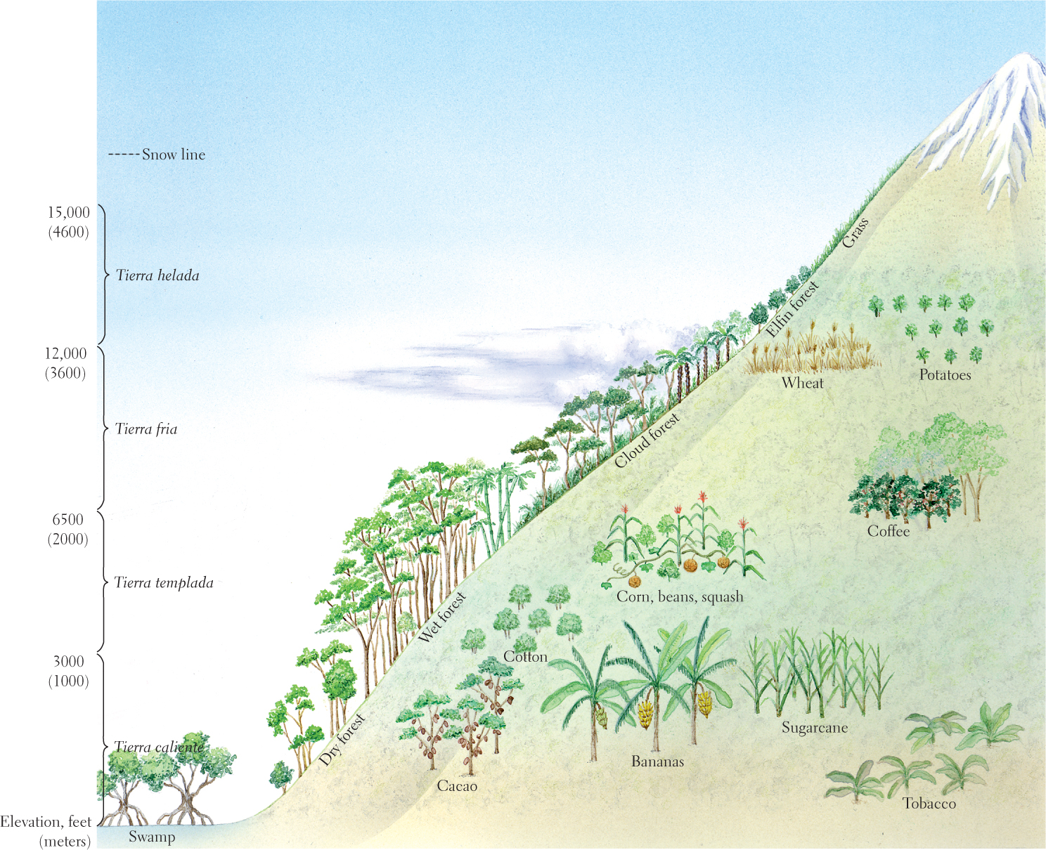
Between 3000 and 6500 feet (1000 to 2000 meters) is the cooler tierra templada (“temperate land”). The year-round, spring-like climate of this zone drew large numbers of indigenous people in the distant past and, more recently, has drawn Europeans. Here, such crops as corn, beans, squash, various green vegetables, wheat, and coffee are grown.
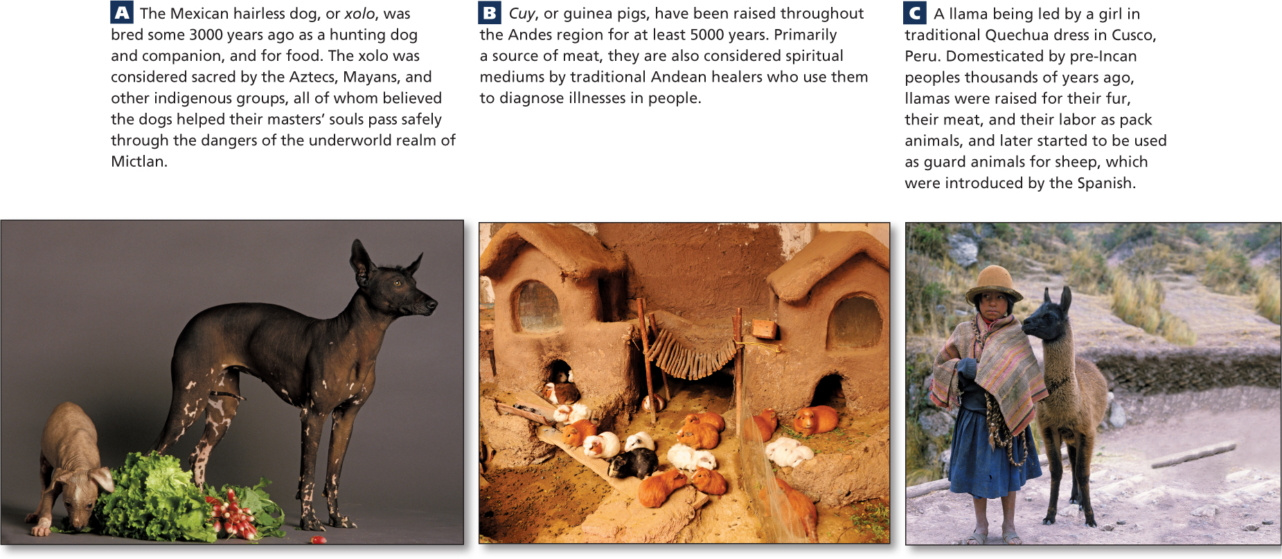
Between 6500 and 12,000 feet (2000 to 3600 meters) is the tierra fria (“cool land”). A variety of crops, such as wheat, fruit trees, potatoes, and cool-weather vegetables—cabbage and broccoli, for example—do very well at this altitude. Many animals—such as dogs, llamas, sheep, and guinea pigs (Figure 3.7)—are raised for pets, food, and fiber. Several modern population centers are in this zone, including Mexico City, Mexico, and Quito, Ecuador.
3.7a Courtesy Raphael Gaillarde/Gamma-Rapho via Getty Images, 3.7b Courtesy Education Images/UIG via Getty Images, 3.7c Courtesy Michele Burgess/Photolibrary/Getty Images
Above 12,000 feet (3600 meters) is the tierra helada (“frozen land”). In the highest reaches of this zone, vegetation is almost absent, and mountaintops emerge from under snow and glaciers. A remarkable feature of such tropical mountain zones is that in a single day of strenuous hiking, one can encounter many of the climate types found on earth.
Precipitation
trade winds winds that blow from the northeast and the southeast toward the equator
The Andes are a major influence on precipitation in South America. They block the rains borne by the trade winds off the Atlantic into the Amazon Basin and farther south, creating a rain shadow on the western side of the Andes in northern Chile and southwestern Peru (see Figure 3.4). Southern Chile is in the path of eastward-trending winds that sweep off of the southern Pacific Ocean, bringing steady, cold rains that support forests similar to those of the Pacific Northwest of North America. The Andes block this flow of wet, cool air and divert it to the north. They thereby create another extensive rain shadow on the eastern side of the mountains along the southeastern coast of Argentina (Patagonia).
Adjacent oceans and their currents also influence the pattern of precipitation. Along the west coasts of Peru and Chile, the cold surface waters of the Peru Current bring cold air that cannot carry much moisture. The combined effects of the Peru Current and the central Andes rain shadow have created what is possibly the world’s driest desert, the Atacama of northern Chile (see Figure 3.5B).
El Niño
El Niño periodic climate-altering changes, especially in the circulation of the Pacific Ocean, now understood to operate on a global scale
El Niño also has global effects, bringing cold air and drought to normally warm and humid western Oceania and unpredictable weather patterns to Mexico and the southwestern United States. The El Niño phenomenon in the western Pacific is discussed further in Chapter 11, where Figure 11.7 illustrates its trans-Pacific effects.
Hurricanes
In this region, many coastal areas are threatened by powerful storms that can create extensive damage and loss of life. These form annually, primarily in the Atlantic Ocean north of the equator and close to Africa. A tropical storm begins as a group of thunderstorms. A few hurricanes also form in the southeastern Pacific and can affect the western coasts of Middle America before turning west toward Hawaii. When enough warming wet air comes together, the individual storms organize themselves into a swirling spiral of wind that moves across the Earth’s surface. The highest wind speeds are found at the edge of the eye, or center, of the storm. Once wind speeds reach 75 miles (120.7 kilometers) per hour, such a storm is officially called a hurricane. Hurricanes usually last about 1 week; because they draw their energy from warm surface waters, they slow down and eventually dissipate as they move over cooler water or land. As the populations of coastal areas grow, more people are being exposed to the effects of hurricanes. Some scientists also think that climate change is leading to an increase in the number and intensity of hurricanes (see Figure 3.10B).
THINGS TO REMEMBER
 The rain forests of the Amazon Basin are planetary treasures of biodiversity that also play a key role in regulating the Earth’s climate.
- There are four temperature-altitude zones in the region that influence where and how people live and the crops they can grow.
- Significant environmental hazards include earthquakes, volcanic eruptions, and hurricanes.