Physical Patterns
Europe’s physical geography is shaped by its many peninsulas that reach into surrounding oceans and seas, and by its variable landforms, all of which affect the region’s climates and vegetation.
Landforms
Although European landforms are fairly complex, the basic pattern is mountains, uplands, and lowlands, all stretching roughly west to east in wide bands. As you can see in Figure 4.1 (in the map and in photo A), Europe’s largest and highest mountain chain, the Alps, stretches west to east through the middle of the continent, from southern France through Switzerland and Austria. It extends into the Czech Republic and Slovakia, and curves southeast as the Carpathian Mountains into Romania. This network of mountains is mainly the result of pressure from the collision of the northward-moving African Plate with the southeasterly moving Eurasian Plate (see Figure 1.25). Europe lies on the westernmost extension of the Eurasian Plate.
South of the main Alps formation, lower mountains extend into the peninsulas of Iberia and Italy, and along the Adriatic Sea through Greece to the southeast. The northernmost mountainous formation is shared by Scotland, Norway, and Sweden. These northern mountains are old (about the age of the Appalachians in North America) and have been worn down by glaciers and millions of years of erosion.
Extending northward from the central Alpine zone is a band of low-lying hills and plateaus curving from Dijon (France) through Frankfurt (Germany) to Krakow (Poland). These uplands (see Figure 4.1B) form a transitional zone between the high mountains and lowlands of the North European Plain, the most extensive landform in Europe (see Figure 4.1C). The plain begins along the Atlantic coast in western France and stretches in a wide band around the northern flank of the main European peninsula, reaching across the English Channel and the North Sea to take in southern England, southern Sweden, and most of Finland. The plain continues east through Poland, then broadens to the south and north to include all the land east to the Ural Mountains in Russia.
Crossed by many rivers and holding considerable mineral deposits, the coastal lowland of the North European Plain is an area of large industrial cities and densely occupied rural areas. Over the past thousand years, people have transformed the natural seaside marshes and vast river deltas into farmland, pastures, and urban areas by building dikes and draining the land with wind-powered pumps. This is especially true in the low-lying Netherlands, where concern over climate change and sea level rise is considerable.
The rivers of Europe link its interior to the surrounding seas. Several of these rivers are navigable well into the upland zone, and Europeans have built large industrial cities on their banks. The Rhine carries more traffic than any other European river, and the course it has cut through the Alps and uplands to the North Sea also serves as a route for railways and motorways (see Figure 4.1D). The area where the Rhine flows into the North Sea is considered the economic core of Europe. Here Rotterdam, Europe’s largest port, is located. The Danube River, larger and much longer than the Rhine, flows southeast from Germany, connecting the center of Europe with the Black Sea. As the European Union expands to the east, the economic and environmental roles of the Danube River basin, including the Black Sea, are getting increased attention (see Figure 4.1E).
Vegetation and Climate
Nearly all of Europe’s original forests are gone, some for more than a thousand years. Today, forests with very large and old trees exist only in scattered areas, especially on the more rugged mountain slopes (see Figure 4.1A, B) and in the northernmost parts of Norway, Sweden, and Finland. Today forests are intensively managed and are regenerating on abandoned farmland. Although forests now cover about one-third of Europe, the dominant vegetation is crops and pasture grass.
temperate midlatitude climate as in south-central North America, China, and Europe, a climate that is moist all year with relatively mild winters and long, mild to hot summers
North Atlantic Drift the easternmost end of the Gulf Stream, a broad warm-water current that brings large amounts of warm water to the coasts of Europe
Europe has three main climate types: temperate midlatitude, Mediterranean, and humid continental (Figure 4.4). The temperate midlatitude climate dominates in western Europe, where the influence of the Atlantic Ocean is very strong (see Figure 4.4A). A broad, warm-water ocean current called the North Atlantic Drift brings large amounts of warm water to the coasts of Europe. It is really just the easternmost end of the Gulf Stream, which carries water from the Gulf of Mexico north along the eastern coast of North America and across the North Atlantic to Europe (see Figure 2.4).
4.4a Courtesy David Henderson/OJO Images/Getty Images, 4.4b Courtesy Ellen Rooney/Robert Harding World Imagery/Getty Images, 4.4c Courtesy Raimund Linke/Radius Images/Getty Images
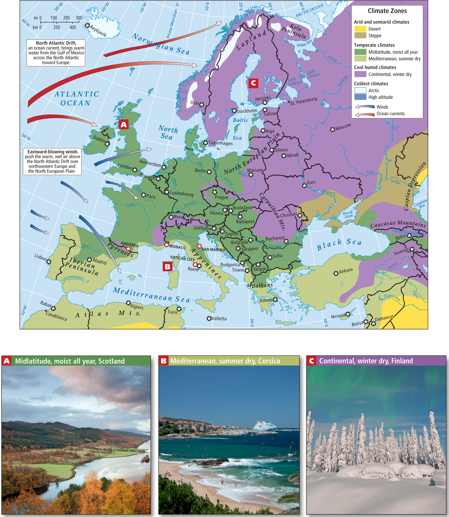
The air above the North Atlantic Drift is relatively warm and wet. Eastward-blowing winds push it over North and West Europe and the North European Plain, bringing moderate temperatures and rain deep into the Eurasian continent. These factors create a climate that, although still fairly cool, is much warmer than elsewhere in the world at similar latitudes. To minimize the effects of heavy precipitation runoff, people in these areas have developed elaborate drainage systems for their houses and communities. Forests are both evergreen and deciduous. There is some concern that global climate change could eventually weaken the North Atlantic Drift, leading to a significantly cooler Europe.
Mediterranean climate a climate pattern of warm, dry summers and mild, rainy winters
Farther to the south, the Mediterranean climate prevails—warm, dry summers and mild, rainy winters (see Figure 4.4B). In the summer, warm, dry air from North Africa shifts north over the Mediterranean Sea as far north as the Alps, bringing high temperatures and clear skies. Crops grown in this climate, such as olives and grapes, citrus, apple and other fruits, and wheat, must be drought-resistant or irrigated. In the fall, this warm, dry air shifts to the south and is replaced by cooler temperatures and rainstorms sweeping in off the Atlantic. Overall, the climate here is mild, and houses along the Mediterranean coast are often open and airy to afford comfort in the hot, sunny summers. During the short, mild winter, life moves indoors, where wood fires heat one or two small rooms.
humid continental climate a midlatitude climate pattern in which summers are fairly hot and moist, and winters become longer and colder the deeper into the interior of the continent one goes
In Central Europe, without the moderating influences of the Atlantic Ocean and the Mediterranean Sea, the climate is more extreme. In this region of humid continental climate, summers are fairly hot, and the winters become longer and colder the farther north or deeper into the interior of the continent one goes (see Figure 4.4C). Here, houses tend to be well insulated, with small windows, low ceilings, and steep roofs that can shed snow. Crops must be adapted for much shorter growing seasons, and include corn and other grains plus fruit trees and a wide variety of vegetables adapted to the cold, especially root crops and cabbages.
THINGS TO REMEMBER
 Europe is a region of peninsulas upon peninsulas.
- Europe has three main landforms—mountain chains, uplands, and the lowlands of the vast North European Plain.
- Europe has three principal climates—the temperate midlatitude, the Mediterranean climate, and the humid continental climate.