Physical Patterns
Many of the landforms, and even the climates, of South Asia are the result of huge tectonic forces. These forces have positioned the Indian subcontinent along the southern edge of the Eurasian continent, where the warm Indian Ocean surrounds it and the massive mountains of the Himalayas shield it from cold airflows from the north (see Figure 8.1).
Landforms
The Indian subcontinent and the territory surrounding it dramatically illustrate what can happen when two tectonic plates collide. Millions of years ago, the Indian-Australian Plate, which carries India, broke free from the eastern edge of the African continent and drifted to the northeast (see Figure 1.25). When this plate collided with the Eurasian Plate about 60 million years ago, it left a giant peninsula jutting into the Indian Ocean. As the relentless pushing from the south continued, both the leading (northern) edge of what became South Asia and the southern edge of Eurasia crumpled and buckled. The result is the world’s highest mountains—the Himalayas, which rise more than 29,000 feet (8800 meters)—as well as other mountain ranges that curve away from the central impact zone—in the west, the Hindu Kush and Karakoram Range and, in the east, the lesser-known ranges that border China and Burma (see Figure 8.1B and the figure map). The continuous compression also lifted up the Plateau of Tibet, which rose up behind the Himalayas to an elevation of more than 15,000 feet (4500 meters) in some places. The compression and mountain-building process continues into the present.
The three great rivers of South Asia—the Indus, the Ganga, and the Brahmaputra—all begin within 100 miles (160 kilometers) of one another in the Himalayan highlands near the Tibet, Nepal, and India borders; they are largely fed by glacial meltwater (see the Figure 8.1 map and Figure 8.5 map). The main river basins of the Indus and Ganga lie to the southwest and south of the Himalayas in what is called the Indo-Gangetic Plain (see Figure 8.1C, F). The Indus flows southwest through Pakistan and ultimately joins the Arabian Sea. The Ganga flows southeast to the Bay of Bengal. The Brahmaputra flows east through Tibet and then turns south through Arunachal Pradesh and Assam into Bangladesh. The mouths of the Ganga and Brahmaputra are blended together in a giant, ever-changing delta.
South of the Indo-Gangetic Plain lies the Deccan Plateau, an area of modest uplands (1000–2000 feet [300–600 meters] in elevation) interspersed with river valleys (see Figure 8.1E). This upland region is bounded on the east and west by two moderately high mountain ranges, the Eastern and Western Ghats (see Figure 8.1D). The Ghat mountain ranges descend to long but narrow coastlines interrupted by extensive river deltas and floodplains (see Figure 8.1A). The river valleys and coastal zones are densely occupied; the uplands are only slightly less so.
Because of its continual high degree of tectonic activity and deep crustal fractures, South Asia is prone to devastating earthquakes, such as the magnitude 7.7 quake that shook the state of Gujarat in western India in 2001, the 7.6 quake that hit the India–Pakistan border region in 2005, and the 6.4 quake in Quetta Province, Pakistan, in 2008, that left 120,000 people homeless. Coastal areas are also vulnerable to tidal waves, or tsunamis, that are caused by undersea earthquakes. In 2004, a massive tsunami originating off Sumatra in Southeast Asia wrecked much of coastal Sri Lanka and southern India (see Figure 8.1A), killing tens of thousands of people there and many more in Southeast Asia.  179. TOWN OF HAMBANTOTA, SRI LANKA, REGAINS SOME NORMALCY AFTER TSUNAMI A YEAR AGO
Climate and Vegetation
The climate of South Asia is characterized by a seasonal reversal of winds known as monsoons (Figure 8.4). These monsoon winds are affected by the intertropical convergence zone (ITCZ), which, as the name suggests, is a zone created when air masses moving south from the Northern Hemisphere and north from the Southern Hemisphere converge near the equator. As the warm air rises and cools, it drops copious amounts of precipitation. As described in Chapter 7, the ITCZ shifts north and south seasonally. The intense rains of South Asia’s monsoon are likely caused by the ITCZ being sucked onto the land by a vacuum created when huge air masses over the Eurasian continent heat up and rise into the upper troposphere.
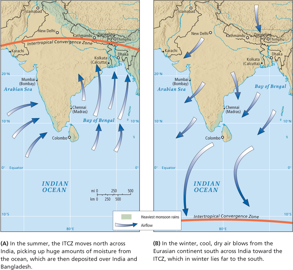
summer monsoon rains that begin every June when the moist ITCZ air first reaches the mountainous western Ghats
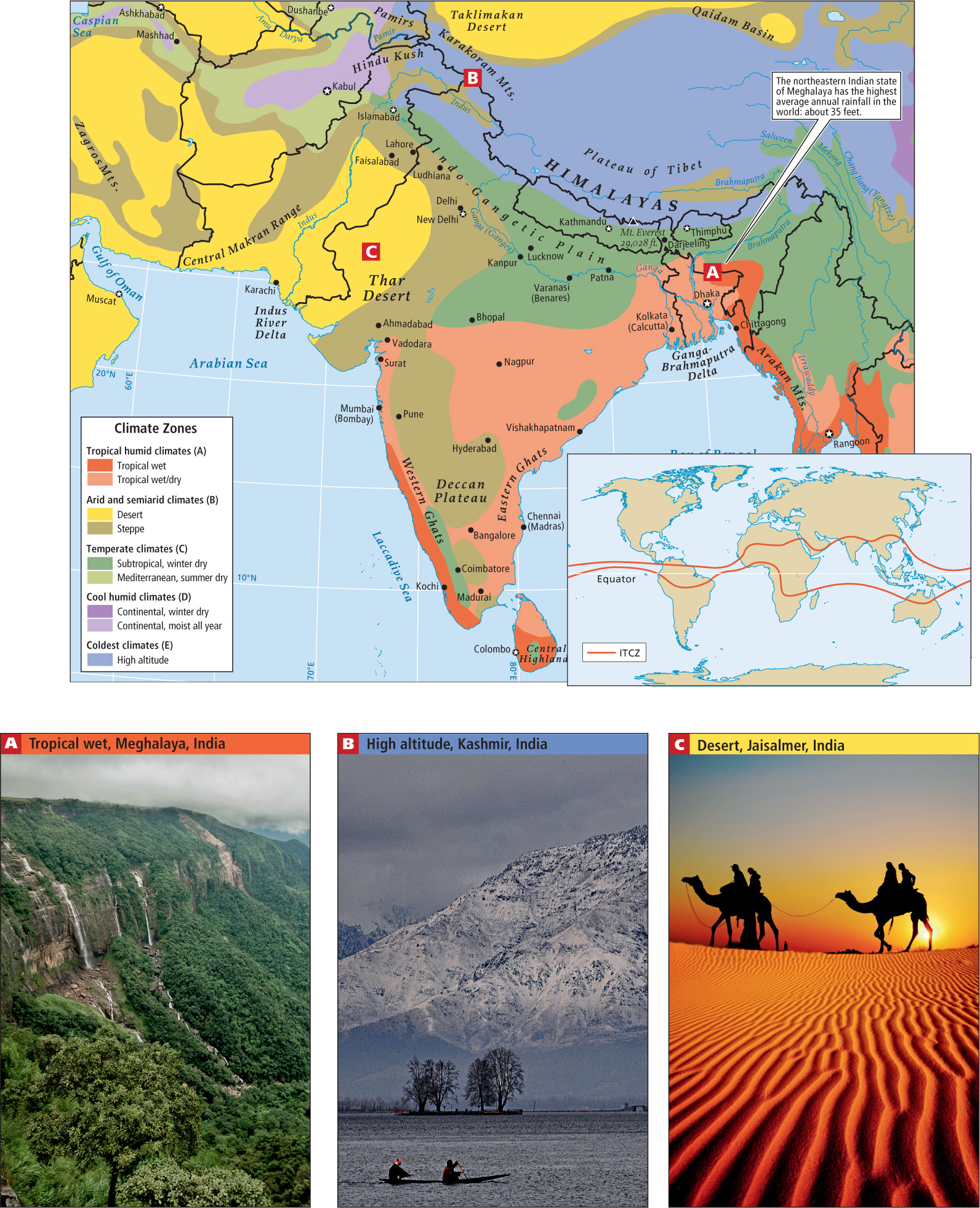
As the monsoon system reaches the hot plains of Bangladesh and the Indian state of West Bengal in late June, columns of warm, rising air create massive, thunderous cumulonimbus clouds that drench the parched countryside. Monsoon rains sweep east to west, parallel to the Himalaya Mountains, reaching across northern India to Pakistan and finally petering out over the Kabul Valley in eastern Afghanistan by July. Rainfall is especially intense in the east, north of the Bay of Bengal, where the town of Darjeeling holds the world record for annual rainfall—about 35 feet, even though no rain falls for half the year. These patterns of rainfall are reflected in the varying climate zones (shown in Figure 8.5) and agricultural zones of South Asia (see Figure 8.28). Although sufficient rain falls in central India to support forests, most land has long been cleared of forest (see the discussion) and planted in crops. Patches of forest in the uplands and lowlands are now so fragmented that they no longer provide suitable habitat for India’s wildlife. Forest vegetation is more common in the Himalayan highlands and foothills, but even in the mountains, human pressure has resulted in widespread deforestation, often leaving only patchy areas of formerly richly forested land.
Periodically, the monsoon seasonal pattern is interrupted and serious drought ensues. This happened in July and August of 2009, when the worst drought in 40 years struck much of South Asia (see the discussion below). Then in September of 2009, heavy rains came to central south India, causing crop-damaging floods that killed hundreds of people. Scientists are increasingly concluding that the extreme droughts and floods of recent years are not an anomaly but instead are part of the general global climate change.
winter monsoon a weather pattern that begins by November, when the cooling Eurasian landmass sends the cooler, drier, heavier air over South Asia
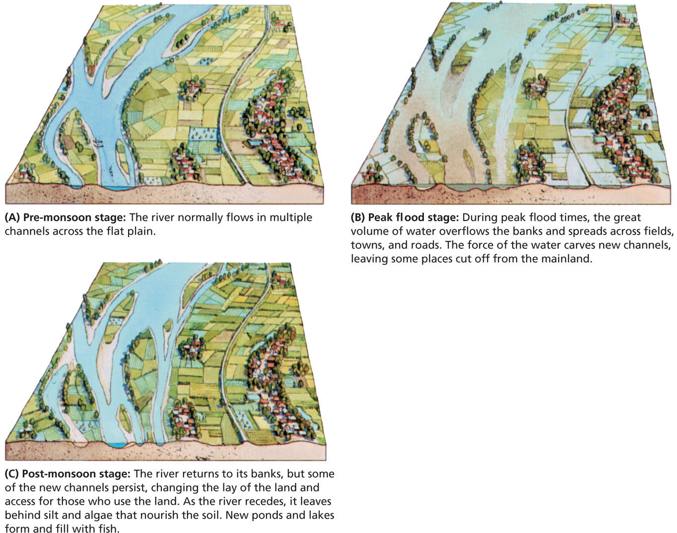
The monsoon rains deposit large amounts of moisture over the Himalayas, much of it in the form of snow and ice that add to the existing mass of glaciers (see Chapter 1). Meltwater from these glaciers feeds the headwaters of the Indus, the Ganga, and the Brahmaputra, which are then augmented by the many tributaries that flow into them. The rivers carry enormous loads of sediment, especially during the rainy season. When the rivers reach the lowlands, their velocity slows and much of the sediment settles out as silt. It is then repeatedly picked up and redeposited by successive floods. As illustrated in the diagram of the Brahmaputra River in Figure 8.6, the movement of silt constantly rearranges the floodplain landscape, and this complicates human settlement and agricultural efforts. However, the seasonal deposit of silt nourishes much of the agricultural production in the densely occupied plains of Bangladesh. The same is true on the Ganga and Indus plains.
THINGS TO REMEMBER
 Because of its high degree of tectonic activity and deep crustal fractures, all the countries of South Asia (Afghanistan, Pakistan, India, Nepal, Bhutan, Bangladesh, and Sri Lanka) are prone to devastating earthquakes.
- The three major rivers of this region originate from meltwater high in the northwest Himalaya Mountains and provide water to most of the region.
- The monsoons are a major influence on South Asia’s climate. In June, the warm, moist air of the summer monsoon reaches India, where coastal mountains and rising hot air force the moist monsoon air up, cooling it and causing rain. Monsoon rains run in a variable band parallel to the Himalayas that reaches across northern India and Pakistan, finally petering out over the Kabul Valley in eastern Afghanistan by July.
- Periodic interruptions of the monsoon rainfall patterns can result in devastating droughts.
- Precipitation from monsoons is especially intense in the eastern foothills of the Himalayas.
- The three main rivers carry enormous loads of sediment and deposit it as silt, a process that is repeated by successive floods. The movement of silt constantly rearranges the floodplain landscape, complicating human settlement and agricultural efforts.