9.2 PHYSICAL GEOGRAPHY AND ENVIRONMENTAL ISSUES
PHYSICAL PATTERNS
A quick look at the regional map of East Asia (see Figure 9.1) reveals that the topography here is perhaps the most rugged of any world region. East Asia’s varied climates result from the meeting of huge warm and cool air masses and the dynamic interaction between land and oceans. The region’s large human population has affected the variety of ecosystems that have evolved there over the millennia and that still contain many important and unique habitats.
Landforms
The complex topography of East Asia is partially the result of the slow-
The second step down from the Himalayas is a broad arc of basins, plateaus, and low mountain ranges (depicted in yellowish tan in the Figure 9.1 map). These landforms include the broad, rolling highland grasslands and deep, dry basins and deserts of western China (such as the Taklimakan Desert) and Mongolia (see Figure 9.1B), as well as the Sichuan Basin and the rugged Yunnan–
The third step, directly east of this upland zone, consists mainly of broad coastal plains and the deltas of China’s great rivers (shown in shades of green in the Figure 9.1 map). Starting from the south, this step is defined by three large lowland river basins: the Zhu Jiang (Pearl River) basin, the massive Chang Jiang basin (see Figure 9.1C), and the lowland basin of the Huang He on the North China Plain. Each of these rivers has a large delta. Despite the deltas being subject to periodic flooding, they have historically been used for agriculture. However, coastal cities have now spread into many of these deltas, filling in wetlands and farms with zones of dense population and industrialization (see Figure 9.20). Low mountains and hills (shown in light brown in the Figure 9.1 map) separate these river basins. China’s Far Northeast and the Korean Peninsula are also part of this third step.
The fourth step consists of the continental shelf, covered by the waters of the Yellow Sea, the East China Sea, and the South China Sea. Numerous islands—
The islands of Japan have a different geological origin: they are volcanic, not part of the continental shelf. They rise out of the waters of the northwestern Pacific in the tectonically active zone where the Pacific, Philippine, and Eurasian plates grind against one another. Lying along a portion of the Pacific Ring of Fire (see Figure 1.9), the entire Japanese island chain is particularly vulnerable to disastrous volcanic eruptions, earthquakes, and tsunamis (seismic sea waves). Volcanic Mount Fuji, the highest peak in the country and a recognizable national symbol (see Figure 9.1E), last erupted in 1707. However, the mountain is still classed as active, and deep internal rumblings have been detected since 2001. In March of 2011, the largest earthquake in recorded Japanese history (registering 9.2 on the Richter scale) hit off the coast of Honshu, Japan, near the city of Sendai. The quake and subsequent tsunami killed tens of thousands of people and damaged several nuclear reactors located on the coast, resulting in the second-
tsunami a large sea wave caused by an earthquake
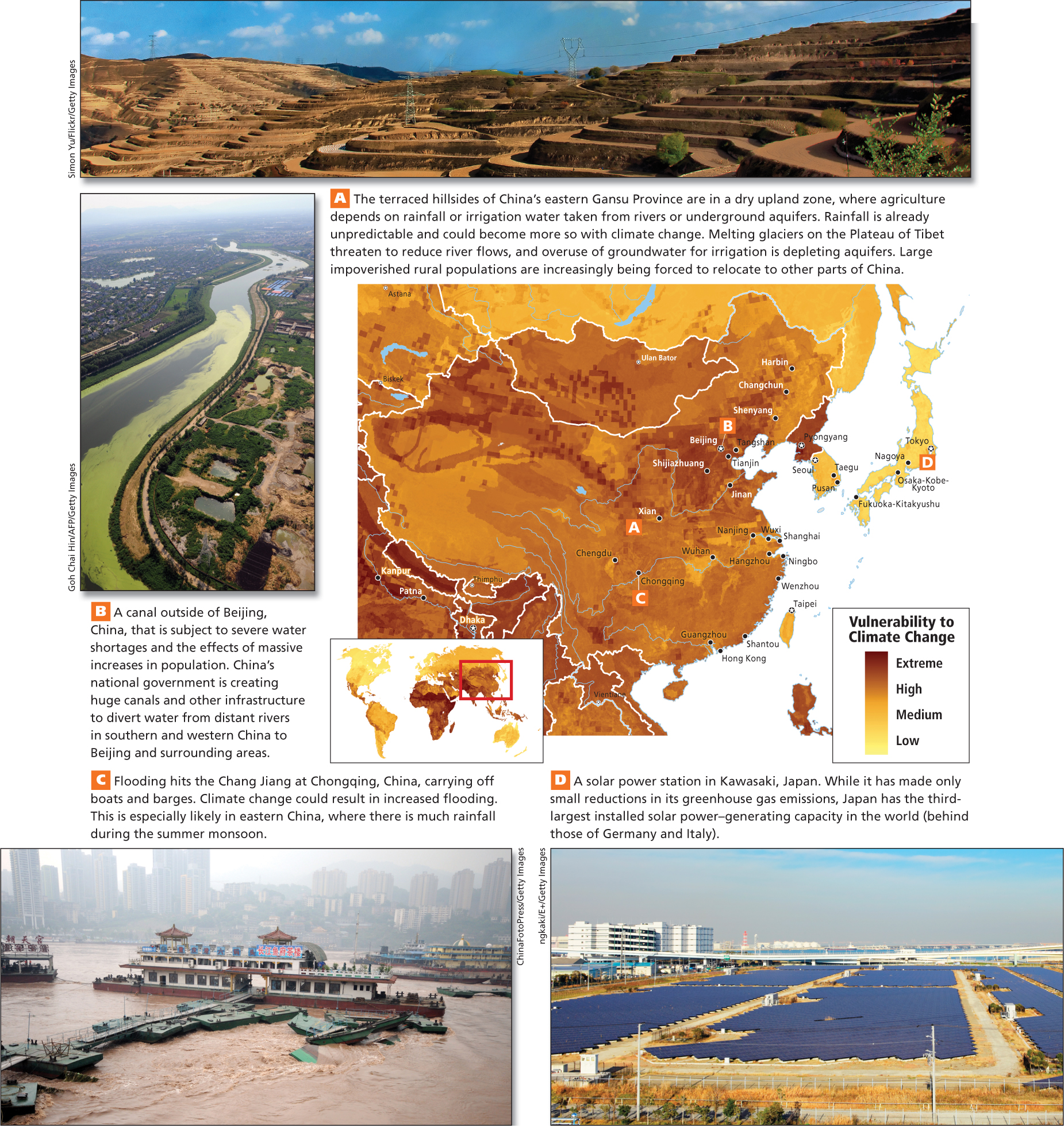
The East Asian landmass has few flat portions, and most flat land is either very dry or very cold. Consequently, the large numbers of people who occupy the region have had to be particularly inventive in creating spaces for agriculture. They have cleared and terraced entire mountain ranges, until recently using only simple hand tools (see Figure 9.5A). They have irrigated drylands with water from melted snow, drained wetlands using elaborate levees and dams, and applied their complex knowledge of horticulture and animal husbandry to help plants and animals flourish in difficult conditions.
THINKING GEOGRAPHICALLY
Use the Photo Essay above to answer these questions.
Question 9.1
A What is one process that can result from people beginning to live or farm in dry environments?
Question 9.2
B What is causing the water table to fall each year on the North China Plain?
Question 9.3
C Flooding is especially likely in what part of China?
Climate
East Asia has two principal contrasting climate zones, shown in the Figure 9.4 map: the dry interior west and the wet (monsoon) east. Recall from Chapter 8 that the term monsoon refers to the seasonal reversal of surface winds that flow from the Eurasian continent to the surrounding oceans during winter and from the oceans inland during summer.
The Dry Interior Because land heats up and cools off more rapidly than water does, the interiors of large landmasses in the midlatitudes tend to be intensely cold in winter and extremely hot in summer. Western East Asia, roughly corresponding to the first two topographic steps described earlier, is an extreme example of such a midlatitude continental climate because it is very dry. In fact, this area is farther away from an ocean than any other place on Earth’s surface (it is also known as a pole of inaccessibility). With little vegetation or cloud cover to retain the warmth of the sun after nightfall, summer daytime and nighttime temperatures may vary by as much as 100°F (55°C).
Grasslands and deserts of several types cover most of the land in this dry region (see Figure 9.4C). Only scattered forests grow on the few relatively well-
The Monsoon East The monsoon climates of the east are influenced by the extremely cold conditions of the huge Eurasian landmass in the winter and the warm temperatures of the surrounding seas and oceans in the summer. During the dry winter monsoon, descending frigid air sweeps south and east through East Asia, producing long, bitter winters on the Mongolian Plateau, on the North China Plain, and in China’s Far Northeast (see Figure 9.4D). While occasional freezes may reach as far as southern China, winters there are shorter and less severe. The cold air of the dry winter monsoon is partially deflected by the east–
As the continent warms during the summer monsoon, the air above it rises, pulling in wet, tropical air from the adjacent seas. The warm, wet air from the ocean deposits moisture on the land in the form of seasonal rains. As the summer monsoon moves northwest, it must cross numerous mountain ranges and displace cooler air. Consequently, its effect is weakened toward the northwest. Thus, the Zhu Jiang basin in the far southeast is drenched with rain and has warm weather for most of the year (see Figure 9.4A), whereas the Chang Jiang basin, which lies in central China to the north of the Nan Ling range, has about 5 months of summer monsoon weather. The North China Plain, north of the Qin Ling and Dabie Shan ranges, receives even less monsoon rain—
Korea and Japan have wet climates year-
Natural Hazards The entire coastal zone of East Asia is intermittently subject to typhoons (tropical cyclones or hurricanes). Japan’s location along the northwestern edge of the Pacific Ring of Fire (see Figure 1.9) results in volcanic eruptions, earthquakes, and tsunamis. These natural hazards are a constant threat in Japan; the heavily populated zone from Tokyo southwest through the Inland Sea (between Shikoku and southern Honshu) is particularly endangered. Earthquakes are also a serious natural hazard in Taiwan and in China’s mountainous interior.
typhoon a tropical cyclone or hurricane in the western Pacific Ocean
THINGS TO REMEMBER
There are four main topographical zones, or “steps,” that form the East Asian continent.
Japan was created by volcanic activity along the Pacific Ring of Fire.
East Asia has two principal contrasting climates: the dry continental interior (west) and the monsoon east.
East Asia faces a wide range of natural hazards, including earthquakes, tsunamis, volcanic eruptions, and tropical storms (typhoons).