Chapter 5
Climates and Soils
112

113
CHAPTER CONCEPTS
- Earth is warmed by the greenhouse effect.
- There is an unequal heating of Earth by the Sun.
- The unequal heating of Earth drives air currents in the atmosphere.
- Ocean currents also affect the distribution of climates.
- Smaller-scale geographic features can affect regional and local climates.
- Climate and the underlying bedrock interact to create a diversity of soils.
Where Does Your Garden Grow?
If you have planted a garden, you know that you have a lot of decisions to make. You can choose from a vast selection of fruits and vegetables, not to mention a dizzying array of flowers, shrubs, and trees. Although you have a large number of choices, not all plants grow well in all locations. To help gardeners determine what plants can survive and flourish in their location, the U.S. Department of Agriculture has developed a map of plant hardiness zones.
“To help gardeners determine what plants can survive and flourish in their location, the U.S. Department of Agriculture has developed a map of plant hardiness zones.”
Plant hardiness zones take into account the coldest temperatures that occur during the winter. The hardiest plants tolerate very cold temperatures whereas others are too sensitive to survive harsh winters. The plant hardiness zones follow the minimum temperature typically reached in locations throughout North America. Zone 10, for example, is found in southern Florida where the average minimum temperature in winter is above 4°C. In contrast, zone 1, with an average minimum winter temperature below –45°C, is found in Alaska.
In looking at the map of plant hardiness zones, several patterns emerge. First, there appears to be an ordering of zones that is related to latitude, particularly through the middle of the continent. Higher latitudes receive less sunlight in the winter and have lower winter temperatures. However, a second pattern of plant hardiness zones curves up along the coastlines. For instance, in the interior of the continent, zone 8 spans states such as Louisiana, Alabama, and Georgia. Along the east coast, however, zone 8 extends all the way up to Virginia. Along the west coast, zone 8 extends north, all the way through the state of Washington. These patterns occur because the two coasts are adjacent to oceans, which contain warm tropical waters that circulate up from the equator. These warm waters heat the air during winter and make the land along the coasts warmer than the interior of the continent at the same latitude. A third pattern can be seen in elevation; mountain tops have colder temperatures than lower elevations.
114
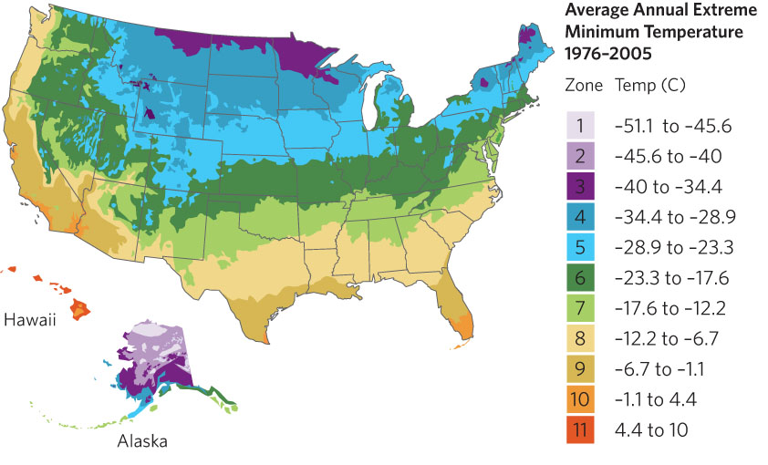
The hardiness zone map also shows that the west coast has warmer winter temperatures than the east coast. This allows farmers in California to grow fruits and vegetables during the winter. The difference in temperatures between the east and west coasts is caused by prevailing winds that blow from west to east. In the winter along the west coast, the winds carry the warmer ocean air toward the coast, making it warm. Along the east coast, however, winds carry cold air from the middle of the continent toward the coast and push the warm ocean air away from the coast. As a result, the east coast remains colder than the west coast during the winter.
The map of plant hardiness zones illustrates how climates around the world are the result of a complex combination of sunlight, latitude, elevation, air currents, and ocean currents. In this chapter, we will explore how global processes affect the distribution of climates on Earth and how climates affect the types of soils that form.
SOURCE: The United States National Arboretum, USDA Plant hardiness zone map, http://www.usna.usda.gov/Hardzone/ushzmap.html
 As we saw in Chapter 3, the climate of a region on Earth refers to the average atmospheric conditions measured over many years. Climates can range widely, from very cold areas near the North and South Poles, to hot and dry deserts at approximately 30° N and 30° S latitudes, to hot and wet areas near the equator. In this chapter, we will examine factors that determine the location of climates around the world. With an understanding of climates, we will move on to look at how soils are formed. As we will see in subsequent chapters, these differences in climates and soils help determine the distribution of organisms around the globe.
A number of factors contribute to the different climate patterns. Some of the most important are the greenhouse effect, the unequal heating of Earth by solar energy, atmospheric convection currents, the rotation of Earth, ocean currents, and a variety of smaller-scale topographic features, including rain shadows.