The unequal heating of Earth drives air currents in the atmosphere
Atmospheric convection currents The circulations of air between the surface of Earth and the atmosphere.
Earth’s uneven heating helps determine atmospheric convection currents, which are the circulations of air between the surface of Earth and the atmosphere. The patterns of air circulation play a major role in the location of tropical rainforests, deserts, and grasslands throughout the world. In this section, we will explore how the interaction of Earth’s unequal heating and the properties of air create atmospheric convection currents.
Properties of Air
Four properties of air influence atmospheric convection currents: density, water vapor saturation point, adiabatic heating or cooling, and latent heat release.
Like all gases, when air warms it expands and becomes less dense. When air next to the surface of Earth warms, it becomes less dense than the air above it. This causes the warm air next to the surface of Earth to rise.
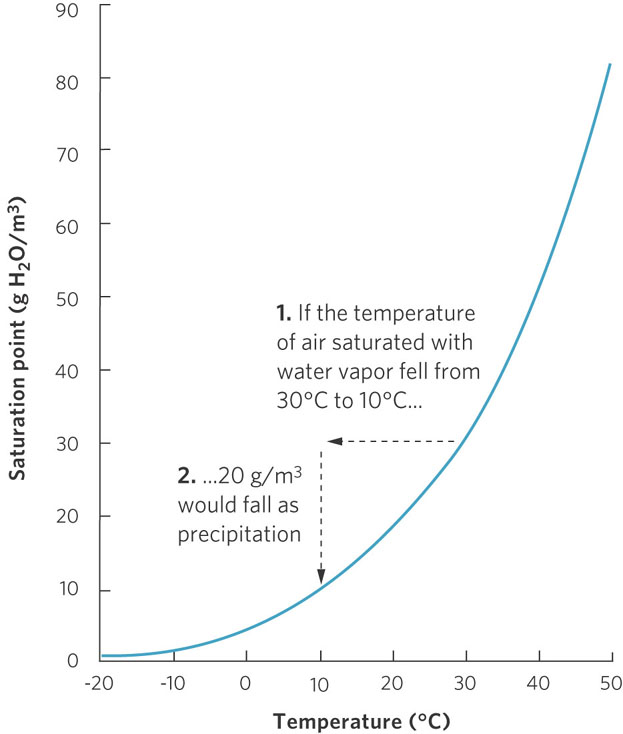
Saturation point The limit of the amount of water vapor the air can contain.
The graph in Figure 5.5 shows the relationship between air temperature and the maximum amount of water vapor that the air is able to contain. As air temperature increases, its capacity to contain water vapor—the gaseous form of water—increases. Although the capacity to contain water increases at higher temperatures, there is always a limit, known as the saturation point. When the water vapor content of air exceeds the saturation point, the excess condenses and changes phase to either liquid water or ice. When the water vapor content is below the saturation point, liquid water or ice can be converted to water vapor. For example, at 30°C, air can contain up to 30 g of water vapor per m3. Air that contains the maximum amount of water vapor has reached its saturation point. If the air at 30°C cools to 10°C, the saturation point of the air will decrease to 10 g of water vapor per m3. As a result, the excess vapor changes phase to liquid water or ice and produces clouds and precipitation.
120
If you live in a region with abundant water, you probably expect warm summer days to be humid. Evaporation from the ground and nearby bodies of water, as well as transpiration from plants, add water vapor to the air. However, if you live in a drier region, such as a desert, you know that the hottest days are not humid; a scarcity of water keeps the atmosphere from becoming saturated, and plants and animals face the threat of losing too much precious body water to the atmosphere. Under these conditions, plants close their stomata, which reduces the amount of water that can be moved into the atmosphere via transpiration.
The relationship between temperature and water vapor saturation affects patterns of evaporation and precipitation around the world. This, in combination with air currents, determines the distribution of wet and dry environments.
The movement of air in response to changes in pressure also influences convection currents. Near the surface of Earth, the gravitational pull on all molecules in the atmosphere brings many of the molecules close to Earth’s surface. An increase in the number of molecules causes an increase in air pressure near Earth’s surface. As one moves higher into the atmosphere, the air contains fewer total molecules, which lowers the air pressure. As a result, when air moves between the surface of Earth and the atmosphere, it experiences changes in pressure.
Adiabatic cooling The cooling effect of reduced pressure on air as it rises higher in the atmosphere and expands.
Air pressure is related to the frequency of collisions among air molecules, which also influences temperature. Lower rates of collision cause lower temperatures. As a result, when air moves higher up into the atmosphere and experiences lower pressure, the air expands and the temperature decreases—a process known as adiabatic cooling. Conversely, when air moves down to Earth’s surface and experiences higher pressure, the air compresses and the temperature increases in a process known as adiabatic heating.
Adiabatic heating The heating effect of increased pressure on air as it sinks toward the surface of Earth and decreases in volume.
Latent heat release When water vapor is converted back to liquid, water releases energy in the form of heat.
The final property of air to consider is the release of heat. As you might recall from our discussion of the thermal properties of water in Chapter 2, converting liquid water to water vapor requires a great deal of energy. In the reverse process, known as latent heat release, water vapor converted back to liquid water releases energy in the form of heat. Latent heat release is significant because whenever water vapor exceeds its saturation point, condensation will cause a release of heat that warms the surrounding air.
Formation of Atmospheric Convection Currents
Differences in climate are determined in part by patterns of worldwide air circulation. Let’s look at the equator during the March or September equinoxes. As you can see in Figure 5.6, solar energy warms the air at the surface of Earth. This warming causes the air to expand and rise. As air rises into regions of decreased atmospheric pressure, it expands. The temperature of the air then cools through the mechanism of adiabatic cooling. This cooled air has a reduced capacity to contain water vapor, so the excess water vapor condenses and falls back to Earth as rain. This process, in which the surface air heats, rises, and releases excess water vapor in the form of rain, is the primary reason that latitudes near the equator often experience high amounts of rainfall.
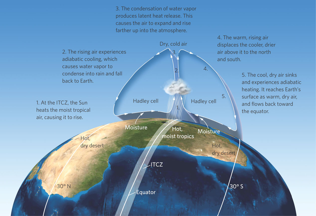
Returning to Figure 5.6, we can see that when the water vapor condenses, it causes latent heat release, which further warms the rising air. This enhances the upward motion of the air, condensation, and rainfall. As the air pressure continues to fall with rising altitude, the air temperature continues to drop. At this altitude, the cool, dry air is pushed from below by more rising air and begins to move horizontally toward the poles.
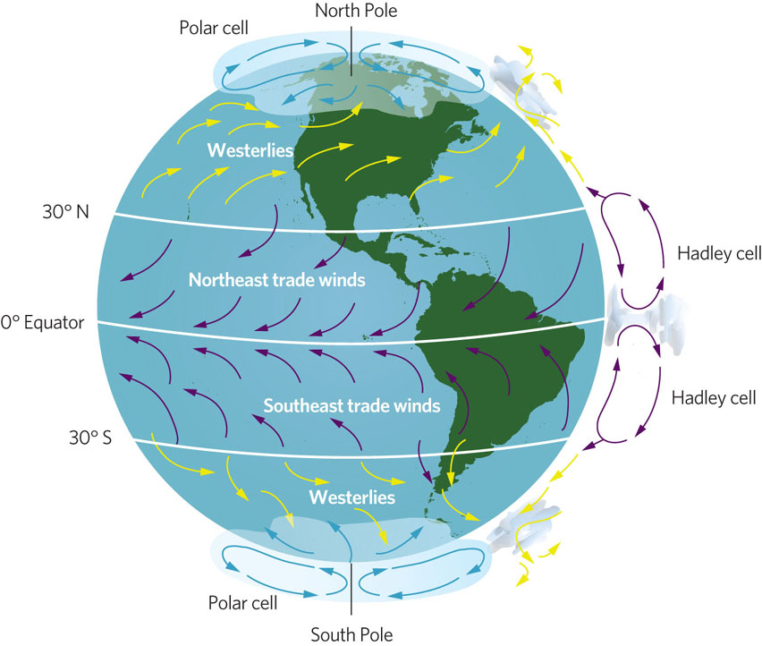
Hadley cells The two circulation cells of air between the equator and 30° N and 30° S latitudes.
The upward movement of air is the driving force behind atmospheric convection currents, but it is just the first of a series of steps in the process. Once the cool, dry air is displaced horizontally toward the poles, it begins to sink back toward Earth at approximately 30° N and 30° S latitudes. As Figure 5.6 illustrates, this air sinks toward Earth where increased pressure causes it to compress. As the air compresses, it experiences adiabatic heating and decreased humidity. By the time the air falls back to the surface of Earth, it is hot and dry. This explains why many of the major deserts of the world—which are characterized by hot, dry air—are located at approximately 30° N and 30° S latitudes. Once this hot, dry air reaches the ground, it flows back toward the equator, completing the air circulation cycle. The two circulation cells of air between the equator and 30° N and 30° S latitudes are known as Hadley cells. The area where the two Hadley cells converge and cause large amounts of precipitation is known as the intertropical convergence zone (ITCZ).
Intertropical convergence zone (ITCZ) The area where the two Hadley cells converge and cause large amounts of precipitation.
121
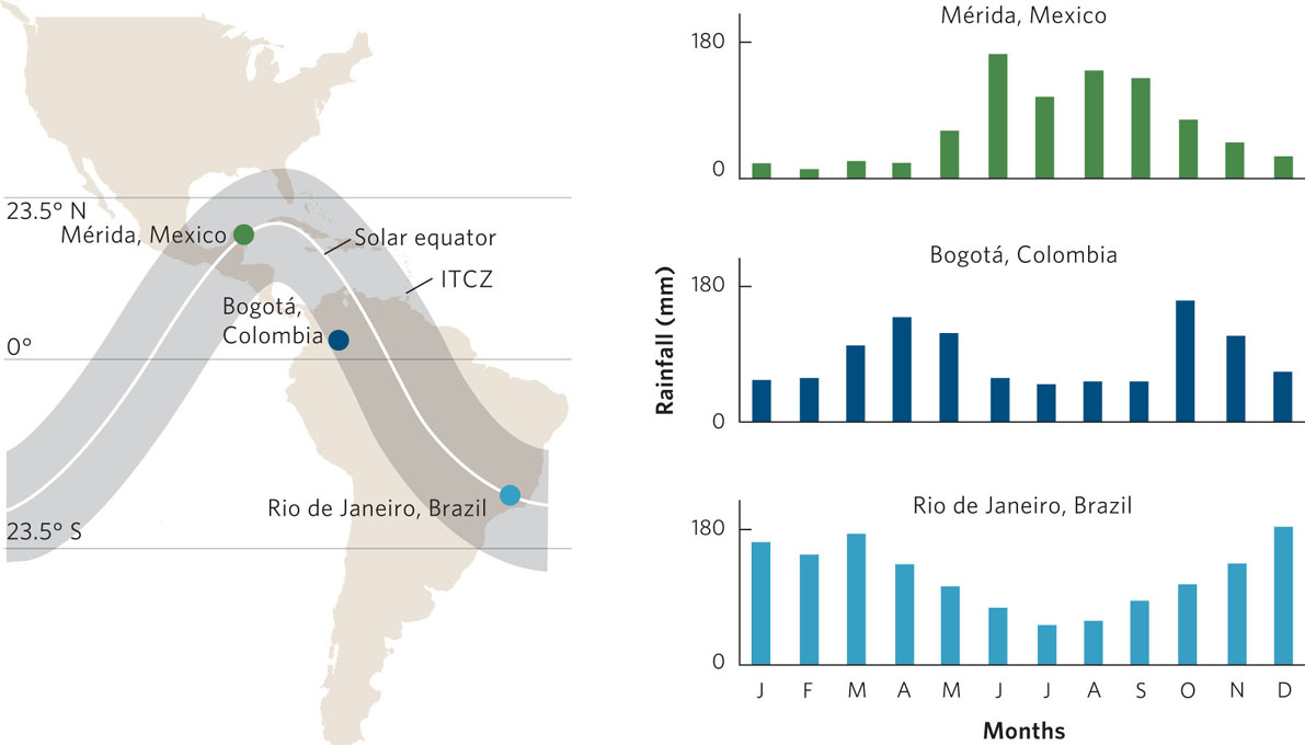
The intense sunlight at the solar equator drives the Hadley cells and the ITCZ, causing the warmed air to rise and precipitation to be released in the form of rain. As we saw in our earlier discussion about unequal seasonal heating of Earth, we know that the solar equator shifts throughout the year, from 23.5° N latitude in June to 23.5° S latitude in December. Because the latitude of the solar equator determines the latitude of the ITCZ, the latitude of the ITCZ also moves throughout the year. This means that the seasonal movement of the solar equator influences seasonal patterns of rainfall. The seasonal movement of the ITCZ between the Tropic of Cancer and the Tropic of Capricorn leads to one pronounced rainy season over most of the tropics and subtropics. In contrast, latitudes near the equator experience two pronounced rainy seasons because the ITCZ passes over the equator in March and September.
You can see the effect of the ITCZ movement in Figure 5.7 by examining the patterns of rainfall across three locations in the Western Hemisphere. The city of Mérida, Mexico, lies about 20° N of the equator. The intertropical convergence reaches Mérida only during June, which is why June is the rainy season for Mérida. In comparison, Rio de Janeiro, Brazil, lies about 20° S latitude. The intertropical convergence reaches Rio de Janeiro in December, which is the middle of the rainy season for that city. Close to the equator, in Bogotá, Colombia, the intertropical convergence zone passes overhead twice each year, during the March and September equinoxes. As a result, Bogotá experiences two rainy seasons.
122
Polar cells The atmospheric convection currents that move air between 60° and 90° latitudes in the Northern and Southern Hemispheres.
The pattern of air circulation near the equator also exists near the two poles. At approximately 60° N and 60° S latitudes, air rises up into the atmosphere and drops moisture. The cold, dry air then moves toward the poles and sinks back to Earth at approximately 90° N and 90° S latitudes. This air then moves along the ground back to 60° N and 60° S latitudes where it rises again. The atmospheric convection currents that move air between 60° and 90° latitudes are called polar cells.
Between the Hadley cells and polar cells, from latitudes of approximately 30° to 60°, is an area of air circulation that lacks distinct convection currents. In this range of latitudes in the Northern Hemisphere—which includes much of the United States, Canada, Europe, and Central Asia—some of the warm air from the Hadley cells that descends at 30° latitude moves toward the North Pole while some of the cold air from the polar cells that is traveling toward 60° moves toward the equator. The movement of air in this region also helps redistribute the warm air of the tropics and the cold air of the polar regions toward the middle latitudes.
The region between Hadley cells and polar cells can have dramatic changes in wind direction and, therefore, can experience large fluctuations in temperature and precipitation. However, winds generally move from west to east. This wind direction contributes to warmer conditions on the west coast of North America than on the east coast, as you can see from the plant hardiness zones.
Earth’S Rotation and the Coriolis Effect
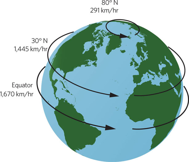
Hadley cells and polar cells are important drivers of wind direction on Earth. However, wind direction is also affected by the speed of Earth’s rotation, which changes with latitude. Earth completes a single rotation in 24 hours. Because the circumference of the planet at the equator is much larger than its circumference near the poles, the speed of rotation is faster at the equator. As Figure 5.8 shows, an object at the equator rotates at 1,670 km/hr, an object at 30° N rotates at 1,445 km/hr, and an object at 80° N rotates at 291 km/hr.
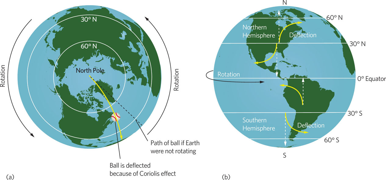
The different rotation speeds deflect the direction of surface air circulation in the Hadley and polar cells. Imagine standing at the North Pole and throwing a baseball straight south to the equator, as shown in Figure 5.9. While the ball is flying through the air, the planet continues to rotate. As a result, the ball does not land straight south at the equator. Instead, it travels along a path that appears to deflect to the west. In fact, the ball is traveling straight, but because the planet rotates while the ball is in motion, the ball lands west of its intended target. With respect to the planet, the ball’s path appears to be deflected. The deflection of an object’s path due to the rotation of Earth is known as the Coriolis effect.
Coriolis effect The deflection of an object’s path due to the rotation of Earth.
123
The deflected path of the ball in our example mimics the Coriolis effect on air moving to the north or south. For example, Hadley cells north of the equator move air along the surface from north to south. As we can see in Figure 5.10, the Coriolis effect causes this path to deflect so that it moves from the northeast to the southwest. These winds are known as the northeast trade winds. Below the equator, the Hadley cells are moving air along the ground from the south to the equator. The Coriolis effect causes this path to deflect so that it moves from the southeast to the northwest. These winds are known as the southeast trade winds. A similar phenomenon occurs in the polar cells. In the latitudes between Hadley cells and polar cells, wind direction can be quite variable. However, these winds often move away from the equator and toward the poles, only to be deflected by the Coriolis effect. This causes winds known as westerlies. Thus, weather in the middle latitudes tends to move from west to east. When considering the Coriolis effect, the general rule is that surface winds are deflected to the right in the Northern Hemisphere and to the left in the Southern Hemisphere.