Ocean currents also affect the distribution of climates
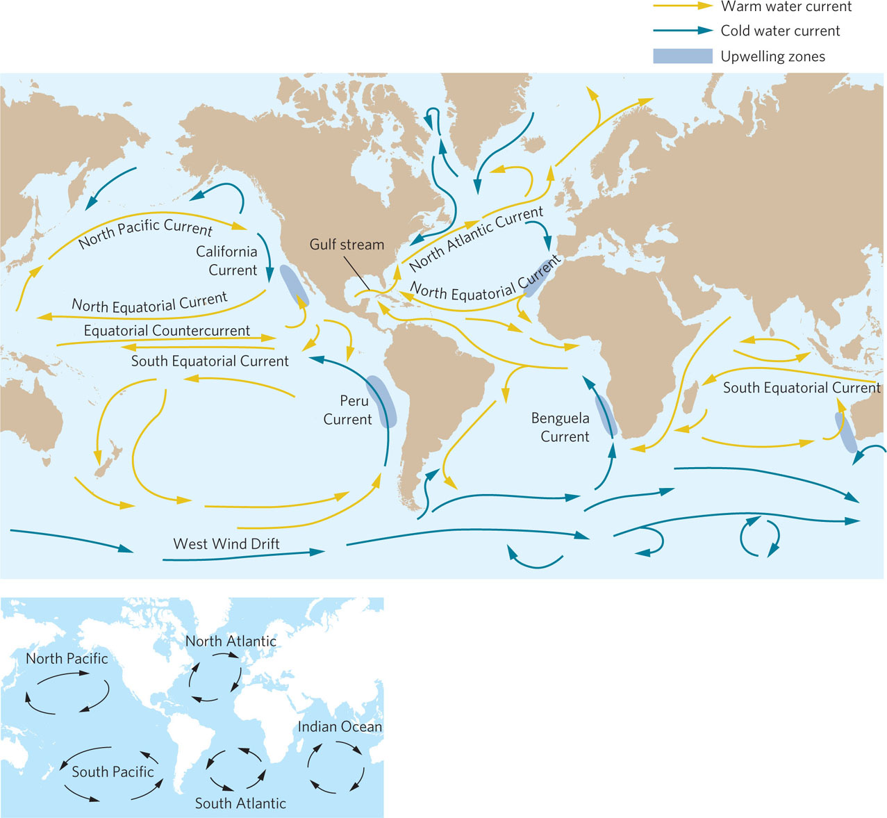
Like air currents, ocean currents distribute unequal heating of Earth’s water and therefore influence the location of different climates. Figure 5.11 shows some general patterns of circulation: warm tropical water circulates up through the western reaches of ocean basins toward the poles and the cold polar water circulates down the eastern edges of ocean basins toward the tropics. Many factors create these currents, including unequal heating, Coriolis effects, predominant wind directions, the topography of the ocean basins, and differences in salinity. In this section, we will examine the drivers of major ocean currents including gyres and upwelling. We will then investigate how natural changes in ocean currents can have large effects on global climates through a process known as the El Niño–Southern Oscillation. Finally, we will explore the thermohaline ocean circulation, a deep ocean current that can take hundreds of year to complete a single path around the globe.
124
Gyres
We have noted how tropical regions of Earth receive more direct sunlight than regions at higher latitudes. This causes ocean waters near the equator generally to be warmer than ocean waters at higher latitudes. Because of the unequal heating, the tropical waters expand as they warm. This expansion causes the water near the equator to be approximately 8 cm higher in elevation than the water in mid-latitudes. Although the difference may seem small, it is enough for the force of gravity to cause movement of water away from the equator.
Gyre A large-scale water circulation pattern between continents.
Around the globe, ocean circulation patterns are also affected by the dominant wind directions and Coriolis effects. North of the equator, for example, the northeast trade winds push surface water from the northeast to the southwest. At the same time, the Coriolis forces deflect ocean currents to the right. The combination of the two forces causes tropical water above the equator to move from east to west. The topography of ocean basins, particularly the locations of continents, causes these currents to change their direction. At mid-latitudes, the westerlies push surface waters to the northeast. As this occurs, Coriolis forces deflect the ocean currents to the right, which causes the ocean currents to move from west to east at mid-latitudes in the Northern Hemisphere. These large-scale water circulation patterns between continents are called gyres. The direction of the deflections caused by Coriolis forces depends on latitude; gyres move in a clockwise direction in the Northern Hemisphere and in a counterclockwise direction in the Southern Hemisphere.
Gyres redistribute energy by transporting both warm and cold ocean water around the globe. The proximity of these ocean waters to continents can make the continents considerably warmer or colder and therefore influence terrestrial climates. For example, England and Newfoundland, Canada, are at similar latitudes. However, England is adjacent to a warm-water current, the Gulf Stream, that comes out of the Gulf of Mexico, whereas Newfoundland is adjacent to a cold-water current that comes down from the west side of Greenland and pushes the warmer Gulf Stream water offshore. As a result, England experiences winter temperatures that are on average 20°C warmer than Newfoundland.
125
Upwelling
Upwelling An upward movement of ocean water.
Any upward movement of ocean water is referred to as upwelling. Illustrated as dark blue areas in Figure 5.11, upwelling occurs in locations along continents where surface currents move away from the coastline. As surface water moves away from land, cold water from beneath is drawn upward. Strong upwelling zones occur on the western coasts of continents where gyres move surface currents toward the equator and then veer from the continents. As surface water moves away from the continents, it is replaced by water rising from greater depths. Because deep water tends to be rich in nutrients, upwelling zones are often regions of high biological productivity. Major commercial fisheries are often located in these zones.
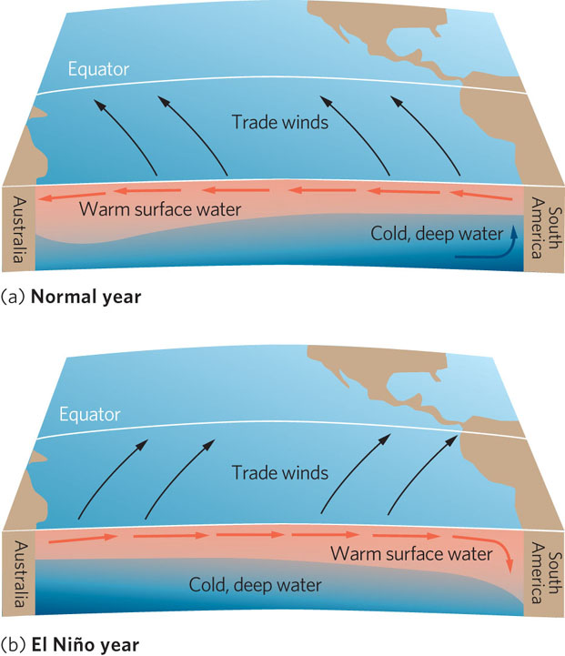
The El NiÑo–Southern Oscillation
El Niño–Southern Oscillation (ENSO) The periodic changes in winds and ocean currents in the South Pacific, causing weather changes throughout much of the world.
Sometimes ocean currents are substantially altered and this can affect climatic conditions. One of the best-known examples is the El Niño–Southern Oscillation (ENSO), which is illustrated in Figure 5.12. During most years in the South Pacific Ocean, southeast trade winds and Coriolis forces push the surface waters of the Peru Current that cause them to flow northwest along the west coast of South America with upwelling of cold water along the coast. Equatorial winds—powered by high air pressures in the eastern Pacific and low air pressures in the western Pacific—then push these surface waters offshore at Ecuador and west across the Pacific Ocean. As this water moves west, it warms. This warm water drives thunderstorm activity in the western Pacific, which results in high amounts of precipitation.
126
Every 3 to 7 years, however, this series of events changes. In the atmosphere, the normal difference in air pressures reverses and the equatorial winds weaken. In some years, these winds can even reverse direction. This change in air pressures in the Southern Hemisphere is the Southern Oscillation element of the ENSO. With either weakened or reversed equatorial winds, the warm surface waters of the western Pacific move east toward South America. As a result, the upwelling of nutrients shuts down and the normally productive fisheries in the area become much less productive. The accumulating warm water also serves as a source of increased precipitation for this region. The unusually warm water is the El Niño (“the baby boy”) element of the ENSO, so named because it typically occurs around Christmas time.
Because air and water currents are responsible for distributing energy throughout the world, the effects of an ENSO event extend over much of the world. For example, a strong ENSO event in 1982 to 1983 disrupted fisheries and destroyed kelp beds in California, caused reproductive failure of seabirds in the central Pacific Ocean, and killed off large areas of coral in Panama. Precipitation was also dramatically affected in many terrestrial ecosystems. Another ENSO event from 1991 to 1992—one of the strongest on record—was accompanied by the worst drought of the twentieth century in Africa, which caused poor crop production and widespread starvation. The event also brought extreme dryness to many areas of tropical South America and Australasia. Heat and drought in Australia reduced populations of red kangaroos to less than half their pre-ENSO levels. The El Niño event of 1997 to 1998 was blamed for 23,000 human deaths—mostly from famine—and $33 billion in damages to crops and property worldwide.
Outside the tropics and subtropics, ENSO events tend to increase precipitation, which boosts the production of natural and agricultural systems but also causes flooding. In North America, ENSO events bring cooler, wetter, and often stormy weather to the southern United States and northern Mexico, and warm, dry conditions to the northern United States and southern Canada.
Thermohaline Circulation
Ocean currents are also driven by the thermohaline circulation, a global pattern of surface- and deep-water currents that flow as a result of variations in temperature and salinity that change the density of water. The thermohaline circulation, shown in Figure 5.13, is responsible for the global movement of great masses of water between the major ocean basins. As wind-driven surface currents—for example, the Gulf Stream—move toward higher latitudes, the water cools and becomes denser. In the far north, toward Iceland and Greenland, the surface of the ocean freezes in winter. Because ice does not contain salts, the salt concentration of the underlying water rises, which causes the cold water to become even denser. This high-density water begins to sink and acts as the driving force behind a deep-water current in the Atlantic Ocean known as the North Atlantic Deep Water. Similar sinking currents are formed around the edges of Antarctica in the Southern Ocean. These cold, dense waters then flow through the deep ocean basins and back into equatorial regions, where they eventually surface as upwelling currents. These upwelling currents become warm and begin to make their way back to the North Atlantic. Like a giant conveyor belt, the thermohaline circulation slowly redistributes energy and nutrients among the oceans of the world in a trip that can take hundreds of years.
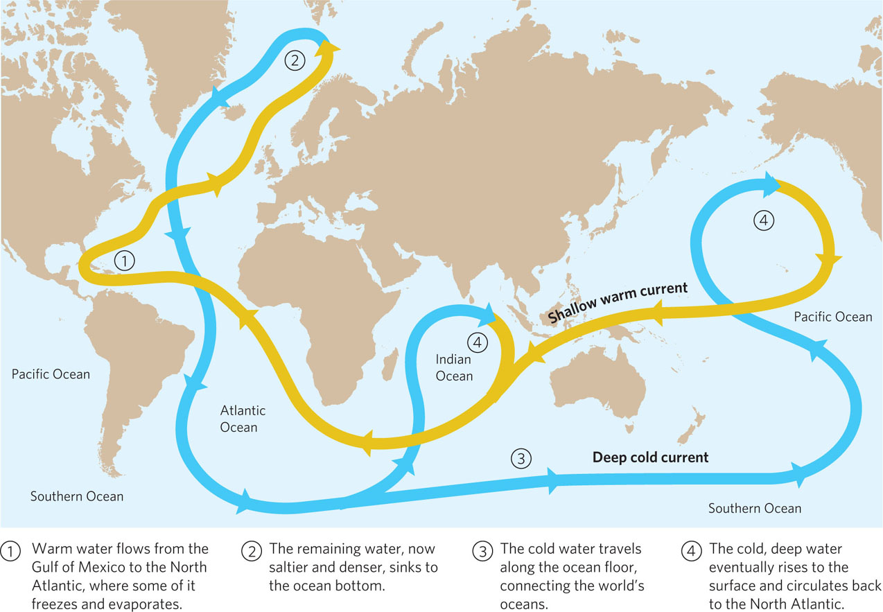
Thermohaline circulation A global pattern of surface- and deep-water currents that flow as a result of variations in temperature and salinity that change the density of water.
127