Aquatic biomes are categorized by their flow, depth, and salinity
As we discussed earlier in this chapter, ecologists categorize aquatic biomes using a range of physical factors including water depth, water flow, and salinity. The major types of aquatic biomes include streams and rivers, lakes and ponds, freshwater wetlands, salt marshes, mangrove swamps, intertidal zones, coral reefs, and the open ocean.
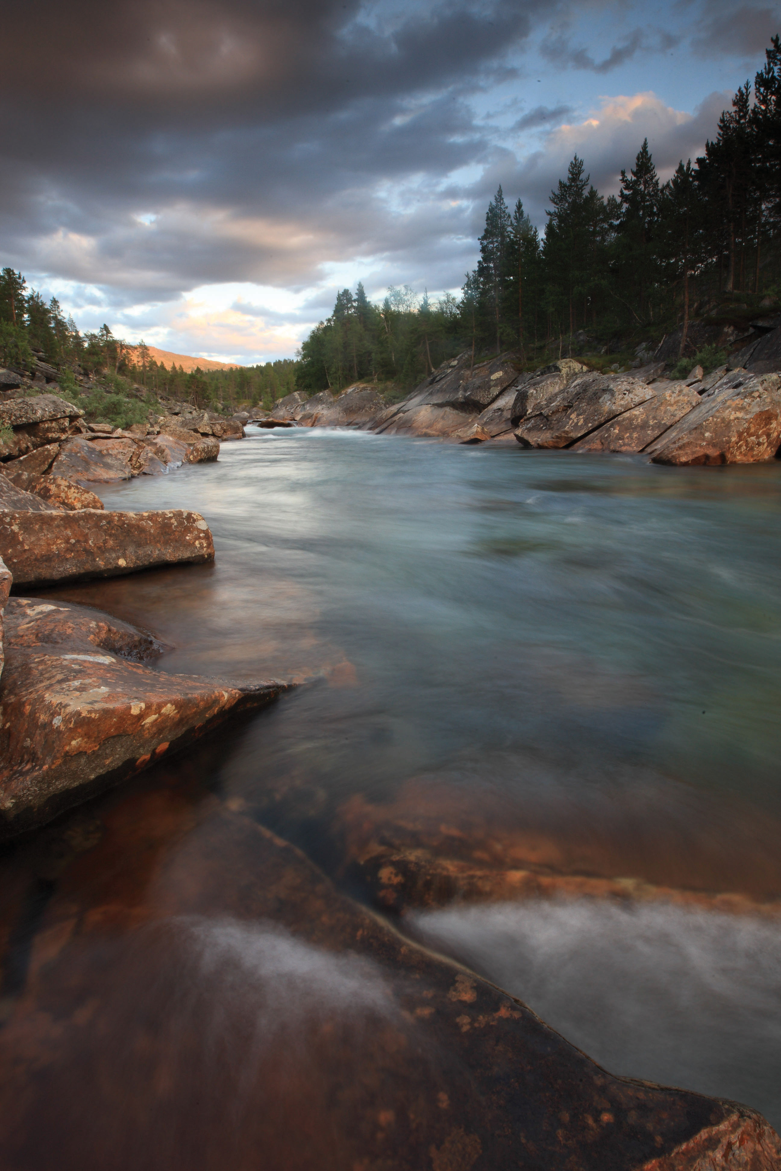
Streams and Rivers
Lotic Characterized by flowing fresh water.
Because streams and rivers are characterized by flowing fresh water, they are often referred to as lotic systems. Although there is no exact specification to determine classification differences between a stream and a river, in general, streams, also called creeks, are narrow channels of fast flowing fresh water whereas rivers are wide channels of slow flowing fresh water (Figure 6.14). As streams flow down from their headwaters, they join together with other streams and eventually grow large enough to be considered a river. Streams and some rivers are usually bordered by a riparian zone, which is a band of terrestrial vegetation influenced by seasonal flooding and elevated water tables.
Stream A narrow channel of fast flowing fresh water. Also known as Creek.
River A wide channel of slow flowing fresh water.
Riparion Zone A band of terrestrial vegetation alongside rivers and streams that is influenced by seasonal flooding and elevated water tables.
149
Allochthonous Inputs of organic matter, such as leaves, that come from outside of an ecosystem.
As one moves downstream, water flows more slowly and becomes warmer and richer in nutrients. Under these conditions, ecosystems generally become more complex and more productive. In general, streams support fewer species than other aquatic biomes. Small streams are often shaded and nutrient poor, which limits the productivity of algae and other photosynthetic organisms. Much of the organic content of stream ecosystems depends on allochthonous inputs of organic matter, such as leaves, that come from outside the ecosystem. In large rivers, a higher proportion of the organic inputs are autochthonous, meaning that they are produced from inside the ecosystem by algae and aquatic plants. As rivers progress from their source, they typically become wider, slower moving, more heavily laden with nutrients, and more exposed to direct sunlight. They also accumulate sediments that are washed in from the land and carried downstream. High turbidity caused by suspended sediments in the lower reaches of silt-laden rivers can block light and reduce production.
Autochthonous Inputs of organic matter that are produced by algae and aquatic plants inside an ecosystem.
Lotic systems are extremely sensitive to modification of their water flow by dams. In the United States, tens of thousands of dams—built to control flooding, to provide water for irrigation, or to generate electricity—interrupt stream flow. Dams also alter water temperature and rates of sedimentation. Typically, water behind dams becomes warmer, and the original stream bottoms become filled with silt that destroys habitat for fish and other aquatic organisms. Water released downstream from large dams often has low concentrations of dissolved oxygen. Using dams for flood control changes the natural seasonal cycles of flooding that are necessary for maintaining many kinds of riparian habitats on floodplains. Dams also disrupt the natural movement of aquatic organisms upstream and downstream, fragmenting river systems and isolating populations.
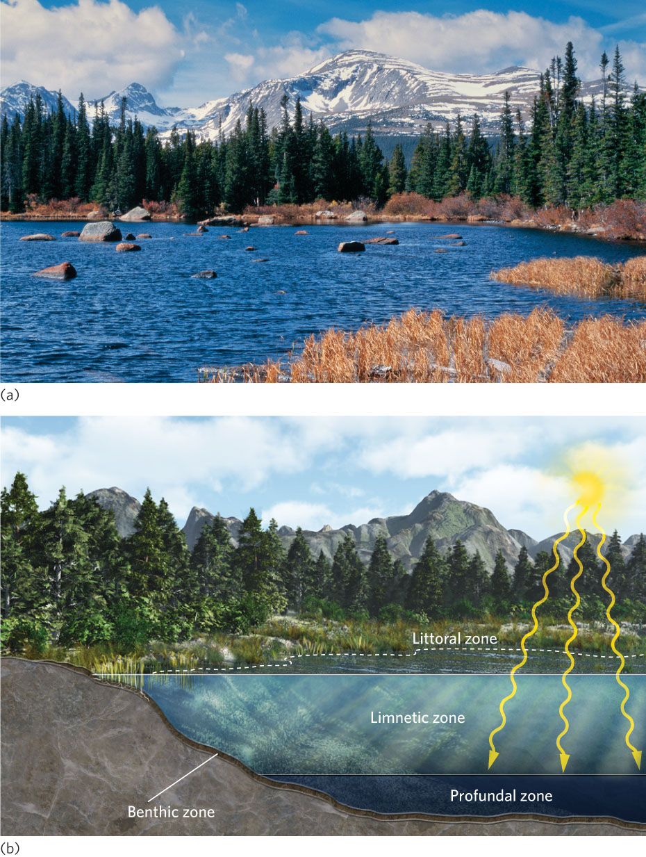
Ponds and Lakes
Pond An aquatic biome that is smaller than a lake and is characterized by nonflowing fresh water with some area of water that is too deep for plants to rise above the water’s surface.
Ponds and lakes are aquatic biomes characterized by nonflowing fresh water with at least some area of water that is too deep for plants to rise above the water’s surface (Figure 6.15a). Although there is no clear-cut distinction between ponds and lakes, ponds are smaller. Many lakes and ponds were formed as glaciers retreated, gouging out basins and leaving behind glacial deposits containing blocks of ice that eventually melted. The Great Lakes of North America formed in glacial basins, overlain until 10,000 years ago by thick ice. Lakes are also formed in geologically active regions, such as the Great Rift Valley of Africa, where vertical shifting of blocks of the Earth’s crust created basins in which water accumulates. Broad river valleys, such as those of the Mississippi and Amazon rivers, have oxbow lakes, which are broad bends of what was once the river, cut off by shifts in the main channel.
Lake An aquatic biome that is larger than a pond and is characterized by nonflowing fresh water with some area of water that is too deep for plants to rise above the water’s surface.
150
Littoral zone The shallow area around the edge of a lake or pond containing rooted vegetation.
As shown in Figure 6.15b, lakes can be subdivided into several ecological zones, each with distinct physical conditions. The littoral zone is the shallow area around the edge of a lake or pond containing rooted vegetation, such as water lilies and pickerelweed. The open water beyond the littoral zone is the limnetic (or pelagic) zone, where the dominant photosynthetic organisms are floating algae, or phytoplankton. Very deep lakes also have a profundal zone that does not receive sunlight because of its depth. The absence of photosynthesis, as well as the presence of bacteria that decompose the detritus at the bottom of the lake, causes the profundal zone to have very low concentrations of oxygen. The sediments at the bottoms of lakes and ponds constitute the benthic zone, which provides habitat for burrowing animals and microorganisms.
Limnetic zone The open water beyond the littoral zone, where the dominant photosynthetic organisms are floating algae. Also known as Pelagic zone.
Profundal zone The area in a lake that is too deep to receive sunlight.
Benthic zone The area consisting of the sediments at the bottoms of lakes, ponds, and oceans.
151
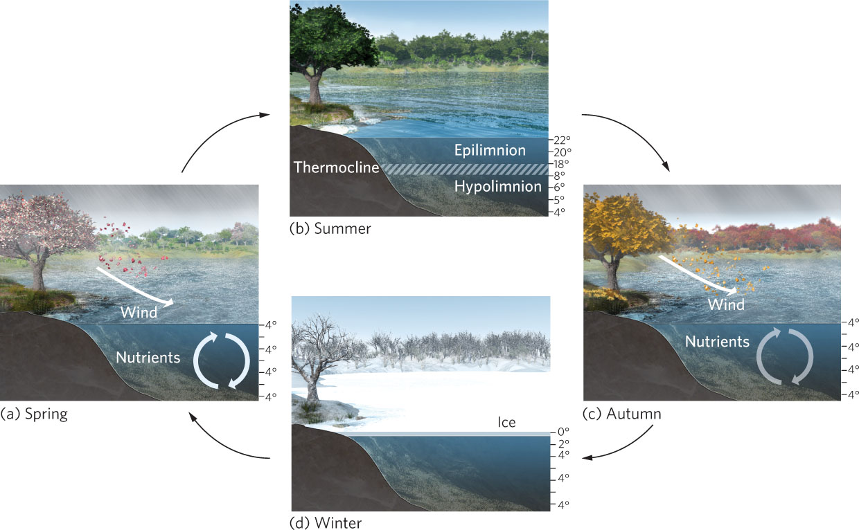
Circulation in Ponds and Lakes
Epilimnion The surface layer of the water in a lake or pond.
While lakes and ponds can be separated into four separate zones based on the proximity to the shore and the amount of light penetration, the water depths can also be classified by temperature. In most lakes and ponds in temperate and polar regions, the temperature of the water forms layers. The surface water, known as the epilimnion, can have a different temperature than the deeper water, known as the hypolimnion. Between these two temperature regions is the thermocline, which is a middle depth of water that experiences a rapid change in temperature over a relatively short distance in depth. The thermocline serves as a barrier to a mixing between the epilimnion and hypolimnion.
Hypomnion The deeper layer of water in a lake or pond.
Thermocline A middle depth of water in a lake or pond that experiences a rapid change in temperature over a relatively short distance in depth.
Most production in a lake occurs in the epilimnion, where sunlight is most intense. Oxygen produced by photosynthesis and oxygen entering the lake at the interface of the water and atmosphere keep the epilimnion well aerated and thus suitable for animal life. Throughout a growing season, however, plants and algae often deplete the supply of dissolved mineral nutrients in the epilimnion and this curtails their growth. In the hypolimnion, which can include the lower limnetic zone and the profundal zone, bacteria continue to decompose organic material, but the reduced intensity of light causes a reduction in photosynthesis. The result is that oxygen is used up faster than it is produced and this leads to anaerobic conditions. Oxygen is in particularly short supply deep in productive lakes that generate abundant organic matter in the epilimnion.
Spring overturn The vertical mixing of lake water that occurs in early spring, assisted by winds that drive the surface currents.
Lakes in the temperate zone experience changing temperatures across the seasons. These temperature changes drive changes in water density, which, in turn, causes the shallow and deep water to mix. Figure 6.16 shows this process. As you may recall from Chapter 2, water becomes more dense as it cools to 4°C and then less dense as it cools below 4°C. During the winter in cold climates, the coldest lake water (0°C) lies at the surface just beneath the ice, while the slightly warmer, denser water (4°C) sinks to the bottom of the lake. In early spring, the sun gradually warms the lake. As the surface temperature increases toward 4°C, the sun-warmed water sinks into the cooler layers immediately below and the water begins to mix. At the same time, winds drive surface currents that can cause deep water to rise in a manner similar to upwelling currents in the oceans. The vertical mixing of the lake water that occurs in early spring and is assisted by winds that drive the surface currents is known as the spring overturn. The spring overturn brings nutrients from sediments on the bottom to the surface and oxygen from the surface to the depths.
152
Stratification The vertical mixing of lake water that occurs in early spring, assisted by winds that drive the surface currents.
In late spring and early summer, surface layers of water gain heat faster than deeper layers. At this point, the thermocline is created. Once the thermocline is well established, the surface and deep waters no longer mix because the warmer, less dense surface water floats on the cooler, denser water below, a condition known as stratification. During the fall, the temperature of the surface layers of the lake drops. As this water becomes denser than the underlying water, it begins to sink. The vertical mixing that occurs in the fall and is assisted by winds that drive surface currents is called fall overturn. Similar to the spring overturn, fall overturn brings oxygen to deep waters and nutrients to the surface. The infusion of nutrients into surface waters in the fall may cause an explosion in the population of phytoplankton, known as the fall bloom. This mixing persists into late fall, until the temperature at the lake surface drops below 4°C and winter stratification ensues.
Stratification The condition of a lake or pond when the warmer, less dense surface water floats on the cooler, denser water below.
Fall overturn The vertical mixing of lake water that occurs in fall, assisted by winds that drive the surface currents.
Fall bloom A rapid increase in the population of phytoplankton in fall that occurs with the infusion of nutrients from fall overturn.
The spring and fall overturn are typical of lakes that exist in temperate climates because they experience cold winters and warm summers. The seasonality of vertical mixing is much less dramatic in lakes that are not exposed to such dramatic temperature changes. In warmer climates, water temperatures do not fall below 4°C. As a result, such lakes do not stratify in the winter, and many have only one mixing event each year following summer stratification.
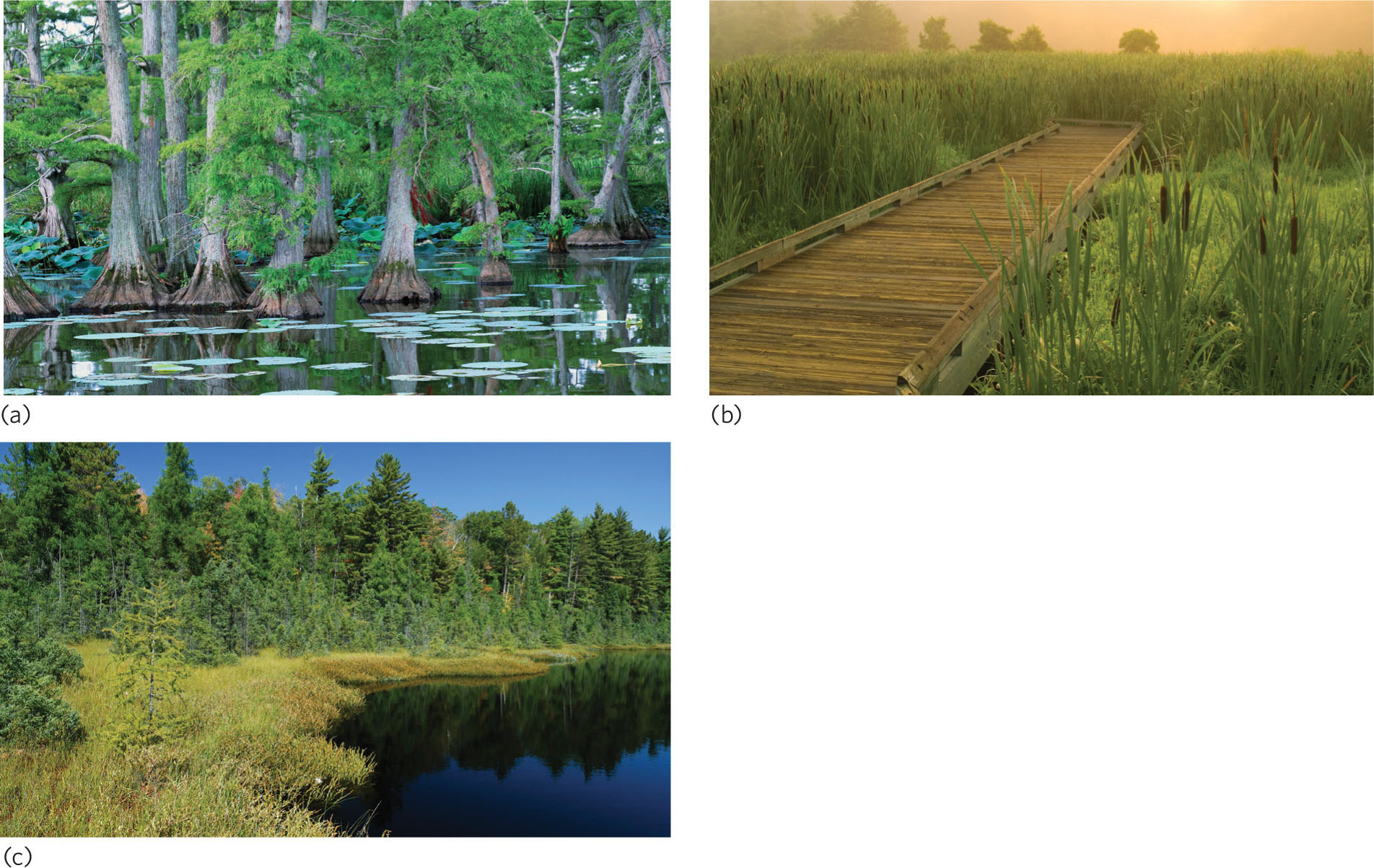
Freshwater Wetlands
Freshwater wetland An aquatic biome that contains standing fresh water, or soils saturated with fresh water for at least part of the year, and which is shallow enough to have emergent vegetation throughout all depths.
Freshwater wetlands are aquatic biomes that contain standing fresh water, or soils saturated with fresh water for at least part of the year, and are shallow enough to have emergent vegetation throughout all depths. Most of the plants that grow in wetlands can tolerate low oxygen concentrations in the soil; many are specialized for these anoxic conditions and grow nowhere else.
Freshwater wetlands include swamps, marshes, and bogs (Figure 6.17). Swamps contain emergent trees. Some of the best-known swamps are the Okefenokee Swamp in Georgia and Florida and the Great Dismal Swamp in Virginia and North Carolina. Marshes contain emergent nonwoody vegetation such as cattails. Some of the largest marshes in the world include the Everglades in Florida and the Pantanal of Brazil, Bolivia, and Paraguay. In contrast to swamps and marshes, bogs are characterized by acidic waters and contain a variety of plants including sphagnum mosses and stunted trees that are specially adapted to these conditions. Some of the largest bogs are found in Canada, northern Europe, and Russia.
153
Freshwater wetlands provide important habitat for a wide variety of animals, notably waterfowl and the larval stages of many species of fish and invertebrates that are characteristic of open waters. Wetland sediments immobilize potentially toxic or polluting substances dissolved in water and therefore function as a water purification system.
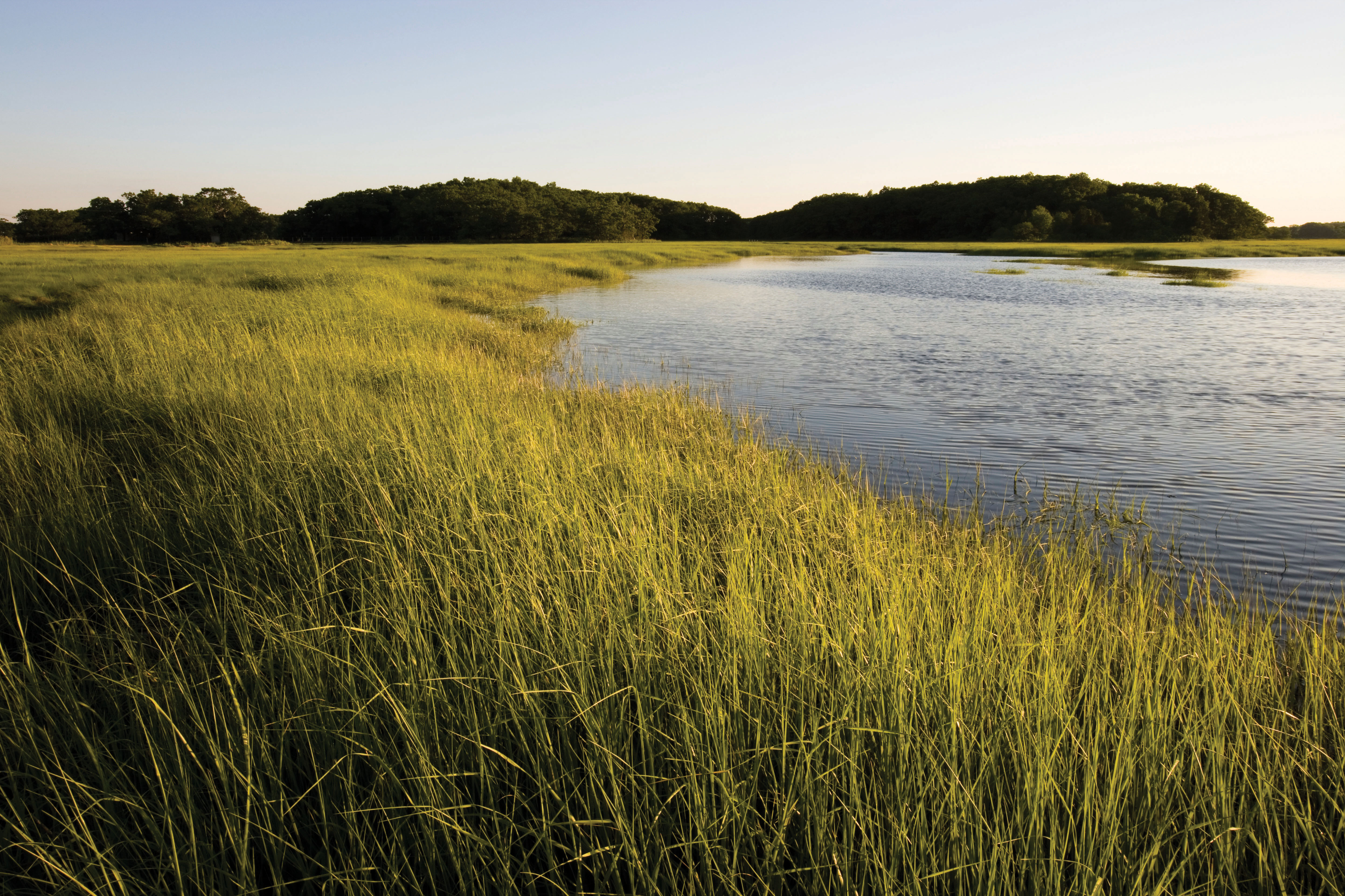
Salt Marshes/Estuaries
Salt marsh A saltwater biome that contains nonwoody emergent vegetation.
Salt marshes are a saltwater biome that contains nonwoody emergent vegetation. Salt marshes are found along the coasts of continents in temperate climates, often within estuaries that occur where the mouths of rivers mix with the salt water from oceans (Figure 6.18). Estuaries are unique because of their mix of fresh and salt water. In addition they contain an abundant supply of nutrients and sediments carried downstream by rivers. The rapid exchange of nutrients between the sediments and the surface in the shallow waters of an estuary supports extremely high biological productivity. Because estuaries tend to be areas of sediment deposition, they are often edged by extensive tidal marshes at temperate latitudes and by mangrove wetlands in the tropics. With a combination of high nutrient levels and freedom from water stress, tidal marshes are among the most productive habitats on earth. They contribute organic matter to estuarine ecosystems, which in turn support large populations of oysters, crabs, fish, and the animals that feed on them.
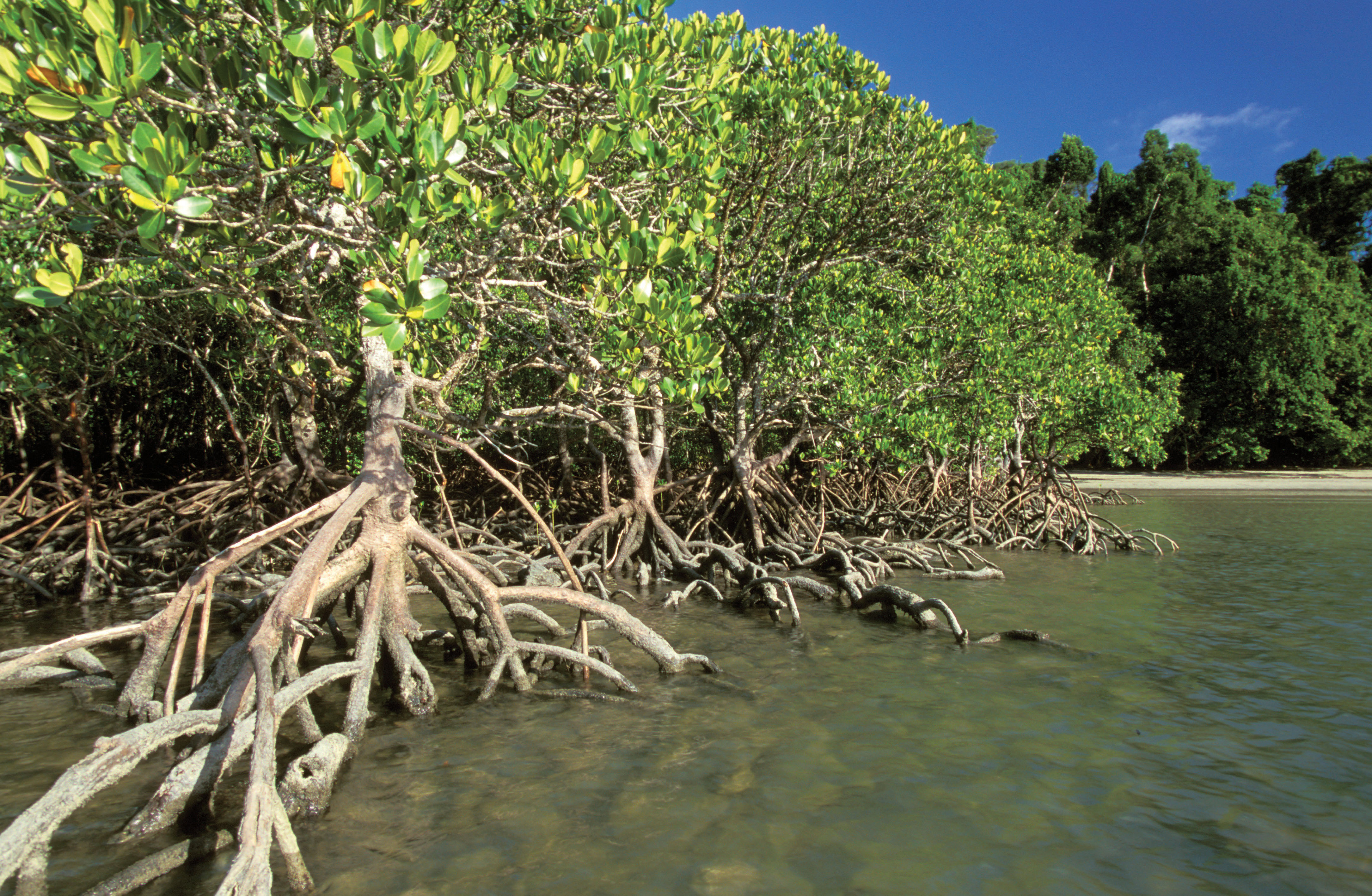
Mangrove Swamps
Mangrove swamp A biome that occurs along tropical and subtropical coasts, and contains salt-tolerant trees with roots submerged in water.
Mangrove swamps are a biome that exists in salt water along tropical and subtropical coasts and contains salt-tolerant trees with roots submerged in water. This biome can also occur in estuaries where fresh water and salt water mix (Figure 6.19). Salt tolerance is a key adaptation of trees that live in mangrove swamps. By living along the coasts, these trees play important roles in preventing the erosion of coastal shorelines from constant incoming waves. The swamps also provide critical habitat to many species of fish and shellfish.
154
Intertidal Zones
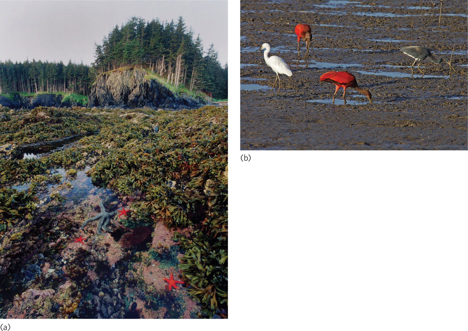
Intertidal zone A biome consisting of the narrow band of coastline between the levels of high tide and low tide.
The intertidal zone is a biome consisting of the narrow band of coastline between the levels of high tide and low tide. As the tides come in and go out, the intertidal zone experiences widely fluctuating temperatures and salt concentrations. The species living in this biome—including crabs, barnacles, sponges, mussels, and algae—must therefore possess adaptations that allow them to tolerate such harsh conditions. Intertidal zones can occur along steep rocky coastlines, as one might find in Maine, or gently sloping mudflats, as one might find in Cape Cod Bay in Massachusetts (Figure 6.20).
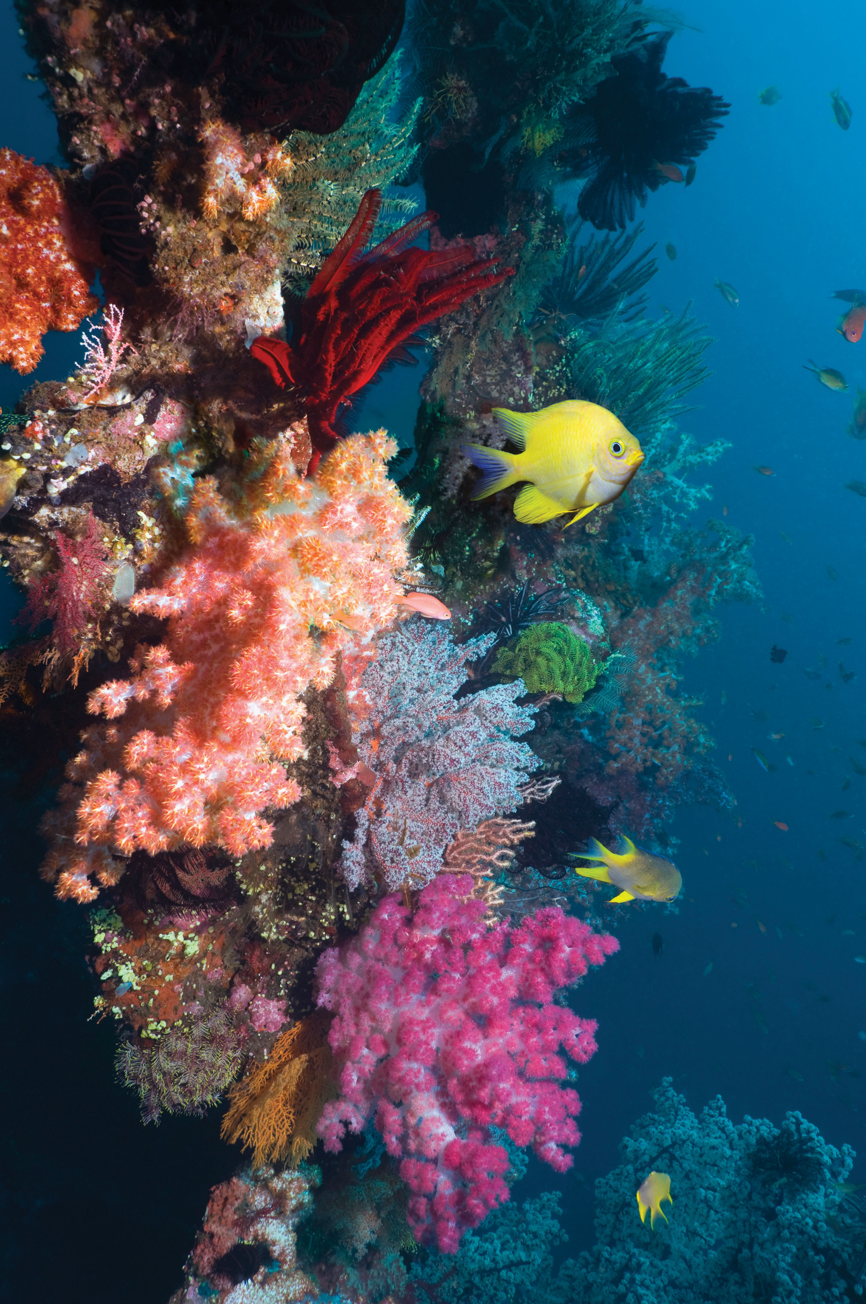
Coral Reefs
Coral reef A marine biome found in warm, shallow waters that remain 20°C year-round.
Coral reefs are a marine biome found in warm, shallow waters that remain above 20°C year-round. Coral reefs often surround volcanic islands, where they are fed by nutrients eroding from the rich volcanic soil and by deep-water currents forced upward by the profile of the island.
Corals are tiny animals—related to hydra and other cnidarians—that live in a mutualistic relationship with algae. An individual coral is a hollow tube that secretes a hard exoskeleton made of calcium carbonate. It also has tentacles that sweep detritus and plankton into the tube. As it digests these particles, the coral produces CO2 that can be used by their symbiotic algae in photosynthesis. Some of the sugars and other organic compounds the algae produce leak into the coral tissues and further support coral growth. Although an individual coral is tiny, corals live in huge colonies. As an individual coral dies, the soft tissues decompose but the hard outer skeletons remain behind. Over time, these skeletons accumulate to form massive coral reefs.
The complex structure that corals build provides a wide variety of substrates and hiding places for algae and animals. This helps to make coral reefs among the most diverse biomes on Earth (Figure 6.21). As you may recall from our discussion of coral reefs in Chapter 2, rising sea surface temperatures in the tropics are causing the departure of the algal symbionts of corals over large areas—a phenomenon known as coral bleaching. Because the algal symbionts are critical to the survival of the coral, the stability of these biomes is now at risk.
The Open Ocean
The open ocean is characterized as the part of the ocean that is away from the shoreline and coral reefs. Open oceans cover the largest portion of the surface of Earth. Beneath the surface lies an immensely complex realm with large variations in temperature, salinity, light, pressure, and currents. Ecologists recognize a number of zones in the open ocean, shown in Figure 6.22. Beyond the range of the lowest tidal level, the neritic zone extends to depths of about 200 m, which correspond to the edge of the continental shelf. Because strong waves move nutrients to the sunlit surface layers from sediments below, the neritic zone is generally a region of high productivity. Beyond the neritic zone, the seafloor drops rapidly to the great depths of the oceanic zone. Here, nutrients are sparse, and production is strictly limited. Finally, the benthic zone consists of the seafloor underlying the neritic and oceanic zones.
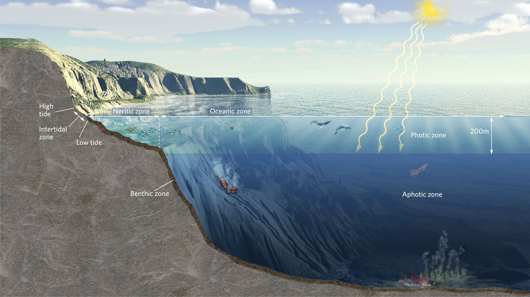
Neritic zone The ocean zone beyond the range of the lowest tidal level, and which extends to depths of about 200 m.
Oceanic zone The ocean zone beyond the neritic zone.
155
156
Photic zone The area of the neritic and oceanic zones that contains sufficient light for photosynthesis by algae.
The neritic and the oceanic zones may be subdivided vertically into a photic zone and an aphotic zone. The photic zone is the area of the neritic and oceanic zones that contains sufficient light for photosynthesis by algae. The aphotic zone is the area of the neritic and oceanic zones where the water is so deep that sunlight cannot penetrate. However, as we saw in Chapter 1, bacteria in the aphotic zone use chemosynthesis to convert inorganic carbon into simple sugars. Other organisms in the aphotic zone depend on the organic material that falls from the photic zone. One of the fascinating adaptations of many organisms in the aphotic zone is the ability to generate their own source of light, known as bioluminescence, to help them find and consume prey. A number of jellyfish, crustaceans, squid, and fish species have independently evolved this ability.
Aphotic zone The area of the neritic and oceanic zones where the water is so deep that sunlight cannot penetrate.
In this chapter, we have explored how differences in climate around the world determine the types of dominant plant forms that can persist in different parts of the world, forming the basis of categorizing terrestrial biomes. In contrast, the aquatic biomes are categorized by differences in water flow, depth, and salinity. In all cases, there is a close association between the environmental conditions and the species that have evolved adaptations to live under these conditions. Of course, adaptations reflect not only the physical factors in the environment but also the many interactions with other organisms. In the next chapter, we examine the process of evolutionary adaptation and see how it has created the tremendous diversity of life on Earth.
ECOLOGY TODAY CONNECTING THE CONCEPTS
CHANGING BIOME BOUNDARIES

Throughout this chapter we have seen that climate largely determines the location of the terrestrial biomes. Climatic conditions, combined with species interactions, set the edges of biome boundaries. Given our understanding of how biome boundaries form, what would happen to the biomes, and the species living in them, if the climate changed?
157
Records show us that during the past 130 years, temperatures of the surface of Earth have increased an average of 1°C. In fact, nine of the warmest years ever recorded happened during the 11-year period from 2001 to 2011. This small average increase in Earth’s temperature conceals the fact that some regions have become 1°C to 2°C cooler during this time while others have become up to 4°C warmer. Scientists predict even greater increases in temperature and large changes in precipitation patterns for the twenty-first century. If climate determines the location of biomes and the climate is changing, it seems reasonable to predict that the boundaries of biomes are also going to change.
In some cases, scientists believe that shifting biome boundaries might occur relatively easily. Where no barriers prevent movement, plant and animal populations will be able to shift north or south over several decades without much difficulty. However, when movement is blocked, for example by mountain ranges or large highways, the plants and animals may not be able to survive the changing conditions. Consider the woodland/shrubland biome on the southwestern coast of Australia. This small biome is located on a relatively small area of coastal land, with an ocean to the south and west, and a desert to the north and east. Scientists predict that this biome will become hotter and drier during the current century. If this prediction is correct, organisms that cannot tolerate the increase in temperature will have nowhere hospitable to go since the neighboring desert biome is already too dry for them to survive. Scientists who examined one group of plants from the genus Banksia, which is composed of 100 species, concluded that over the next 70 years, 66 percent of these species will decline in abundance and 25 percent will go extinct.
Climate changes also affect human agriculture. Recall from the beginning of this chapter that most of the world’s wine is produced in the shrubland/woodland biome. However, changes in climate have already affected the cultivation of grapes used in winemaking. In France, for example, over the past 30 years warmer growing seasons have caused grapes to ripen 16 days earlier than previously. This warmer climate alters the sugar content and acidity of the grapes—two components that must be in balance to make a fine-tasting wine. This problem is so serious for winemakers and wine consumers that in 2009 French wine growers called upon world leaders to take immediate action to try to reverse global climate change. On the other hand, locations at slightly higher latitudes that had temperatures that were historically too cool for growing quality wine grapes are now reporting increased summer temperatures that have allowed them to produce some of the best wine grapes in years. This is a good development for winemakers in countries such as England, but devastating for the French who have a long history of making some of the world’s finest wines.
SOURCES: Fitzpatrick, M. C., A. D. Grove, N. J. Sanders, and R. R. Dunn. 2008. Climate change, plant migration, and range collapse in a global biodiversity hotspot: TheBanksia (Proteaceae) of Western Australia. Global Change Biology 14: 1337–1352.
Iverson, J. T. How global warming could change the winemaking map. 2009. Time Magazine, December 3.
158