SCIENCE LITERACY WORKING WITH DATA
The Mississippi River lies on three sides of the city of New Orleans, curving around it. To the fourth side of the city lies Lake Pontchartrain, 65 kilometers (40 miles) long and over 50 kilometers (30 miles) wide; the lake connects directly with the Gulf of Mexico. Until 140 years ago, much of southern Louisiana was swampland, lower than sea level and much lower than the level of the Mississippi River. As the swamps were drained, levees were built, beginning in the 1700s, speeding up after 1880, and continuing today.
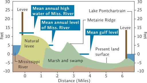
Interpretation
1. What is the difference in mean annual water level, in feet, between Lake Pontchartrain and the Mississippi River at New Orleans? Why is this?
The Mississippi River mean annual water level is about 5 feet above sea level. The Lake Pontchartrain average level is 0, or sea level, because it is directly connected to the ocean. Therefore the difference is about 5 feet.
2. New Orleans lies between the levees that hold back the Mississippi River and Lake Pontchartrain. What are the highest and lowest elevations of the city itself, in feet?
The highest elevation of the city is 7 feet above sea level (Metaurie Ridge), and the lowest area is about 5 feet below sea level (-5 feet). Without the levees in place that area would be underwater.
3. What type of former ecosystem lies underneath most of the city?
Marsh and swampland lies beneath most of the city.
Advance Your Thinking
4. Without the levees throughout the southern half of the state, what would happen?
Much of the area would be underwater, and would return to the marshes and swamps that used to be there. This would protect areas farther inland from serious storms and hurricanes, cleanse the Mississippi River water of many of the nutrients it currently carries out into the Gulf of Mexico, and also remove many of the industrial chemicals, medicines, and other compounds that currently end up in the Gulf.
5. Why do southern Louisiana cemeteries feature above-ground tombs, crypts, and vaults rather than graves?
You cannot bury someone underground because the grave will fill with water. Most of the southern half of the state is at an elevation lower than, or equal to, the water table.
6. In 2005, Hurricane Katrina devastated New Orleans and much of southern Louisiana. In its aftermath, researchers studied the area, trying to understand what happened. What steps could Louisiana take to avoid a repeat of this flooding and damage in the future?
New Orleans could stop draining and removing the swamplands — they provide protection from high waters — and stop building in the lowest areas of the city, instead building better, higher levees. Some of the natural wetlands could be restored to help blunt the impact of storm surge (both by slowing its movement inland and better absorbing some of the water).