SCIENCE LITERACY WORKING WITH DATA
The data in the following table comes from a research document prepared by the Temperate Grasslands Conservation Initiative of the IUCN World Commission on Protected Areas. The document was prepared to build a case for the conservation and protection of temperate grassland ecosystems by evaluating their total economic value to human well-being.
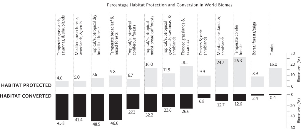
Interpretation
1. What does this figure show? Which of the grassland ecosystems is the most converted? Which one is the most protected?
The figure shows a comparison between habitat conversion and habitat protection for 13 global biomes. Of the 4 grassland biomes represented, temperate grasslands, savannas, and shrublands are the most converted, with 45.8% of the habitat converted; while montane grasslands and shrublands are the most protected, with 24.7% of the habitat protected.
2. The Conservation Risk Index (CRI) is a ratio of habitat converted to habitat protected for each biome. It is used to assess the level of threat to a particular biome.
Calculate the CRI for each of the 13 biomes. Here is one example: CRI of deserts and xeric shrublands is 6.8 / 9.9 = 0.7.
A CRI greater than 8 suggests a critically endangered biome (in other words 8 times as much land is being converted as is being protected). A CRI of 2 or less is considered a biome with a low risk of endangerment. According to the CRIs you calculated in part a, what is the status of each of the grasslands?
a. CRI calculations:
Temperate grasslands, savannas, and shrublands: 10
Mediterranean forests, woodlands, and scrub: 8.2
Tropical/subtropical dry broadleaf forests: 6.4
Temperate broadleaf and mixed forests: 4.7
Tropical/subtropical dry coniferous forests: 4.1
Tropical/subtropical moist broadleaf forests: 2.0
Tropical/subtropical grasslands, savannas, and shrublands: 2.0
Flooded grasslands and savannas: 1.5
Deserts and xeric shrublands: 0.7
Montane grasslands and shrublands: 0.5
Temperate conifer forests: 0.5
Boreal forests/taiga: 0.3
Tundra: 0.0
b. Temperate grasslands, savannas, and shrublands are the most endangered grasslands. In fact, with a CRI of 10, they are the most critically endangered of the 13 biomes. All the other grasslands are not endangered, as they have a CRI of 2 or less—the CRI for tropical/subtropical grasslands, savannas, and shrublands is 2; the CRI for flooded grasslands and savannas is 1.5; and montane grasslands and shrublands have a CRI of 0.5.
Advance Your Thinking
3. What patterns do you see in the CRIs you calculated above? Describe two patterns and include data to support your explanation.
Two patterns that can be seen:
• Generally, temperate biomes are more at risk than tropical biomes: Only one temperate biome (temperate conifer forests) of the four has a CRI of less than 2. The biomes of high latitudes and high altitudes (such as tundra, boreal forests, and montane grasslands) are the most intact.
• Biomes of intermediate levels of conversion, such as montane grasslands and temperate conifer forests with a conversion level of about 13%, have the highest level of protected habitat (about 25% in each case). By contrast, biomes with very high and very low levels of conversion have little habitat protection. For example, temperate grasslands, tropical/subtropical dry broadleaf forests, and temperate broadleaf forests—which are the most converted, at more than 45% in each case—are the least protected, each at less than 10%. Similarly, the least disturbed habitats, such as tundra and boreal forests (with conversion rates of less than 3%), also have low protection, at less than 16% in each case.
4. Which ecoregions are under the greatest threat?
Temperate and tropical ecoregions face the greatest conversion, with small- to moderate-sized areas under protection. This is likely due to their location (in areas where people live) and to their productivity (rich soils of temperate grasslands and forests are good for agriculture). The least threatened temperate biome contains conifer forests, areas that may be drier than other temperate areas and so not as suited for agriculture.