11
Images from Space
355
Satellite Remote Sensing, Satellite Orbits,
Sensor Resolutions, the Landsat Program, and
High-Resolution Satellite Sensors
How many times have you seen something like this in a movie? The heroes are racing against the clock to stop the villains from setting off whatever doomsday weapon they happen to have. In the tense mission-control center, the heroes’ computer expert taps a few keys on the keyboard, a spy satellite swings into view, and suddenly the monitors fill up with crystal-clear images from space of the villains’ remote hideout. The imagery’s crisp enough for the heroes to run some facial recognition software and pick out the international arms dealer selling the weapons of mass destruction (WMDs), as well as read the license plates of the nearby cars. Rest assured, the members of the elite counterintelligence strike team will show up on cue to save the world, probably watched via live remotely sensed satellite video feed by their teammates at the home base.
From this kind of scenario, you might get the impression that remote sensing satellites are magical things that can do anything—rotate into whatever orbital position is required to track people, zoom in (from outer space) to make out the details of someone’s license plate, read lips from space, or send live video feeds to the good guys in the field. Certainly, best-selling books and blockbuster movies can help to perpetuate the idea that remote sensing (and anything involving satellites) is some sort of utopian technology that can do anything. The goal of this chapter is to examine how satellite remote sensing really works and to have a look at what it can and can’t do in the real world.
NASA the National Aeronautics and Space Administration, established in 1958; it is the U.S. government’s space exploration and aerospace development branch
Corona a U.S. government remote sensing program, which utilized film-based camera equipment mounted in a satellite in Earth’s orbit; Corona was in operation from 1960 to 1972
The first man-made satellite to achieve orbit around Earth was Sputnik, launched in 1957 by the Union of Soviet Socialist Republics (USSR). It was quickly followed by the U.S. launch of Explorer I the next year. These initial satellite launches established that satellites carrying equipment (or, in the case of Sputnik II, animals) could be placed into orbit and that the equipment could then be put to use. As a result, NASA (the National Aeronautics and Space Administration) was established in 1958 to head up the U.S. space and aeronautics program. Satellites were first used for remote sensing reconnaissance and surveillance in 1960, when the Corona program was initiated.
356
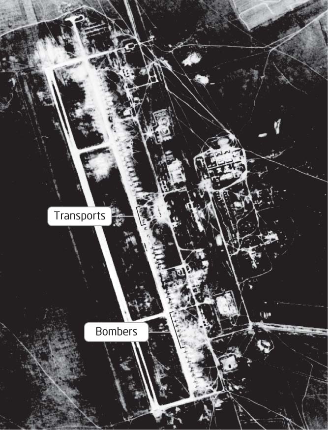
A Corona satellite had a camera onboard that took pictures of areas on the ground. When the roll of film was used up, it would be ejected from the satellite and collected by a U.S. plane. After the film was developed, it would then be interpreted by agents to provide intelligence information about locations around the world (see Figure 11.1 for an example of Corona imagery). Corona and its counterpart—the USSR’s Zenit satellite—provided numerous images from orbit, with Corona itself providing an estimated 800,000 remotely sensed satellite images. Corona ceased operation in 1972, and its imagery was declassified in 1995. Satellite remote sensing has continued, however, and a series of satellites is now used by the U.S. government for acquiring digital imagery of areas around the world.
Beyond government surveillance, satellites are used today for a wide variety of purposes, constantly collecting data and imagery of the world below. How does satellite imaging compare with the aerial photography we discussed in Chapter 9? Using a satellite instead of an aircraft has several apparent advantages. Satellites are constantly orbiting Earth and taking images—there’s no need to wait for a plane to fly over a particular area of interest. Satellites can image a much larger area than a single aerial photograph can. Also, remote sensing satellites provide global coverage and are not restricted to geographic boundaries or constraints the way aircraft are, since satellites orbit hundreds of miles above Earth’s surface.
357