11.4 
What Satellites Have High-Resolution Sensors?
SPOT a high-resolution imagery satellite program operated by Astrium Services
There are several remote sensing satellites with high-resolution capabilities. This section describes a few of the more prominent ones. The SPOT (Satellite Pour l’Observation de la Terre) program is owned and operated by Astrium Services. The SPOT series of satellites was initiated by CNES, the French space agency, and developed by Swedish and Belgian space agencies. The first satellite (SPOT 1) was launched in 1986. Imagery from SPOT 5 (launched in 2002) has been in use for over a decade. SPOT 5 has a revisit cycle of 26 days but has off-nadir viewing capabilities that significantly improve some of its sensors’ temporal resolution. The highest spatial resolution of a SPOT 5 image is 2.5 meters, allowing a significant amount of detail to be determined from a single image.
373
SPOT 5 carries three sensors:
 Vegetation-2: A sensor with a 1-kilometer spatial resolution, used for broad-scale environmental monitoring.
- HRS (High Resolution Stereoscopic) sensor: A sensor with 10-meter resolution, used for the development of stereo imagery (see Chapter 14) and digital elevation models (see Chapter 13).
- HRG (High Resolution Geometric) sensors: A pair of sensors with multiple resolutions available—20-meter (an infrared band), 10-meter (multispectral sensor with green, red, near-infrared, and one other infrared band), 5-meter (panchromatic), and a 2.5-meter panchromatic Supermode.
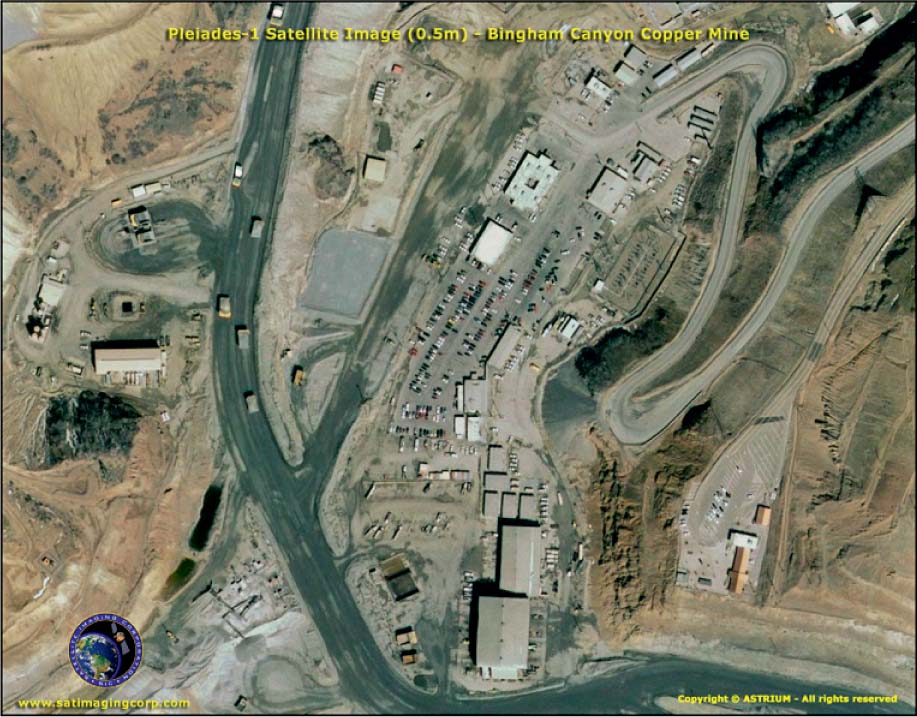
Pléiades a series of satellites developed by Astrium Services, the first of which was launched in 2011 and featured sensors with a multispectral spatial resolution of 2 meters and panchromatic resolution of 0.50 meters
Astrium Services, a private company, has developed SPOT 6 (launched in 2012) and SPOT 7 (scheduled to be launched in 2014). SPOT 6 features improved resolution capabilities (including a 1.5-meter panchromatic spatial resolution and 6-meter resolution for four multispectral bands) as well as the stereo capability for production of digital elevation models. SPOT 6 and 7 ensure a continuity of SPOT imagery for when SPOT 5 is eventually shut down. A related Astrium program is the Pléiades constellation, a series of satellites (currently consisting of Pleiades-1A and Pleiades-1B), the first of which launched in 2011. Pléiades-1A features very high-resolution panchromatic (0.5-meter spatial resolution) and multispectral (2-meter spatial resolution of four bands, which can then be pan-sharpened to 0.5-meters) capabilities (see Figure 11.13 for an example of Pléiades-1A’s high-resolution imagery).
374
Much of the available high-resolution satellite imagery is distributed and sold by private companies from the satellites that they own and operate. For instance, the high-resolution satellite imagery seen in some images on Google Earth comes from a commercial provider. One thing to keep in mind is that current U.S. government regulations do not permit the sale of imagery of less than 0.5 meter resolution to commercial customers (so imagery of finer resolution is resampled to this level before it is distributed). Two key satellite imagery companies (GeoEye and DigitalGlobe) combined in January 2013 to become one single company (now just called DigitalGlobe). The following high-resolution satellites are all under the umbrella of this merged company.
IKONOS a satellite launched in 1999, which features sensors with a multispectral spatial resolution of 3.2 meters and panchromatic resolution of 0.8 meters
The IKONOS satellite was launched in 1999, and its imagery was one of the benchmarks of commercial high-resolution imagery. IKONOS has two sensors, a four-band (blue, green, red, and near-infrared) multispectral sensor that has 3.2-meter spatial resolution and a panchromatic sensor with 0.8-meter spatial resolution. Both sensors have very high radiometric resolution (11 bits) and, with off-nadir viewing capabilities, can achieve a temporal resolution of about 3 days. Panchromatic or pan-sharpened IKONOS imagery provides very crisp and detailed image resolution—details of urban environments can be distinguished with little difficulty, although details of objects that are smaller than its resolution cannot be detected (see Figure 11.14 for an example of IKONOS imagery that demonstrates the kind of spatial resolution this sensor can provide).
375
QuickBird a satellite, launched in 2001 by DigitalGlobe, whose sensors have 2.4-meter multispectral resolution and 0.61-meter panchromatic resolution
WorldView-1 a satellite, launched in 2007 by DigitalGlobe, whose panchromatic sensor has 0.5-meter spatial resolution
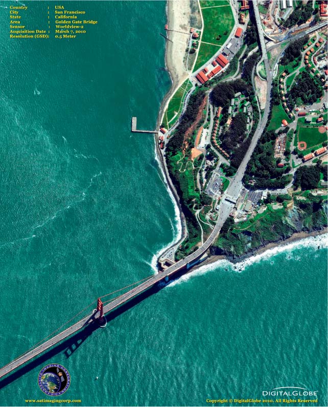
WorldView-2 a satellite, launched in 2009 by DigitalGlobe, which features an 8-band multispectral sensor with 1.84-meter resolution and a panchromatic sensor of 0.46-meter resolution
WorldView-3 a DigitalGlobe satellite project that is scheduled to be launched in 2014. It is expected to feature multispectral, shortwave infrared and CAVIS bands, plus a panchromatic sensor of 0.31-meter resolution.
In 2001, DigitalGlobe launched its QuickBird satellite, whose sensors provided higher spatial resolution than IKONOS. Like IKONOS, QuickBird featured two sensors—a four-band (blue, green, red, and near-infrared) multispectral sensor with 2.4-meter spatial resolution as well as a panchromatic sensor with 0.61-meter spatial resolution. Both sensors feature very fine 11-bit radiometric resolution and, with off-nadir viewing capability, have a temporal resolution between 1 and 3.5 days. Obviously, 61-centimeter imagery provides extremely high-resolution capabilities, allowing very crisp details to be observed in an image.
In 2007, DigitalGlobe launched WorldView-1, which featured an improved panchromatic sensor with 0.5-meter spatial resolution. In October 2009, DigitalGlobe launched WorldView-2 with 0.46-meter panchromatic and 1.84-meter 8-band multispectral spatial resolution. WorldView-3 is scheduled to launch in 2014, and it is expected to provide 0.31-meter panchromatic and 1.24-meter 8-band multispectral resolution, plus 8 more shortwave infrared bands and an additional 12 bands for monitoring clouds, aerosols, and water. See Figure 11.15 for an example of the high-resolution imagery acquired by the WorldView-2 satellite.
GeoEye-1 a satellite launched in 2008, which features a panchromatic sensor with a spatial resolution of 0.41 meters
GeoEye-2 a satellite planned for a future launch, which is expected to feature a panchromatic sensor with a spatial resolution of 0.34 meters
The highest spatial resolution imagery currently commercially available is from the sensors onboard the GeoEye-1 satellite, launched in 2008 by GeoEye. GeoEye-1 has two sensors—a four-band multispectral (blue, green, red, and near infrared) sensor with 1.65-meter spatial resolution and also a panchromatic sensor with 0.41-meter spatial resolution. This spatial resolution represents the finest commercial resolution on the market today, currently making GeoEye-1 the satellite with the sensors to beat when it comes to high-resolution imagery. A second satellite, GeoEye-2, currently readied for future launch will feature both a multispectral sensor with an improved spatial resolution of 1.36 meters and also a panchromatic sensor with an improved spatial resolution of 0.34 meters. See Hands-on Application 11.6: Viewing High-Resolution Satellite Imagery for examples of all of these high-resolution images online.
376
 HANDS-ON APPLICATION 11.6
Viewing High-Resolution Satellite Imagery
While the data acquired by satellites like IKONOS and QuickBird is sold commercially, you can view samples of these satellite images at several places online. The Satellite Imaging Corporation’s Website provides a means for viewing high-resolution imagery. Open your Web browser and go to http://www.satimagingcorp.com. Select the option for Gallery, and then select High-Resolution Sensors. Available imagery includes GeoEye-1, IKONOS, Pléiades-1A, Pléiades-1B, QuickBird, SPOT 5, SPOT 6, WorldView-1, and WorldView-2. Examine some examples of every sensor, keeping in mind the specifications of each. You can zoom in on the sample imagery from each satellite to get a real sense of what can be seen via high-spatial resolution satellites. Note that the images available on the Website are just crisp graphics, not the actual satellite data itself.
Expansion Questions:
-
Question
From viewing the gallery examples of high-resolution imagery, what kinds of analysis or interpretation are these images being used for?
-
Question
What current events have samples of high-resolution images available for viewing through the Website (and which satellite sensors were they acquired by)?