12.2 
What Is Aqua and What Does It Do?
Aqua a key EOS satellite whose mission is to monitor Earth’s water cycle
Launched in 2002 as a joint mission between NASA and agencies in Brazil and Japan, Aqua is another key EOS satellite. In Latin, “Aqua” means “water,” indicating the main purpose of the satellite: to examine multiple facets of Earth’s water cycle. Analysis of water in all its forms—solid, liquid, and gaseous—is the key element of all six instruments onboard Aqua. Terra and Aqua are designed to work in concert with one another—their Sun-synchronous orbits are set up similarly so that while Terra is on a descending path, Aqua is ascending (and vice versa). Because of this setup, Terra crosses the Equator in the morning while Aqua crosses in the afternoon (Aqua was originally called EOS-PM to complement Terra’s original EOS-AM-1 name). This connection is further strengthened as both satellites carry a MODIS and a CERES instrument, in essence doubling the data collection performed by these two tools.
AMSU-A the Advanced Microwave Sounding Unit instrument onboard Aqua
HSB the Humidity Sounder for Brazil instrument onboard Aqua
AIRS the Advanced Infrared Sounder instrument onboard Aqua (used in conjunction with Aqua’s HSB and AMSU-A instruments)
Beyond duplicate MODIS and CERES instruments, Aqua carries four others that are unique to its mission of examining Earth’s water cycle: AMSU-A, HSB, AIRS, and AMSR-E. The AMSU-A (Advanced Microwave Sounding Unit) instrument is used to create profiles of the temperature in the atmosphere. AMSU-A uses 15 microwave bands and is referred to as a “sounder” because its instruments are examining a three-dimensional atmosphere, similar to the way “soundings” were used by ships to determine water depths. AMSU-A’s data provides estimates not only of temperature data but also of precipitation and atmospheric water vapor. Similarly, the four microwave bands of the HSB (Humidity Sounder for Brazil) measured atmospheric water vapor levels (in other words, humidity) in the atmosphere until the instrument stopped operating in 2003. Aqua’s fifth instrument is AIRS (Advanced Infrared Sounder), whose uses include measuring temperatures and humidity levels in the atmosphere as well as information about clouds.
AMSU-A and HSB data are used in close conjunction with AIRS to create a combined sounding system for Aqua. Data products derived from this suite of instruments include three-dimensional maps of atmospheric temperature, cloud types, ozone profiles, carbon dioxide levels, and sea surface temperature. This kind of information can be used to improve weather forecasting as well as to study Earth’s atmosphere and climatic systems.
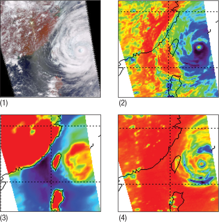
Figure 12.8 shows an example of these three instruments (sometimes referred to as the “AIRS Suite”) working together for one purpose—in this instance, tracking and monitoring a tropical cyclone. The four images show (1) the visible portion of the spectrum, sensed by AIRS, showing the extent and dimensions of tropical cyclone Ramasun in 2002, (2) a temperature profile of the cyclone sensed by AIRS, (3) imagery of the surface below the clouds as sensed by AMSU-A, which can see through the cloud cover of the cyclone, and (4) the level of precipitation produced by the cyclone as sensed by HSB. All of the AIRS Suite instruments provide different “snapshots” of the same feature, allowing a wealth of data to be collected about different kinds of weather phenomena.
395
AMSR-E the Advanced Microwave Scanning Radiometer for EOS instrument onboard Aqua
AMSR-E (the Advanced Microwave Scanning Radiometer for EOS) is the last of the Aqua instruments. It uses 12 microwave bands to cover most of the planet in one day and completes a global dataset in the second day. Unfortunately, due to mechanical issues, AMSR-E stopped producing imagery in October 2011. AMSR-E monitored a variety of environmental factors that affect global climate conditions, including sea ice levels, water vapor, wind speed, and amounts of global rainfall. For example, by assessing the amount of rain across the planet on a near-daily basis, AMSR-E could provide measures of how much precipitation storms can produce as they move across land or oceans.
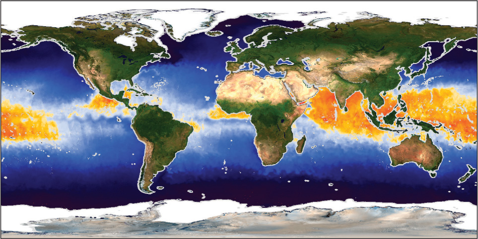
AMSR-E was also used to measure sea surface temperature (from a millimeter of water on the surface of the ocean) across the globe. As NASA notes, regular sea surface temperatures can be used in hurricane forecasting and also to track tropical storms. A hurricane requires warm water in the oceans to power up and sustain itself (the water has to be 82°F or higher for a hurricane to form). With regular temperature measurements, conditions for potential hurricanes can be quickly assessed. See Figure 12.9 for an example of AMSR-E sea surface temperature imagery—those places with ocean temperatures of 82°F or more are shown in yellow and orange. By knowing where the conditions are right, scientists can forecast the potential for hurricane development. See Hands-on Application 12.3: Aqua Products and the Visible Earth for more about AMSR-E and the other Aqua instruments.
396
 HANDS-ON APPLICATION 12.3
Aqua Products and the Visible Earth
The Visible Earth is a content-rich online resource set up by NASA for examining applications of the EOS missions. If you wanted to view EOS imagery and information related to water quality, a variety of applications from numerous sensors (and not just limited to the three EOS satellites described in this chapter) is available to browse. Animated data showing changes over time and short video clips of simulations of satellite orbit or sensors are available as well. To examine some of the Aqua applications, open your Web browser and go to http://visibleearth.nasa.gov/view_cat.php?categoryID=1486.
Expansion Questions:

Question
What types of environmental features are Aqua’s instruments monitoring?
-
Question
How could a fully functioning AMSR-E be used to measure sea surface temperature in relation to hurricane locations? See here for further application: http://visibleearth.nasa.gov/view.php?id=8952.
-
Question
How can the AIRS Suite be used to study tropical storms and hurricanes? See here for further application: http://visibleearth.nasa.gov/view.php?id=13777.
-
Question
How could a fully functioning AMSR-E be used to measure the extent of sea ice? See here for further application: http://visibleearth.nasa.gov/view.php?id=2752.