1.2 
Who Uses Geospatial Technology?
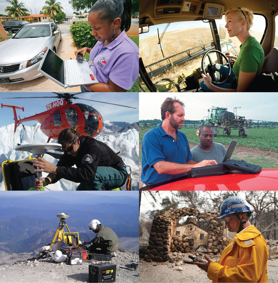
Geospatial technology is used in a wide variety of fields (Figure 1.1), including federal, state, and local government, forestry, law enforcement, public health, biology, and environmental studies (see Hands-on Application 1.1: Industries Using Geospatial Technology for a look at industries employing people in these fields). As long as the job field involves the utilization of some sort of information or data that has a location associated with it, chances are that some sort of geospatial technology is being used. Geospatial technology has been heralded by the U.S. Department of Labor as one of the main emerging and evolving job fields in the United States, with enormous growth potential. For instance, the Department of Labor’s O*NET utility contains job descriptions in fields such as “Geospatial Information Scientists and Technologists,” “Remote Sensing Scientists and Technologists,” and “Precision Agriculture Technicians” (see Hands-on Application 1.2: Jobs in the Geospatial Field for more information about types of jobs).
3
 HANDS-ON APPLICATION 1.1
Industries Using Geospatial Technology
Geospatial technology is being used in a variety of applications in numerous different fields today. For a deeper look at some of these applications, open your Web browser and go to http://www.esri.com/industries.html, which is part of the Esri company’s Website (we’ll discuss more about Esri in Chapter 5, but the short version is that they’re the market leader in GIS). This Website lists dozens of different fields that are using geospatial technology, and describes how GIS (and other Esri products) are being utilized in them. Examine a few of them that are connected to fields of interest of your own. For instance, if your interest is in law enforcement, examine some of the “Public Safety” applications. If you’re involved in public or community health, examine some of the “Health and Human Services” applications, then describe how GIS is being utilized in some real-world, on-the-job applications.
Expansion Questions:

Question
How is GIS being utilized in some real-world, on-the-job applications in fields of interest to you?
-
Question
Who in these fields is using GIS with what kinds of applications and why are they using GIS?
4
HANDS-ON APPLICATION 1.2
Jobs in the Geospatial Field
Businesses are hiring in the geospatial field. For examples of current job openings, open your Web browser and visit some of the following Websites:
- The GIS Jobs Clearinghouse: http://www.gjc.org
- GIS Jobs.com: http://www.gisjobs.com
- Geosearch: http://www.geosearch.com
- Geocommunity (GIS Jobs and Careers): http://careers.geocomm.com
- GIS Careers: http://giscareers.com
- GIS Lounge: http://jobs.gislounge.com
- GIS Connection: http://www.gisconnection.com
- Directions Magazine Geospatial and GIS Jobs: http://www.directionsmag.com/careers/geospatial-jobs
These are just a sampling of Websites where employers post job openings worldwide. Examine several jobs from areas near where you are (or where you’d like to go to).
Expansion Questions:
-
Question
What kinds of jobs are being advertised?
-
Question
What kinds of job qualifications, training, and skill sets are employers looking for?
-
Question
What kinds of starting salary ranges are employers offering?
The following are just a handful of examples of fields that utilize geospatial technology.
Archeology
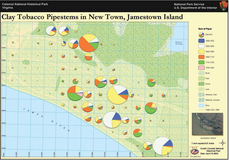
The ability to pinpoint the location of artifacts uncovered on a dig, construct a map of the area, and then search for patterns on the site are all archeological functions that can be rendered quickly and efficiently with geospatial technology (Figure 1.2). Archeologists can utilize historical maps, current aerial photography or satellite imagery, and location information obtained on the site throughout the course of their work.
City Planning
Utilities, wastewater, green space, traffic, roads, zoning, and housing are all matters of concern to urban planners. Geospatial technology provides a means of working with all of these entities together for planning purposes. Strategies for smart urban growth and the management and updating of city resources can be examined through a variety of different applications.
5
Environmental Monitoring
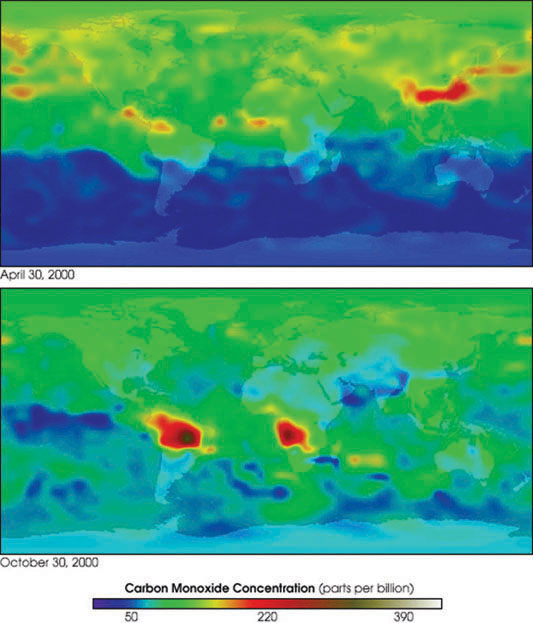
Processes that affect Earth’s environment in many different ways can be tracked and assessed using geospatial technology. Information about land-use change, pollution, air quality, water quality, and global temperature levels is vital to environmental research, ranging from the monitoring of harmful algae blooms to studies in climate change (see Figure 1.3).
6
Forestry
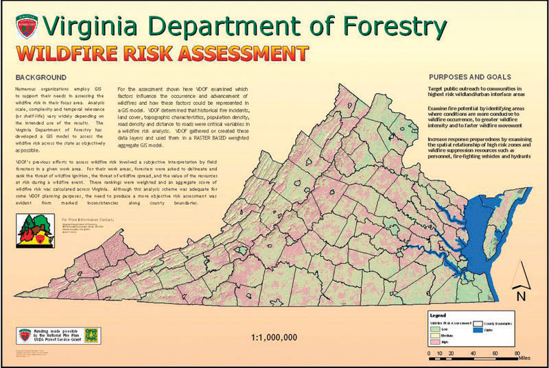
All manner of forest monitoring, management, and protection can be aided through the use of geospatial technology. Modeling animal habitats and the pressures placed upon them, examining the spatial dimensions of forest fragmentation, and managing fires are among the many different ways that geospatial technology is utilized within the field of forestry (Figure 1.4).
Homeland Security
Geospatial technology is a key component in examining vulnerable areas with regard to homeland security. Risk assessment of everything from evacuation plans to smoke-plume modeling can be examined using geospatial technology. Disaster mitigation and recovery efforts can be greatly enhanced through the use of current satellite imagery and location-based capabilities.
Law Enforcement
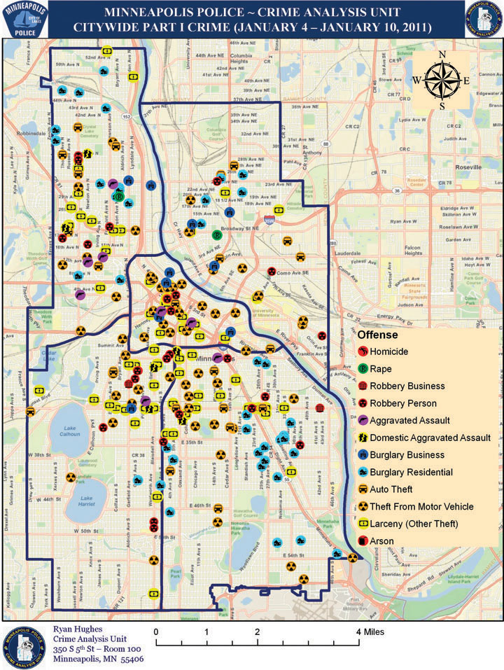
The locations of various types of crimes can be plotted using GIS. Law enforcement officials can use this information to analyze patterns (Figure 1.5) and to determine potential new crime areas. Geospatial technology can be used in several other ways beyond mapping and analysis; for instance, police departments can gather high-resolution aerial photography of locations of patrols to provide further information about potentially dangerous areas.
Health and Human Services
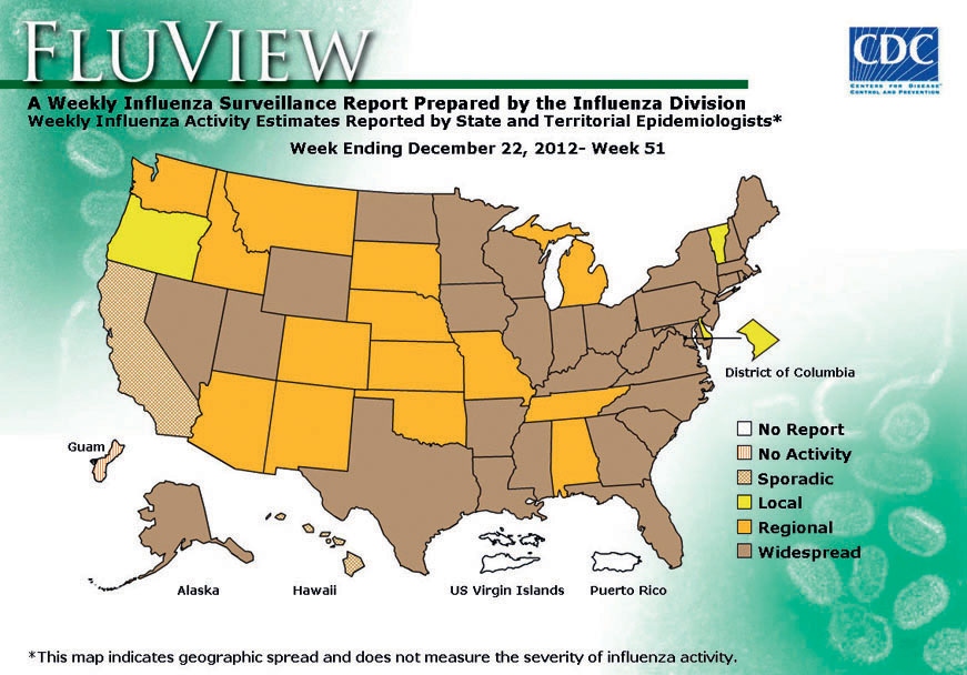
Geospatial technology is used in a variety of health-related services. For example, monitoring of diseases, tracking sources of diseases, and mapping health-related issues (such as the spread of H1N1 or other influenza; see Figure 1.6) are all tasks that can be completed using geospatial technology applications.
7
8
Military and Intelligence
Geospatial technology plays a key role in today’s military, defense, and intelligence worlds. Satellite imagery and aerial photography have long been used for intelligence gathering and reconnaissance, practices that continue today with an increased use of Unmanned Aerial Vehicles (UAVs) and high-resolution satellite sensors. The field of Geospatial Intelligence (GEOINT) encompasses all types of remotely sensed imagery, GIS, and GPS data for information gathering and analysis related to national security and defense applications.
Real Estate
Through geospatial technology, realtors and appraisers (as well as home buyers and sellers) can create and examine maps of neighborhoods and quickly compare housing prices and values of nearby or similar properties. Other features of a property can be examined by viewing high-resolution aerial images, showing the topography, the terrain, and even if it’s located on a floodplain. You can also examine where a property is located in relation to schools, highways, wastewater treatment plants, and other urban features.
geospatial data items that are tied to specific real-world locations
All of these areas and many, many more are reliant on the capabilities of geospatial technology. No matter the field, what distinguishes geospatial technology from other types of computer systems or technologies is that it explicitly handles geospatial data.