2.2 
What Is a Geographic Coordinate System?
geographic coordinate system (GCS) a set of global latitude and longitude measurements used as a reference system for finding locations
latitude imaginary lines on a globe north and south of the Equator that serve as a basis of measurement in GCS
Equator the line of latitude that runs around the center of Earth and serves as the 0 degree line to make latitude measurements from
longitude imaginary lines on a globe east and west of the Prime Meridian that serve as a basis of measurement in GCS
Prime Meridian the line of longitude that runs through Greenwich, England, and serves as the 0 degree line of longitude to base measurements on
degrees, minutes, and seconds (DMS) the measurement system used in GCS
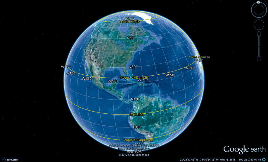
A geographic coordinate system (GCS) is a global reference system for determining the exact position of a point on Earth (see Figure 2.2 for an example of GCS). GCS consists of lines of latitude and longitude that cover the entire planet and are used to find a position. Lines of latitude (also referred to as parallels) run in an east-to-west direction around the globe. The Equator serves as the starting point of zero, with measurements north of the Equator being numbers read as north latitude and measurements south of the Equator being numbers read as south latitude. Lines of longitude (also called meridians) run north-to-south from the North Pole to the South Pole. The Prime Meridian (the line of longitude that runs through the Royal Observatory in Greenwich, England) serves as the starting point of zero. Measurements made east of the Prime Meridian are numbers read as east longitude, while measurements made west of the Prime Meridian are numbers read as west longitude. The breaking point between east and west longitude is the 180th meridian.
36
Using this system (where measurements are made north or south of the Equator and east or west of the Prime Meridian), any point on the globe can be located. GCS measurements are not made in feet or meters or miles, but in degrees, minutes, and seconds (DMS). A degree is a unit of measurement that can be broken into 60 subsections (each one referred to as a minute of distance). A minute can be subsequently broken down into 60 subsections (each one referred to as a second of distance). A single minute of latitude is equivalent to roughly one nautical mile (or about 1.15 miles). It should be noted that the distance between degrees of longitude varies at different places in the world as lines of longitude get closer together as they approach the poles, and are furthest apart at the Equator.
When GCS coordinates are being written for a location, they are expressed in terms of the location’s distance (that is, in terms of degrees, minutes, and seconds) from the Equator and the Prime Meridian. Latitude values run from 0 to 90 degrees north and south of the Equator, while longitude values run from 0 to 180 east and west of the Prime Meridian. For example, the GCS coordinates of a location at the Mount Rushmore National Monument are 43 degrees, 52 minutes, 53.38 seconds north of the Equator (43°52′53.38" N latitude) and 103 degrees, 27 minutes, 56.46 seconds west of the Prime Meridian (103°27′56.46" W longitude).
37
Negative values can also be used when expressing coordinates using latitude and longitude. When distance measurements are made west of the Prime Meridian, they are often listed with a negative sign to note the direction. For instance, the location at Mount Rushmore, being west longitude, could also be written as −103°27′56.46" longitude. Negative values are used similarly in measurements of south latitude (below the Equator).
decimal degrees (DD) the fractional decimal equivalent to coordinates found using degrees, minutes, and seconds
GCS coordinates can also be expressed in their decimal equivalent, referred to as decimal degrees (DD). In the decimal degrees method, values for minutes and seconds are converted to their fractional number of degrees. For instance, 1 degree and 30 minutes of latitude (in DMS) equates to 1.5 degrees in DD (since 30 minutes is equal to 0.5 degrees). Using the Mount Rushmore coordinates as an example, the latitude measurement in decimal degrees would be 43.881494 north latitude (since 52 minutes and 53.38 seconds is equal to 0.881494 of one degree) and 103.465683 west longitude.
great circle distance the shortest distance between two points on a spherical surface
Using this system, any point on Earth’s surface can be precisely measured and identified. Keep in mind that these locations are being made on a three-dimensional surface (in reference to a datum), so measurements between these locations have to take this into account. When making measurements on a sphere, the shortest distance between two points is referred to as the great circle distance. Thus, if you want to find the shortest distance between the cities of New York and Paris, you have to calculate the great circle distance between two sets of coordinates (see Hands-on Application 2.1: Great Circle Distance Calculations for more information about using the great circle distance).
time zones a method of measuring time around the world, created by dividing the world into subdivisions of longitude and relating the time in that subdivision to the time in Greenwich, England
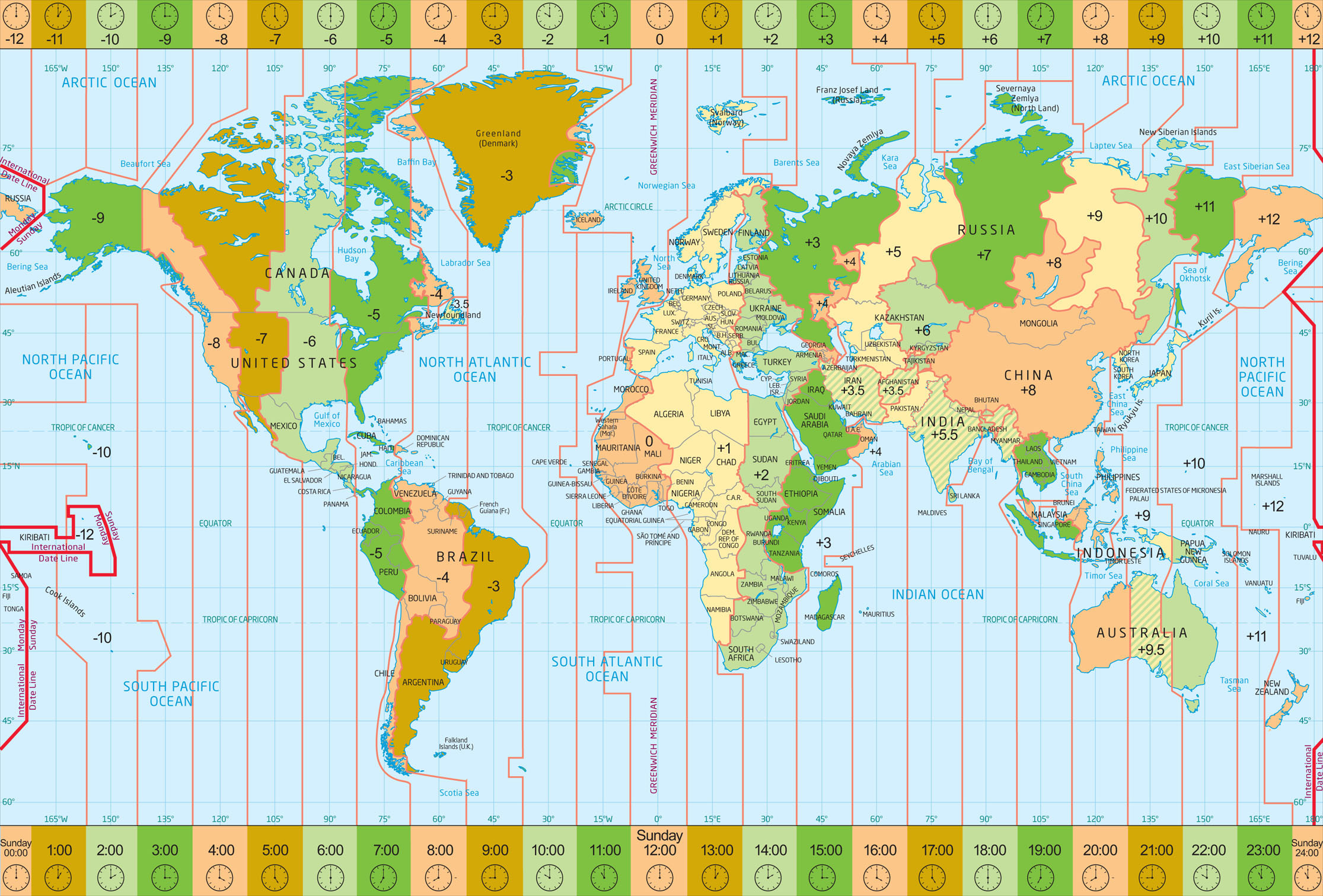
The latitude and longitude system of GCS also serves as the basis for breaking Earth up into multiple time zones to account for difference in time around the world. Time zones set up the concept of a 24-hour day, with each zone having a different time as it relates to the current time in Greenwich, England (also called Greenwich Mean Time or GMT). Earth is spanned by 360 degrees of longitude, and there are 24 hours in a day. 360 divided by 24 equals 15: there are 15 degrees of longitude for each hour. Thus, every 15 degrees away from the time zone containing the Prime Meridian marks the start of a new time zone (Figure 2.3).
38
39
40
 HANDS-ON APPLICATION 2.1
Great Circle Distance Calculations
To find the real-world shortest distance around the planet between two cities—New York and Paris—you’ll need to calculate the great circle distance between them. To calculate great circle distances quickly, use the Surface Distance application online at http://www.chemical-ecology.net/java/lat-long.htm. Use the option for Great Circle Distance Between Cities to find the real-world shortest distance between New York and Paris. Use it to find the city closest to where you are, and calculate the great circle distances between various pairs of cities. Also, use a program like Google Earth to obtain the GCS coordinates (latitude and longitude) for a location close to you and find the surface distance from there to a nearby city.
Expansion Questions:

Question
What is the great circle distance between New York and Paris?
-
Question
What is the great circle distance between the city closest to you and London, Paris, Rome, and Shanghai?
-
Question
Use Google Earth to obtain the GCS (latitude and longitude) coordinates (in degrees, minutes, and seconds) for a location near you and GCS coordinates for a location at the White House in Washington DC, and calculate the surface distance between the two points. How many miles are you from the White House?
 THINKING CRITICALLY WITH
GEOSPATIAL TECHNOLOGY 2.1
Do You Really Need Printed Maps in a Digital World?
Let’s face it, these days we’re living in a digital world—road maps, road directions, and property maps are all available in digital form with a few clicks of a mouse. With everything available digitally (and easily portable and accessible, thanks to laptops, tablets, and phones), is there still a need for printed maps? Do you really need to carry around a paper map version of the road network in Los Angeles, California, or will a mapping app on your smartphone suffice to find your location and get you where you want to go? Are paper map collections at universities and libraries relics of the past, or are they still useful resources? When might it be necessary to have access to such a collection?
When you’re driving a long distance, is it necessary to have a printed map of the area you’re traveling through when you’ve got GPS, satellite maps, and Internet mapping capabilities? If your answer is yes, describe a situation in which it would be necessary, and if your answer is no, why are printed maps still available?
From 7.5 degrees west longitude to 7.5 degrees east longitude is one time zone, 7.5 to 22.5 degrees longitude is a second time zone, and so on. Following these sections of longitude around the world, the east coast of the United States is five time zones to the west of the Prime Meridian, which makes the time New York and Boston five hours behind the time in Greenwich. The west coast of the United States is eight time zones to the west of the Prime Meridian (and three to the west of the United States east coast), which makes the time in San Francisco eight hours behind Greenwich (and three hours behind New York).
41
International Date Line a line of longitude that uses the 180th meridian as a basis (but changes away from a straight line to accommodate geography)
Take a closer look at Figure 2.3, and you’ll see that time zones don’t exactly follow the lines of longitude. Political or geographic boundaries are often the reason why a particular area is entirely in one time zone even though that area may straddle two zones, and why lines of longitude shouldn’t always be read as dividing lines between one time zone and the next. China, for instance, adopts one time measurement for the entire country, even though its geography crosses five time zones. The International Date Line marks the division between 24-hour periods and divides one day from another, but it also bends to accommodate considerations of geography, political boundaries, and convenience, and makes detours to include islands in one time zone or another, rather than strictly following the line of the 180th meridian.