2.4 
What Is UTM?
Universal Transverse Mercator (UTM) the grid system of locating coordinates across the globe
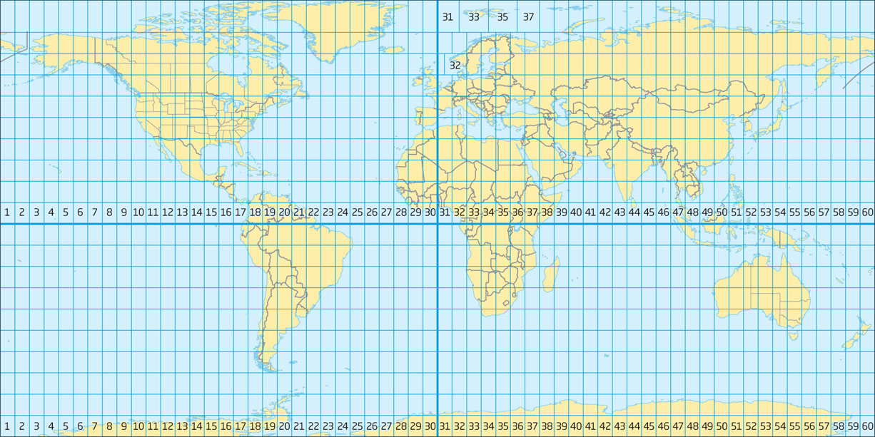
The Universal Transverse Mercator (UTM) grid system works by dividing the world into a series of zones, and then determining the x and y coordinates for a location in that zone. The UTM grid is set up by translating real-world locations to where their corresponding places would be on a two-dimensional surface (using the Transverse Mercator projection). However, UTM only covers Earth from between 84° N latitude and 80° S latitude (and thus can’t be used for mapping the polar regions—a different system, the Universal Polar Stereographic Grid System, is used to find coordinates in the Arctic and Antarctic).
UTM zone one of the 60 divisions of the world set up by the UTM system, each zone being 6 degrees of longitude wide
easting a measurement of so many units east (or west) of some principal meridian
northing a measurement of so many units north (or south) of a baseline
false northing a measurement made north (or south) of an imaginary line such as is used in measuring UTM northings in the southern hemisphere
The first step in determining UTM coordinates is to find which UTM zone the location is in. UTM (Figure 2.6) divides the world into 60 zones, each one 6° of longitude wide and set up as its own cylindrical projection. These zones are numbered 1 through 60, beginning at the 180th meridian and moving east. For instance, Mount Rushmore, outside of Keystone, South Dakota, is located in Zone 13. Beijing, China, is located in Zone 50. Sydney, Australia is in Zone 56.
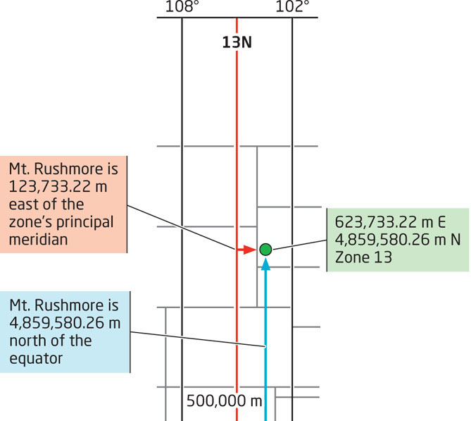
The next step is to determine the x and y grid coordinates of the point you want to locate. Unlike GCS, which uses degrees, minutes, and seconds, UTM uses meters as its unit of measurement. UTM’s x and y coordinates are referred to as the easting and northing coordinates. The UTM northing is found by counting the number of meters the point is north of the Equator. For instance, a particular location at Mount Rushmore is located 4,859,580 meters to the north of the Equator.
Locations in the southern hemisphere handle northing a little differently, since UTM doesn’t use negative values. For southern hemisphere locations, measure the distance in meters (as a negative value) from the Equator to the particular location, then add 10,000,000 meters to the number. For example, a location at the Opera House in Sydney, Australia (in the southern hemisphere), has a northing of 6,252,268 meters. This indicates it would be approximately 3,747,732 meters south of the Equator (−3,747,732 + 10,000,000). Another way of conceptualizing this is to assume that (for southern hemisphere locations) rather than measuring from the Equator, you’re measuring north of an imaginary line drawn 10,000,000 meters south of the Equator. This extra 10 million meters is referred to as a false northing since it’s a value set up by the system’s designers to avoid negative values.
45
false easting a measurement made east (or west) of an imaginary meridian set up for a particular zone
The next step is to measure the point’s easting. Unlike GCS, there is no one Prime Meridian to make measurements from. Instead, each UTM Zone has its own central meridian which runs through the zone’s center. This central meridian is given a value of 500,000 meters, and measurements are made to the east (adding meters) or west (subtracting meters) from this value. For example, a specific spot at Mount Rushmore is located 123,733.22 meters to the east of Zone 13’s central meridian—so the easting for this location at Mount Rushmore is 623,733.22 meters (500,000 + 123,733.22). A location in the town of Buffalo, Wyoming, is also in Zone 13, and has an easting value of 365,568 meters. This indicates that this location is approximately 134,432 meters to the west of Zone 13’s central meridian (500,000 − 134,432). No zone is more than 1,000,000 meters wide, so no negative values will be assigned to eastings in a zone. This value for easting is referred to as a false easting, since the easting calculation is based on an imaginary central meridian in each zone.
When UTM coordinates are written, the false easting, northing, and zone must all be specified. If a false northing is used (that is, the coordinates are found in a location south of the Equator), then a notation is included, explaining that the coordinates are from the southern hemisphere. For example, the UTM coordinates of a location at Mount Rushmore would be written: 623733.22 E, 4859580.26 N, Zone 13. (See Figure 2.7 for a simplified graphical example of finding the location at Mount Rushmore’s coordinates with UTM. Also, see Hands-on Application 2.3: Converting from Latitude/Longitude to UTM for converting latitude and longitude coordinates to UTM).
46
United States National Grid (USNG) a grid system of identifying locations in the United States
UTM values are also utilized as the basis for a related projected coordinate system, the United States National Grid (USNG), which is used extensively by the military and by disaster relief organizations like the Federal Emergency Management Agency (FEMA). USNG is particularly well-suited to emergency management and military applications since it uses a single identifier for the northing, easting, and zone information for every location—ensuring that the same coordinates are labeled and used in the same way by everyone. USNG measures coordinates in meters, using values derived from UTM northing and easting. It also uses UTM zone numbers in conjunction with smaller 100,000 m gridded zones to derive location information. Depending on the number of digits computed for the position measurement, USNG accuracy ranges between 1000 meters and 1 meter.
For example, the UTM coordinates of our previously computed Mount Rushmore location were 623733.22 E, 4859580.26 N, Zone 13. In the USNG system, using 1m precision, the coordinates of the same location would be written as a single string: 13TFJ2373359580—“13T” represents UTM zone 13, “FJ” identifies which one of smaller 100,000 meters grid zones the location is in, “23733” represents the value for easting (a shortened version of a UTM easting value of 623733), and “59580” represents the value for northing (a shortened version of a UTM northing value of 4859580).
47
 HANDS-ON APPLICATION 2.3
Converting from Latitude/Longitude to UTM
GCS and UTM are completely different systems, but there are utilities to make conversion from one system to another simple and easy. One of these is available at http://www.earthpoint.us/Convert.aspx. This Web resource can be used to convert from GCS to UTM. Input a coordinate for latitude and one for longitude, and click the Calc button. The corresponding UTM easting, northing, and zone will be computed for you and returned in a box below the inputs (along with other coordinate system conversions as well). You can also click View on Google Earth and a marker will be placed in Google Earth at the coordinates you specify.
First, you’re going to need GCS coordinates. A good source of GCS coordinates can be found at http://lat-long.com. This Website allows you to input the name of a location (try the Empire State Building) and the state (New York) or county, and it will return the lat/long (in both DD and DMS). Copy those coordinates into the converter, and click the Calc button to determine the UTM coordinates of the Empire State Building.
Expansion Questions:

Question
What are the UTM coordinates for the latitude and longitude coordinate given for a location at the Empire State Building?
-
Question
What are the UTM coordinates for the latitude and longitude coordinate given for the Jefferson Memorial in the District of Columbia, the Space Needle in Washington, and the Transamerica Pyramid in California?
-
Question
Use the two Websites in conjunction with each other to determine the UTM coordinates of prominent locations around your local area. What locations did you identify, and what are their UTM coordinates?