2.5 
What Is SPCS?
State Plane Coordinate System (SPCS) a grid-based system for determining coordinates of locations within the United States.
The State Plane Coordinate System (SPCS) is another grid-based system for measuring and determining coordinates. It was designed back in the 1930s, before computers. Today, SPCS is used as a coordinate system for United States data, especially city and county data and measurements. SPCS is a projected coordinate system that uses a translation method similar to UTM to set up a grid coordinate system to cover the United States. SPCS data was originally measured using the NAD27 datum, but now there are datasets using the NAD83 datum.
SPCS zone one of the divisions of the United States set up by the SPCS.
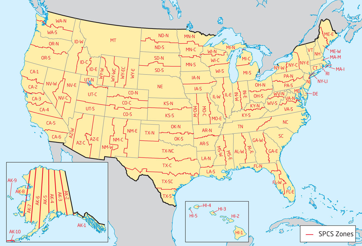
Like UTM, SPCS requires you to specify a zone, an easting, and a northing in addition to the state in which the measurements are being made. SPCS divides the United States into a series of zones. Unlike UTM Zones, which follow lines of longitude, SPCS zones are formed by following state or county boundaries. A state is often divided into multiple zones—for example, Ohio has two zones: Ohio-North and Ohio-South. Nevada has three zones: Nevada-West, Nevada-Central, and Nevada-East. Texas has five zones, and California has six, while all of Montana is represented by a single zone (Figure 2.8). To determine the coordinates for a point in SPCS, you must first know which state the point is in, and then you must identify the zone within that state. For example, to map data from Miami, the state is Florida and the zone is Florida-East, while Cleveland is in the state of Ohio and in the Ohio-North zone.
48
The next step is to determine the northing and easting. As with UTM, both of these are measured north and east from a predetermined baseline and meridian, but in SPCS, measurements are made in feet (using the NAD27 datum), or in feet or meters (using the NAD83 datum). Each of the SPCS Zones has its own baseline and its own principal meridian. Two projected versions of SPCS are used—the Transverse Mercator version, which is usually used for states that have a north-south orientation (like Indiana), and the Lambert Conformal Conic version, which is usually used for states that have a more east-west orientation (like Ohio). Baselines and principal meridians will be positioned differently, depending on which version is being used.
Baselines are placed a certain distance under the zone’s southern border and northings are measured from there (to ensure all positive values). In the NAD27 version, states using the Transverse Mercator format have their zone’s origin 500,000 feet to the west of the principal meridian, while states using the Lambert Conformal Conic projection have their zone’s origin 2,000,000 feet to the west of the meridian. Coordinates are determined by measuring distance using these false origin points, creating a false northing and a false easting. Thus, as each of the zones uses its own coordinate measurements, each zone has a different false northing and false easting from all other zones. Note that in the NAD83 version of SPCS, different values may be used for each zone’s origin.
49
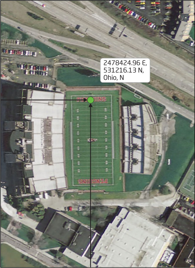
SPCS coordinates are referenced by listing the false easting, false northing, state, and zone. For example, the SPCS (NAD83 feet) coordinates of a location on the football field of Stambaugh Stadium in Youngstown, Ohio, are approximately: 2478424.96 E, 531216.31N, Ohio, N (North Zone; see Figure 2.9 for a simplified graphical representation of SPCS measurements—and see also Hands-on Application 2.4: Using the State Plane Coordinate System for a utility that will convert latitude and longitude coordinates into SPCS values).
50
 HANDS-ON APPLICATION 2.4
Using the State Plane Coordinate System
Like the conversion tool in Hands-on Application 2.3: Converting from Latitude/Longitude to UTM, there are Web-based utilities to convert GCS coordinates to their SPCS counterparts. A good one is available free online at: http://www.earthpoint.us/StatePlane.aspx, a Web resource similar to the one used in Hands-on Application 2.3. Enter the latitude and longitude coordinates of a location, click the Calc button, and it will calculate the SPCS coordinate for that location (it will also convert the other way, going from SPCS to GCS). Again, use the GCS coordinates you received from http://www.lat-long.com to compute the SPCS equivalents for them. Note however that you also have to specify the SPCS zone when entering the latitude and longitude of the points. When calculating the SPCS coordinates, you may want to use the View option on Google Earth to verify your results.
Expansion Questions:

Question
What are the SPCS coordinates for the latitude and longitude coordinate given for a location at the Empire State Building (New York Long Island Zone)?
-
Question
Working from their given latitude and longitude coordinates, what are the SPCS coordinates for the Jefferson Memorial in the District of Columbia (which uses Maryland’s Zone), the Space Needle in Washington (Washington North Zone), and the Transamerica Pyramid in California (California Zone 4)?
-
Question
Use the two Websites in conjunction to determine the SPCS coordinates of prominent locations around your local area (check with Figure 2.8 to identify which SPCS Zone you are located in). What locations did you choose, and what are their SPCS coordinates?