3.2 
What Is Georeferencing?
georeferencing a process whereby spatial referencing is given to data without it
Georeferencing is the process of aligning an unreferenced dataset with one that has spatial reference information. Other terms used for similar processes include “image to map rectification,” “geometric transformation,” and “registration.” Suppose you’re hosting a meeting at your school and you want the invitation to include a map to direct people not only to the school, but also to your specific building on the campus. You go to your school’s Website and download a map that shows the campus boundaries and specific building locations within those boundaries. So far so good—but you want to place that downloaded map in the larger context of a map of the city, so that people will be able to see where your campus is in relation to the surrounding roads and neighborhoods. The problem is that while the data you have of the surrounding area (whether aerial photos, satellite imagery, or GIS data layers) contains real-world spatial references, your downloaded map is just a graphic or PDF without any spatial reference at all. The campus map won’t match up with the spatially referenced data, and your plan of a snappy geospatial-style invitation will be ruined. Or will it? If you could just georeference that campus map, everything would fit together. Well, the good news is, you can. The georeferencing procedure requires a few steps of work to proceed, but you’ll be able to make your map (see Hands-on Application 3.1: David Rumsey Historical Map Collection and Figure 3.2 for an example of an online georeferenced map collection).
61
 HANDS-ON APPLICATION 3.1
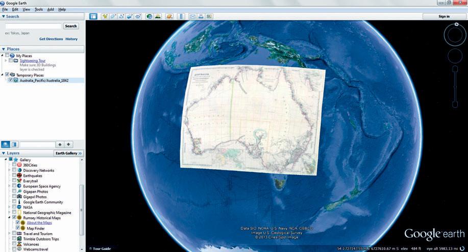
David Rumsey Historical Map Collection
Information about this ongoing project for the collection and preservation of historic maps can be found at http://www.davidrumsey.com. The maps on the Website are part of a collection that stretches from the seventeenth century to the present. While there are many ways of viewing these maps, some of the maps have been georeferenced to make them match up with current geospatial imagery. By looking at georeferenced maps in relation to current data, you can see how areas have changed over time. On the Website, select the link for Google Earth under the Quicklinks section, then select the option to View Google Earth in your Web browser (you’ll have to install a Google plug-in to make this work properly). Inside your Web browser, you’ll be able to interact with Google Earth just like in the last couple of labs, but you’ll also see special symbols on the map representing the location of where the georeferenced maps will open. Click on these symbols to see the maps appear, properly georeferenced in relation to Google Earth’s imagery. Check out some of the map icons for a variety of places around the globe and see how this historical information synchs up with modern boundaries and images.
The Rumsey Historical Map collection is also available as a layer in Google Earth itself. To use the maps as another Google Earth layer (like the roads or buildings), open the Gallery options, open the Rumsey Historical Maps option, and click on the Map Finder icon. You’ll see a new icon representing the maps appear in Google Earth that you can use to view the georeferenced maps. There’s also an “About the Maps” pop-up where you can read more information about the map collection and how these maps were scanned and georeferenced for use in Google Earth.
Expansion Questions:

Question
From examining some of the historic maps in both the Web interface and on Google Earth, how do the areas represented match up with their modern-day counterparts?
-
Question
Examine the “Chicago 1857” map. How does this historic map match up with modern day Chicago? You can use Google Earth to adjust the transparency of the map by using the tools in the Places Box (select the slider bar and move it about half way over)—this will enable you to see current imagery of Chicago beneath the georeferenced layer. Are there any areas that have changed significantly between then and now?
-
Question
Examine the “United States 1833” map (the ‘Eagle’ map with its icon located in Ohio), and make the layer semi-transparent. How does this map of the United States match up with current boundaries and coastlines?
62