3.3 
How Can Data Be Georeferenced?
control points point locations where the coordinates are known—these are used in aligning the unreferenced image to the source
When data (such as an old scanned map or other unreferenced data) is georeferenced, each location in that data is aligned with real-world coordinates. So to get started, you’re going to need a source of real-world coordinates to align your unreferenced data against. The choice of a source to use for the matching is important, because you have to be able to find the same locations on both the unreferenced image and the source. This is crucial to georeferencing, since the process needs some common locations to “tie” the unreferenced data to the source data. In the georeferencing process, these spots (where you can find the coordinates on the source data) are referred to as control points (sometimes called Ground Control Points or GCPs). Field work, such as surveying or making GPS measurements (see Chapter 4), can provide sources for these control points, but you can avoid having to go into the field by finding common locations on the unreferenced image and the source.
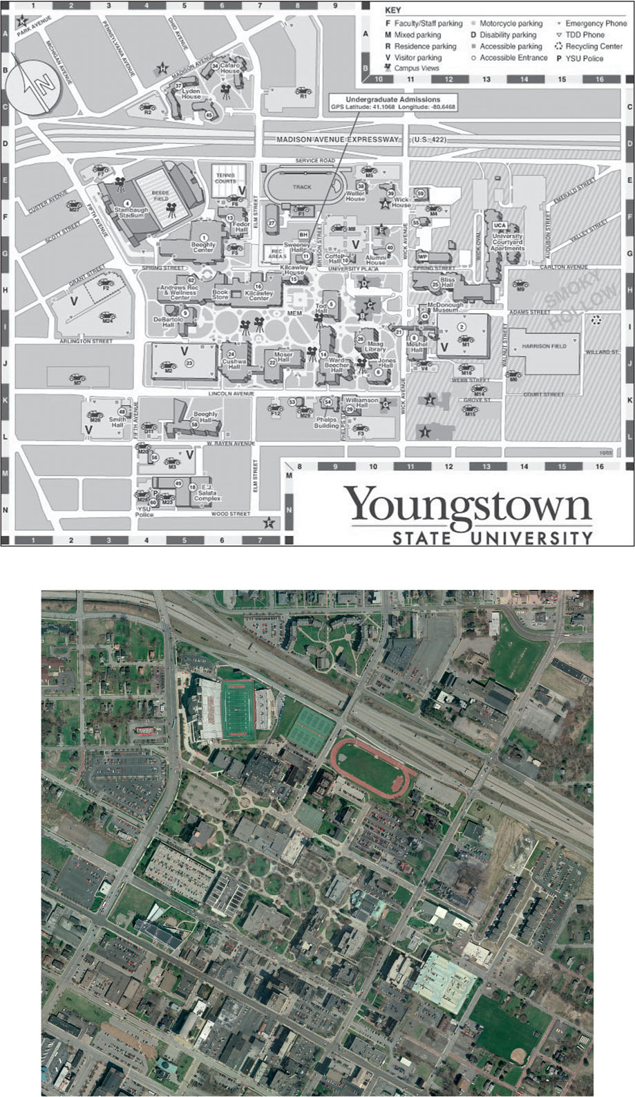
Clearly, the source should be something on which you can find the same locations as the ones you can see in your unreferenced data. For instance, a low-resolution satellite image isn’t going to be a good match with the detailed map of your campus buildings. Trying to match individual locations like buildings to an image like this isn’t going to work simply because the resolution is too low. A high-resolution image (where you can determine features of buildings) would be a more useful choice for this specific task. Datasets such as road networks (see Chapter 8) or orthophotos (see Chapter 9) are also good sources to use in finding these common points. In addition, your source data should be a similar projection to your unreferenced data. If the projections are different, some features will be forced to match up well and others will end up distorted. Whatever the source, the georeferencing process will align an unreferenced image against the projection and coordinates of the source map (Figure 3.3).
63
64
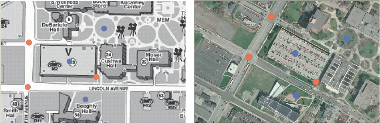
Where to select the control points is the key to the whole georeferencing procedure. Since control points are the objects that are going to connect the unreferenced data to the source data, they have to be placed in the same location in both sets of data, and real-world coordinates for these points will be required. By finding these same locations on the source (that has real-world coordinates) and on the unreferenced data (that doesn’t have real-world coordinates), we can start to match the two datasets together. Features that you can clearly find in the same spot in the unreferenced data and the source data will be good choices as locations for the placement of control points. For instance, the intersections of roads and the corners of buildings make good control point locations, because they’re well-defined and can be found on both sets of data. These are also locations that aren’t likely to change over time, so even if the unreferenced data and the source aren’t from the same time period, they’re usually valid as control point selections. Poor locations for control point selection spots would be those that can’t be accurately determined between the two sets of data, either because they’re poorly defined or because they might be in different places at different times—examples of poor control point selection choices would be a spot on the top of a building, the center of a field, the shoreline of a beach, or a shrub on a landscaping display. See Figure 3.4 for some examples of good and poor control point location selections on the campus map.
Another consideration to keep in mind when you’re selecting control point locations is to not bunch them all together in one area of the data and ignore the rest of the map. Placing all of the control points at spots in one-quarter of the image is going to ensure that section of the map is well referenced while the rest of the map may not fit very well. Make sure to spread out the control points to representative locations throughout the data so that all areas fit well in relation to their newly‑referenced spots. You’ll want to use several control points in the process—some georeferencing processes may only need a few, while others may require many more.
The minimum number of control points required to fit the unreferenced image to the source is three. Three control points are often enough to enable you to make a rough fit of the image to the source. With this initial fit, some programs (for instance, MapCruncher, the program used in this chapter’s Geospatial Lab Application) will attempt to match up the next control point location with a spot you select on the source. As you add more control points, the fit between the unreferenced data and the source should (hopefully) improve. Proper selection of control points is critical for georeferencing, since the procedure needs to have some sort of real-world coordinates to match to, and it’s these points that will be used to calculate coordinates for the other locations in the image. Often, you’ll find that deleting a control point, adding another one, and tinkering with the placement of others is necessary to get the best fit of the data (see Hands-on Application 3.2: Online Georeferencing Resources for several online examples of placing control points in relation to old maps). Once your data is properly aligned by using control points, you can then transform it to have the same coordinate system information as the source.
65
 HANDS-ON APPLICATION 3.2
Online Georeferencing Resources
Georeferencing of maps has become a popular online activity. Several free georeferencing tools are available for anyone who wants to create spatially referenced versions of maps, especially old ones. You can select control points and transform the old maps to match up with current ones. For instance, the British Library is encouraging people to use online georeferencing tools to align and save old maps so that they can become part of the collection. Check out the following online resources to become part of the georeferencing effort (some sites will ask you to register for free before you can do any georeferencing, but you can usually view completed maps without registering):
- The British Library Online Gallery: http://www.bl.uk/maps
- The National Library of Scotland Map Georeferencer: http://maps.nls.uk/projects/georeferencer
- The New York Public Library Map Warper: http://dev.maps.nypl.org/warper
- Old Maps Online Georeferencer: http://www.georeferencer.org
- WorldMap Warp at Harvard University: http://warp.worldmap.harvard.edu
Expansion Questions:

Question
What kinds of historic georeferenced maps are available on these sites? How do the already georeferenced maps match up with modern maps?
-
Question
What kinds of difficulties did you find in trying to match unreferenced historic maps to modern maps (especially when it comes to selecting control points)?