4.4 Why Isn’t GPS Perfectly Accurate?
If GPS can be used to find a location on Earth’s surface, the next question to ask is “just how accurate is GPS?” Through the use of pseudorange measurements from four satellites, you might reasonably expect the system to give the user one accurately measured location. However, in normal everyday use with an ordinary off-the-shelf civilian receiver, accuracy is usually somewhere around 10–15 meters horizontally. This doesn’t mean that the location is always off by 15 meters—it could be off by 5, 10, or 15 meters. This is due to a number of factors that can interfere with or delay the transmission or reception of the signal—and these delays in time can cause errors in position.
selective availability the intentional degradation of the timing and position information transmitted by a GPS satellite
One of the biggest sources of error was actually worked into the system intentionally to make GPS less accurate. The United States introduced selective availability (SA) into GPS with the goal of intentionally making the C/A signal less accurate, presumably so that enemy forces couldn’t use GPS as a tool against the United States military. Selective availability introduced two errors into the signals being transmitted by the satellites—a delta error (which contained incorrect clock timing information) and an epsilon error (which contained incorrect satellite ephemeris information). The net effect of this was to make the accuracy of the C/A about 100 meters. As you can imagine, this level of accuracy certainly limited GPS in the civilian sector—after all, who wants to try to land an airplane with GPS when the accuracy of the runway location could be hundreds of feet off? In the year 2000, the U.S. Government turned Selective Availability off and has no announced plans to turn it back on (in fact, the U.S. Department of Defense has announced that new generations of GPS satellites will not have the capability for selective availability).
While selective availability was an intentional error introduced into the signals broadcast by the satellites, other errors can occur naturally at the satellite level. Ephemeris errors can occur when a satellite broadcasts incorrect information about orbit position. These types of errors indicate that the satellite is out of position, and the ephemeris data needs to be corrected or updated by a control station. Typically, these errors can introduce 2 meters or so of error.
89
PDOP the position dilution of precision—it describes the amount of error due to the geometric position of the GPS satellites
Even the arrangement of satellites in space (that is, how they are distributed) can have an effect on the determination of position. The further the satellites are spread out from one another and the wider the angle between them, the more accurate a measurement obtained by the receiver will be. The error introduced by a poor geometric arrangement of the satellites is referred to as the position dilution of precision or PDOP. Some receivers will calculate a value for PDOP for you to indicate what relative error could be introduced because of the arrangement of the satellites being used (basically, the lower the value the better).
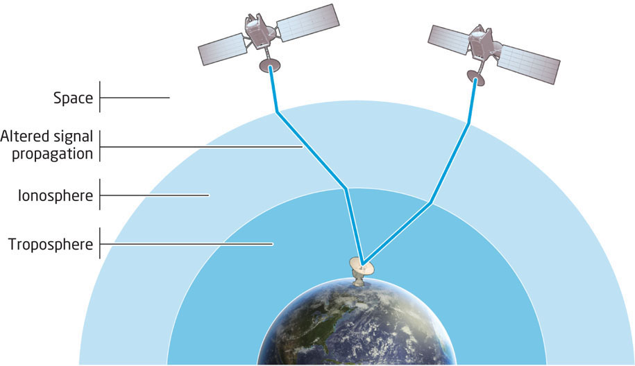
You should also keep in mind that the signals are being broadcast from space and have to pass through Earth’s atmosphere before reaching the receiver. Though some of these atmospheric effects can be modeled, and attempts can be made to compensate for them, atmospheric problems can still cause errors in accuracy by making changes to the speed of the signals (Figure 4.7). Atmospheric interference, especially in the ionosphere and troposphere, can cause delays in the signal on its way to the ground. The ionosphere can alter the propagation speed of a signal, which can cause an inaccurate timing measurement, while the amount of water vapor in the troposphere can also interfere with the signals passing through it and also cause delays. It’s estimated that the problems caused by conditions in the ionosphere can cause about 5 meters (or more) of position inaccuracy, while conditions in the troposphere can add about another 0.5 meters of measurement error.
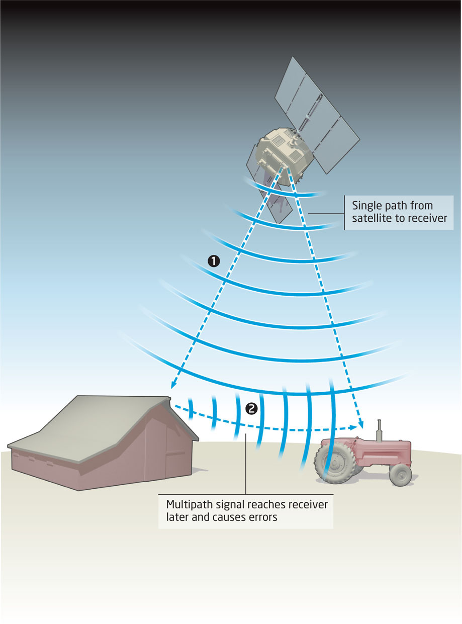
multipath an error caused by a delay in the signal due to reflecting from surfaces before reaching the receiver
The atmosphere is not the only thing that can interfere with the signal reaching the receiver. The receiver needs a good view of the sky to get an initial fix, so things that would block this view (like, say, a heavy tree canopy) may interfere with the signal reception. In addition, the signals may be reflected off objects (such as tall buildings or bodies of water) before reaching the receiver rather than making a straight path from the satellite (Figure 4.8). This multipath effect can introduce additional delays into the reception of the signals, since the signal is reaching the receiver later than it should (and will add further error to your position determination).
90
It’s quite possible for any or all of these various types of error measurements to combine together to contribute several meters worth of errors into your position determination. When the ephemeris introduces a few meters of error, and the ionosphere and troposphere add a few more, and then multipathing and PDOP add a few more on top, before you know it they’re starting to add up to a pretty significant difference between your position as plotted and where you actually are. So, there should be some manner of solutions to improve the accuracy of GPS and get a better fix on your position.
91