5.5 
What Kinds of GIS Are Available?
Esri the Environmental Systems Research Institute, a key developer and leader of GIS products
There are many different types of GIS software packages available, everything from free lightweight “data viewers” to numerous Open Source programs, to expensive, commercially available software packages. There are numerous companies producing a wide variety of GIS software. According to a 2007 GIS Salary Survey conducted by the Urban and Regional Information Systems Association (URISA), GIS products from the Environmental Systems Research Institute (Esri) were found to be among the most popular and widely-used.
Arc/Info an Esri GIS product that required command-line entry for tools and capabilities
ArcView an Esri GIS product developed with a Windows interface
Located in Redlands, California, Esri was founded by Jack and Laura Dangermond in 1969. By 1982, Esri had released the first of its “Arc” products, the initial version of Arc/Info, a key GIS software package. Though it was extremely powerful in its analytical capabilities, Arc/Info was also a product of the DOS command-line era of computing. This meant there were literally hundreds of different Arc/Info commands, each with numerous variations in their use, options, and syntax. Esri would later release ArcView, a Windows-based tool for viewing and examining geospatial data. ArcView had some features in common with a graphical user interface, such as pull-down menus, icons, and windows, and this made it much simpler to use than the command-line interface. ArcView went through several iterations—to add a greater variety of functions, and to expand and improve its analytical capabilities—and by the late 1990s it was very widely used. The final version of ArcView was version 3.3.
ArcGIS Esri’s current primary GIS software package
Esri released its newest software package, ArcGIS (version 8, which built off the numbering of the previous Arc/Info versions) in stages between 1999 and 2001. ArcGIS was a blend of the analytical capabilities of Arc/Info with a Windows graphical interface (similar to ArcView) in one package. As of this writing, the most recent iteration of the software is ArcGIS for Desktop 10.2. ArcGIS for Desktop 10.2 is available in three different varieties: ArcGIS Basic, ArcGIS Standard, and ArcGIS Advanced. These can best be thought of as different levels of the same software package—all of them are considered ArcGIS for Desktop, but the Basic version has the smallest number of functions, the Standard version has the mid-range of functions, and the Advanced version has the largest number of functions.
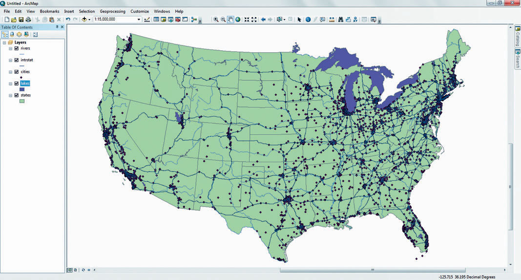
ArcMap the component of ArcGIS used for viewing and analyzing data
Catalog the component of ArcGIS used for managing data (which contains the functionality of the previous ArcCatalog)
No matter which of the three versions of ArcGIS you’re using, the main component is referred to as ArcMap, which is used for viewing and analyzing data (see Figure 5.10). Within ArcMap, GIS datasets can be added and treated as different map layers. ArcGIS offers multiple sets of tools for analysis, data manipulation, and to enable you to make maps from your data (things you’ll be doing in the labs for Chapters 6, 7, and 8). Previous versions of ArcGIS also featured ArcCatalog, a separate utility for managing available GIS data. In ArcGIS 10.2, the Catalog functions are contained as a feature within ArcMap itself.
125
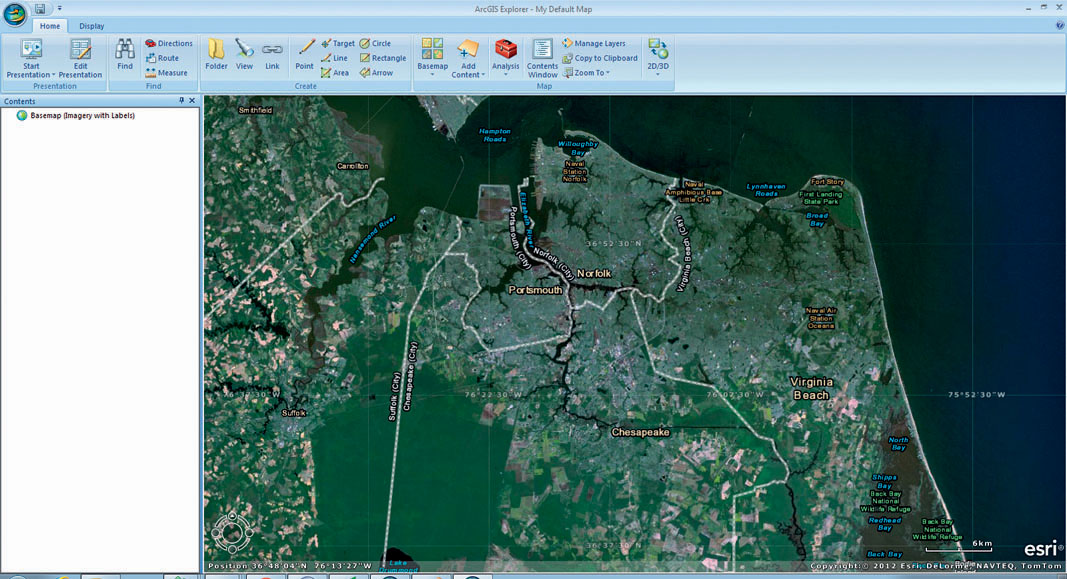
ArcGIS Explorer a virtual Earth tool that can be downloaded for free from Esri
ArcGIS Explorer is a free downloadable tool that Esri touts as being “GIS For Everyone” (see Figure 5.11). ArcGIS Explorer has multiple functions for handling GIS data, and other data made available for use from Esri’s cloud resources in ArcGIS Online (you’ll work with some of ArcGIS Explorer’s capabilities later in Chapter 15). See Hands-on Application 5.5: Esri ArcNews, ArcUser, and ArcWatch for more information about Esri software and applications.
With the proliferation of numerous Esri products on the market and in use today, it’s no surprise that a lot of the available GIS data is in an Esri data format. Raster data is widely available in (or can be easily imported into) Esri Grid format, which can be directly read by Esri software. Vector data can usually be found in one of the following three different varieties: coverage, shapefile, and geodatabase.
126
 HANDS-ON APPLICATION 5.5
Esri ArcNews, ArcUser, and ArcWatch
Esri data and software products are used in numerous applications across the globe. To keep informed about new Esri updates, software, and real-world uses of GIS, Esri publishes a pair of print publications (and makes articles and content available free online) as well as an e-magazine. Check the following sites for their publications and look for articles related to fields of interest to you:
- ArcNews: http://www.Esri.com/news/arcnews/arcnews.html
- ArcUser: http://www.Esri.com/news/arcuser/index.html
- ArcWatch: http://www.Esri.com/news/arcwatch/index.html
Expansion Questions:

Question
How is Esri software enabling current developments in environmental monitoring, national security, urban planning, and law enforcement?
-
Question
What new developments are currently underway in the GIS field?
coverage a data layer represented by a group of files in a workspace consisting of a directory structure filled with files and also associated files in an INFO directory
Coverage is the original file format for Arc/Info. The coverage itself consists of multiple files inside of a directory structure. The folder that a coverage is stored in is referred to as a workspace, and a workspace may contain multiple coverages. A workspace will also contain a separate folder called the INFO directory, which contains extra files as needed by each coverage in the workspace. Because a coverage is structured to be capable of holding multiple files, Esri has created a method for taking all the necessary files that make up one coverage and exporting them to a single file for portability. This exported file (which is called an “interchange file,” and ends with the file extension .e00) can then be moved to a different location and reimported to rebuild the coverage structure on another folder or computer.
shapefile a series of files (with extensions such as .shp, .shx, and .dbf) that make up one vector data layer
Shapefile is the original file format for ArcView. A shapefile can hold only one type of vector object—thus there are point shapefiles, line shapefiles, and polygon shapefiles. Despite the name, a shapefile actually consists of multiple files that have to be present together to properly represent the data. The files all start with the same prefix (that is, if the shapefile is called “roads,” then all the files that it consists of will be called “roads”) but will have different extensions, including .shp, .shx. .dbf, and others. When copying a shapefile, you need to move all files with the same prefix to their new location for the shapefile to function properly.
geodatabase a single file or folder that can contain multiple layers, each as its own feature class
Geodatabase is the file format established for ArcGIS. A geodatabase consists of a single file or folder that contains all of the geospatial information for a dataset. Its object-oriented structure is set up so that multiple layers can be stored in a single geodatabase, each layer being its own feature class. For example, a geodatabase called “Yellowstone” could store the park boundaries as a polygon feature class, the roads running through the park as line feature classes, and the hiking trails as another line feature class. Geodatabases can also contain feature datasets, or subgroups of feature classes organized together. In addition, geodatabases can also store other data used in GIS, such as tables and rasters, and they can have GIS data in other formats (such as shapefiles) imported into them.
127
Esri isn’t the only company making GIS software—there are several other software packages and GIS companies providing a wide range of products that are used throughout the industry. No list of such things can hope to be comprehensive, but here are some of the more notable commercial GIS software products (and their vendors):
- Geomedia (from Intergraph)
- IDRISI Selva (from Clark Labs)
- Manifold System (from Manifold)
- MapInfo Professional (from Pitney Bowes Business Insight)
- Maptitude (from Caliper Corporation)
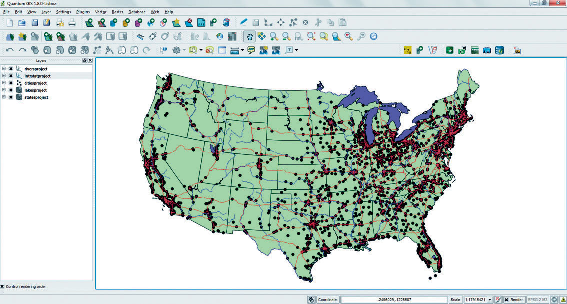
QGIS an open source GIS program
There are also several open source GIS products available for use and download via the Internet. An example is GRASS (Geographic Resources Analysis Support System), a long-running free (and open source) GIS software that can handle vector, raster, and image data with many different types of analysis. Quantum GIS (QGIS) is another prominent open source GIS program (that you’ll have the opportunity to use in this chapter’s Geospatial Lab Application 5.1). QGIS is freely available for download, can use many types of GIS data formats, including shapefiles and rasters, and has a layout similar to that of ArcMAP (see Figure 5.12). QGIS features multiple types of analytical capabilities as well as mapping and data creation tools.
128