8.4 
How Are Networks Used in Geospatial Technology?
All of the things discussed in this chapter are used for a variety of applications with geospatial technology. Through GIS, these types of network data can be created and utilized in various ways. The vehicle navigation systems integrate many of these concepts together—using GPS to pinpoint the device’s location on a map, then using network base data, geocoding, and shortest paths to navigate through locales worldwide. Other options on these systems involve utilizing real-time data broadcast into the device to determine areas of congestion, high traffic, construction, or road accidents. This data can then be used in the shortest-path process to route you around these types of obstacles or impediments to your travel. These same maps and technological resources are being integrated into smartphones and mobile devices to put GPS locations, mapping, geocoding, shortest-paths, and real-time routing information capabilities into the palm of your hand (Figure 8.9). As we have noted, however, these devices are often only as accurate as the base maps they’re utilizing, so regular updates are usually made available, or users are given the option to make their own updates.

Street View a component of Google Maps and Google Earth that allows the viewer to see 360-degree imagery around an area on a road
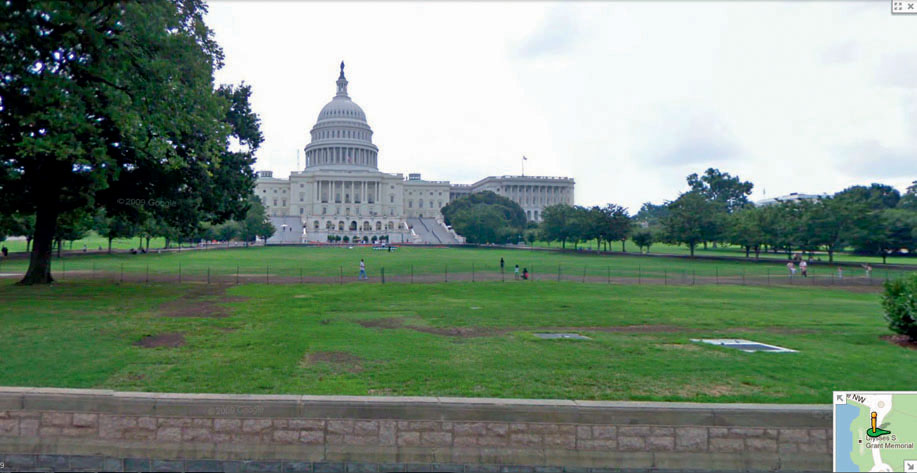
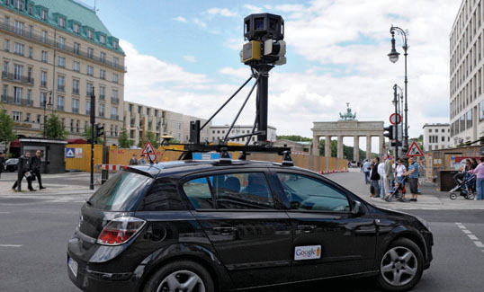
The same types of network base maps are used online for services like MapQuest, Bing Maps, Yahoo! Maps, and Google Maps (see Hands-on Application 8.4: Online Mapping and Routing Applications and Shortest Paths), which allow you to perform geocoding, and to obtain directions for the shortest path between points. Street View allows Google Maps (or Google Earth) users to examine 360 degrees of location photography—on a street, say, as if you’d just stopped your car right there to take a look around. With this function, you can examine canned photography of an address or destination when you’re planning a stop (Figure 8.10). Cars equipped with special cameras capable of capturing a 360-degree view travel the nation’s roads, taking in imagery along the way (see Figure 8.11 and Hands-on Application 8.5: Examining Google Street View). Google’s even extending their Street View into places inaccessible by motor vehicles—by attaching the same type of camera equipment to bicycles and checking out the hiking and biking trails.
260
With this level of data availability, and geospatial networks being integrated into so many different applications, mapping (and providing accurate and up-to-date base maps) has become big business. Companies such as Tele Atlas and NAVTEQ produce these maps, and their products are often what you’re accessing on an online service, or through a vehicle navigation system. Next time you access one of these kinds of services, look for the copyright data somewhere in the map to see which company is producing the map data you’re using. NAVTEQ, for instance, sends teams out in high-tech cars to collect data on the location and attributes of new roads, housing developments, and other items for updates of maps (as well as photography equipment to produce items like the Street View scenes).
261
 HANDS-ON APPLICATION 8.5
Examining Google Street View
Google Street View is a very useful application that gives you a look at what the street network would look like if you were driving or riding past. Open your Web browser and go to Google Maps at http://maps.google.com, and then enter a particular address—try typing in the address of the Rock and Roll Hall of Fame in Cleveland, Ohio (1100 Rock and Roll Blvd., Cleveland, OH), and zoom in until you can see the distinctive building of the Rock Hall and its surrounding streets. Above the zoom slider on the left side of the map you’ll see an orange icon that looks like a person (called the “pegman”). Grab that with the mouse and place it on top of the street in front of the Rock Hall (E. 9th Street). Streets that have been covered by Google Street View will be highlighted in dark blue. Place the icon on one of the available streets and the view will shift to photography of that area (see Figure 8.10 for an example). Use the mouse to move the view about for 360-degree imagery of the area. You’ll also see some white lines and arrows superimposed on the road—clicking on them will move you along the street and you’ll see the imagery change. Move around until you can get a good street-level view of the Rock and Roll Hall of Fame.
Expansion Questions:

Question
How would the imagery from Street View be helpful if you were traveling to the Rock Hall as a destination (and had never been there before)? There are no parking areas available immediately adjacent to the Rock Hall—how could Google Street View be more helpful to you than a road map or an overhead view in finding somewhere to park?
-
Question
Examine some local areas near you using Street View. Which roads are available with Street View imagery and which are not (for instance, is Street View imagery of residential areas available or is it available only on main roads)?
 THINKING CRITICALLY WITH
GEOSPATIAL TECHNOLOGY 8.2
What Kind of Issues Come with Google Street View?
Open your Web browser and go to Google Maps at http://maps.google.com, and then enter the address of the White House (1600 Pennsylvania Avenue, Washington, D.C., 20500). When you try to move the Street View pegman to view the roads, you’ll see that the streets immediately surrounding the White House are unavailable to view in Street View, presumably for security purposes. However, most of the surrounding streets can be viewed using Street View, allowing you to look at the exteriors of shops, residences, and other government buildings. Can the images being collected by Street View pose a security risk, not just for government areas, but for the private security of homes or businesses?
An article in the May 31, 2008, issue of the Star Tribune (available online at http://www.startribune.com/lifestyle/19416279.html) describes how the community of North Oaks, Minnesota, demanded that Google remove its Street View images of the privately owned roads in the area, citing laws against trespassing. Is Street View encroaching too far on people’s private lives, or not? Keep in mind that you can view or record the same things quite legally by driving or walking down the same streets.
262