9.1 
How Did Aircraft Photography Develop?
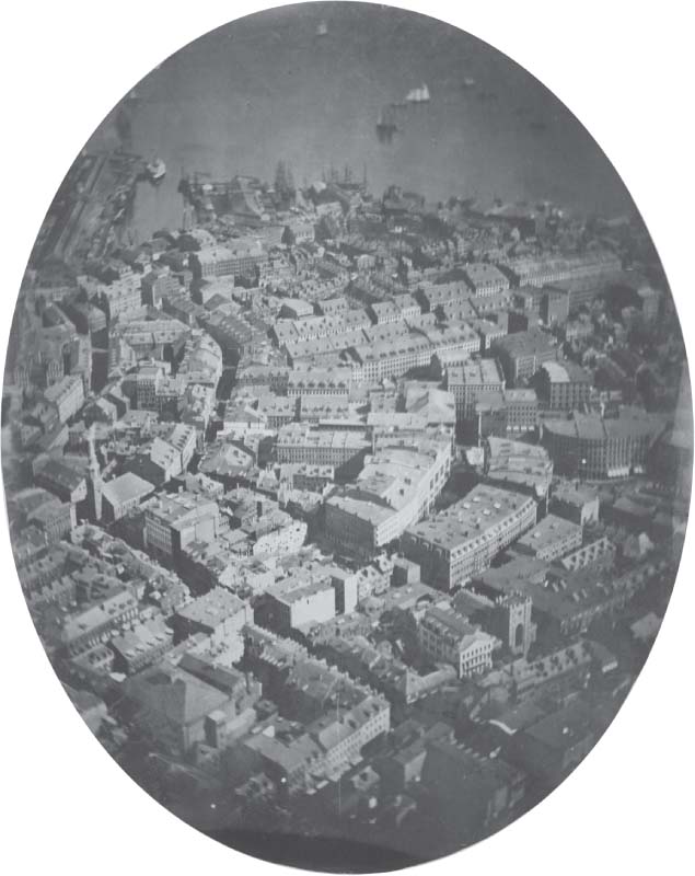
A French photographer named Gaspar Felix Tournachon (known as “Nadar”) took the first aerial photograph. In 1858, Nadar strapped himself into the basket of a hot-air balloon, and captured an image of a landscape outside Paris. This first aerial photograph no longer exists, but this was clearly the beginning of something big. In 1860, aerial photographs were taken of Boston by James W. Black from a balloon above the city (Figure 9.1). However, development times, problems with landing at a prearranged location, and interference with the photographic plates from the balloon’s gas all contributed to the view that balloons were not a practical platform for capturing aerial photographs.
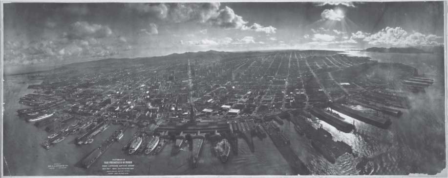
By the end of the nineteenth century, photographic equipment was attached to kites (or a series of kites) and used to photograph the landscape remotely—while the photographer was safely on the ground. A famous example of kite photography comes from 1906, when a photographer named George Lawrence used a set of kites 1000 feet above San Francisco Bay to capture an aerial image of the city, in the wake of the 1906 earthquake: he called it “San Francisco in Ruins” (Figure 9.2). These early images taken from the air set the stage for the use of aircraft as platforms for aerial photography.
301
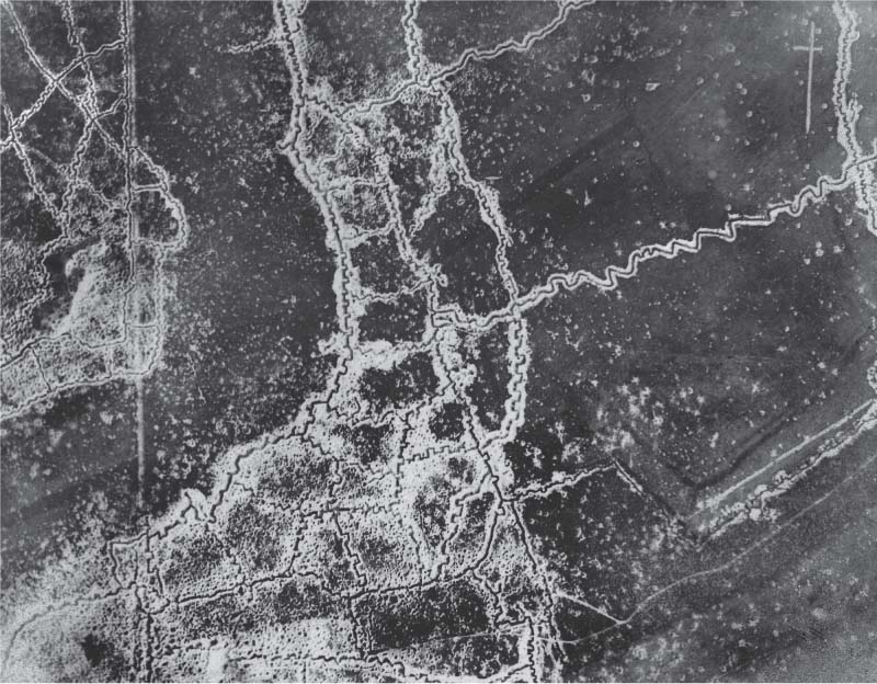
The history of modern aviation started in 1903, with the first flight of the Wright Brothers at Kitty Hawk, North Carolina. In 1908, a cameraman took the first photograph from an airplane as he flew with Wilbur Wright near Le Mans, France. During World War I, aerial photography from an airplane was commonly used for mapmaking, and the planning of military tactics. Aerial photography of the battlefields allowed for the patterns of trenches to be determined, enemy positions to be observed, troop movements and encampments to be plotted, and the location of artillery or supplies to be found. Countless aerial photos were shot and developed over the course of the war, and aerial photography opened up new areas in military intelligence. See Figure 9.3 for an example of trench formations captured by an aerial camera.
302
Aerial photography continued to be extremely important for tactical planning and reconnaissance during World War II. Both the Allies and the Axis forces depended heavily on aerial photography for obtaining vital information about locations prior to military action, and it became a key reconnaissance technique. For instance, a V-2 rocket base in Peenemunde, Germany, was the subject of British aerial photography in June of 1943, and bombing strikes destroyed the base less than two months later. Similarly, aerial reconnaissance was used in obtaining photographs of German dams and the subsequent “dam-busting” bombing missions to destroy them. A huge amount of aerial photography was performed during the war, and a good source of historical imagery is The Aerial Reconnaissance Archives (TARA), currently held at the Royal Commission on the Ancient and Historical Monuments of Scotland (RCAHMS), which hosts a large archive of European World War II aerial photos (see Hands-on Application 9.1: World War II Aerial Photography Online for a glimpse of these historic photos).
UAV unmanned aerial vehicle—a reconnaissance aircraft that is piloted from the ground via remote control
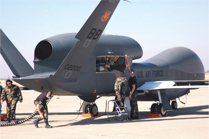
Post–World War II aerial photography remained critical for military applications, especially for spy planes. The 1950s saw the development of the U-2 spy plane, capable of flying at 70,000 feet, traveling at over 400 mph, and photographing the ground below. The U-2 was used for taking aerial photos over the Soviet Union, but also enabled the acquisition of imagery showing the placement of missile launchers at key points in Cuba during the Cuban Missile Crisis of October 1962 (Figure 9.4). Spy plane technology continued to advance with the development of the Lockheed SR-71 Blackbird, which could fly at over 80,000 feet and travel at more than three times the speed of sound (Figure 9.5), thus enabling it to go higher and faster than the U-2. The Blackbird was an essential aerial photography plane through the Cold War and beyond, until it was retired in the late 1990s. Today, digital aerial photography (among many other types of remotely sensed data) is obtained by unmanned aerial vehicles (UAVs). These planes are piloted from the ground via remote control and are currently being used by the military for aerial reconnaissance in Iraq and Afghanistan. There are numerous types of UAVs, ranging from smaller drones like the Predator to larger ones such as the RQ-4 Global Hawk (which is planned to eventually replace the U-2 for aerial reconnaissance—see Figure 9.6). Outside of military uses, aerial photography is used extensively by state and local governments or private companies for many different kinds of data collection.


303
304
 HANDS-ON APPLICATION 9.1
World War II Aerial Photography Online
The National Collection of Aerial Photography is a great online resource for viewing aerial photography of Europe during World War II. Open your Web browser and go to http://aerial.rcahms.gov.uk and select the option for Worldwide Gallery, which contains imagery from several countries. Select a location (such as France or Germany), then select a region. Check out some of the countless historic aerial photos that have been archived online.
Expansion Questions:
 A highlighted section of the National Collection of Aerial Photography showcases the “detective work” that has uncovered new information about historic events from the aerial archive. Look at: http://aerial.rcahms.gov.uk/news/hiddensecrets.php. What kinds of images linked to historic events have been found, and what kind of information has been gathered from them?
- Click on the Features section of the Website for access to several showcased historic aerial photos (and lessons on working with aerial photography). Select the option for The D-Day Landings and examine the aerial photos in this section. What aspects of the actions of the D-Day invasion have been captured through aerial photography? What particular features of the invasion can you interpret from the images?
- Also in the Features section, select the option for Camouflage, Concealment, and Deception. It’s hard to hide something as big as an airfield or a warship from overhead cameras—but look closely at the images in this section. How were airfields, warships, oil refineries, and rocket launching sites concealed from aerial photos?
 THINKING CRITICALLY WITH
GEOSPATIAL TECHNOLOGY 9.1
How Can UAVs Be Used for Security Purposes?
UAVs are not limited to military operations. Aircraft that can be piloted via remote control and equipped with multiple types of aerial surveillance equipment have a variety of other uses. For example, a May 2013 article (available online at http://www.newswise.com/articles/university-police-to-develop-uavs-for-campus-security) indicates that the University of Alabama Huntsville is looking into using UAV drones to aid in campus security, while a December 2012 article in the Washington Times (available online at http://www.washingtontimes.com/news/2012/dec/10/homeland-security-increasingly-loaning-drones-to-l/) noted that a U.S. Department of Homeland Security UAV was utilized for local police surveillance in North Dakota in 2011. How else can UAVs be utilized for functions such as border security or law enforcement? How could police or federal agents utilize UAV capabilities for gathering intelligence about dangerous situations or acquiring reconnaissance before entering an area? Also, if UAVs are being used to remotely monitor civilian conditions, what potential is there for abuse of these methods of data collection? Is UAV surveillance in a domestic urban environment an invasion of privacy?
305