9.3 How Can You Interpret Objects in an Aerial Image?
Understanding what you’re looking at when you’re viewing Earth from the sky instead of from ground level takes a completely new skill set. Objects that you’re used to looking at head-on have a whole different appearance from directly above. For example, Figure 9.11 shows two different views of the Stratosphere Hotel and Casino in Las Vegas, Nevada—one showing an overhead aerial view and the other an oblique photograph showing details of the tower and its buildings. Obviously, the complex looks completely different from the oblique angle than from directly above. If you look closely, you can see where areas in the two photos match up, such as the tower on the right-hand side of the image and the remainder of the hotel and casino on the left. However, if you’re only given the aerial image and asked what building this is (of all possible structures in the world), it’ll be a whole different ballgame.
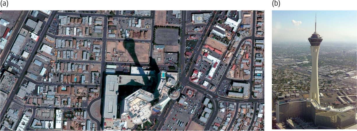
From the aerial image alone, you’ll have to search for clues to determine what’s really being shown. For instance, based on the size of the complex (roughly a city block) you’ll probably guess that it’s some sort of hotel, resort, entertainment attraction, or museum. By looking at its location amidst other large buildings and multiple-lane roads, you may guess that the building’s in a big city. On closer examination, you might make out a different colored object (the light blue) among the main complex and determine that it’s a swimming pool, which narrows the chances further on the building being some sort of hotel or resort. Although the height of the tower on the right-hand side of the image isn’t really discernible (since the image was taken looking down onto the tower itself), the huge shadow cast by the tower (stretching upward) is visible. Based on the length of the shadow (and the shape of the shadow being cast), you may determine that the object casting it is a tower (or a similar very large, very tall object). Putting all of these clues together (city-block-sized hotel/resort in a big city with a massive tower in front of it), you should be able (with the help of some outside information, like a few travel books and maybe a quick Web search) to determine pretty quickly that you’re looking at the Stratosphere Hotel in Las Vegas.
313
visual image interpretation the process of examining information to identify objects in an aerial (or other remotely sensed) image
pattern the arrangement of objects in an image: an element of image interpretation
When you try to interpret features in an aerial photo or a satellite image (for instance, objects in developed areas or physical features in a natural landscape), you act like a detective searching for clues in the image to figure out what you’re really looking at. As in the Stratosphere Hotel example, clues like the size and shape of objects, or the shadows they cast, help to determine what you’re really looking at. Visual image interpretation is the process of identifying objects and features in an aerial (or other remotely sensed) image based on a number of distinct elements:
 Pattern: This is the physical arrangement of objects in an image. How objects are ordered (or disordered) will often help to interpret an image. A large array of cars set up as if for inspection in a parking lot around a relatively small building will probably be a car dealership rather than some other type of shopping area. Evenly spaced rows of jet airplanes suggest a military base, while a haphazard arrangement of aircraft could be a group of statics on display at an aircraft or military museum.
site and association the information referring the location of objects and their related attributes in an image. Used as elements of image interpretation
- Site and association: Site deals with the location characteristics of an item, while association relates an object in an image to other nearby features in the image. For example, a football field itself has enough distinctive features to identify it, but the related phenomena you could see in the image (the number of bleachers, the number and distribution of the seats, and perhaps the amount of nearby parking) would help in determining if you’re looking at a field used by a high school team, a 1-AA college team, or a professional NFL team.
size the physical dimensions (length, width, and area on the ground) of objects. An element of image interpretation
- Size: This describes the length, width, and area on the ground of objects in the image. The relative size of objects in an image can offer good clues in visual image interpretation. For instance, the average length of a car is about 15 feet. If a car is present in an image, you can gain information about other objects by comparing their length with that of the car—you can tell, for instance, if a structure near the car is the size of a house or a shopping center. The sizes of some features remain the same, whatever the image. If baseball diamonds or football fields are present in an image, elements in them (the 90 feet between bases, or the 100 yards between goal lines) can always be compared with other objects in the image to calculate their relative sizes.
shadow the dark shapes in an image caused by a light source shining on an object. An element of image interpretation
- Shadow: This is the dark shape cast by an object with a source of light shining on it. Shadows help to provide information about the height or depth of the objects that are casting them. For instance, in the Stratosphere Hotel example, the height of the tower itself was partially hidden due to the nature of being photographed from directly above, but we can figure out that it must be very tall because of the shadow it casts. Shadows can help us to identify objects that are virtually unidentifiable from a viewpoint directly above them. From directly above, a set of railings looks like a thin, almost invisible thread around a park or in front of a building, and telephone poles look like dotted lines. However, if you look down at them from directly above late on a sunny afternoon, railings and telephone poles can be identified immediately by their shadows.
shape the distinctive form of an object. An element of image interpretation
- Shape: This is the particular form of an object in an image. The distinctive shapes of objects in an aerial photo can help us to identify them. The diamond shape of a baseball field will help to identify it, a race track has a distinctive oval shape (and even an abandoned horse race track may still show evidence of the oval shape on the landscape), and the circular shape of crops may indicate the presence of center-pivot irrigation in fields.
texture repeated shadings or colors in an image. An element of image interpretation
- Texture: This refers to the differences of a certain shading or color throughout parts of the image. The texture of objects can be identified as coarse or smooth. For instance, different types of greenery can be quickly distinguished by their texture—a forest of trees and a field of grass may have the same tone, but the trees appear very rough in an image, while grass will look very smooth. The texture of a calm lake will look very different from the rocky beach surrounding it.
tone the grayscale levels (from black to white), or range of intensity of a particular color discerned as a characteristic of particular features present in an image. An element of image interpretation
- Tone: This is the particular grayscale (black to white), or intensity of a particular color of objects in an image. The tone of an object can convey important information about its identity. In the Stratosphere example, the light-blue color of the swimming pool made it easy to identify. Similarly, a wooden walkway extending into a sandy beach will have different tones that help in distinguishing them from one another in a photo.
These same elements can be used to identify items in satellite images as well. Figure 9.12 is an overhead view of an area containing several objects that all add up to represent one thing. We’ll apply these elements to this image to determine what is being shown.
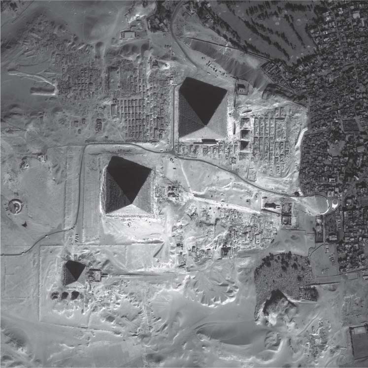
- Pattern: The three main objects are arranged in a definite diagonal line.
- Texture: The area around the three objects is of very fine texture, compared with some of the rougher textures nearby, especially in the east.
- Tone: The area around the three objects is much lighter than the area of rougher texture (and that area’s probably a town or city of some sort, given the pattern of the objects in this range). Given the tone and texture of the ground around the three objects, it’s likely not smooth water or grass or concrete, so sand is a likely choice.
- Site and association: The three objects are located in a large sandy area, adjacent to a city, with what resembles roads leading to the objects.
- Size: Comparing the size of the objects to the size of the buildings indicates that the objects are very large—even the smallest of the three is larger than many buildings, while the largest is greater in size than blocks of the city.
- Shadow: The shadows cast by the objects indicate that not only are they tall, but they have a distinctive pointed shape at their top.
- Shape: The objects are square at the base, but have pointed, triangular tops, making them pyramid shaped.
Bringing all of these elements of interpretation together, we can find three pyramids of different sizes (although still very large), in a definite fixed arrangement, in sand near a busy city. All of these clues combine to identify the Great Pyramids at Giza, just outside Cairo, Egypt. Aerial images often contain clues that help to identify the objects they contain, or at least to narrow down the options to a handful. Some brief research among collateral material (like groupings of large desert pyramids in that particular arrangement) should nail the identification.
Visual image interpretation skills enable the viewer to discern vital information about the objects in a remotely sensed image. The elements of interpretation can be used to identify (for instance) the specific type of fighter jet on a runway—based on the size and shape of its features, wingspan, engines, and armaments. A forestry expert examining a stand of trees in a remotely sensed image might use visual image interpretation to identify the species of trees in the stand based on the features of the trees.
316