 9.1 Geospatial Lab ApplicationVisual Imagery Interpretation
This chapter’s lab will get you started thinking about what objects look like from the sky rather than the ground. You’ll be examining a series of images, and applying the elements of visual image interpretation we discussed in the chapter—think of it like being a detective and searching the image for clues to help you figure out just what it is you’re looking at. You should be able to figure out exactly what you’re looking at, or at least to narrow down the possibilities to a short list before you turn to support data for help.
Although the items you’ll be examining will all be large and prominent—buildings, or other very visible features—the application of visual image interpretation elements for these simple (and hopefully, fun) examples will help get you started with looking at the world from above.
Objectives
The goals for you to take away from this exercise are:
 to think of how objects look from an aerial perspective.
- to apply the elements of visual image interpretation (as described in the chapter) in order to identify objects in the images.
Using Geospatial Technologies
The concepts you’ll be working with in this lab are used in a variety of real-world applications, including:
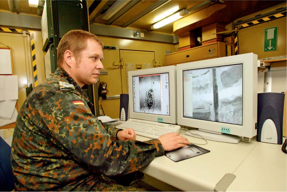
- military intelligence, which relies on knowing the locations of items on the ground—interpretation of objects in aerial reconnaissance photographs is often a key component in planning military operations.
- forest resource management, which utilizes aerial photo interpretation to monitor the health and development of different types of trees by careful observation of foliage and the height and density of the tree canopy.
322
Obtaining Software
There is no special software used in this lab, aside from whatever program your computer uses to view graphics and images. You may find Google Earth useful during the lab, however.
Lab Data
Copy the folder Chapter9—it contains a series of JPEG images (.jpg files) in which you’ll find items that you’ll be attempting to interpret. These are numbered, and tend to increase in difficulty as the numbers go up.
Localizing This Lab
The images used in this lab were taken from a variety of locations around the United States. You can use Google Earth, Google Maps, or Bing Maps to locate good overhead views of nearby areas (showing prominent developed or physical features) to build a dataset of local imagery that you can use for visual image interpretation.
9.1 Applying Elements of Visual Image Interpretation
Take a look at each of the images (there are questions related to each further down), and try to determine just what it is you’re looking at. Although everyone’s application of the elements may vary, there are some guidelines that you may find useful.
Several images may contain multiple items, but all of them work together to help define one key solution.
- We’ll start with a sample image (a digital copy of this sample image is also in the Chapter9 folder labeled “sample”):
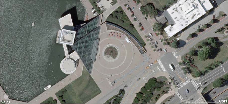 (Source: Bing Map/Microsoft Corporation/Esri)
 - First, look at the image as a whole for items to identify:
- The central object is obviously some sort of structure—and a large one at that, judging from the shadow being cast. The relative size of the structure (when compared with the size of several of the cars visible throughout the image) suggests that it’s probably a building and not a monument of some kind.
- It’s set on a body of water (the tone of the water is different from the tone of the nearby concrete or greenery). Thus, the site can be fixed.
- One of the most notable features is the large triangular shape of the main portion of the building—note too that its texture is very different from the rest of the building (the three white sections).
- The shape of the entranceway is also very distinctive, being large and round, with a couple of concentric circles.
- Second, take the interpretation of the initial items and start looking for specifics, or relationships between the items in the image:
- There’s something about the pattern of those concentric circles at the entrance plaza that’s striking—two outer rings and a third inner ring with some sort of a design placed in it. Judging from the relative size of a person (pick out shadows near the plaza, or on the walkway along the water), the plaza is fairly large. The pattern sort of resembles a giant vinyl record album (and the concept solidifies further with the shape of the large curved feature that follows around the plaza on its right—that looks like the arm of an old record player).
- The texture of the triangular portions of the building suggests that they could be transparent, as if that whole portion of the structure were made of glass.
- There’s no parking lot associated with the building, so you’d have to park somewhere else and walk there. Further, there are no major roads nearby, again indicating that this is not some sort of destination that you just drive up to and park in front. The large body of water gives us a clue that this building is in a large city.
- Third, put the clues together and come up with an idea of what the object or scene could be:
- The building’s distinctive enough to be a monument, but probably too large to be one. It could be some sort of museum, casino, shopping center, or other attraction. However, the building’s too small to be a casino or resort center, and lacks the necessary parking to be a casino, office, or shopping center.
- The very distinct “record” motif of the front plaza seems to indicate that music (and more specifically older music, given the whole “vinyl record” styling) plays a large part in whatever the building is.
- From the clues in the image, this could be some sort of music museum, like the Rock and Roll Hall of Fame, which is located in Cleveland, Ohio, right on the shore of Lake Erie.
- Fourth and final, use a source to verify your deduction, or to eliminate some potential choices.
- By using Google Earth to search for the Rock and Roll Hall of Fame, the identification will be confirmed. An image search on Google will also turn up some non-aerial pictures of the site to verify your conclusion.
Not all images will be this extensive, and not all may make use of all elements—for instance, there may be one or two items in the image that will help you make a quick identification. However, there are enough clues in each image to figure out what you’re looking at—or to at least narrow the choices down far enough that some research using other sources may be able to lead to a positive identification.
For instance, by putting all of the clues together, you could start searching for large museums dedicated to music—add the triangular glass structures, and the Rock and Roll Hall of Fame will certainly come up.
9.2 Visual Image Interpretation
- To examine an image, open the Chapter9 folder and double-click on the appropriate image (.jpg) file. Whatever program you have on your computer for viewing images should open with the image displayed. You may find it helpful to zoom in on parts of an image as well.
- For each image, answer the questions presented below, then explain which of the elements of visual image interpretation led you to this conclusion, and how they helped you to decide. Writing “shadow and shape helped identify traits of the building” will be unacceptable. However, writing something that answers the question, “What was so special about the shadows in the scene or the shape of items that helped?” will be much better.
- When you identify the items, be very specific (for instance, not just “a baseball stadium,” but “Progressive Field” in Cleveland, Ohio).
Important note: All images used in this exercise are from areas within the United States. - You may want to consult some outside sources for extra information, such as Websites, search engines, books, or maps. Lastly, when you finally think you have the image properly identified, you may want to use something like Google Earth or Bing Maps to obtain a view of the object in question, to help verify your answer.
Question 9.1
Examine image1. There are several items in this image, but there’s one that’s more prominent than the others. What, specifically, is this item? What elements of visual image interpretation lead you to this conclusion?
Question 9.2
Examine image2. What (specifically) is being displayed in this image? What elements of visual image interpretation lead you to draw this conclusion?
Question 9.3
Examine image3. What (specifically) is being displayed in this image? What elements of visual image interpretation lead you to draw this conclusion?
Question 9.4
Examine image4. There are several items in this image, but there’s one that’s more prominent than the others. What, specifically, is this item? What elements of visual image interpretation lead you to draw this conclusion?
Question 9.5
Examine image5. There are many similar objects in this image, but you’ll notice some differences too. What (specifically) is being displayed in this image, and what is its location? What elements of visual image interpretation lead you to draw this conclusion?
Question 9.6
Examine image6. There are several items in this image, but they all add up to one specific thing. What, specifically, is this image showing, and what is its location? What elements of visual image interpretation lead you to draw this conclusion?
Question 9.7
Examine image7. What (specifically) is being displayed in this image? What elements of visual image interpretation lead you to draw this conclusion?
Question 9.8
Examine image8. There are several items in this image, but they all add up to one specific thing. What, specifically, is this image showing (and what is its geographic location)? What elements of visual image interpretation lead you to draw this conclusion?
326
Question 9.9
Examine image9. What feature is prominent in the image? Be specific as to what the area is and what geographic location is being shown here. What elements of visual image interpretation lead you to this conclusion? What are all those white objects throughout the image (and how do they help identify the area)?
Question 9.10
Examine image10. What feature is prominent in the image? Be specific as to what the object is and what geographic location is being shown here. What elements of visual image interpretation lead you to this conclusion? Several airplanes are very clearly visible—how do they help identify the feature?
Closing Time
Now that you’ve gotten your feet wet with some visual image interpretation and have hopefully gotten used to viewing Earth from above, Chapter 10 will delve into satellite imagery, and its exercise will have you doing (among other things) some more interpretation tasks based on satellite capabilities.
Once you’ve identified all of the images and explained your application of the elements of image interpretation, you can close the Chapter9 folder and any other programs or resources you have open.