5-3 Volcanoes and earthquakes reveal energy from a molten interior driving Earth’s surface to shift positions
Looking out the window, you might wonder if Earth looks more or less the same today as it always has. Trees and buildings come and go, but what about major landforms such as mountains and oceans? And if something as massive as a mountain could change, what force of nature is strong enough to accomplish such a task? Earth is full of energy. Some of that energy is left over from the force of impacts in the early formation of our planet, a time when the planet was completely molten. But the majority of Earth’s internal energy comes from radioactive decay of elements such as uranium, thorium, and potassium deep inside Earth. This energy drives geologic activity that profoundly affects Earth’s surface. How do we actually know what is at the center of Earth? Surprisingly, our search starts with the rocks just under our feet.
An Iron-Rich Planet
The specific kinds of rocks found on and near Earth’s surface provide important clues to our planet’s interior. The densities of typical surface rocks are around 3000 kg/m3, but the average density of Earth as a whole is 5515 kg/m3. (As you saw in Chapter 4, average density is total mass divided by total volume.) The interior of Earth must therefore be composed of substances much denser than those found near the surface. But what is this substance? Why is Earth’s interior denser than its crust? And is Earth’s interior solid like rock or molten like magma?
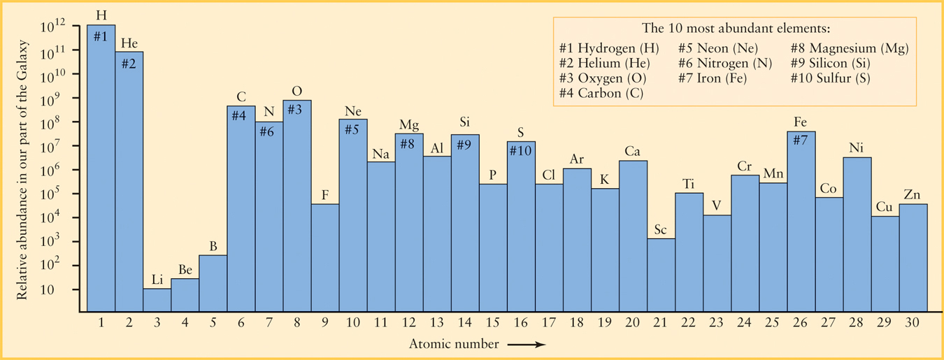
Iron (chemical symbol Fe) is a good candidate for the substance that makes up most of Earth’s interior for two reasons. First, iron atoms are quite massive—a typical iron atom has 56 times the mass of a hydrogen atom—and second, iron is relatively abundant. Figure 5-9 shows that it is the seventh most abundant element in our part of the Milky Way Galaxy. Other elements such as lead and uranium have more massive atoms, but these elements are quite rare—they would be ranked by their atomic numbers at 82 and 92, respectively, if Figure 5-9 was extended to the right. Hence, the solar nebula could not have had enough of these massive atoms to create Earth’s dense interior. Furthermore, iron is common in meteoroids that strike Earth, which suggests that it was abundant in the planetesimals from which Earth formed.
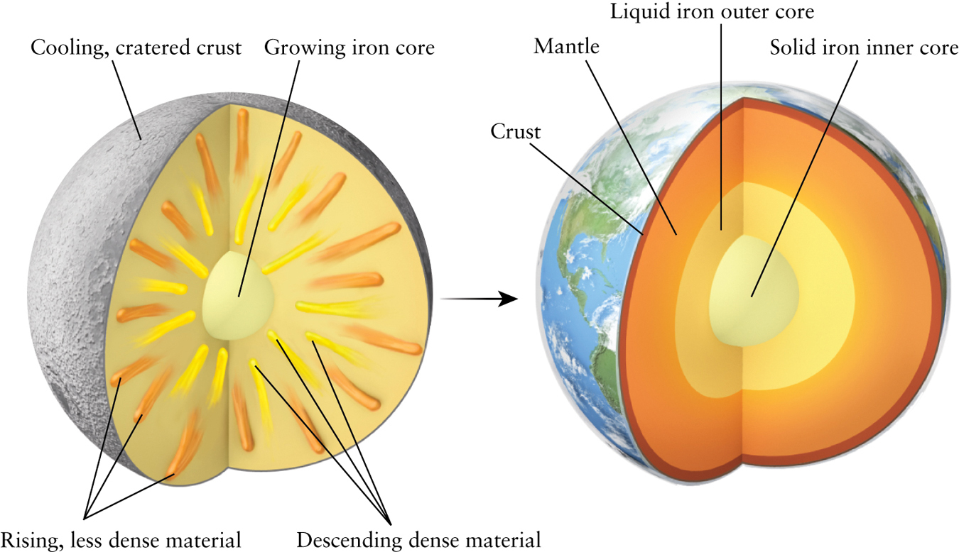
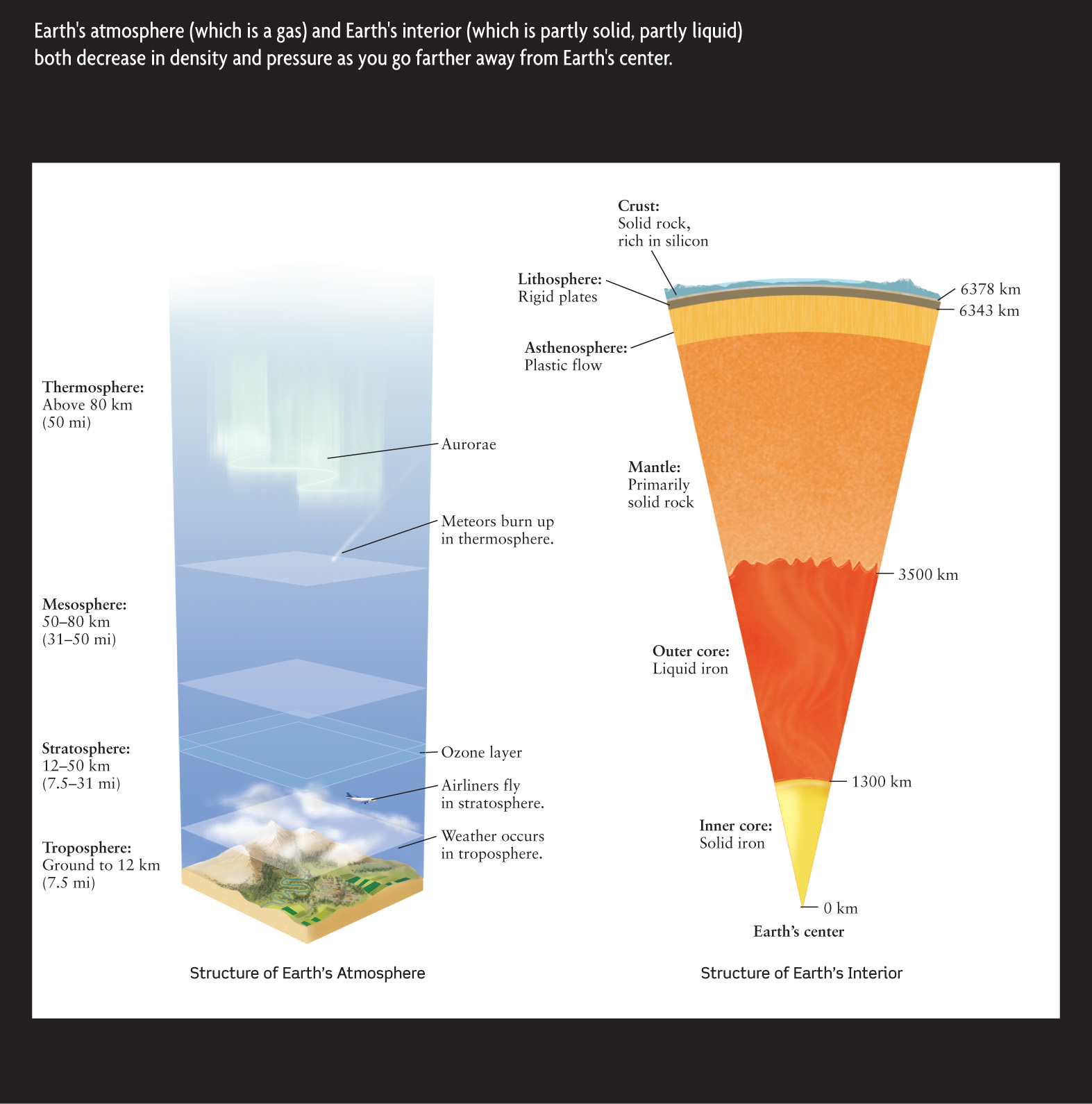
Earth was almost certainly molten soon after its formation, about 4.56 × 10⁹ years ago. Energy released by the violent impacts of numerous meteoroids and asteroids and by the decay of radioactive material likely melted the solid parts collected from the earlier planetesimals. Gravity caused the abundant, dense iron to sink toward Earth’s center, forcing less dense material upward to the surface. Figure 5-10a shows this process of differentiation. This is the same process that happens when Italian salad dressing separates into various layers when left undisturbed for a time. In much the same way, we end up with a planet with the layered structure shown in Figure 5-10b—a central core composed almost entirely of iron, surrounded by a mantle of dense, iron-enriched rocks made from silicon and oxygen. The mantle, in turn, is surrounded by an extremely thin crust of relatively light silicon-rich minerals. We live on the surface of this crust. See Cosmic Connections: Comparing Earth’s Atmosphere and Interior for more information.
123
Question
ConceptCheck 5-7: If a new, Earth-sized planet was discovered that had surface rocks nearly identical to Earth but a much lower average density, what might a scientist assume about iron in its interior?
Earthquake Waves as Earth Probes
 Go to Video 5-2
How might we confirm that Earth does in fact have a layered structure? The challenge in directly testing this notion is that Earth’s interior is inaccessible. The deepest wells go down only a few kilometers, barely penetrating the surface of our planet. Despite these difficulties, geologists have learned basic properties of Earth’s interior by studying earthquakes and the waves they produce.
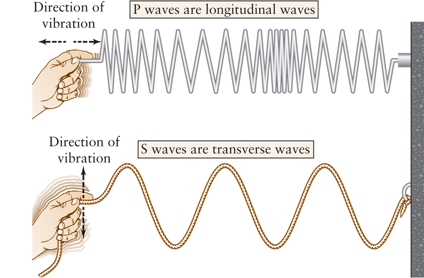
Over the centuries, stresses build up in Earth’s crust. Occasionally, these stresses are relieved with an energy burst called an earthquake. Most earthquakes occur deep within Earth’s crust. Earthquakes release energy in the form of at least three different kinds of energy waves, which travel around or through Earth in different ways and at different speeds. The first type of wave, which is analogous to water waves on the ocean, causes the rolling motion that people feel near the source of an earthquake. These are called surface waves because they travel only over Earth’s surface and can cause a tremendous amount of destruction. The two other kinds of waves, called P waves (the P is for “primary”) and S waves (the capital S is for “secondary,” not for the s in “surface” waves, which are sometimes confusingly designated with an L), travel through the interior of Earth. P waves are called longitudinal waves because their oscillations are in the same direction the energy wave travels, like a spring that is alternately pushed and pulled. In contrast, S waves are called transverse waves because their vibrations are perpendicular to the direction in which the energy waves move. S waves are analogous to waves produced by a person shaking a rope up and down (Figure 5-11).
What makes earthquake waves useful for learning about Earth’s interior is that they do not travel in straight lines. Instead, the paths that they follow through the body of Earth are bent because of the varying density and composition of Earth’s interior. Just as light waves bend when they pass from air into glass or vice versa, earthquake waves bend as they pass through different parts of Earth’s interior. By studying how the paths of these waves bend, geologists can map out the general interior structure of Earth.
124
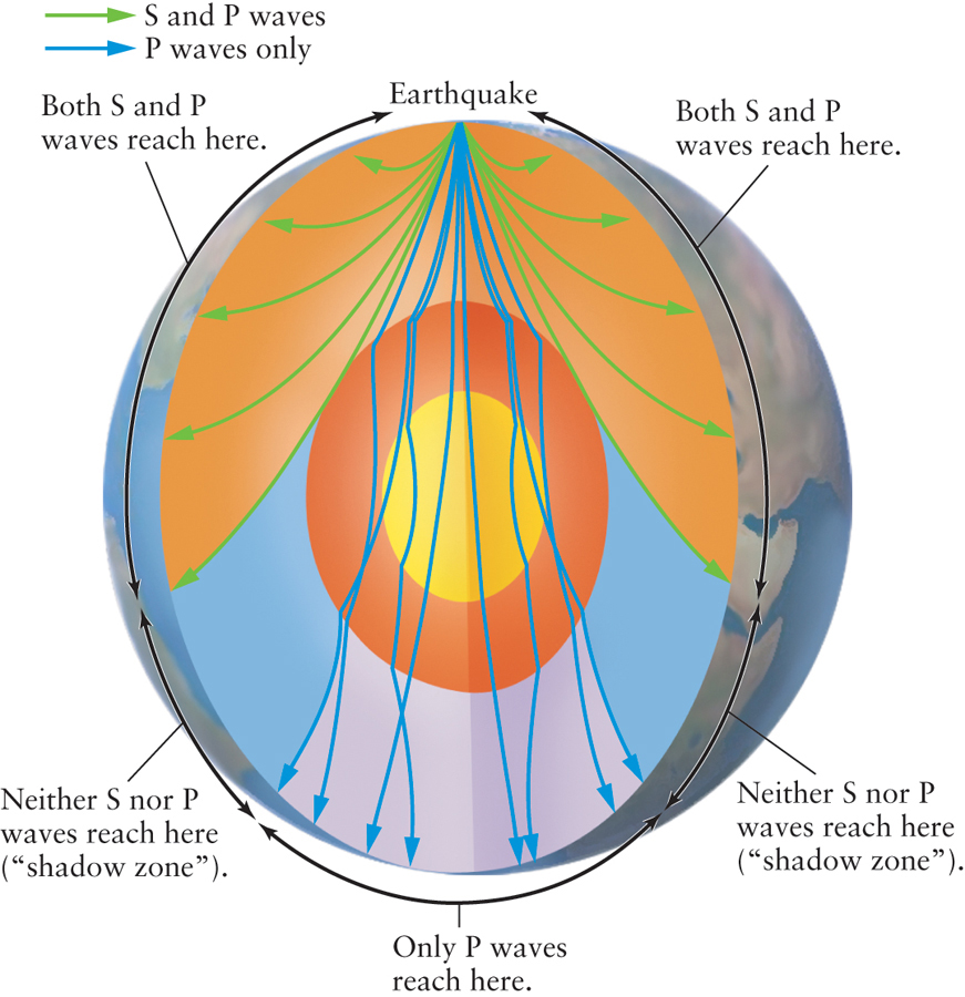
One key observation about earthquake waves and how they bend has to do with the differences between S and P waves. When an earthquake occurs and releases energy, both S and P waves are observed near the center of the earthquake, but geologists on the opposite side of Earth observe only P waves. The absence of S waves was first explained in 1906 by the British geologist Richard Dixon Oldham, who noted that transverse vibrations such as S waves cannot travel far through liquids. Oldham therefore concluded that our planet has a molten core. Furthermore, there is a region in which neither S waves nor P waves from an earthquake can be detected (Figure 5-12). This “shadow zone” results from the specific way in which P waves are refracted at the boundary between the solid mantle and the molten core. By measuring the size of the shadow zone, geologists have concluded that the radius of the molten core is about 2200 mi (3500 km), about 55% of our planet’s overall radius but about double the radius of the Moon (1080 mi = 1738 km). In 1936, the Danish geologist Inge Lehmann explained that the rare P wave that did successfully pass through Earth is deflected into the shadow zone by a small, solid inner core at the center of our planet. The radius of this inner core is about 800 mi (1300 km).
Question
ConceptCheck 5-8: What would have changed about Earth’s interior if S waves from earthquakes suddenly started being observed on the side of Earth opposite an earthquake?
Earth’s Major Layers
The earthquake evidence reveals that our planet has a curious internal structure—a liquid outer core sandwiched between a solid inner core and a mostly solid mantle. Table 5-1 summarizes this structure. To understand this arrangement, we must look at how temperature and pressure inside Earth affect the melting point of rock.
| Region | Depth below surface (km) | Distance from center (km) | Average density (kg/m2) |
|---|---|---|---|
| Crust (solid) | 0–5 (under oceans), 0–35 (under continents) | 6343–6378 | 3500 |
| Mantle (plastic, solid) | from bottom of crust to 2900 | 3500–6343 | 3500–5500 |
| Outer core (liquid) | 2900–5100 | 1300–3500 | 10,000–12,000 |
| Inner core (solid) | 5100–6400 | 0–1300 | 13,000 |
Both temperature and pressure increase with increasing depth below Earth’s surface. The temperature of Earth’s interior rises steadily from about 14°C on the surface to nearly 5000°C at our planet’s center (Figure 5-13).
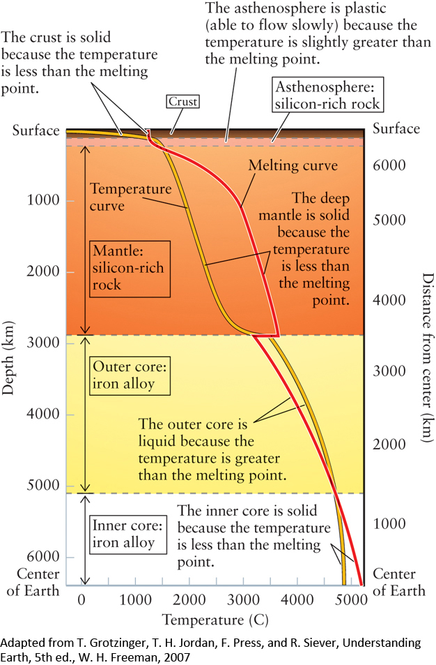
Earth’s outermost layer, the crust, varies quite a bit in thickness, but overall is only about 3 mi to 20 mi (5 km to 35 km) thick. Given the enormous size of Earth, the crust is an extremely thin layer. It is composed of rocks with a melting temperature far higher than the temperatures actually found in the crust. Thus, the crust is solid.
Earth’s mantle, which extends to a depth of about 1800 mi (2900 km), is largely composed of substances enriched by iron and magnesium. On Earth’s surface, specimens of these substances will melt at slightly over 1000°C. However, the temperature at which rock melts depends on the pressure to which it is subjected—the higher the pressure, the higher the melting temperature. As Figure 5-13 shows, the actual temperatures throughout most of the mantle are less than the melting temperature of all the substances of which the mantle is made. Hence, the mantle is primarily solid. However, the upper levels of the mantle—called the asthenosphere (from the Greek asthenia, meaning “weakness”)—are able to flow slowly and are therefore often referred to as being somewhat “plastic.”
125
CAUTION
It may seem strange to think of a plastic material as one that is able to flow. Normally, we think of plastic objects as being hard and solid, like the plastic out of which compact discs and soft drink bottles are made. But to make these objects, the plastic material is heated so that it can flow into a mold, and then cooled so that it solidifies. Strictly, the material is only “plastic” when it is able to flow. Maple syrup and tree sap are two other substances that flow at warm temperatures but become solid when cooled.
At the boundary between the mantle and the outer core, there is an abrupt change in chemical composition, from silicon-rich materials to almost-pure iron with a small mix of nickel. Because this iron has a lower melting point than the material above it, the melting curve in Figure 5-13 has a “jog” as it crosses from the mantle to the outer core and remains. As a result, the temperature at which rocks melt here is somewhat less than the temperature at depths of about 1800 mi to 3200 mi (2900 km to 5100 km), and the outer core is liquid.
At depths greater than about 3000 mi (5100 km), the pressure is more than 106 times ordinary atmospheric pressure, or about 104 tons per square inch. Because the melting temperature of the iron-nickel mixture under this pressure is higher than the actual temperature (see Figure 5-13), Earth’s inner core is solid.
Heat naturally flows from where the temperature is high to where it is low. Figure 5-13 thus explains why there is a heat flow from the center of Earth outward. We will see in the next section how this heat flow acts as the “engine” that powers our planet’s geologic activity.
Question
ConceptCheck 5-9: How would the temperature at which rocks melt be different inside a much larger and denser planet where the internal pressure is higher?
Plate Tectonics
When looking at the shape of the ocean between the continents of Africa and South America (Figure 5-14), one naturally wonders if the two continents were closer together in the past. What evidence would you need to be convinced that the two were at one time closer together and that the continents are still moving? What would you think if there were similar fossils on both sides of the Atlantic Ocean? What would you think if you could take GPS satellite measurements and see the two moving apart? Indeed, this is exactly what we observe—the Atlantic Ocean is widening.
Close inspection of Earth’s landforms, both above and beneath the oceans, reveal that Earth’s crust is divided into huge plates whose motions produce earthquakes, volcanoes, mountain ranges, and oceanic trenches. This picture of Earth’s crust, now known as plate tectonics (from the Greek tekton, meaning “builder”), has come to be the central unifying theory of geology, much as the theory of evolution has become the centerpiece of modern biology.
126
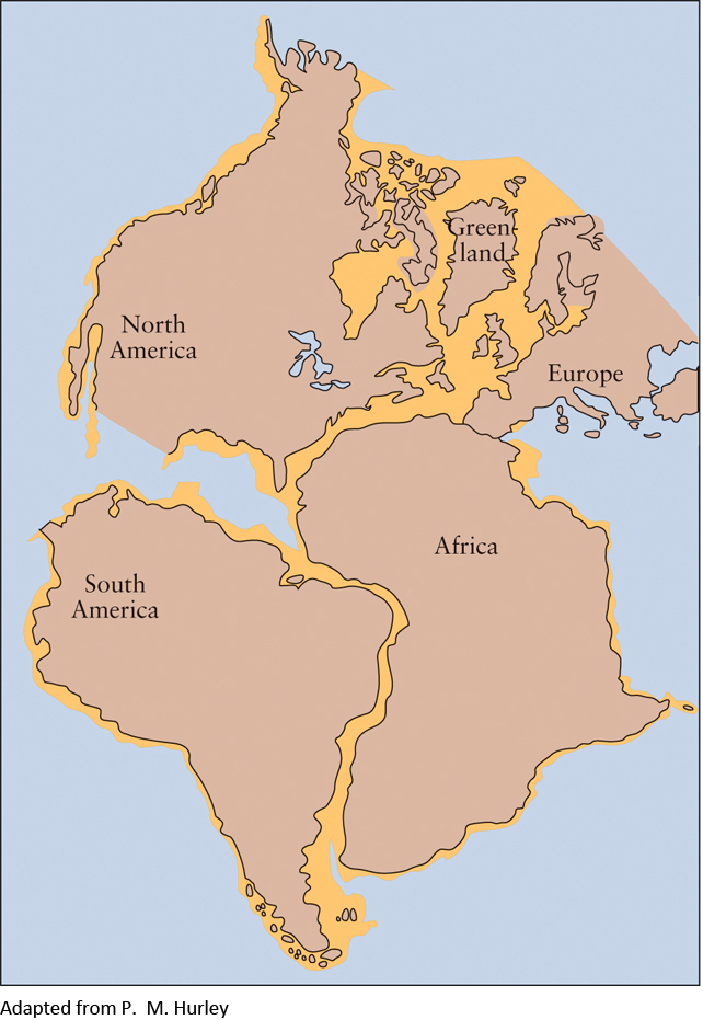
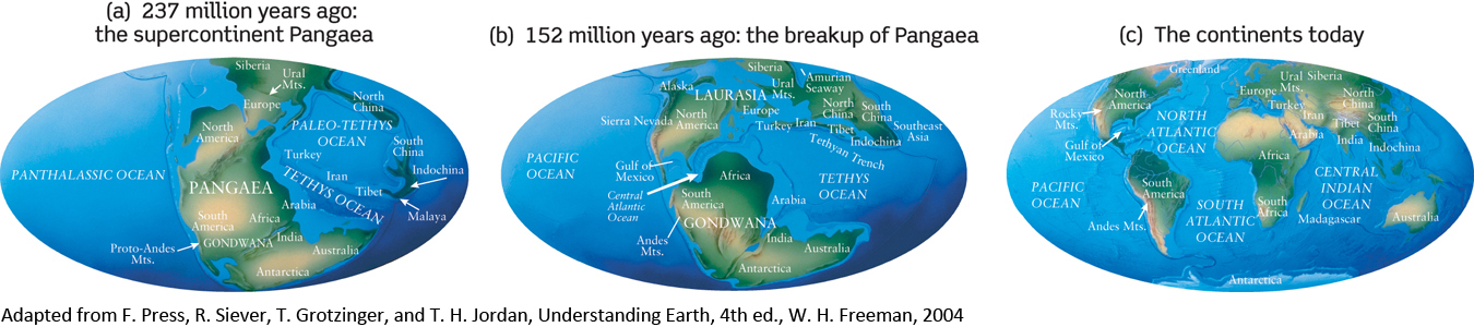
Based on the apparent fit of the continents, the German meteorologist Alfred Wegener advocated “continental drift”—the idea that the continents on either side of the Atlantic Ocean have simply drifted apart. In 1915 he published the theory that there had originally been a single gigantic supercontinent, which he called Pangaea (meaning “all lands”). Based on how fast South America and Africa are separating today, this separation probably began roughly 200 million years ago, during what geologists refer to as the early Jurassic period, when dinosaurs dominated the land.
Over time, geologists have refined this theory, arguing that Pangaea must have first split into two smaller supercontinents, which they called Laurasia and Gondwana, separated by what they called the Tethys Ocean. Gondwana later split into Africa and South America, with Laurasia dividing to become North America and Eurasia. According to this theory, the Mediterranean Sea is a surviving remnant of the ancient Tethys Ocean (Figure 5-15).
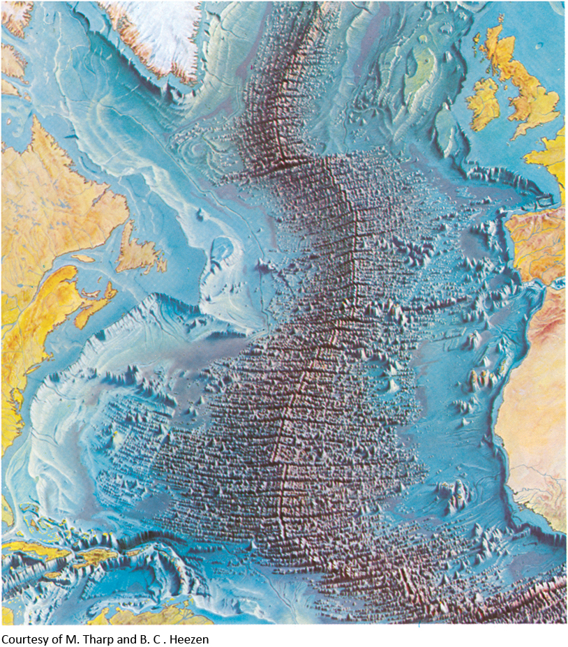
The actual mechanism that was driving the continents’ motions was not evident until the mid-1950s, when geologists discovered that material is being forced upward to the crust from deep within Earth. Bruce C. Heezen of Columbia University and his colleagues began discovering long mountain ranges on the ocean floors, such as the Mid-Atlantic Ridge, which stretches all the way from Iceland to Antarctica (Figure 5-16). During the 1960s, Harry Hess of Princeton University and Robert Dietz of the University of California carefully examined the floor of the Atlantic Ocean. They concluded that rock from Earth’s mantle is being melted and then forced upward along the Mid-Atlantic Ridge, which is in essence a long chain of underwater volcanoes.
The upwelling of new material from the mantle to the crust forces the existing crust to separate, causing seafloor spreading. For example, the floor of the Atlantic Ocean to the east of the Mid-Atlantic Ridge is moving east-ward and the floor to the west is moving westward. By explaining what fills in the gap between continents as they move apart, seafloor spreading helps to fill out the theories of continental drift. Because of the seafloor spreading from the Mid- Atlantic Ridge, South America and Africa are moving apart at a speed of roughly 3 cm per year. Working backward, these two continents would have been next to each other some 200 million years ago (see Figure 5-14).
Question
ConceptCheck 5-10: Does seafloor spreading result in an underwater mountain range or a deep canyon?
Question
CalculationCheck 5-1: If seafloor spreading was occurring at only 2 cm per year, how long would it have taken for the Atlantic to open to its current width of 600 million (6 × 10⁸) cm?
127
Convection and Plate Motion
What makes plates move? The high temperatures within Earth cause energy in the form of heat to flow outward from Earth’s hot core to its cool crust. Hot material deep in Earth is less dense than cooler material farther away from the core and tends to rise, much the same way heated air in a giant hot air balloon will rise high above Earth’s surface. As hot mantle material rises, it transfers heat to its surroundings. As a result, the rising material cools and becomes denser. It then sinks downward to be heated again, and the process starts over. Earlier in this chapter, we considered convection cycles that occur in a boiling pot of water (Figure 5-6), which also occur in the atmosphere. Here, too, we find that convection occurs when warmer parts of the partially molten mantle, heated from below, slowly rise. The heat that drives convection in Earth’s outer layers actually comes from very far below, at the boundary between the outer and inner cores. As material deep in the liquid core cools and solidifies to join the solid portion of the core, it releases the energy needed to heat the overlying mantle and cause convection.
CAUTION
When thinking about the circular pattern that boiling water follows on a kitchen stove, you might be inclined to think that this only occurs with liquids, like water. On the stove, water near the bottom of the heated pan expands and drifts upward because it is now less dense than the cooler water around it. The cooler water on top is pushed out of the way by the rising warmer water, and the cooler water moves to the bottom where it is heated, and the cycle starts over again. It might surprise you, however, to know that convection cycles can happen with any substance that expands when heated. When we talked about atmospheres, we noted that this can happen with gases, just like it can with liquid. It happens when a candle burns because rising air is consumed by the fire and cooler air nearby takes its place. Inside Earth, when heated plastic-like material in the mantle close to the hot core is heated, it expands and begins to rise, pushing the cooler, less dense mantle material out of the way, just like we saw with liquids and with gas.
The upper level of the mantle, the asthenosphere, is hot and soft enough to permit an oozing, plastic flow. Atop the asthenosphere is a rigid layer, called the lithosphere (from the Greek word for “rock”). The lithosphere is divided into plates that ride along the convection currents of the asthenosphere. Earth’s crust is simply the uppermost layer of the lithosphere, with a somewhat different chemical composition than the lithosphere’s lower regions.
Figure 5-17 shows how convection causes plate movement. Molten subsurface rock seeps upward along oceanic rifts, where plates are separating. The Mid-Atlantic Ridge, shown in Figure 5-16, is an oceanic rift and seafloor spreading is occurring there. Where plates collide, cool crustal material from one of the plates sinks back down into the mantle along a subduction zone. One such subduction zone is found along the west coast of South America, where the oceanic Nazca plate is being subducted into the mantle under the continental South American plate at a relatively speedy 10 cm per year. As the material from the subducted plate sinks, it pulls the rest of its plate along with it, thus helping to keep the plates in motion. New material is added to the crust from the mantle at the oceanic rifts and is “recycled” back into the mantle at the subduction zones. In this way the total amount of crust remains essentially the same.
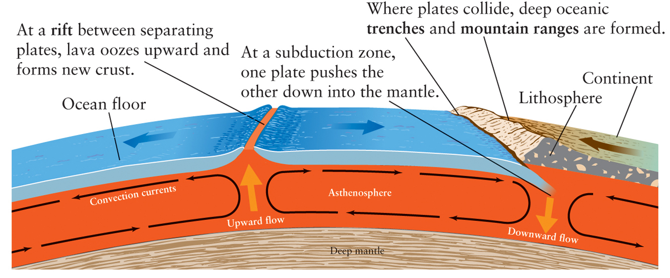
Convection cycles in Earth’s upper mantle drag Earth’s plates around so that they separate, collide, and grind against each other.
Geologists today realize that earthquakes, and the vast majority of volcanoes, tend to occur at the boundaries of Earth’s crustal plates, where the plates are colliding, separating, or rubbing against each other. The boundaries of the plates therefore stand out clearly when earthquake locations are plotted on a map as in Figure 5-18.
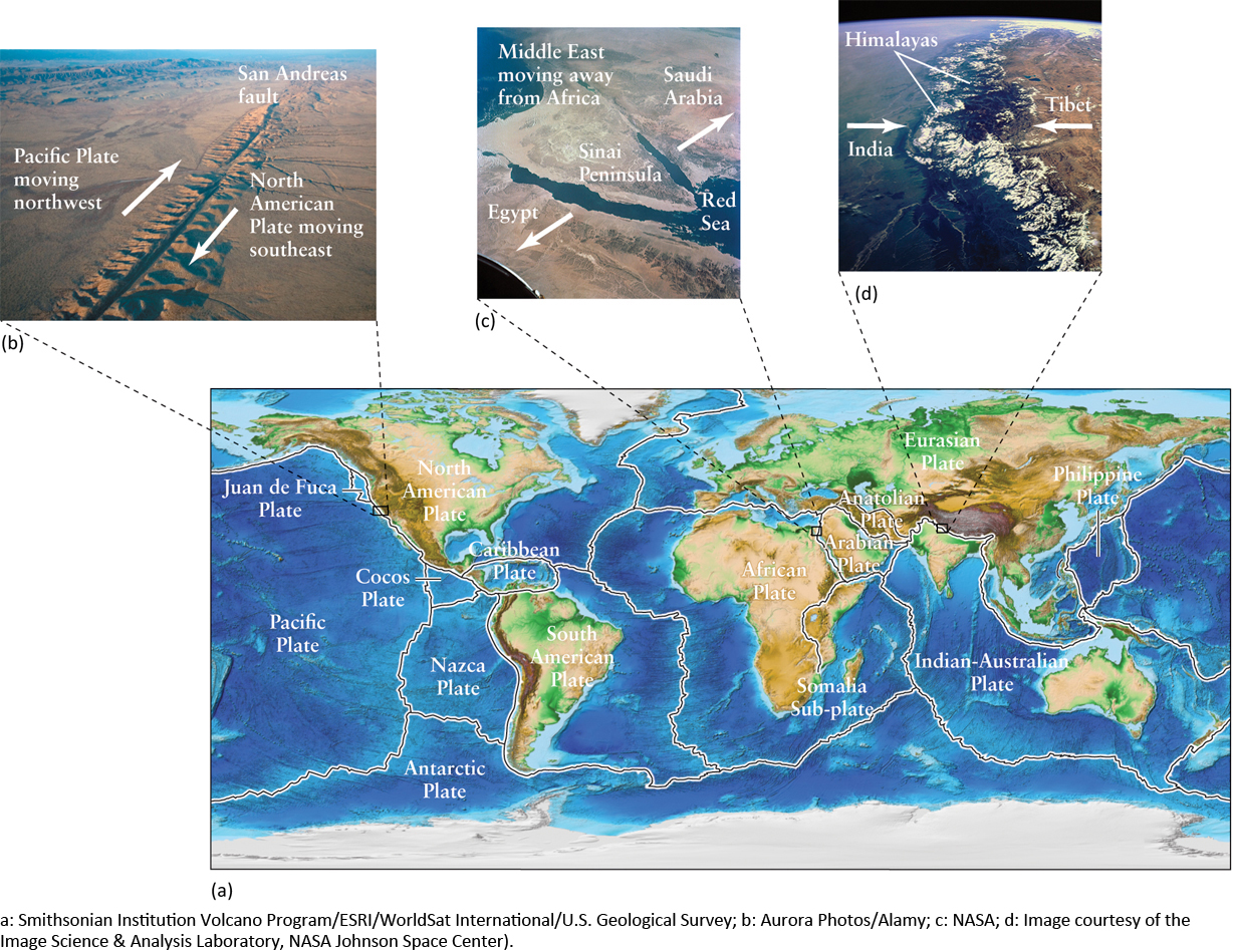
The boundaries between plates are the sites of some of the most impressive geological activity on our planet. Great mountain ranges, such as the Sierras and Cascades along the western coast of North America and the Andes along South America’s west coast, are thrust up by ongoing collisions between continental plates and the plates of the ocean floor. Subduction zones, where old crust is drawn back down into the mantle, are typically the locations of deep oceanic trenches, such as the Peru-Chile Trench off the west coast of South America. Figures 5-18b, c, and d show three well-known geographic features that resulted from tectonic activity at plate boundaries.
Question
ConceptCheck 5-11: What becomes of the material from the oceanic crust when it is subducted beneath continental crust?
The Cycle of Supercontinents
Plate tectonic theory offers insight into geology on the largest of scales, that of an entire supercontinent. In recent years, geologists have uncovered evidence that points to a whole succession of supercontinents that once broke apart and then reassembled. Pangaea is only the most recent supercontinent in this cycle, which repeats about every 500 million (5 × 10⁸) years. As a result, intense episodes of mountain building have occurred at roughly 500-million-year intervals.
128
Apparently, a supercontinent sows the seeds of its own destruction because it blocks the flow of heat from Earth’s interior. As soon as a supercontinent forms, temperatures beneath it rise, much as they do under a book lying on an electric blanket. As heat accumulates, the lithosphere domes upward and cracks. Molten rock from the overheated asthenosphere wells up to fill the resulting fractures, which continue to widen as pieces of the fragmenting supercontinent move apart.
It can take a very long time for the heat trapped under a supercontinent to escape. Although Pangaea broke apart some 200 million years ago (see Figure 5-15), the mantle under its former location is still hot and still trying to rise upward. As a result, Africa—which lies close to the center of this mass of rising material—sits several tens of meters higher than the other continents.
The changes wrought by plate tectonics are very slow on the scale of a human lifetime, but they are very rapid in comparison with the age of Earth. For example, the period over which Pangaea broke into Laurasia and Gondwana was only about 0.4% of Earth’s age of 4.56 × 10⁹ years. (To put this in perspective, 0.4% of an average human lifetime is about 4 months.) The lesson of plate tectonics is that the seemingly permanent face of Earth is in fact dynamic and ever-changing.
Question
ConceptCheck 5-12: What causes a supercontinent to break apart?
Question
CalculationCheck 5-2: If supercontinents are formed and break up in a 500-million-year cycle, about how many supercontinents could come and go over Earth’s roughly 5-billion-year existence?
129
COSMIC CONNECTIONS Comparing Earth’s Atmosphere and Interior
130