The Global Pattern of Volcanism
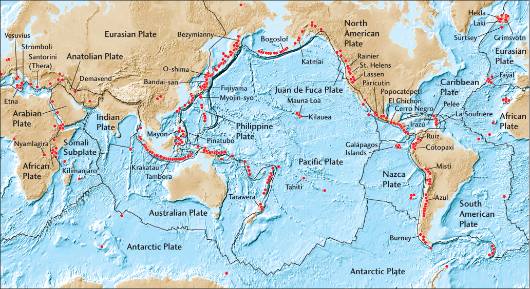
Before the advent of plate tectonic theory, geologists noted a concentration of volcanoes around the rim of the Pacific Ocean and nicknamed it the Ring of Fire (see Figure 2.6). The explanation of the Ring of Fire in terms of subduction zones was one of the great successes of the new theory. As we will see in this section, plate tectonics can explain essentially all major features in the global pattern of volcanism (Figure 12.24).
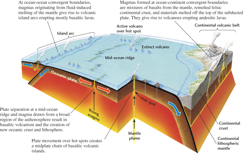
Figure 12.25 shows the locations of the world’s active volcanoes that occur on land or above the ocean surface. About 80 percent are found at convergent plate boundaries, 15 percent at divergent plate boundaries, and the remaining few within plate interiors. There are many more active volcanoes than shown on this map, however. Most of the lava erupted on Earth’s surface comes from vents beneath the oceans, located at spreading centers on mid-ocean ridges.
330
Volcanism at Spreading Centers
As we have seen, enormous volumes of basaltic lava erupt continually along the global network of mid-ocean ridges—enough to have created all of the present-day seafloor. This “crustal factory” lies beneath a rift valley a few kilometers wide, and it extends along the thousands of kilometers of mid-ocean ridges (see Figure 12.24). The erupted magma is formed by decompression melting of mantle peridotite, as described in Chapter 4.
Divergent boundaries comprise segments of a mid-ocean ridge offset in a zigzag pattern by transform faults (see Figure 2.7). Detailed geologic mapping of the seafloor has revealed that the ridge segments can themselves be quite complex. They are often composed of shorter, parallel spreading centers that are offset by a few kilometers and may partly overlap. Each of these spreading centers is an “axial volcano” that erupts basaltic lava at variable rates along its length. Basalts from nearby axial volcanoes often show slight geochemical differences, indicating that the axial volcanoes have separate plumbing systems.
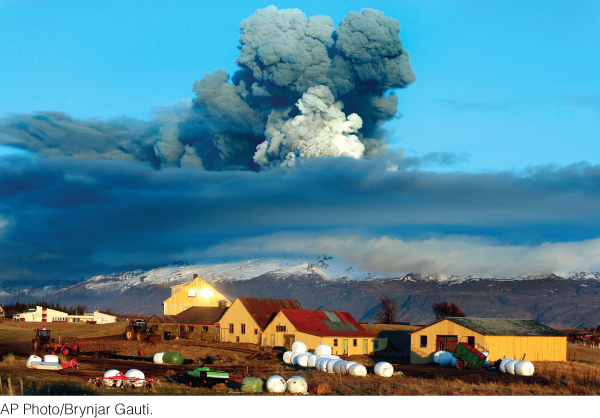
In Iceland, the Mid-Atlantic Ridge rises above the ocean, and large basaltic eruptions are common. The most recent major eruption, from a volcano beneath the Eyjafjallajökull ice cap on the southern coast of Iceland in 2010, ejected massive amounts of very fine-grained ash high into the atmosphere, which disrupted air traffic across western Europe for many weeks (see Earth Issues 12.1).
Volcanism in Subduction Zones
One of the most striking features of a subduction zone is the chain of volcanic mountains that parallels the convergent boundary above the sinking slab of oceanic lithosphere, regardless of whether the overriding lithosphere is oceanic or continental (see Figure 12.24). The magmas that feed subduction-zone volcanoes are produced by fluid-induced melting (see Chapter 4) and are more varied in their chemical composition than the basaltic magmas produced at mid-ocean ridges. They range from mafic to felsic—that is, from basaltic to rhyolitic—although intermediate (andesitic) compositions are the most common observed on land.
Where the overriding lithosphere is oceanic, subduction-zone volcanoes form volcanic island arcs, such as the Aleutian Islands of Alaska and the Mariana Islands of the western Pacific. Where oceanic lithosphere is subducted beneath a continent, the volcanoes and volcanic rocks coalesce to form a volcanic mountain belt on land, such as the Andes, which mark the subduction of the oceanic Nazca Plate beneath continental South America.
331
12.1 Volcanic Ash Clouds over Europe
On April 14, 2010, Eyjafjallajökull volcano in Iceland began a series of eruptions that shut down air travel over western and northern Europe for a period of six days. [According to the joke, “Eyjafjallajökull” is Icelandic for “name that no one can pronounce” Actually, it’s pronounced: aye-ya-fyah-dla-jow-kudl and means “island-mountain glacier.”] These eruptions led to the closure of most of Europe’s larger airports with caused the cancelation of many flights to and from Europe, resulting in the highest level of air traffic disruption since World War II. Many people were stranded for days with little comfort as flights were sequentially canceled, leaving people to struggle to find alternative means of transportation or accommodations. In the week following the eruption it is estimated that 250,000 British, French and Irish citizens were stranded abroad, the European economy may have lost almost 2 billion dollars, and the aviation industry lost up to 250 million dollars per day.
The eruptions were predicted well in advance. Seismic activity in and around Eyjafjallajökull began in late 2009 and increased in intensity and frequency until March 20, 2010, when a small eruption occurred. A second, much larger eruption occurred on April 14th ejecting 250 million cubic meters of volcanic ash. The ash cloud rose to elevations of 9,000 meters and, though not as large as the 1980 Mount St. Helens eruption in Oregon, it was high enough to enter the jet stream, which flowed directly over Iceland at the time. The westward flow of the jet stream transported the ash to Europe where it spread out over a large part of the continent.
Much of this volcanic ash was produced by the interaction of hot magma with glacial ice and water, which made it very fined grained, less than 2 mm in size. When ash of this size gets caught up in jet engines, the high temperatures of the jet (up to 2000ºC) can remelt it, recreating a sticky lava that can cause engine failure. In extreme cases, planes have had to literally glide their way out of the ash cloud before engines can be restarted.
The Eyjafjallajökull eruptions lasted for only one month; by June, 2010, very little ash was being ejected. But future eruptions in Iceland are inevitable, and the agricultural and environmental consequences for Europe are potentially dire. Right now, geologists are carefully monitoring the nearby Katla volcano, whose historical eruptions have often followed those of Eyjafjallajökull. In the long term.
The terrain of Japan is a prime example of the complex of intrusive and extrusive igneous rock that may evolve over many millions of years at a subduction zone. Everywhere in this small country are all kinds of extrusive igneous rocks of various ages, mixed in with mafic and intermediate intrusives, metamorphosed volcanic rocks, and sedimentary rocks derived from erosion of the igneous rocks. The erosion of these various rocks has contributed to the distinctive landscapes portrayed in so many classic and modern Japanese paintings.
Intraplate Volcanism: The Mantle Plume Hypothesis
Decompression melting explains volcanism at spreading centers, and fluid-induced melting can account for the volcanism above subduction zones, but how can plate tectonic theory explain intraplate volcanism—that is, volcanoes far from plate boundaries? Geologists have found a clue in the ages of such volcanoes.
Hot Spots and Mantle Plumes
Consider the Hawaiian Islands, which stretch across the middle of the Pacific Plate. This island chain begins with the active volcanoes on the island of Hawaii and continues to the northwest as a string of progressively older, extinct, eroded, and submerged volcanic mountains and ridges. In contrast to the seismically active mid-ocean ridges, the Hawaiian island chain is not marked by frequent large earthquakes (except near the active volcanoes). It is essentially aseismic (without earthquakes), and is therefore called an aseismic ridge. Active volcanoes at the beginnings of progressively older aseismic ridges can be found elsewhere in the Pacific and in other large ocean basins. Two examples are the active volcanoes of Tahiti, at the southeastern end of the Society Islands, and the Galápagos Islands, at the western end of the aseismic Nazca Ridge (see Figure 12.25).
332
Once the general pattern of plate movements had been worked out, geologists were able to show that these aseismic ridges approximated the paths that the plates would take over a set of volcanically active hot spots that were fixed relative to one another, as if they were blowtorches anchored in Earth’s mantle (Figure 12.26). Based on this evidence, they hypothesized that hot spots were caused by hot, solid material rising in narrow, cylindrical jets from deep within the mantle (perhaps as deep as the core-mantle boundary), called mantle plumes. According to the mantle plume hypothesis, when peridotites transported upward in a mantle plume reach lower pressures at shallower depths, they begin to melt, producing basaltic magma. The magma penetrates the lithosphere and erupts at the surface. The current position of a plate over the hot spot is marked by an active volcano, which becomes inactive as plate movement carries it away from the hot spot. The movement of the plate thus generates a trail of extinct, progressively older volcanoes. As shown in Figure 12.26a, the Hawaiian Islands fit this pattern well. Dating of the volcanoes yields a rate of movement of the Pacific Plate over the Hawaiian hot spot of about 100 mm/year.
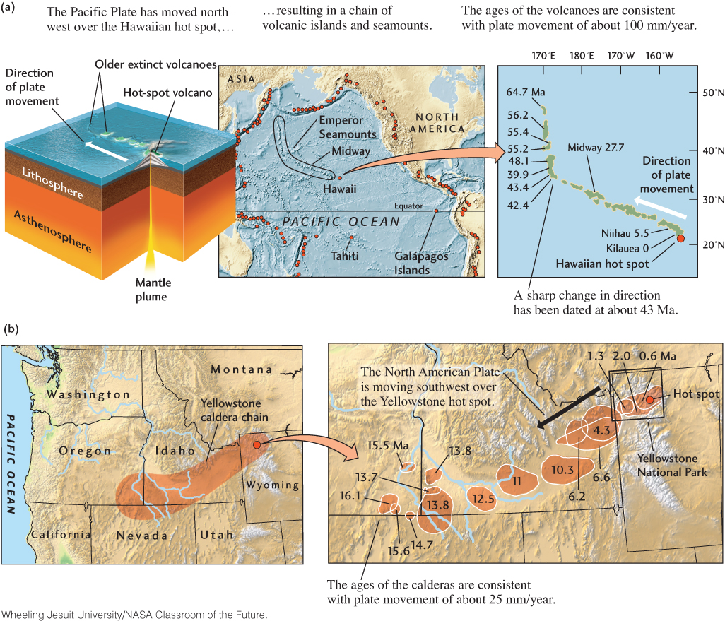
Some aspects of intraplate volcanism within continents can also been explained by the mantle plume hypothesis. The modern Yellowstone caldera, only 630,000 years old, is still volcanically active, as evidenced by the geysers, hot springs, uplift, and earthquakes observed in the area. It is the youngest member of a chain of sequentially older and now-extinct calderas that supposedly mark the movement of the North American Plate over the Yellowstone hot spot (Figure 12.26b). The oldest member of the chain, a volcanic area in Oregon, erupted about 16 million years ago, producing some of the flood basalts of the Columbia Plateau. The North American Plate has moved over the Yellowstone hot spot to the southwest at a rate of about 25 mm/year during the past 16 million years. Accounting for the relative movement of the Pacific and North American plates, this rate and direction are consistent with the plate movements inferred from the Hawaiian Islands.
333
Measuring Plate Movements Using Hotspot Tracks
Assuming that hot spots are anchored by plumes rising from the deep mantle, geologists can use the worldwide distribution of their volcanic tracks to compute how the global system of plates is moving with respect to the deep mantle. The results are sometimes called “absolute plate movements” to distinguish them from the movements of plates relative to each other. The absolute plate movements calculated from hot-spot tracks have helped geologists understand the forces driving the plates. Plates that are being subducted along large fractions of their boundaries—such as the Pacific, Nazca, Cocos, Indian, and Australian plates—are moving rapidly with respect to the hot spots, whereas plates without much subducting slab—such as the Eurasian and African plates—are moving slowly. This observation supports the hypothesis that the gravitational pull of the dense sinking slabs is an important force driving plate movements (see Chapter 2).
The use of hot-spot tracks to reconstruct absolute plate movements works fairly well for recent plate movements. Over longer periods, however, a number of problems arise. For instance, according to the fixed-hot-spot hypothesis, the sharp bend in the Hawaiian aseismic ridge (where it becomes the north-trending Emperor seamount chain; see Figure 12.26a), dated at about 43 million years ago, should coincide with an abrupt shift in the direction of the Pacific Plate. However, no sign of such a shift is evident in magnetic isochron maps, leading some geologists to question the fixed-hot-spot hypothesis. Others have pointed out that, in a convecting mantle, plumes would not necessarily remain fixed relative to one another, but might be moved about by shifting convection currents.
Large Igneous Provinces
The origin of fissure eruptions on continents—such as those that formed the Columbia Plateau and even larger basalt plateaus in Brazil and Paraguay, India, and Siberia—is a major puzzle. The geologic record shows that these eruptions can release immense amounts of lava—up to several million cubic kilometers—in a period as short as a million years.
Flood basalts are not limited to continents; they also create large oceanic plateaus, such as the Ontong Java Plateau on the northern side of the island of New Guinea and major parts of the Kerguelen Plateau in the southern Indian Ocean. These features are all examples of what geologists call large igneous provinces (LIPs) (Figure 12.27). LIPs are large volumes of predominantly mafic extrusive and intrusive igneous rock whose origins lie in processes other than normal seafloor spreading. LIPs include continental flood basalts and associated intrusive rocks, oceanic basalt plateaus, and the aseismic ridges produced by hot spots.
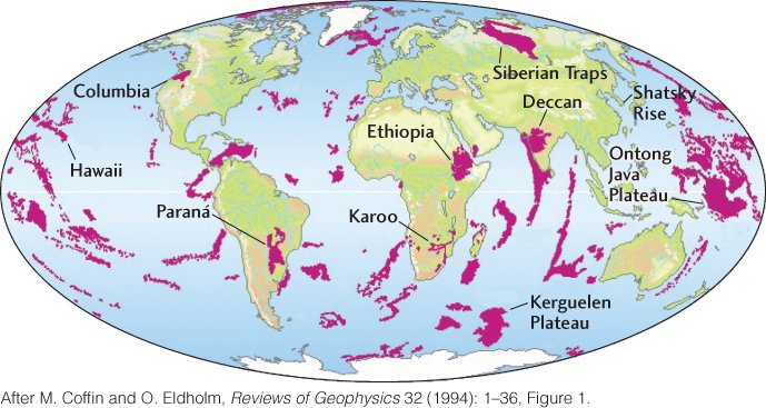
The fissure eruption that covered much of Siberia with basaltic lava is of special interest to geobiologists because it happened at the same time as the greatest mass extinction in the geologic record, which occurred at the end of the Permian period, about 251 million years ago (see Chapter 11). Some geologists think that the eruption caused the mass extinction, perhaps by polluting the atmosphere with volcanic gases that triggered major climate changes (see the Practicing Geology Exercise at the end of the chapter).
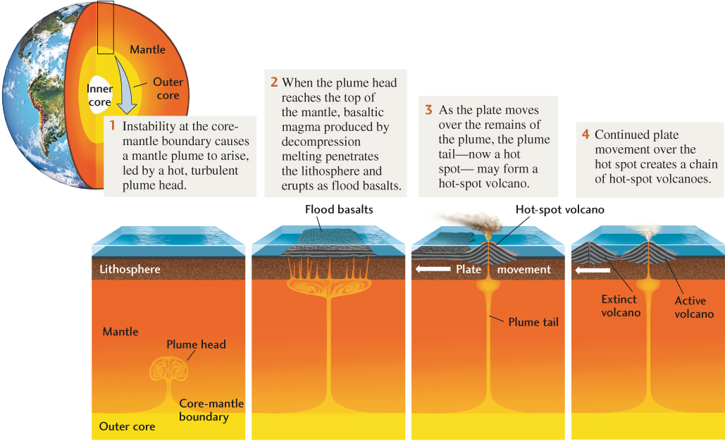
Many geologists believe that almost all LIPs were created at hot spots by mantle plumes. However, the amount of lava erupting from the most active hot spot on Earth today, Hawaii, is paltry compared with the enormous outpourings of fissure eruptions. What explains these unusual bursts of basaltic magma from the mantle? Some geologists speculate that they result when a new plume rises from the core-mantle boundary. According to this hypothesis, a large, turbulent blob of hot material—a “plume head”—leads the way. When this plume head reaches the top of the mantle, it generates a huge quantity of magma by decompression melting, which erupts in massive flood basalts (Figure 12.28). Others dispute this hypothesis, pointing out that continental flood basalts often seem to be associated with preexisting zones of weakness in the continental crust and suggesting that the magmas are generated by convective processes localized in the upper mantle. Sorting out the origins of LIPs is one of the most exciting areas of current geologic research.
334